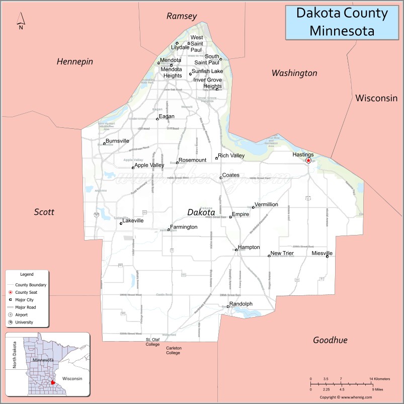
Dakota County is the third-most populous county in the U.S. state of Minnesota, located in the east central portion of the state. As of the 2020 census, the population was 439,882. The population of Dakota County was estimated to be 442,038 in 2021. The county seat is Hastings. Dakota County is named for the Dakota Sioux tribal bands who inhabited the area. The name is recorded as “Dahkotah” in the United States Census records until 1851. Dakota County is included in the Minneapolis–St. Paul–Bloomington, MN–WI Metropolitan Statistical Area, the sixteenth largest metropolitan area in the United States with about 3.64 million residents. The largest city in Dakota County is the city of Lakeville, the eleventh-largest city in Minnesota and sixth-largest Twin Cities suburb. The county is bordered by the Minnesota and Mississippi Rivers on the north, and the state of Wisconsin on the east.
| Name: | Dakota County |
|---|---|
| FIPS code: | 27-037 |
| State: | Minnesota |
| Founded: | October 27, 1849 |
| Named for: | Dakota people |
| Seat: | Hastings |
| Largest city: | Lakeville |
| Total Area: | 587 sq mi (1,520 km²) |
| Land Area: | 562 sq mi (1,460 km²) |
| Total Population: | 439,882 |
| Population Density: | 786/sq mi (303/km²) |
| Time zone: | UTC−6 (Central) |
| Summer Time Zone (DST): | UTC−5 (CDT) |
| Website: | www.dakotacounty.us |
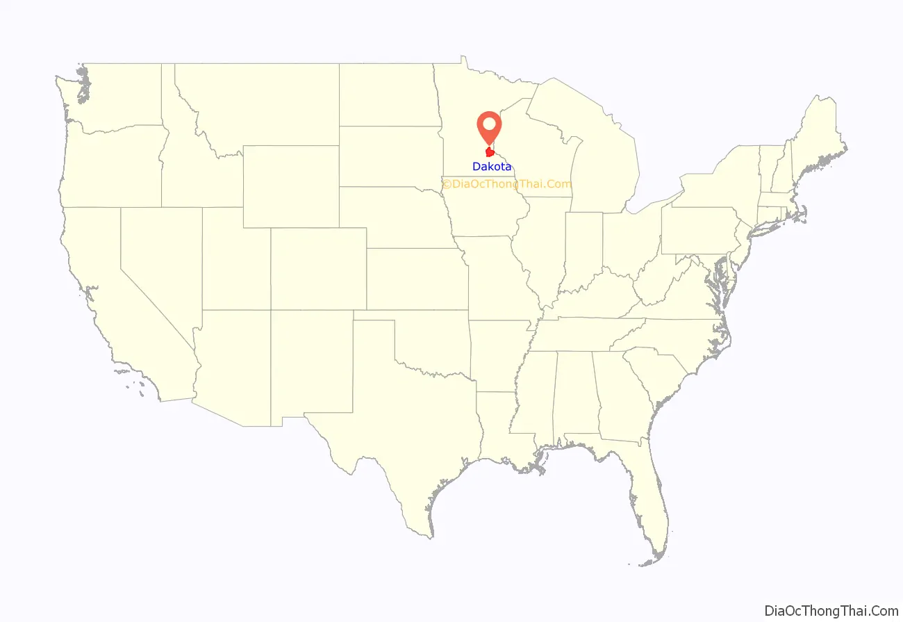
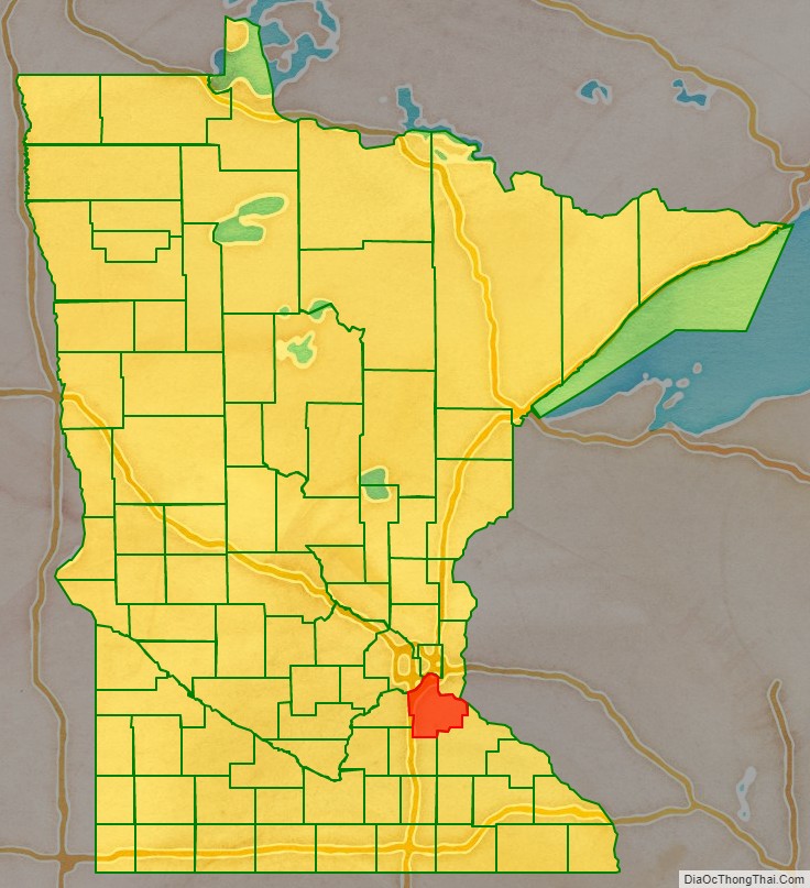
Dakota County location map. Where is Dakota County?
History
The county was the site of historical events at Mendota that defined the state’s future, including providing materials for the construction of Fort Snelling across the river and the signing of the Treaty of Traverse des Sioux which ceded land from the native Dakota nation for the Minnesota Territory. The county’s history was initially tied to the confluence of the Mississippi and Minnesota Rivers, both strategically important for United States expansion and as the convergence of the Dakota and Ojibwe nations who regarded the site as sacred. Influence shifted westward during the post-World War II settlement boom when Interstate 35 connected the western half of the county to Minneapolis and Saint Paul and bedroom communities grew. Most work outside the county but like many metro counties, Dakota continues to absorb industry and jobs from the core cities.
In the 1600s, Mdewakanton Dakota fled their ancestral home of Mille Lacs Lake in northern Minnesota in response to westward expansion of the Ojibwe nation. According to Dakota tradition, their ancestors pushed out the Iowa who were found settled at the mouth of the Minnesota River. In 1680, the Mdewakanton Dakota were contacted by French explorer Daniel Greysolon, Sieur du Lhut, and the Mendota (mdo-TE) band of the Mdewakanton south of the Minnesota River were contacted by Joseph Nicollet in the 18th century. While Taoyateduta (a.k.a. Little Crow) led the Mendota in northern Dakota County, upstream to the southwest, Chief Black Dog established his village of 600 people around 1750 at the isthmus between Black Dog Lake (which is named after him) and the Minnesota River, near the present site of the Black Dog Power Plant.
Following the published expeditions of explorers, in 1805, Zebulon Pike negotiated for military territory with the Mendota band which included land in Dakota County at the Mississippi River confluences with the Minnesota and St. Croix Rivers. In 1819, on what is now Picnic Island on the south bank of the Minnesota River, Colonel Henry Leavenworth built a stockade fort called “St. Peter’s Cantonment” or “New Hope,” where materials were assembled for the construction of Fort Snelling to be built on the bluff on the north bank. Permanent settlement on the island was impossible due to annual flooding. Alexis Bailey built some log buildings nearby to trade in furs in 1826. Henry Hastings Sibley later built the first stone house in Minnesota in 1836, overlooking Fort Snelling. Sibley was a partner in the American Fur Company, and considerable fur trade occurred at Mendota due to the accessibility of the confluence.
Ongoing United States expansion into the then “Northwest Territory” led to government purchase of land from the Dakota people (the Mdewakanton, Wahpekute, Wahpeton, and Sisseton bands) via the Treaty of St. Peters, the Treaty of Traverse des Sioux, and the Treaty of Mendota in 1851. After the Minnesota Territory was established in 1849, Dakotah County (later Dakota County) spanned from the Mississippi River to the Missouri River. By the time Minnesota achieved statehood in 1858, power and influence had shifted from Mendota, across the rivers to Saint Paul and Minneapolis.
Hastings and South St. Paul
By 1900, the hub of activity in the county was in Hastings, the county seat, and a focal point of transportation, communication, and commerce. St. Peter’s, now Mendota, had lost out to Fort Snelling. Hastings is located on the Mississippi River at the confluence of the St. Croix River and on the Vermillion River, which provided ample water power. Lumber, milling, and railroads provided good incomes. During this time, the stockyards and meat-packing plants in South St. Paul, Minnesota became the world’s largest stockyards. Ranchers in the west shipped their livestock to St. Louis, Memphis, and New Orleans. These plants were worked by immigrants from Romania, Serbia, and other Eastern European countries. The rest of the county remained agricultural during the boom of milling activity north of the Minnesota River due to lack of bridge connections. Rail access came in 1866 via the Chicago, St. Paul, Minneapolis, and Omaha Railroad which shipped grain to millers. The Minneapolis St. Paul Rochester and Dubuque Electric Traction Company line in 1905 (now the Dan Patch Corridor), was primary for passengers going to resorts in Burnsville and Lakeville.
Suburban growth
By the 1950s, population growth shifted to western Dakota county, which had been predominantly Irish and Scottish extending southward toward the Scandinavians of Southern Minnesota. As population pressures expanded south from Minneapolis and Bloomington, the completion of Interstate 35W and 35E brought about major construction in the post-World War II period, turning villages into cities within 20 years. Burnsville, Apple Valley, Eagan, and Lakeville brought over 200,000 people into the county by the end of the century. The Western and Northern Service Centers were constructed in the early 1990s each with an additional courthouse location. License centers were subsequently set up in Burnsville and Lakeville. Though pressure remained since the postwar boom to move the county seat to a larger community, the Dakota County Board maintained the seat in Hastings, while providing government services across the county.
Historic sites
The history of the county is well-illustrated by the Registered Historic Places in the county, including the settlement at Mendota, the homes of well-heeled residents of Hastings, the ethnic gathering places in South Saint Paul, and other sites related to life on the prairie, including religion, education, transportation, commerce, and farm life.
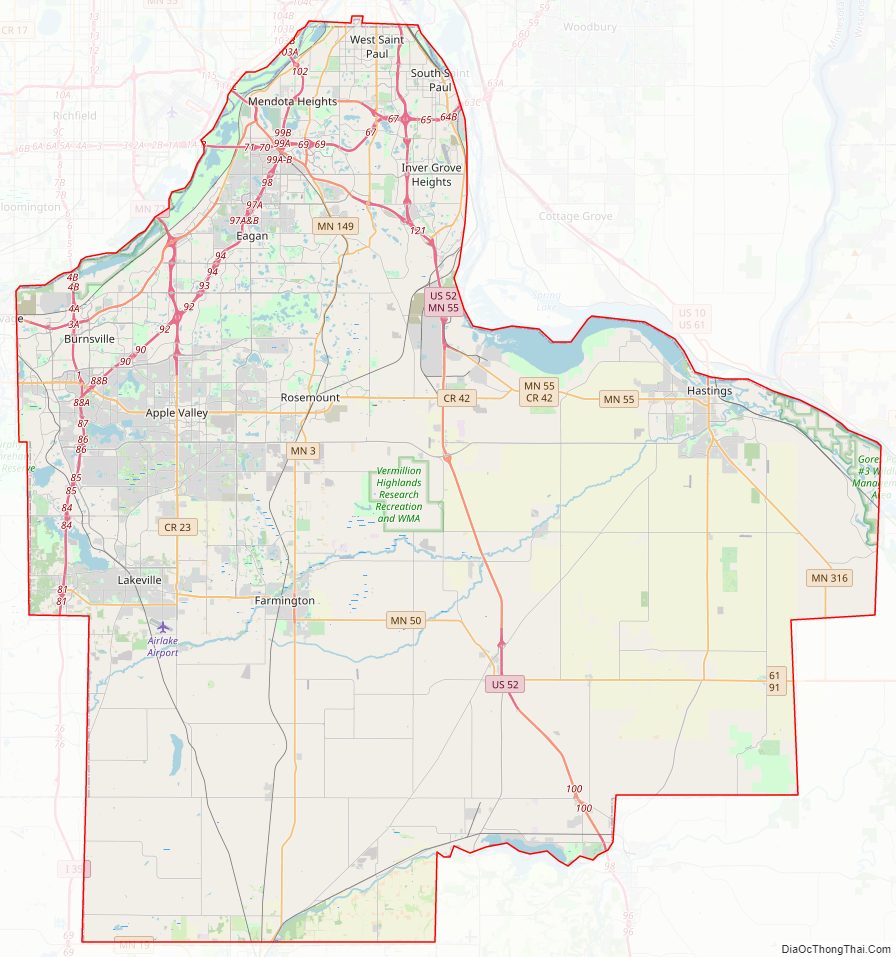
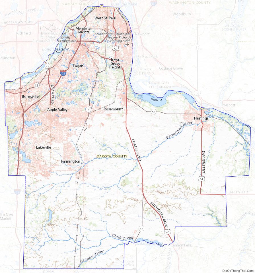
Dakota County Road Map
Geography
The county terrain consists of low rolling hills, sloping to the river valleys. Its highest point is at Buck Hill in Burnsville, at 1,168 feet. ASL. The county has a total area of 587 square miles (1,520 km), of which 562 square miles (1,460 km) is land and 25 square miles (65 km) (4.2%) is water.
Rivers
The northern and eastern boundaries of Dakota County are marked by the Minnesota and Mississippi Rivers. Management and jurisdiction of the rivers falls into multiple local, State and Federal agencies. Most of the Minnesota River bank is under the Minnesota Valley National Wildlife Refuge with fish, wildlife, and parkland managed collectively by the United States Fish and Wildlife Service and the Minnesota Department of Natural Resources. The Dakota County Soil and Water Conservation District assists the county’s six watershed management organizations (WMO) which include the Black Dog WMO, Gun Club Lake WMO, Lower Minnesota River Watershed District, Lower Mississippi WMO, North Cannon River WMO, and the Vermillion River Watershed Joint Powers Organization.
- Mississippi River: Adjacent to Mendota Heights, Lilydale, South St. Paul, Inver Grove Heights, Rosemount, and Hastings.
- Minnesota River: Adjacent to Burnsville, Eagan, Mendota Heights, and Mendota.
- Vermillion River: From Farmington through Empire Township to Hastings.
- Cannon River: Adjacent to Randolph and through Randolph Township.
Lakes
- Crystal Lake
Eagan
- Blackhawk Lake
- Fish Lake
- Holland Lake
- Jensen Lake
- Thomas Lake
Eureka Township
- Chub Lake
Hastings
- Lake Rebecca
- Lake Isabelle
- Spring Lake
- Bullfrog Pond
Lakeville
- Lake Marion
- Orchard Lake
- Kingsley Lake
- Valley Lake
- Lee Lake
Lilydale
- Pickerel Lake
Randolph Township
- Lake Byllesby
Ravenna Township
- Mud Hen Lakes
Rosemount
- Keegan Lake
West Saint Paul
- Thompson Lake
South St. Paul
- Siedls Lake
Major highways
- Interstate 35
- Interstate 35E
- Interstate 35W
- Interstate 494
- US Highway 52
- US Highway 61
- Minnesota State Highway 3
- Minnesota State Highway 13
- Minnesota State Highway 19
- Minnesota State Highway 20
- Minnesota State Highway 50
- Minnesota State Highway 55
- Minnesota State Highway 56
- Minnesota State Highway 62
- Minnesota State Highway 77
- Minnesota State Highway 149
- Minnesota State Highway 156
- Minnesota State Highway 316
- County Road 42
- County Road 23
- Other County Roads
Adjacent counties
- Ramsey County – north
- Washington County – northeast
- Pierce County, Wisconsin – east
- Goodhue County – southeast
- Rice County – southwest
- Scott County – west
- Hennepin County – northwest
Protected areas
The following protected areas are within or partially within Dakota County:
- Chub Lake Wildlife Management Area
- Fort Snelling State Park (part)
- Hastings Sand Coulee Scientific and Natural Area
- Miesville Ravine Park Reserve (part)
- Minnesota Valley National Wildlife Refuge (part)
- Mississippi National River and Recreation Area (part)
- Murphy-Hanrehan Park Reserve (part)
- National Wildlife Refuge, Bloomington (part)
- Spring Lake Regional Park & Park Reserve
- Vermillion Highlands
- Whitetail Woods Regional Park
Parks
The following parks are located within Dakota County:
- Big Rivers Regional Trail
- Dakota County Bikeway System
- Dakota Woods Dog Park
- Lake Byllesby Regional Park
- Lebanon Hills Regional Park
- Thompson County Park
Dakota County Topographic Map
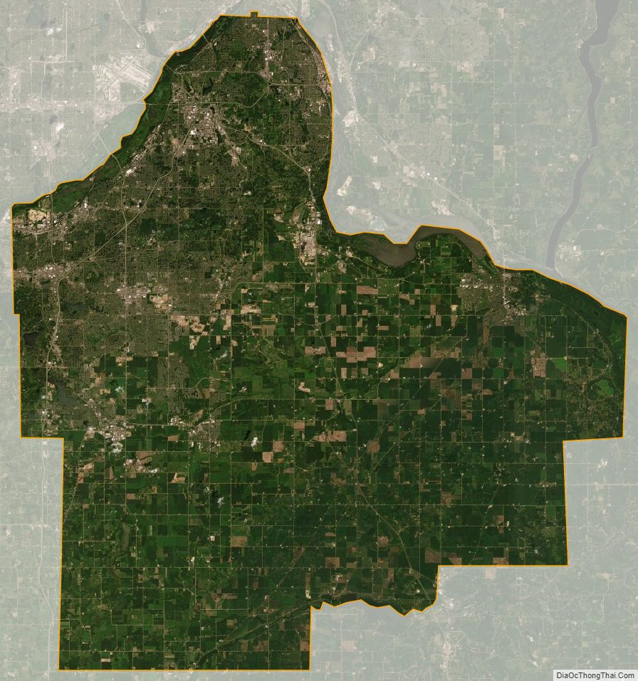
Dakota County Satellite Map
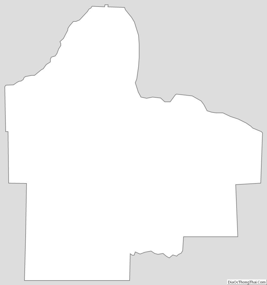
Dakota County Outline Map