Portland (/ˈpɔːrtlənd/ PORT-lənd) is a port city in the Pacific Northwest and the largest city in the U.S. state of Oregon. Situated in the northwestern area of the state at the confluence of the Willamette and Columbia rivers, Portland is the county seat of Multnomah County, the most populous county in Oregon. As of 2020, Portland had a population of 652,503, making it the 26th-most populated city in the United States, the sixth-most populous on the West Coast, and the second-most populous in the Pacific Northwest, after Seattle. Approximately 2.5 million people live in the Portland metropolitan statistical area, making it the 25th most populous in the United States. About half of Oregon’s population resides within the Portland metropolitan area.
Named after Portland, Maine, the Oregon settlement began to be populated in the 1840s, near the end of the Oregon Trail. Its water access provided convenient transportation of goods, and the timber industry was a major force in the city’s early economy. At the turn of the 20th century, the city had a reputation as one of the most dangerous port cities in the world, a hub for organized crime and racketeering. After the city’s economy experienced an industrial boom during World War II, its hard-edged reputation began to dissipate. Beginning in the 1960s, Portland became noted for its growing liberal and progressive political values, earning it a reputation as a bastion of counterculture.
The city operates with a commission-based government, guided by a mayor and four commissioners, as well as Metro, the only directly elected metropolitan planning organization in the United States. Its climate is marked by warm, dry summers and cool, rainy winters. This climate is ideal for growing roses, and Portland has been called the “City of Roses” for over a century.
| Name: | Portland city |
|---|---|
| LSAD Code: | 25 |
| LSAD Description: | city (suffix) |
| State: | Oregon |
| County: | Clackamas County, Multnomah County, Washington County |
| Founded: | 1845; 178 years ago (1845) |
| Incorporated: | February 8, 1851; 172 years ago (1851-02-08) |
| Elevation: | 50 ft (15.2 m) |
| Land Area: | 133.49 sq mi (345.73 km²) |
| Water Area: | 11.51 sq mi (29.82 km²) |
| Population Density: | 4,888.10/sq mi (1,887.30/km²) |
| FIPS code: | 4159000 |
| GNISfeature ID: | 1136645 |
| Website: | www.portlandoregon.gov |
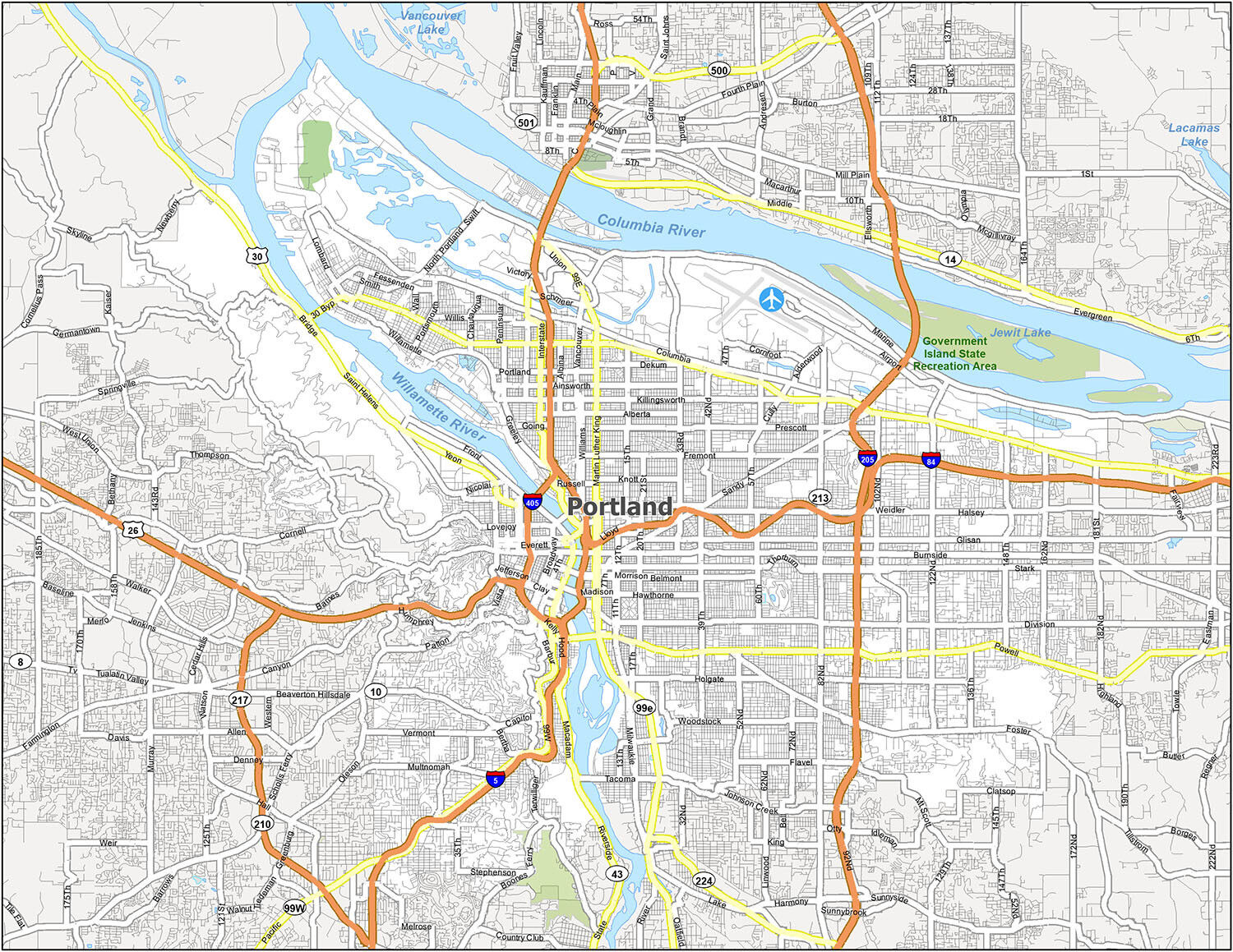
Explore Portland Oregon with our free map collection! Our maps display roads, places of interest, and other reference information that you need to know when you’re exploring the city. From the best places to eat, drink, and shop, to the most scenic routes and natural beauty, our maps are the perfect companion for your Portland adventure. Check out our interactive web map below provided by Google Maps and start planning your Portland adventure today!
Online Interactive Map
Click on ![]() to view map in "full screen" mode.
to view map in "full screen" mode.
Portland, Oregon is a city that knows how to have fun and enjoy the outdoors. It is situated along the Columbia River, bordering the state of Washington. While the Tualatin Mountains are in the west, the Cascade Range stands tall in the east. But if you’re looking to stay in the city, this interactive map can help you find all the best hotels, restaurants, and attractions. Get the most out of your vacation by finding everything you need. Whether you’re visiting for the weekend or just want to discover why Portland is called the “City of Roses”, this map is going to give you the help you need.
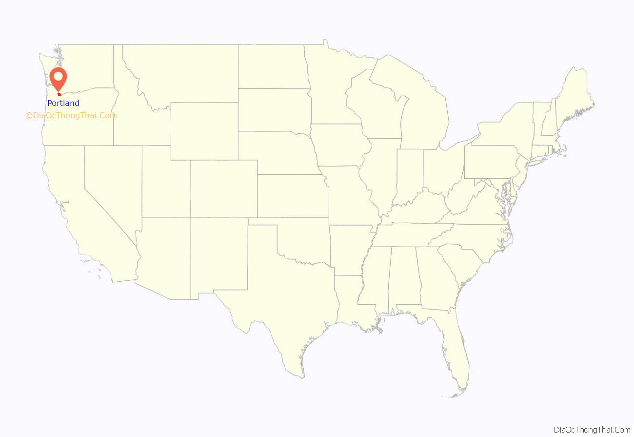
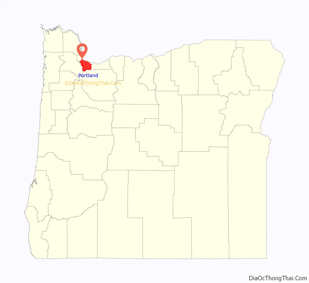
Portland location map. Where is Portland city?
History
Pre-history
During the prehistoric period, the land that would become Portland was flooded after the collapse of glacial dams from Lake Missoula, in what would later become Montana. These massive floods occurred during the last ice age and filled the Willamette Valley with 300 to 400 feet (91 to 122 m) of water.
Before American settlers began arriving in the 1800s, the land was inhabited for many centuries by two bands of indigenous Chinook people – the Multnomah and the Clackamas. The Chinook people occupying the land were first documented in 1805 by Meriwether Lewis and William Clark. Before its European settlement, the Portland Basin of the lower Columbia River and Willamette River valleys had been one of the most densely populated regions on the Pacific Coast.
Establishment
Large numbers of pioneer settlers began arriving in the Willamette Valley in the 1840s via the Oregon Trail, with many arriving in nearby Oregon City. A new settlement then emerged ten miles from the mouth of the Willamette River, roughly halfway between Oregon City and Hudson’s Bay Company’s Fort Vancouver. This community was initially referred to as “Stumptown” and “The Clearing” because of the many trees cut down to allow for its growth. In 1843 William Overton saw potential in the new settlement but lacked the funds to file an official land claim. For 25 cents, Overton agreed to share half of the 640-acre (2.6 km) site with Asa Lovejoy of Boston.
In 1845, Overton sold his remaining half of the claim to Francis W. Pettygrove of Portland, Maine. Both Pettygrove and Lovejoy wished to rename “The Clearing” after their respective hometowns (Lovejoy’s being Boston, and Pettygrove’s, Portland). This controversy was settled with a coin toss that Pettygrove won in a series of two out of three tosses, thereby providing Portland with its namesake. The coin used for this decision, now known as the Portland Penny, is on display in the headquarters of the Oregon Historical Society. At the time of its incorporation on February 8, 1851, Portland had over 800 inhabitants, a steam sawmill, a log cabin hotel, and a newspaper, the Weekly Oregonian. A major fire swept through downtown in August 1873, destroying twenty blocks on the west side of the Willamette along Yamhill and Morrison Streets, and causing $1.3 million in damage, roughly equivalent to $29.4 million today. By 1879, the population had grown to 17,500 and by 1890 it had grown to 46,385. In 1888, the first steel bridge on the West Coast was opened in Portland, the predecessor of the 1912 namesake Steel Bridge that survives today. In 1889, Henry Pittock’s wife, Georgiana, established the Portland Rose Society. The movement to make Portland a “Rose City” started as the city was preparing for the 1905 Lewis and Clark Centennial Exposition.
Portland’s access to the Pacific Ocean via the Willamette and Columbia rivers, as well as its easy access to the agricultural Tualatin Valley via the “Great Plank Road” (the route of current-day U.S. Route 26), provided the pioneer city with an advantage over other nearby ports, and it grew very quickly. Portland remained the major port in the Pacific Northwest for much of the 19th century, until the 1890s, when Seattle’s deepwater harbor was connected to the rest of the mainland by rail, affording an inland route without the treacherous navigation of the Columbia River. The city had its own Japantown, for one, and the lumber industry also became a prominent economic presence, due to the area’s large population of Douglas fir, western hemlock, red cedar, and big leaf maple trees.
Portland developed a reputation early in its history as a hard-edged and gritty port town. Some historians have described the city’s early establishment as being a “scion of New England; an ends-of-the-earth home for the exiled spawn of the eastern established elite.” In 1889, The Oregonian called Portland “the most filthy city in the Northern States”, due to the unsanitary sewers and gutters, and, at the turn of the 20th century, it was considered one of the most dangerous port cities in the world. The city housed a large number of saloons, bordellos, gambling dens, and boardinghouses which were populated with miners after the California Gold Rush, as well as the multitude of sailors passing through the port. By the early 20th century, the city had lost its reputation as a “sober frontier city” and garnered a reputation for being violent and dangerous.
20th-century development
Between 1900 and 1930, the city’s population tripled from nearly 100,000 to 301,815. During World War II, it housed an “assembly center” from which up to 3,676 people of Japanese descent were dispatched to internment camps in the heartland. It was the first American city to have residents report thus, and the Pacific International Livestock Exposition operated from May through September 10, 1942, processing people from the city, northern Oregon, and central Washington. General John DeWitt called the city the first “Jap-free city on the West Coast.”
At the same time, Portland became a notorious hub for underground criminal activity and organized crime in the 1940s and 1950s. In 1957, Life magazine published an article detailing the city’s history of government corruption and crime, specifically its gambling rackets and illegal nightclubs. The article, which focused on crime boss Jim Elkins, became the basis of a fictionalized film titled Portland Exposé (1957). In spite of the city’s seedier undercurrent of criminal activity, Portland enjoyed an economic and industrial surge during World War II. Ship builder Henry J. Kaiser had been awarded contracts to build Liberty ships and aircraft carrier escorts, and chose sites in Portland and Vancouver, Washington, for work yards. During this time, Portland’s population rose by over 150,000, largely attributed to recruited laborers.
During the 1960s, an influx of hippie subculture began to take root in the city in the wake of San Francisco‘s burgeoning countercultural scene. The city’s Crystal Ballroom became a hub for the city’s psychedelic culture, while food cooperatives and listener-funded media and radio stations were established. A large social activist presence evolved during this time as well, specifically concerning Native American rights, environmentalist causes, and gay rights. By the 1970s, Portland had well established itself as a progressive city, and experienced an economic boom for the majority of the decade; however, the slowing of the housing market in 1979 caused demand for the city and state timber industries to drop significantly.
Since 1990
In the 1990s, the technology industry began to emerge in Portland, specifically with the establishment of companies such as Intel, which brought more than US$10 billion in investments in 1995 alone. After 2000, Portland experienced significant growth, with a population rise of over 90,000 between the years 2000 and 2014. The city’s increasing reputation for culture established it as a popular city for young people, and it was second only to Louisville, Kentucky as one of the cities to attract and retain the highest number of college-educated people in the United States. Between 2001 and 2012, Portland’s gross domestic product per person grew by fifty percent, more than any other city in the country.
The city acquired a diverse range of nicknames throughout its history, though it is most often called “Rose City” or “The City of Roses” (unofficial nickname since 1888, official since 2003). Another widely used nickname by local residents in everyday speech is “PDX”, the airport code for Portland International Airport. Other nicknames include Bridgetown, Stumptown, Rip City, Soccer City, P-Town, Portlandia, and the more antiquated Little Beirut.
From May 28, 2020 until spring 2021, there were daily protests about the murder of George Floyd by police, and racial injustice. There were instances of looting, vandalism, and police actions causing injuries. One protestor was killed by an opposing one. Local businesses reported losses totaling millions of dollars as the result of vandalism and looting, according to Oregon Public Broadcasting. Some protests caused injury to protesters and police. In July, federal officers were deployed to safeguard federal property; their presence and tactics were criticized by Oregon officials, who demanded they leave, while lawsuits were filed against local and federal law enforcement alleging wrongful actions by them.
On May 25, 2021, a protest to commemorate the one-year anniversary of Floyd’s murder caused property damage, and was followed by a number of arrests.
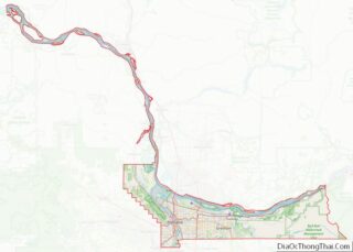
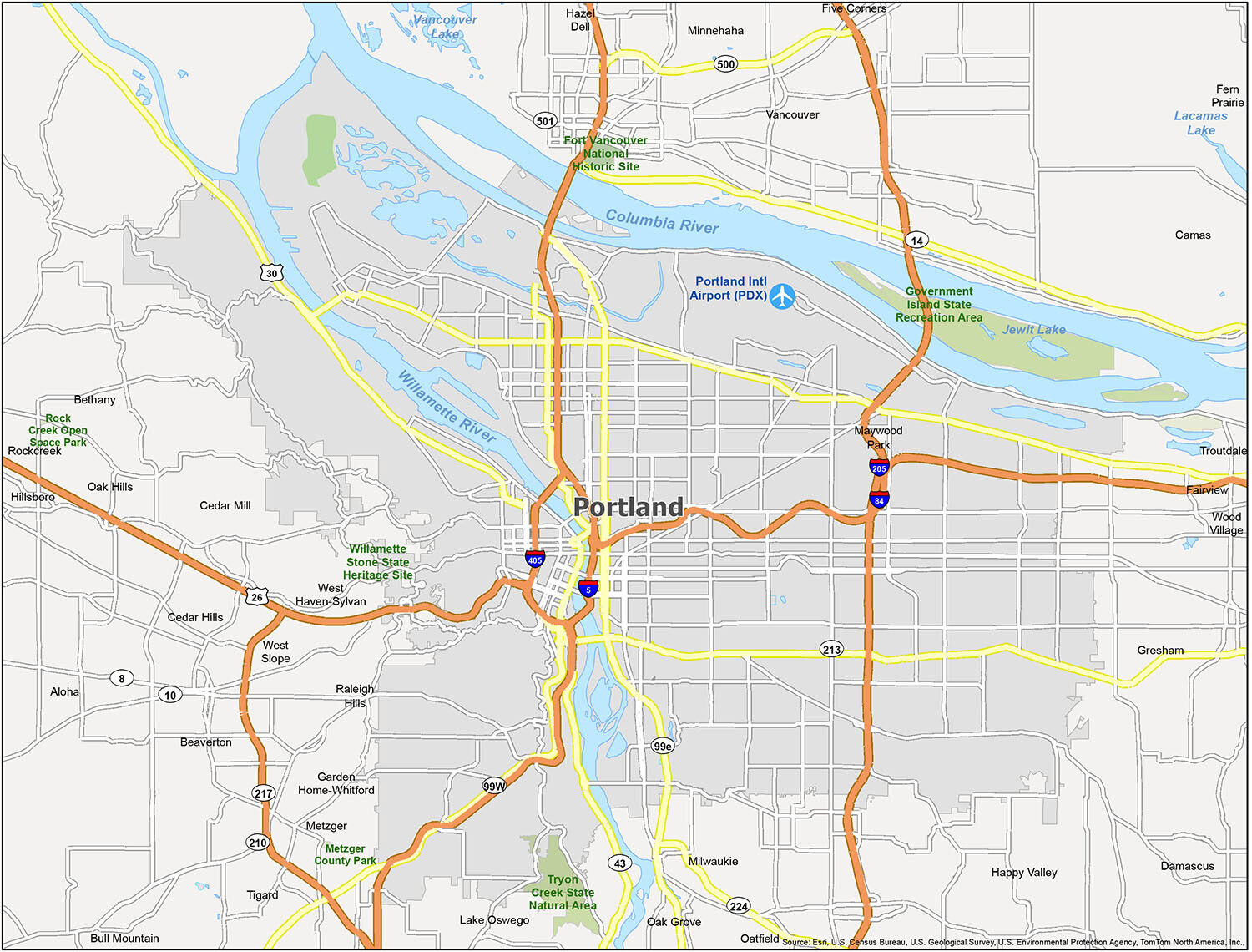
Portland Road Map
This printable road map is a great way to find your way around the city. A detailed overview of color-coded interstate highways and major roads will make planning your next visit easier than ever. If you’re visiting Portland and want to see the best of the city, this map will help you navigate around everywhere. You can never go wrong with printing a road map before your voyage. But for any travel outside the city, refer to this Oregon road map with highway information.
Interstate Highways: I-5, I-84, I-205, I-405
US Highways: 5, 26, 30, 84, 99E, 99W, Beaverton Hillsdale Highway, Capitol Highway, Cascade Highway, Pacific Highway, Portland Highway, Swift Highway
Parkways: Naito Parkway, River Parkway
Major Roads: Barbur Boulevard, Belmont Street, Grand Avenue, Martin Luther King Boulevard, Mcloughlin Boulevard, Morrison Street, Saint Helens Road, Yeon Avenue
When planning a visit to Portland, a printable road map is the ideal way to find your way around the city. This map provides a detailed overview of color-coded interstate highways and major roads to make your trip easier. With this map, you can easily navigate around everywhere and see the best of Portland. Print the map before your voyage for added convenience. For any travel outside the city, refer to the Oregon road map with detailed highway information.
Interstate Highways: I-5, I-84, I-205, I-405
US Highways: 5, 26, 30, 84, 99E, 99W, Beaverton Hillsdale Highway, Capitol Highway, Cascade Highway, Pacific Highway, Portland Highway, Swift Highway
Parkways: Naito Parkway, River Parkway
Major Roads: Barbur Boulevard, Belmont Street, Grand Avenue, Martin Luther King Boulevard, Mcloughlin Boulevard, Morrison Street, Saint Helens Road, Yeon Avenue
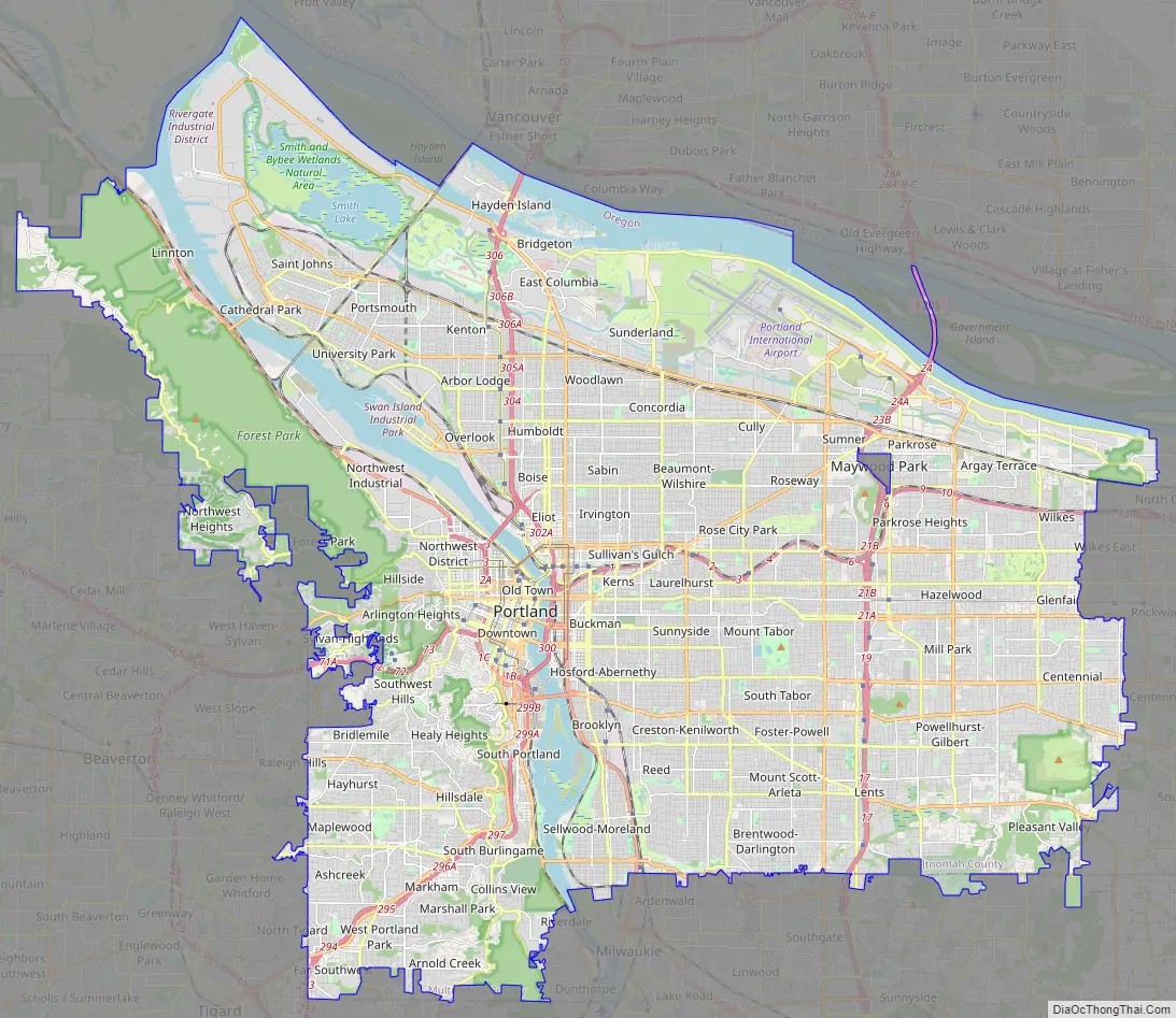
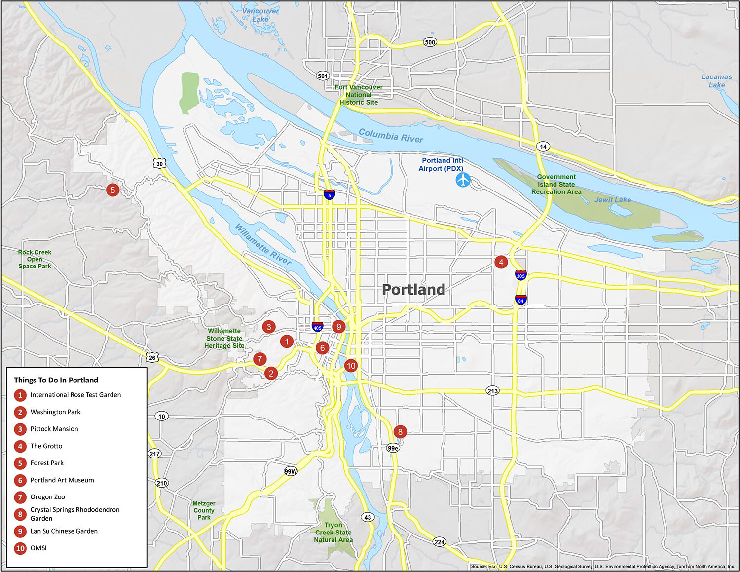
Portland is not only the most populous city in the state, but it’s also consistently ranked as one of the best places to live in the nation. One of its biggest advantages is its natural beauty. From Portland, you can see some of the most beautiful topographic landscapes in all of the United States, including Mt. Hood, Mt. St. Helens, Mt. Adams, and Mt. Rainier. To help you explore the city at your own pace and without the hassle of wandering around aimlessly, we’ve included a map that highlights parks, rivers, and other points of interest.
Airports: Portland International Airport (PDX)
Cities: Beaverton, Camas, Fairview, Gresham, Happy Valley, Hillsboro, Lake Oswego, Maywood Park, Milwaukie, Portland, Tigard, Troutdale, Vancouver, Wood Village
Census-designated place (CDP): Aloha, Bethany, Bull Mountain, Cedar Hills, Cedar Mill, Damascus, Fern Prairie, Five Corners, Garden Home-Whitford, Hazel Dell, Metzger, Minnehaha, Oak Grove, Oak Hills, Oatfield, Raleigh Hills, Rockcreek, West Haven-Sylvan, West Slope
10 things to do in Portland city
Portland, Oregon is a city that knows how to have fun and enjoy the outdoors. It is situated along the Columbia River, bordering the state of Washington. While the Tualatin Mountains are in the west, the Cascade Range stands tall in the east. But if you’re looking to stay in the city, this interactive map can help you find all the best hotels, restaurants, and attractions. Get the most out of your vacation by finding everything you need. Whether you’re visiting for the weekend or just want to discover why Portland is called the “City of Roses”, this map is going to give you the help you need.
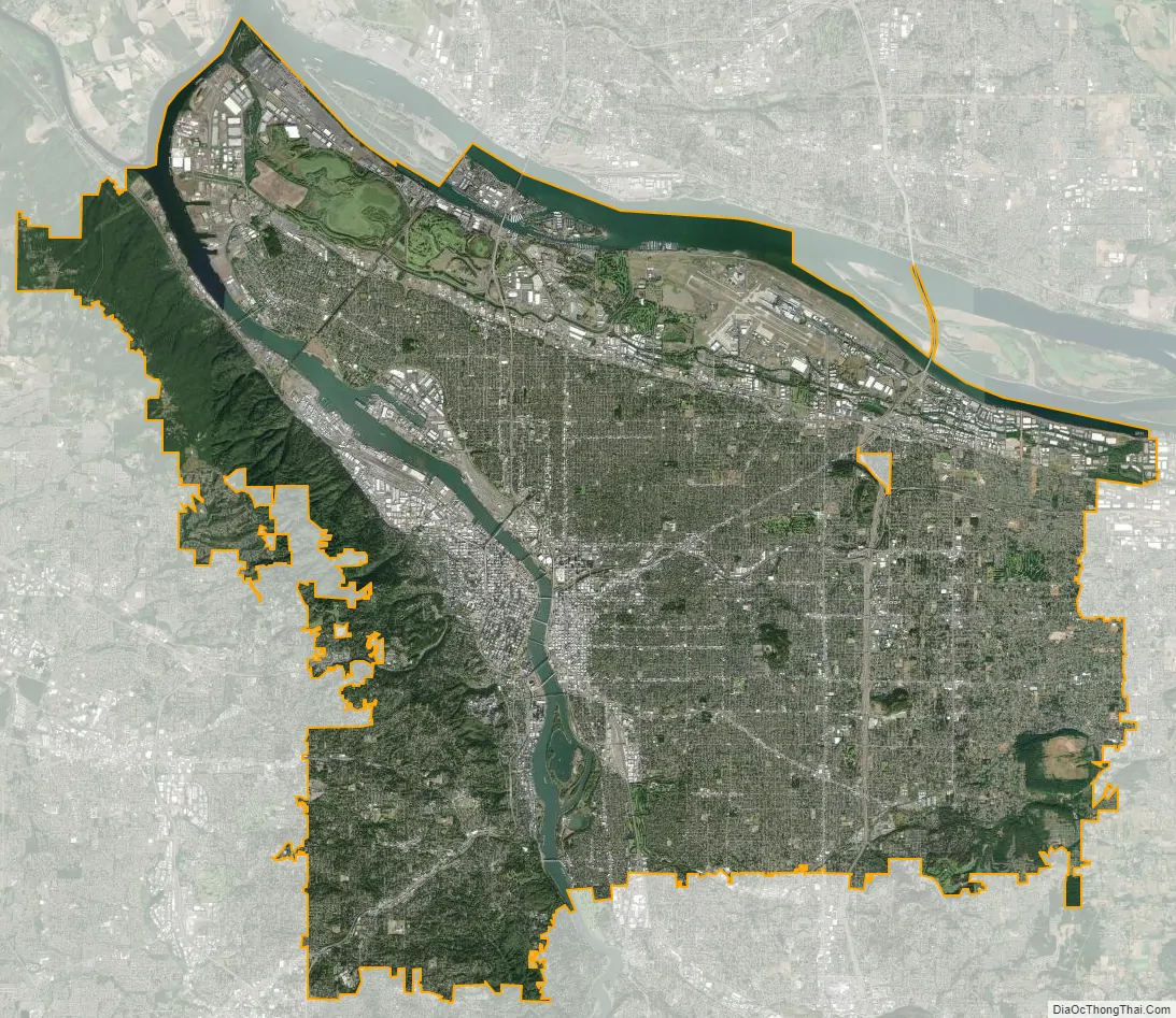
Portland city Satellite Map
See also
Map of Oregon State and its subdivision: Map of other states:- Alabama
- Alaska
- Arizona
- Arkansas
- California
- Colorado
- Connecticut
- Delaware
- District of Columbia
- Florida
- Georgia
- Hawaii
- Idaho
- Illinois
- Indiana
- Iowa
- Kansas
- Kentucky
- Louisiana
- Maine
- Maryland
- Massachusetts
- Michigan
- Minnesota
- Mississippi
- Missouri
- Montana
- Nebraska
- Nevada
- New Hampshire
- New Jersey
- New Mexico
- New York
- North Carolina
- North Dakota
- Ohio
- Oklahoma
- Oregon
- Pennsylvania
- Rhode Island
- South Carolina
- South Dakota
- Tennessee
- Texas
- Utah
- Vermont
- Virginia
- Washington
- West Virginia
- Wisconsin
- Wyoming