Allakaket (/æləˈkækɪt/ al-ə-KAK-it) (Aalaa Kkaakk’et in Koyukon) is a second class city in the Yukon-Koyukuk Census Area of the Unorganized Borough of the U.S. state of Alaska. The population was 105 at the 2010 census.
| Name: | Allakaket city |
|---|---|
| LSAD Code: | 25 |
| LSAD Description: | city (suffix) |
| State: | Alaska |
| County: | Yukon-Koyukuk Census Area |
| Incorporated: | 1975 |
| Elevation: | 400 ft (122 m) |
| Total Area: | 17.03 sq mi (44.12 km²) |
| Land Area: | 14.72 sq mi (38.12 km²) |
| Water Area: | 2.32 sq mi (6.00 km²) |
| Total Population: | 177 |
| Population Density: | 12.03/sq mi (4.64/km²) |
| ZIP code: | 99720 |
| Area code: | 907 |
| FIPS code: | 0201860 |
| GNISfeature ID: | 1398129 |
Online Interactive Map
Click on ![]() to view map in "full screen" mode.
to view map in "full screen" mode.
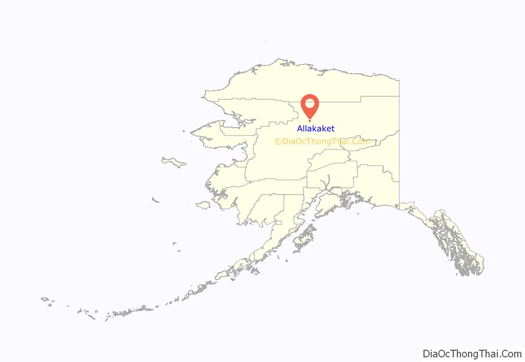
Allakaket location map. Where is Allakaket city?
History
Several Native groups have lived in the area, including Koyukon Athabascans and Kobuk, Selawik, and Nunamiut Eskimos from the north and northwest. The Koyukon lived in several camps throughout the year, moving as the seasons changed, following the wild game and fish. The various bands established joint settlements after 1851. The old site of Alatna was a traditional trading center for Athabascans and Eskimos.
The first mission on the Koyukuk River, St. John’s-in-the-Wilderness Episcopal Mission, was established in 1906. A post office was opened in 1925. In 1938, the name of the community was changed to Allakaket (the old name for the mission), and the name Alatna was assumed by the small Eskimo community across the river. The first public school was established in 1957. A flood caused by ice jamming inundated 85% of the community in the Spring of 1964. In 1975, the community incorporated as a City, including both settlements of Allakaket and Alatna. A clinic and airport were built in 1978. A new school and community roads were built in 1979. In September 1994, flood waters destroyed and swept away nearly all of the community’s buildings, homes, and food caches for the winter. Residents rebuilt near the old City site, but some new homes and facilities are now located outside of the incorporated City boundaries. New Allakaket and Alatna are located outside of the City limits.
A federally recognized tribe is located in the community—the Allakaket Village. The population of the community consists of 95.9% Alaska Native or part Native. Allakaket is mainly an Athabascan community; Kobuk Eskimos live across the river in Alatna. Two separate village councils exist. Traditional potlatches, dances and foot races attract visitors from area villages. Subsistence activities provide the majority of food sources. The sale, importation and possession of alcohol are banned in the village.
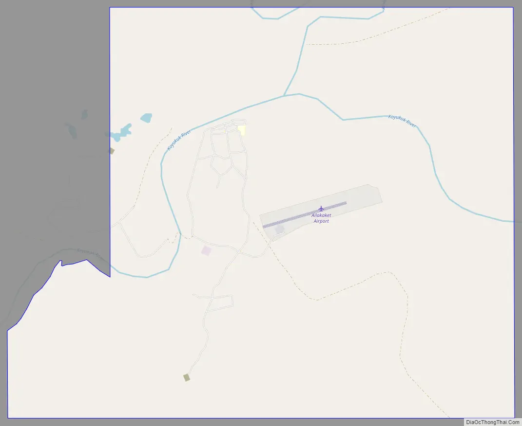
Allakaket Road Map
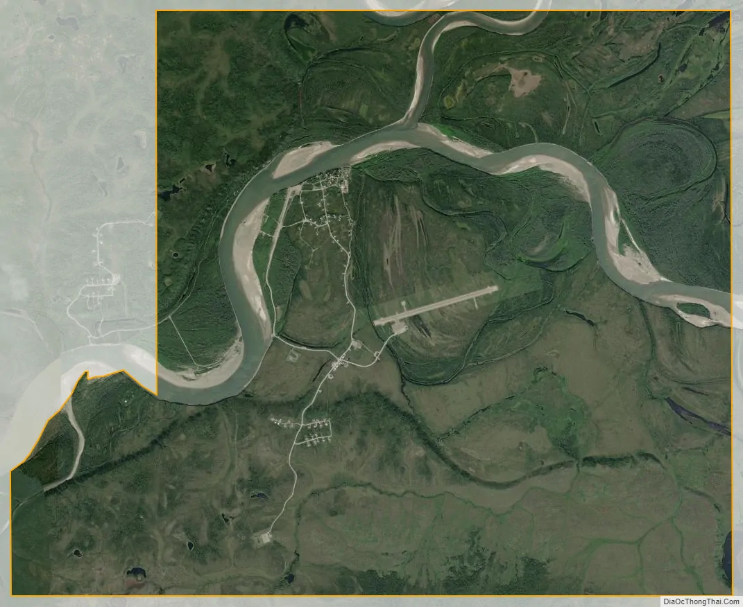
Allakaket city Satellite Map
Geography
Allakaket is located at 66°33′48″N 152°38′50″W / 66.56333°N 152.64722°W / 66.56333; -152.64722 (66.562610, -152.64756) (Sec. 14, T020N, R024W, Fairbanks Meridian.) Allakaket is located in the Fairbanks Recording District.
Allakaket is on the south bank of the Koyukuk River, southwest of its junction with the Alatna River, approximately 190 miles (310 km) northwest of Fairbanks and 57 miles (92 km) upriver from Hughes. The village of Alatna is located directly across the river.
According to the United States Census Bureau, the city has a total area of 4.3 square miles (11 km), of which, 3.6 square miles (9.3 km) of it is land and 0.7 square miles (1.8 km) of it (17.05%) is water.
Climate
Allakaket has a subarctic climate (Köppen Dfc) characterized by frigid, snowy winters and mild summers. The average high temperature during July is 70 °F or 21.1 °C. Temperatures in January fall to or below 0 °F or −17.8 °C on all but four mornings, and during December and February on all but six per month, whilst extended periods below −40 °F or −40 °C are common: the coldest month on record of January 1971 averaged −44.9 °F (−42.7 °C). Being further from the Alaska Range than Fairbanks, Allakaket is less influenced by warming chinook winds, so that temperatures have topped freezing in January only six times on record, and in December only ten times of record.
The highest temperature ever recorded was 94 °F (34.4 °C) and the lowest was −75 °F (−59.4 °C). Average precipitation is 12.41 inches or 315.2 millimetres and annual snowfall is 61.3 inches or 1.56 metres. The Koyukuk River is ice-free from June through October.
See also
Map of Alaska State and its subdivision:- Aleutians East
- Aleutians West
- Anchorage
- Bethel
- Bristol Bay
- Denali
- Dillingham
- Fairbanks North Star
- Haines
- Juneau
- Kenai Peninsula
- Ketchikan Gateway
- Kodiak Island
- Lake and Peninsula
- Matanuska-Susitna
- Nome
- North Slope
- Northwest Arctic
- Prince of Wales-Outer Ketchi
- Sitka
- Skagway-Yakutat-Angoon
- Southeast Fairbanks
- Valdez-Cordova
- Wade Hampton
- Wrangell-Petersburg
- Yukon-Koyukuk
- Alabama
- Alaska
- Arizona
- Arkansas
- California
- Colorado
- Connecticut
- Delaware
- District of Columbia
- Florida
- Georgia
- Hawaii
- Idaho
- Illinois
- Indiana
- Iowa
- Kansas
- Kentucky
- Louisiana
- Maine
- Maryland
- Massachusetts
- Michigan
- Minnesota
- Mississippi
- Missouri
- Montana
- Nebraska
- Nevada
- New Hampshire
- New Jersey
- New Mexico
- New York
- North Carolina
- North Dakota
- Ohio
- Oklahoma
- Oregon
- Pennsylvania
- Rhode Island
- South Carolina
- South Dakota
- Tennessee
- Texas
- Utah
- Vermont
- Virginia
- Washington
- West Virginia
- Wisconsin
- Wyoming


