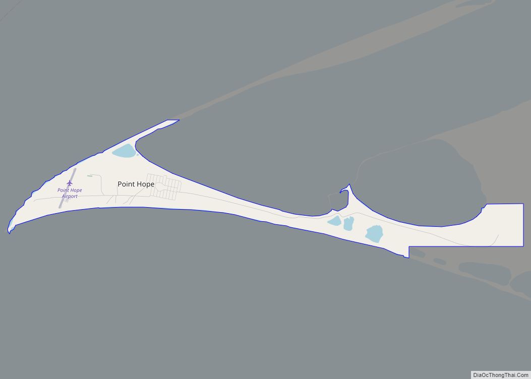
Point Hope (Inupiaq: Tikiġaq, IPA: [tikeʁɑq]) is a city in North Slope Borough, Alaska, United States. At the 2010 census the population was 674, down from 757 in 2000. In the 2020 Census, the population rose to 830.
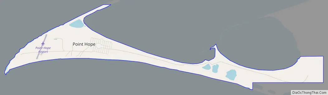
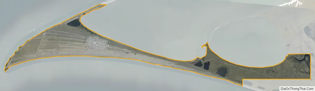
Like many isolated communities in Alaska, the city has no road or rail connections to the outside world, and must be accessed by sea or by air at Point Hope Airport.
| Name: | Point Hope city |
|---|---|
| LSAD Code: | 25 |
| LSAD Description: | city (suffix) |
| State: | Alaska |
| County: | North Slope Borough |
| Incorporated: | January 5, 1966 |
| Elevation: | 20 ft (6 m) |
| Total Area: | 5.07 sq mi (13.14 km²) |
| Land Area: | 5.00 sq mi (12.95 km²) |
| Water Area: | 0.07 sq mi (0.19 km²) |
| Total Population: | 830 |
| Population Density: | 165.97/sq mi (64.08/km²) |
| ZIP code: | 99766 |
| Area code: | 907 |
| FIPS code: | 0261630 |
| GNISfeature ID: | 1408110 |
Online Interactive Map
Click on ![]() to view map in "full screen" mode.
to view map in "full screen" mode.
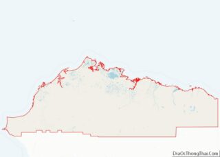
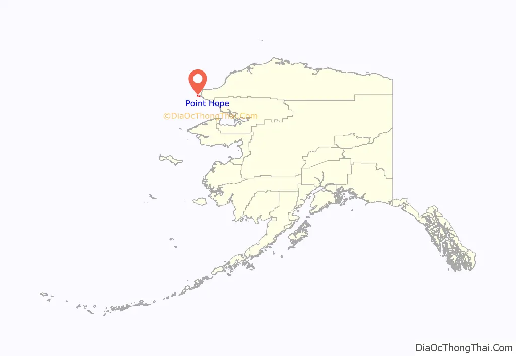
Point Hope location map. Where is Point Hope city?
History
Before any modern settlement, the Ipiutak lived here.
The descriptive Inuit name of the place, “Tikarakh” or “Tikiġaq”, commonly spelled “Tiagara”, means “forefinger”. It was recorded as “Tiekagagmiut” in 1861 by P. Tikhmeniev Wich of the Russian Hydrographic Department and on Russian Chart 1495 it became “Tiekaga”. This ancient village site was advantageous, because the protrusion of Point Hope into the sea brought the whales close to the shore. At Tikigaq, they built semi-subterranean houses using mainly whalebone and driftwood. Point Hope is one of the oldest continually occupied sites in North America. While some of the earlier dwellings have been lost to erosion as the point shrinks, it still provides valuable information to archaeologists on how early Eskimos survived in their harsh environment. The Tikigaq site is “by far the most extensive and complete one-period site yet discovered and described in the entire circumpolar region.” – Helge Larsen.
The first recorded Europeans to sight this cape were Russian explorers Mikhail Vasiliev and Gleb Shishmaryov of the Imperial Russian Navy on the ships Otkrietie and Blagonamierennie. Vasiliev and Shishmaryov named this landhead Mys Golovnina, after Vice Admiral Vasily Golovnin (1776–1831).
The cape at Point Hope was renamed by Captain Frederick William Beechey of the Royal Navy, who wrote on August 2, 1826: “I named it Point Hope in compliment to Sir William Johnstone Hope”. According to Archdeacon Stuck Hope was from a “well-known house long connected with the sea”.
Noel Wien made the first flight here in Aug. 1927.
Point Hope residents successfully opposed Project Chariot in 1962. The project would have involved buried thermonuclear detonations some 30 miles (48 km) from the village to create a deep-water artificial harbor, which would only have been usable about three months out of the year.
Point Hope Road Map
Point Hope city Satellite Map
Geography
Point Hope is located in the Point Hope landhead, at the northwestern end of the Lisburne Peninsula, on the Chukchi Sea coast, 40 miles (64 km) southwest of Cape Lisburne, Arctic Slope at 68°20′49″N 166°45′47″W / 68.34694°N 166.76306°W / 68.34694; -166.76306 (68.347052, -166.762917). It is just above the arctic circle.
According to the United States Census Bureau, the city has a total area of 6.4 square miles (17 km), of which, 6.3 square miles (16 km) of it is land and 0.1 square miles (0.26 km) of it (1.09%) is water.
In December 2017, The New York Times profiled Point Hope, reporting that “a surprising, and bittersweet, side effect of global warming” would soon bring Point Hope “one of the fastest internet connections in America”.
See also
Map of Alaska State and its subdivision:- Aleutians East
- Aleutians West
- Anchorage
- Bethel
- Bristol Bay
- Denali
- Dillingham
- Fairbanks North Star
- Haines
- Juneau
- Kenai Peninsula
- Ketchikan Gateway
- Kodiak Island
- Lake and Peninsula
- Matanuska-Susitna
- Nome
- North Slope
- Northwest Arctic
- Prince of Wales-Outer Ketchi
- Sitka
- Skagway-Yakutat-Angoon
- Southeast Fairbanks
- Valdez-Cordova
- Wade Hampton
- Wrangell-Petersburg
- Yukon-Koyukuk
- Alabama
- Alaska
- Arizona
- Arkansas
- California
- Colorado
- Connecticut
- Delaware
- District of Columbia
- Florida
- Georgia
- Hawaii
- Idaho
- Illinois
- Indiana
- Iowa
- Kansas
- Kentucky
- Louisiana
- Maine
- Maryland
- Massachusetts
- Michigan
- Minnesota
- Mississippi
- Missouri
- Montana
- Nebraska
- Nevada
- New Hampshire
- New Jersey
- New Mexico
- New York
- North Carolina
- North Dakota
- Ohio
- Oklahoma
- Oregon
- Pennsylvania
- Rhode Island
- South Carolina
- South Dakota
- Tennessee
- Texas
- Utah
- Vermont
- Virginia
- Washington
- West Virginia
- Wisconsin
- Wyoming