Tanque Verde is a suburban unincorporated community in Pima County, Arizona, United States, northeast of Tucson. The population was 16,195 at the 2000 census. For statistical purposes, the United States Census Bureau has defined Tanque Verde as a census-designated place (CDP).
| Name: | Tanque Verde CDP |
|---|---|
| LSAD Code: | 57 |
| LSAD Description: | CDP (suffix) |
| State: | Arizona |
| County: | Pima County |
| Elevation: | 2,671 ft (814 m) |
| Total Area: | 32.29 sq mi (83.64 km²) |
| Land Area: | 32.29 sq mi (83.64 km²) |
| Water Area: | 0.00 sq mi (0.00 km²) |
| Total Population: | 16,250 |
| Population Density: | 503.21/sq mi (194.29/km²) |
| FIPS code: | 0472000 |
| GNISfeature ID: | 37549 |
Online Interactive Map
Click on ![]() to view map in "full screen" mode.
to view map in "full screen" mode.
Tanque Verde location map. Where is Tanque Verde CDP?


History
Tanque Verde began as a small community, remote from Tucson, and settled by ranchers arriving to the American West around the 1860s. The name of the area, which means “green tank,” is a reference to the algae in a large and prominent stock water tank in the area in the late 19th century.
The Tanque Verde Valley was used by the Apache, a Native American tribe throughout the 19th century. Soldiers from Fort Lowell operated by the U.S. Army in the late 19th century also frequented the Tanque Verde Valley.
In 1886, the residents of the Tanque Verde valley established the Tanque Verde School District as the first significant political entity of the community.
The army closed Fort Lowell in 1891, and when some Hispanic immigrants from Baja California and Sonora saw the fort’s buildings standing empty, they moved into the abandoned adobes. Soon they began farming the rich floodplain northeast of the fort, where Pantano Wash feeds into Tanque Verde Creek to form the Rillito (Little River), and by the turn of the century the community they came to call El Fuerte was thriving. Upstream from El Fuerte, in the canyons and nooks (rincons) of the front range of the Santa Catalina Mountains and the Rincon range—the area they came to call Tanque Verde—Hispanic families with names like Escalante, Estrada, Andrade, Vindiola, Lopez, Riesgo, Benitez, Telles, Martinez, and Gallegos began establishing homes and ranches. Initially the largely self-sufficient community of homesteads thrived, but over time many of the smaller ranches were swallowed up by larger ones or sold to speculators. According to Frank Escalante, a descendant of Tanque Verde homesteaders, some non-Hispanic Americans robbed some of these families of their land titles and ranches by fraud or force. Some Hispanics who became Mexican Americans after the Gadsden Purchase had limited understanding of English and a naivete regarding American property law even four decades after the transition, and made easy marks for the unscrupulous. The infamous Arizona Rangers sometimes enforced interlopers’ property claims. The First World War brought a rise in the market for cotton and the value of farmland, and still more of the original homesteaders felt pressured to sell. Ultimately the growth of Tucson and the demand for land for housing priced most of the remaining pioneers off their ranches.
In 1989, Tanque Verde was the main site for the Nickelodeon program Hey Dude.
By 2005, more than 1,600 students were enrolled in the school district’s three schools, serving grades K–9. The Tanque Verde School District continues to register among the highest standardized test scores in Arizona.
As the Tucson area increased population, the Tanque Verde Valley did as well, but at a much slower rate. Much of the land in Tanque Verde is in covenants dictating land-use policies. These covenants strongly control growth and are considered by residents to ensure land preservation. By the 1960s, Tanque Verde had become a true suburb of Tucson.
Tanque Verde has become a community, with a significant equestrian presence.
Tanque Verde Road Map

Tanque Verde city Satellite Map
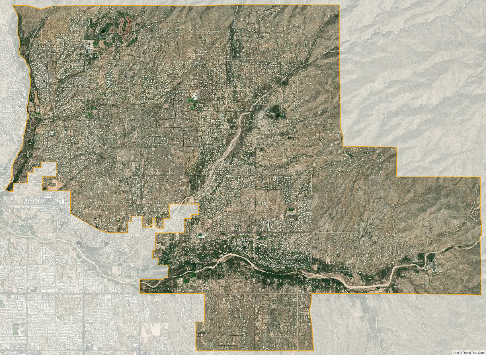
Geography
The Tanque Verde Valley is characterized by the Santa Catalina Mountains to the north, and the Rincon Mountains to the east. The Tanque Verde Valley is traversed by two notable seasonal creeks, Tanque Verde and Agua Caliente.
According to the United States Census Bureau, Tanque Verde has a total area of 32.9 square miles (85.1 km), all land. The river system in Arizona, including in Tanque Verde, is threatened by the increased pumping and diversion of water from the rivers and streams for agriculture, industrial, and domestic use.
See also
Map of Arizona State and its subdivision: Map of other states:- Alabama
- Alaska
- Arizona
- Arkansas
- California
- Colorado
- Connecticut
- Delaware
- District of Columbia
- Florida
- Georgia
- Hawaii
- Idaho
- Illinois
- Indiana
- Iowa
- Kansas
- Kentucky
- Louisiana
- Maine
- Maryland
- Massachusetts
- Michigan
- Minnesota
- Mississippi
- Missouri
- Montana
- Nebraska
- Nevada
- New Hampshire
- New Jersey
- New Mexico
- New York
- North Carolina
- North Dakota
- Ohio
- Oklahoma
- Oregon
- Pennsylvania
- Rhode Island
- South Carolina
- South Dakota
- Tennessee
- Texas
- Utah
- Vermont
- Virginia
- Washington
- West Virginia
- Wisconsin
- Wyoming


