Morristown (/ˈmɒrɪstaʊn/) is a town and the county seat of Morris County, in the U.S. state of New Jersey. Morristown has been called “the military capital of the American Revolution” because of its strategic role in the war for independence from Great Britain. Today this history is visible in a variety of locations throughout the town that collectively make up Morristown National Historical Park, the country’s first National Historical Park.
According to British colonial records, the first permanent settlement at Morristown occurred in 1715, when a settlement was founded as New Hanover by colonists from New York and Connecticut. Morris County was created on March 15, 1739, from portions of Hunterdon County. The county, and ultimately Morristown itself, was named for the popular Governor of the Province, Lewis Morris, who championed land ownership rights for colonists.
Morristown was incorporated as a town by an act of the New Jersey Legislature on April 6, 1865, within Morris Township, and it was formally set off from the township in 1895. As of the 2020 United States census, the town’s population was 20,180, an increase of 1,769 (+9.6%) from the 2010 census count of 18,411, which in turn reflected a decline of 133 (−0.7%) from the 18,544 counted in the 2000 census.
| Name: | Morristown town |
|---|---|
| LSAD Code: | 43 |
| LSAD Description: | town (suffix) |
| State: | New Jersey |
| County: | Morris County |
| Founded: | 1715 |
| Incorporated: | April 6, 1865 |
| Elevation: | 315 ft (96 m) |
| Total Area: | 3.01 sq mi (7.79 km²) |
| Land Area: | 2.91 sq mi (7.53 km²) |
| Water Area: | 0.10 sq mi (0.25 km²) 3.26% |
| Total Population: | 20,180 |
| Population Density: | 6,937.1/sq mi (2,678.4/km²) |
| Area code: | 862/973 |
| FIPS code: | 3448300 |
| GNISfeature ID: | 0885309 |
| Website: | www.townofmorristown.org |
Online Interactive Map
Click on ![]() to view map in "full screen" mode.
to view map in "full screen" mode.
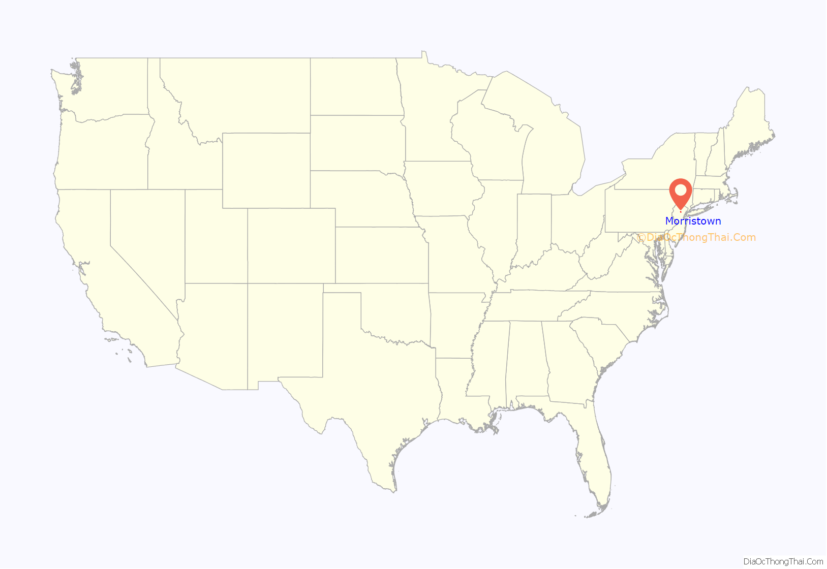
Morristown location map. Where is Morristown town?
History
The area was inhabited by the Lenni Lenape Native Americans for up to 6,000 years prior to exploration of Europeans. The first European settlements in this portion of New Jersey were established by the Swedes and Dutch in the early 17th century, when a significant trade in furs existed between the natives and the Europeans at temporary posts. It became part of the Dutch colony of New Netherland, but the English seized control of the region in 1664, which was granted to Sir George Carteret and John Berkeley, 1st Baron Berkeley of Stratton, as the Province of New Jersey.
Eighteenth century
Morristown was settled around 1715 by English Presbyterians from Southold, New York on Long Island and New Haven, Connecticut as the village of New Hanover. The town’s central location and road connections led to its selection as the seat of the new Morris County shortly after its separation from Hunterdon County on March 15, 1739. The village and county were named for Lewis Morris, the first and then sitting royal governor of a united colony of New Jersey.
By the middle of the 18th century, Morristown had 250 residents, with two churches, a courthouse, two taverns, two schools, several stores, and numerous mills and farms nearby.
George Washington first came to Morristown in May 1773, two years before the Revolutionary War broke out, and traveled from there to New York City together with John Parke Custis (his stepson) and Lord Stirling.
In 1777, General George Washington and the Continental Army marched from the victories at Trenton and Princeton to encamp near Morristown from January to May. Washington had his headquarters during that first encampment at Jacob Arnold’s Tavern, located at the Morristown Green in the center of the town. Morristown was selected for its extremely strategic location. It was between Philadelphia and New York and near New England while being protected by the Watchung Mountains from the bulk of continental British forces camped in New York City. It also was chosen for the skills and trades of the residents, local industries and natural resources to provide arms, and what was thought to be the ability of the community to provide enough food to support the army.
The churches were used for inoculations for smallpox. That first headquarters, Arnold’s Tavern, was eventually moved .5 miles (800 m) south of the green onto Mount Kemble Avenue to become All Souls’ Hospital in the late 19th century. It suffered a fire in 1918, and the original structure was demolished, but new buildings for the hospital were built directly across the street.
From December 1779 to June 1780 the Continental Army’s second encampment at Morristown was at Jockey Hollow. Then, Washington’s headquarters in Morristown was located at the Ford Mansion, a large mansion near what was then the edge of town. Ford’s widow and children shared the house with Martha Washington and officers of the Continental Army.
The winter of 1780 was the worst winter of the Revolutionary War. The starvation was complicated by extreme inflation of money and lack of pay for the army. The entire Pennsylvania contingent successfully mutinied and later, 200 New Jersey soldiers attempted to emulate them (unsuccessfully). Many soldiers died, due to weak health.
During Washington’s second stay, in March 1780, he declared St. Patrick’s Day a holiday to honor his many Irish troops. Martha Washington traveled from Virginia and remained with her husband each winter throughout the war. The Marquis de Lafayette came to Washington in Morristown to inform him that France would be sending ships and trained soldiers to aid the Continental Army.
The Ford Mansion, Jockey Hollow, and Fort Nonsense are all preserved as part of Morristown National Historical Park managed by the National Park Service, which has the distinction among historic preservationists of being the first National Historical Park established in the United States.
During Washington’s stay, Benedict Arnold was court-martialed at Dickerson’s Tavern, on Spring Street, for charges related to profiteering from military supplies at Philadelphia. His admonishment was made public, but Washington quietly promised the hero, Arnold, to make it up to him.
Alexander Hamilton courted and wed Elizabeth Schuyler at a residence where Washington’s personal physician was billeted. Locally known as the Schuyler-Hamilton House, the Dr. Jabez Campfield House is listed on both the New Jersey and National Register of Historic Places.
The Morristown Green has a statue commemorating the meeting of George Washington, the young Marquis de LaFayette, and young Alexander Hamilton depicting them discussing forthcoming aid of French tall ships and troops being sent by King Louis XVI of France to aid the Continental Army.
Morristown’s Burnham Park has a statue of the “Father of the American Revolution”, Thomas Paine, who wrote the pamphlet Common Sense, which urged a complete break from British rule. The bronze statue, by sculptor Georg J. Lober, shows Paine in 1776 (using a drum as a table during the withdrawal of the army across New Jersey) composing Crisis 1. He wrote, “These are the times that try men’s souls…” The statue was dedicated on July 4, 1950.
Nineteenth century
The idea for constructing the Morris Canal is credited to Morristown businessman George P. Macculloch, who in 1822 convened a group to discuss his concept for a canal. The group included Governor of New Jersey Isaac Halstead Williamson, which led to approval of the proposal by the New Jersey Legislature later that year. The canal was used for a century. In July 1825 during his 15 month return tour of the United States, the Marquis de Lafayette returned to Morristown, where a ball was held in his honor at the 1807 Sansay House on DeHart Street (the edifice still stands as of 2011).
In 1827, St. Peter’s Episcopal Church was founded at the behest of Bishop George Washington Doane and many prominent Morristown Families, including George P. Macculloch, of the Morris Canal. When the Church was rebuilt by the then-internationally famous architectural firm, McKim, Mead and White, beginning in 1889, the congregation erected one of the United States finest church buildings –a stone, English-gothic church complete with fined stained glass, and a long, decorated interior.
Antoine le Blanc, a French immigrant laborer, murdered the Sayre family and their servant (or possibly slave), Phoebe. He was tried and convicted of murder of the Sayres (but not of Phoebe) on August 13, 1833. On September 6, 1833, Le Blanc became the last person hanged on the Morristown Green. Until late 2006, the house where the murders were committed was known as “Jimmy’s Haunt,” which is purported to be haunted by Phoebe’s ghost because her murder never saw justice. Jimmy’s Haunt was torn down to make way for a bank in 2007.
Samuel F. B. Morse and Alfred Vail built the first telegraph at the Speedwell Ironworks in Morristown on January 6, 1838. The first telegraph message was A patient waiter is no loser. The first public demonstration of the invention occurred five days later as an early step toward the information age.
Jacob Arnold’s Tavern, the first headquarters for Washington in Morristown and site of Benedict Arnold’s 1780 trial, was purchased by Morristown historian Julia Keese Nelson Colles (1840-1913) to save it from demolition in 1886. It was moved by horse-power in the winter of 1887 from “the green” (after being stuck on Bank Street for about six weeks) to a site 0.5 miles (0.80 km) south on Mount Kemble Avenue at what is now a parking lot for the Atlantic RIMM Rehabilitation Hospital. It became a boarding house for four years until it was converted by the Grey Nuns from Montreal into All Souls’ Hospital, the first general hospital in Morris County. George and Martha Washington’s second floor ballroom became a chapel and the first floor tavern became a ward for patients. In 1910, the late Augustus Lefebvre Revere (brother of hospital founder Paul Revere) willed the Hospital $10,000 to be used for the erection of a new building. This fund was used 8 years later when the original Arnold’s Tavern building was lost to a fire. The entire organization, nurses, doctors, and patients of All Souls’ Hospital were then moved across Mount Kemble Avenue, U.S. Route 202, to the newly built brick hospital building. All Souls’ was set to close because of financial difficulties in the late 1960s. In 1973, it became Community Medical Center. In 1977, the center became bankrupt and was purchased by the then new and larger Morristown Memorial Hospital, which is now the Morristown Medical Center.
On December 18, 1843, the Bethel African Methodist Episcopal Church was incorporated. This was the first congregation established by blacks in Morris County. It is still active. The first site of the Church was located at 13 Spring Street and served as the only schoolhouse for colored children until 1870. The Church relocated to its present site at 59 Spring Street in 1874.
The first Jews moved to Morristown in the 1850s, but much larger numbers of Ashkenazi Jews migrated to the region from Eastern Europe in the 1890s, which led to the incorporation of the Morristown Jewish Center in 1899. Today there are several Jewish synagogues in Morristown reflecting the diversity of the community.
In the 1880s, the town’s residents were primarily farmers. The small amount of stores in the Morristown Green town center were only open during the evening to accommodate farmers who did not leave their work during the daytime. There were only a few stores in town, including Adams & Fairchild grocers and P. H. Hoffman & Son clothiers, both located in the Arnold’s Tavern on the Morristown Green.
Gilded Age of Morristown
Starting in the mid-1800s, Morristown became a popular summer retreat for some of New York City’s wealthiest residents. From the 1870s onwards, immense estates were built up along once rural thoroughfares; Madison Avenue, which runs along Morristown and Madison, New Jersey became known as “the street of the 100 millionaires” due to the sheer extravagance of the houses that were constructed.
Between 1880 and 1929, the Gilded Age of Morristown occurred, when dozens of “millionaires with large fortunes built their estates” in Morristown and Morris Township.
In the 1880 United States census, the town had 5,418 residents, which grew to 8,156 in 1890.
In 1889, Christian charity organization Market Street Mission was established on 9 Market Street beside the Morristown Green in response to the large number of saloons on Market Street. Beginning on March 18, 1889, the Mission hosted nightly meetings to aid and convert those with alcoholism, opioid use, and homelessness. As of 2022, the organization continues to operate a homeless shelter, meals, and emergency services, along with men’s drug addiction recovery groups, community counseling, a chapel, and a thrift store.
The Morris Township describes the influx of millionaires:
This included New York warehouse & grain broker Charles Grant Foster, who bought Union general Joseph Warren Revere’s farm estate and mansion in 1881. This became Fosterfields, a Jersey cow farm. It was later managed by Caroline Rose Foster, though most of its herd was sold in a 1927 auction. In 1979 it was donated to the Morris County Park Commission. The site currently houses a living history museum and Revere’s historic house.
In 1902, the New York Herald described Morristown as “the Millionaire City of the Nation.” The Herald claimed it “contains the richest and least known colony of wealthy people in the world.” It identified 45 millionaires (15 of whom were worth over $10 million) who had purchased country homes in Morristown to avoid “lavish display” and seek “freedom from notoriety.” The newspaper named some of them including lawyer George Griswold Frelinghuysen, carpet-making heir Eugene Higgins, banker Otto Hermann Kahn, Luther Kountze, and Louis A. Thebaud.
Even smaller estates without deer herds, polo fields or private gas plants necessitated “multiple indoor and outdoor employees” such as “butlers, housekeeprs, parlor-maids and upstairs maids; governesses, nannies, and tutors; cooks and kitchen maids, coachmen, grooms, and stable boys; managers, care-takers, watchmen; gardeners and assistants.”
The Gilded Age of Morristown ended in 1929, due to the “high cost of maintaining the estates, increasing income taxes, and the stock market crash” that led to the Great Depression. The Morris Township reports, “Many of the mansions were closed or sold, and some burned.”
20th century to present
Since 1929, more than 16,000 guide dogs for the blind from The Seeing Eye, Inc., the oldest such school in the U.S., have been trained on the streets of Morristown.
On January 5, 2009, five red lights were spotted in the Morristown area night skies, who gained significant press coverage and 9-1-1 calls. On April 1, 2009, the perpetrators revealed their hoax by publicizing footage of its creation, which consisted of helium balloons and flares. The event became nationally known as the Morristown UFO hoax.
Morristown Road Map
Morristown city Satellite Map
Geography
According to the United States Census Bureau, Morristown town had a total area of 3.01 square miles (7.79 km), including 2.91 square miles (7.53 km) of land and 0.10 square miles (0.25 km) of water (3.26%).
Morristown is completely surrounded by Morris Township, making it part of 21 pairs of “doughnut towns” in the state, where one municipality entirely surrounds another.
The downtown shopping and business district of Morristown is centered around a square park, known as the Morristown Green. It is a former market square from Morristown’s colonial days.
Climate
Morristown has a humid continental climate (Köppen climate classification Dfa/Dfb) with hot, humid summers and moderately cold winters.
See also
Map of New Jersey State and its subdivision: Map of other states:- Alabama
- Alaska
- Arizona
- Arkansas
- California
- Colorado
- Connecticut
- Delaware
- District of Columbia
- Florida
- Georgia
- Hawaii
- Idaho
- Illinois
- Indiana
- Iowa
- Kansas
- Kentucky
- Louisiana
- Maine
- Maryland
- Massachusetts
- Michigan
- Minnesota
- Mississippi
- Missouri
- Montana
- Nebraska
- Nevada
- New Hampshire
- New Jersey
- New Mexico
- New York
- North Carolina
- North Dakota
- Ohio
- Oklahoma
- Oregon
- Pennsylvania
- Rhode Island
- South Carolina
- South Dakota
- Tennessee
- Texas
- Utah
- Vermont
- Virginia
- Washington
- West Virginia
- Wisconsin
- Wyoming
