Luke is a town in Allegany County, Maryland, United States, located along the Potomac River just upstream of Westernport. Known originally as West Piedmont, the town is part of the Cumberland, MD-WV Metropolitan Statistical Area. The population was 85 as of the 2020 census.
| Name: | Luke town |
|---|---|
| LSAD Code: | 43 |
| LSAD Description: | town (suffix) |
| State: | Maryland |
| County: | Allegany County |
| Incorporated: | 1922 |
| Elevation: | 961 ft (293 m) |
| Total Area: | 0.31 sq mi (0.79 km²) |
| Land Area: | 0.27 sq mi (0.69 km²) |
| Water Area: | 0.04 sq mi (0.10 km²) |
| Total Population: | 85 |
| Population Density: | 319.55/sq mi (123.25/km²) |
| ZIP code: | 21540 |
| Area code: | 301, 240 |
| FIPS code: | 2448775 |
| GNISfeature ID: | 0590707 |
Online Interactive Map
Click on ![]() to view map in "full screen" mode.
to view map in "full screen" mode.
Luke location map. Where is Luke town?


History
The town of Luke was settled in the early 1770s after the organization of Hampshire County, West Virginia (at that time part of Virginia) in 1757. Among the first settlers to arrive were the Davis brothers (Henry and Thomas), who established a saw mill where the town of Luke now stands. The mill provided cross-ties to the Baltimore and Ohio Railroad as it pushed its rails westward through the Piedmont area of what is now West Virginia.
When the railroad suspended building in the 1880s, the Davis brothers disbanded and sold their property to William Luke, who founded the Piedmont Pulp and Paper Company there with his sons in 1888. With this and other paper mills they had built in West Virginia and Maryland, they formed the West Virginia Pulp and Paper Company in 1897. When the railroad needed a name for the stop it established near the site, it used the name “Luke”.
The land on which Luke was built was originally an island formed by a split in the Potomac River. It was known as West Piedmont and claimed by Piedmont, West Virginia until the river’s path changed and the land reverted to Maryland.
Over the next several decades, Luke prospered with the operation of the paper mill, the influx of other “heavy” industrial concerns, and the establishment of the usual supporting mom-and-pop businesses. Nearby, along the Savage River, there was a gun factory that provided muskets with bayonets for the United States Army at Harpers Ferry. Luke was also home of an automobile manufacturing plant where the Maryland Steamer was produced, as well as a post card factory.
With Luke’s growth came citizens’ concerns about educational and social issues. Schooling in private homes and business buildings was relocated to a two-room schoolhouse. Growing enrollment in the first through eighth grades brought about construction of a new school that opened in September 1913. It served the town for forty-six years, sending its students off to Bruce High School in Westernport. When the school closed in 1959, the building was converted for use as the town’s administrative offices.
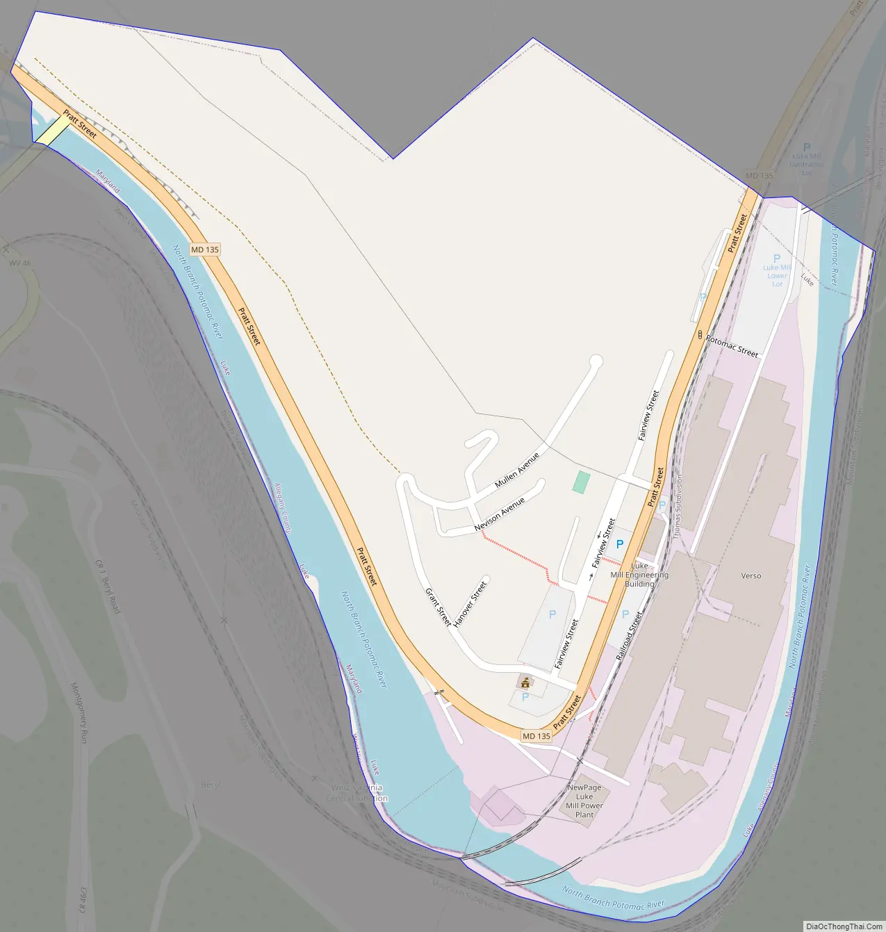
Luke Road Map
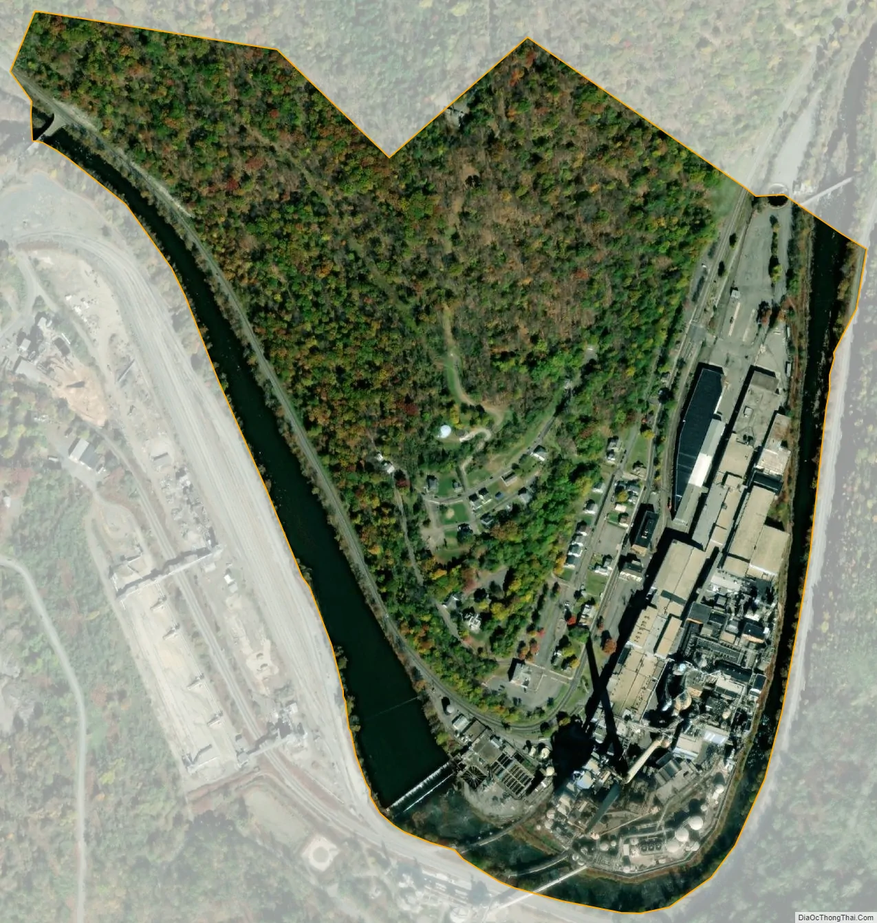
Luke city Satellite Map
Geography
Luke sits on the inside of a bend in the Potomac between Westernport and Bloomington, Maryland. According to the United States Census Bureau, the town has a total area of 0.31 square miles (0.80 km), of which 0.27 square miles (0.70 km) is land and 0.04 square miles (0.10 km) is water.
See also
Map of Maryland State and its subdivision: Map of other states:- Alabama
- Alaska
- Arizona
- Arkansas
- California
- Colorado
- Connecticut
- Delaware
- District of Columbia
- Florida
- Georgia
- Hawaii
- Idaho
- Illinois
- Indiana
- Iowa
- Kansas
- Kentucky
- Louisiana
- Maine
- Maryland
- Massachusetts
- Michigan
- Minnesota
- Mississippi
- Missouri
- Montana
- Nebraska
- Nevada
- New Hampshire
- New Jersey
- New Mexico
- New York
- North Carolina
- North Dakota
- Ohio
- Oklahoma
- Oregon
- Pennsylvania
- Rhode Island
- South Carolina
- South Dakota
- Tennessee
- Texas
- Utah
- Vermont
- Virginia
- Washington
- West Virginia
- Wisconsin
- Wyoming


