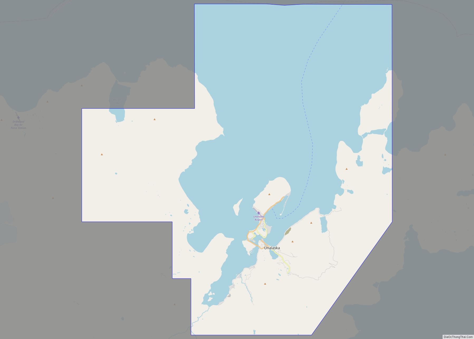
The City of Unalaska (Aleut: Iluulux̂; Russian: Уналашка) is the main population center in the Aleutian Islands. The city is in the Aleutians West Census Area, a regional component of the Unorganized Borough in the U.S. state of Alaska. Unalaska is located on Unalaska Island and neighboring Amaknak Island in the Aleutian Islands off mainland Alaska. The population was 4,254 at the 2020 census, which is 81% of the entire Aleutians West Census Area. Unalaska is the second largest city in the Unorganized Borough, behind Bethel.
The Aleut (Unangan) people have lived on Unalaska Island for thousands of years. The Unangan, who were the first to inhabit the island of Unalaska, named it “Ounalashka”, meaning “near the peninsula”. The regional native corporation has adopted this moniker, and is known as the Ounalashka Corporation. The Russian fur trade reached Unalaska when Stepan Glotov and his crew arrived on August 1, 1759. Natives, Russians and their Alaskan Creole descendants comprised most of the community’s population until the mid-20th century, when the involvement of the United States in World War II led to a large-scale influx of people and construction of buildings all along the strategically located Aleutians.
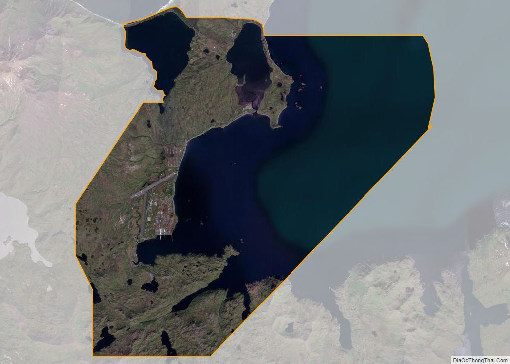
Almost all of the community’s port facilities are on Amaknak Island, better known as Dutch Harbor or just “Dutch”. It is the largest fisheries port in the U.S. by volume caught. It includes Dutch Harbor Naval Operating Base and Fort Mears, U.S. Army, a U.S. National Historic Landmark. Dutch Harbor lies within the city limits of Unalaska and is connected to Unalaska by a bridge. Amaknak Island is home to almost 59 percent of the city’s population, although it has less than 3 percent of its land area.
As a result of the town’s strong fishing industry, Unalaska has also become notable for its large population of bald eagles, which number in the hundreds and were attracted to the area by human activity.
| Name: | Unalaska city |
|---|---|
| LSAD Code: | 25 |
| LSAD Description: | city (suffix) |
| State: | Alaska |
| County: | Aleutians West Census Area |
| Incorporated: | March 3, 1942 |
| Elevation: | 13 ft (4 m) |
| Total Area: | 210.89 sq mi (546.20 km²) |
| Land Area: | 102.21 sq mi (264.73 km²) |
| Water Area: | 108.68 sq mi (281.47 km²) |
| Total Population: | 4,254 |
| Population Density: | 41.62/sq mi (16.07/km²) |
| ZIP code: | 99685 |
| Area code: | 907 |
| FIPS code: | 0280770 |
| GNISfeature ID: | 1419424 |
| Website: | www.ci.unalaska.ak.us |
Online Interactive Map
Click on ![]() to view map in "full screen" mode.
to view map in "full screen" mode.
Unalaska location map. Where is Unalaska city?

History
The island of Unalaska was first inhabited by the Aleut people.
Unalaska and Amaknak Islands contained 24 settlements with more than 1,000 Aleut inhabitants in 1759, when the first Russian group under Stepan Glotov came and started trading for three years on Umnak and Unalaska. Between 1763 and 1766, a conflict between the Russian fur traders and the Unalaska Natives occurred; the Aleuts destroyed four Russian ships and killed 175 hunters/traders. In the 1760s, Unalaska was temporarily used as a Russian fur trading post. The post was permanently established in 1774, and was eventually incorporated into the Russian-American Company. It was there that Captain James Cook encountered the navigator Gerasim Izmailov in 1778.
In 1788, the Spanish made contact with the Russians in Alaska for the first time. An expedition by Esteban José Martínez and Gonzalo López de Haro visited several Russian settlements. Their westernmost visit was to Unalaska. On August 5, 1788, they claimed Unalaska for Spain, calling it Puerto de Dona Marie Luisa Teresa.
Alexander Andreyevich Baranov was shipwrecked here in 1790.
In 1825, the Russian Orthodox Church of the Holy Ascension was built in Unalaska. The founding priest, Ivan Veniaminov, later canonized as Saint Innocent of Alaska, composed the first Aleut writing system with local assistance, and translated scripture into Aleut. Between 1836 and 1840, measles, chicken-pox and whooping-cough epidemics drastically reduced the population; thus, at the end of the decade, only 200 to 400 Aleuts lived in Unalaska.
On October 18, 1867, the United States purchased Alaska, making Unalaska part of the U.S. territory.
In 1880, the Methodist Church opened a school and a clinic for orphans in Unalaska. Between 1899 and 1905, the Gold Rush brought many ships through Dutch Harbor where the North American Commercial Company had a coaling station.
During the first half of the century, the island was touched by numerous epidemics, first in 1900, and then in 1919 the Spanish flu touched the island: these contributed to a dramatic decrease of the population in Unalaska.
Fearing the threat from Imperial Japan during World War II, the then neutral United States started fortifying Dutch Harbor in 1940, resulting in the construction of the Dutch Harbor Naval Operating Base and Fort Mears that was finished entirely by September 1941 three months before the surprise attack on Pearl Harbor that caused the U.S. to enter the war. On June 3, 1942, the town was attacked by Japanese air forces in the Battle of Dutch Harbor, part of the Aleutian Islands Campaign. After the attack and the Japanese occupations of Kiska and Attu, almost all of the native residents of Amaknak Island were evacuated. Many were held, under poor conditions, in camps in Southeast Alaska for the duration of the war; a substantial number of the internees died during the imprisonment.
Beginning in the 1950s, Unalaska became a center of the Alaskan king crab fishing industry; by 1978 it was the largest fishing port in the United States. A 1982 crash in king crab harvests decimated the industry, and the mid-1980s saw a transition to bottom fishing.
On October 25, 1977, an extremely intense extratropical system struck the area. A pressure of 926 millibars was recorded at Dutch Harbor, which was the lowest non-tropical pressure ever recorded in the United States until December 31, 2020 when another system struck the islands with a pressure of 924.8 millibars.
Recent history
The city has struggled with problems like alcoholism and unemployment in the past and still does, although the situation has improved in recent years. One example is the Elbow Room, a bar which locally, and later abroad, became infamous for its raucousness. It was closed in 2005.
Since 2005, the Discovery Channel’s documentary show Deadliest Catch has focused on fishermen who are based in Dutch Harbor.
Unalaska Road Map

Unalaska city Satellite Map

Geography
According to the U.S. Census Bureau, the city has a total area of 212.3 square miles (549.9 km), of which 111.0 square miles (287.5 km) is land and 101.3 square miles (262.4 km) (47.71%) is water.
Makushin Volcano (5,691 ft/1,735 m) is located on the island; it is not quite visible from within the town of Unalaska, though the steam rising from its cone is visible on the rare clear day. By climbing one of the smaller hills in the area, such as Pyramid Peak or Mount Newhall, it is possible to get a good look at the snow-covered cone.
Paleontology
A major find was announced in 2015 after scientists examined a group of giant, tusked, quadruped, marine mammal fossils. The species had been unearthed during excavation for the construction of a school. They are unique, shore dwellers belonging to the extinct order Desmostylia, and possibly related to Proboscidea or Sirenia. A rendition of a group was drawn by Alaskan artist Ray Troll.
Climate
As in all of the Aleutian islands in the south of Akutan Island (32 °F or 0 °C isotherm) the climate of Unalaska is a subpolar oceanic climate (Cfc), closely bordering a subarctic climate (Dfc) following the trend of warming have predominates the first one. Even so, other climatic maps present even in group D in the Köppen Classification (even though all months average above freezing), with moderate and fairly uniform temperatures and heavy precipitation. Winters are consistently cold, but relatively mild in comparison to other parts of the state. Summers are cool, with most afternoons only reaching highs of 54 °F (12 °C) to 70 °F (21 °C). Fog is often present even when it is not raining. Summer weather is around 5 °F (2.8 °C) cooler than Southeast Alaska (Sitka), but the winter temperatures are nearly the same, although despite the higher latitudes of cities such as Sitka and Ketchikan, both of the two cities have warmer winters than Unalaska.
The mean annual temperature for Unalaska is about 41.6 °F (5.3 °C), being about 33.0 °F (0.6 °C) in January and about 53.7 °F (12.1 °C) in August. The coldest month has been February 1984 with a mean temperature of 22.9 °F (−5.1 °C), while the warmest month was August 2019 at 57.3 °F (14.1 °C); the annual mean temperature has ranged from 38.0 °F (3.3 °C) in 1916 to 44.1 °F (6.7 °C) in 2016. With about 225 rainy days a year, Unalaska is among the rainiest places in the United States. June through August are markedly the driest months of the year, with very rare thunderstorms. Precipitation is especially heavy from October to February, when frequent, often-intense storms from the North Pacific Ocean cross the area, bringing high to very high winds and heavy precipitation in any form, and sometimes, changing forms (rain, freezing rain, sleet, snow). On average, December is the year’s wettest month. Snowfall averages over 81 inches (210 cm) per winter season, and can be heavy from December to March.
Unalaska’s recorded temperature range is from 82 °F (28 °C) in August 1982 to −8 °F (−22 °C) in January 1986. The coldest daytime maximum recorded is 11 °F (−12 °C) and the annual mean coldest day is 24 °F (−4 °C). The warmest night on record is well above the average daily summer high temperature, standing at 65 °F (18 °C), with the mean for the annual warmest night being 56 °F (13 °C).
Note
- ^ Mean monthly maxima and minima (i.e. the highest and lowest temperature readings during an entire month or year) calculated based on data at said location from 1991 to 2020.
See also
Map of Alaska State and its subdivision:- Aleutians East
- Aleutians West
- Anchorage
- Bethel
- Bristol Bay
- Denali
- Dillingham
- Fairbanks North Star
- Haines
- Juneau
- Kenai Peninsula
- Ketchikan Gateway
- Kodiak Island
- Lake and Peninsula
- Matanuska-Susitna
- Nome
- North Slope
- Northwest Arctic
- Prince of Wales-Outer Ketchi
- Sitka
- Skagway-Yakutat-Angoon
- Southeast Fairbanks
- Valdez-Cordova
- Wade Hampton
- Wrangell-Petersburg
- Yukon-Koyukuk
- Alabama
- Alaska
- Arizona
- Arkansas
- California
- Colorado
- Connecticut
- Delaware
- District of Columbia
- Florida
- Georgia
- Hawaii
- Idaho
- Illinois
- Indiana
- Iowa
- Kansas
- Kentucky
- Louisiana
- Maine
- Maryland
- Massachusetts
- Michigan
- Minnesota
- Mississippi
- Missouri
- Montana
- Nebraska
- Nevada
- New Hampshire
- New Jersey
- New Mexico
- New York
- North Carolina
- North Dakota
- Ohio
- Oklahoma
- Oregon
- Pennsylvania
- Rhode Island
- South Carolina
- South Dakota
- Tennessee
- Texas
- Utah
- Vermont
- Virginia
- Washington
- West Virginia
- Wisconsin
- Wyoming