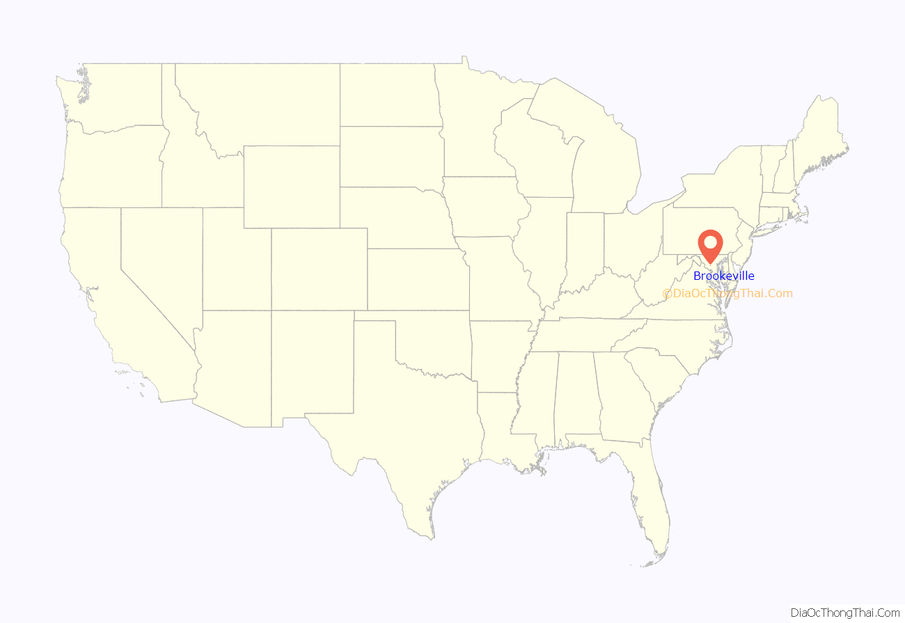
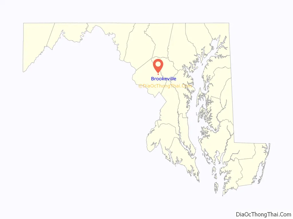
Brookeville is a town in Montgomery County, Maryland, United States, located 20 km (12 mi) north of Washington, D.C., and 2 km (1.2 mi) north of Olney. Brookeville was settled by Quakers late in the 18th century and was formally incorporated as a town in 1808. Historically part of the local agricultural industry, Brookeville has developed rapidly into a suburban community of Washington, D.C. since the 1950s following the construction of the Georgia Avenue toll road. The population was 134 at the 2010 census.
Brookeville is notable as the “United States Capital for a Day” during the War of 1812, when British troops burned Washington D.C., and President James Madison sought refuge in Brookeville on August 26, 1814. During the American Civil War, Brookeville, along with nearby Sandy Spring, was a stop on the Underground Railroad.
| Name: | Brookeville town |
|---|---|
| LSAD Code: | 43 |
| LSAD Description: | town (suffix) |
| State: | Maryland |
| County: | Montgomery County |
| Incorporated: | 1808 |
| Elevation: | 436 ft (133 m) |
| Total Area: | 0.14 sq mi (0.36 km²) |
| Land Area: | 0.14 sq mi (0.36 km²) |
| Water Area: | 0.00 sq mi (0.00 km²) |
| Total Population: | 166 |
| Population Density: | 1,185.71/sq mi (459.09/km²) |
| ZIP code: | 20833 |
| Area code: | 301, 240 |
| FIPS code: | 2410225 |
| GNISfeature ID: | 0589824 |
| Website: | townofbrookevillemd.org |
Online Interactive Map
Click on ![]() to view map in "full screen" mode.
to view map in "full screen" mode.
Brookeville location map. Where is Brookeville town?
History
Quakers Richard Thomas and his wife Deborah Brooke founded the town of Brookeville in 1794, and named it after her family. The town was established on land inherited by Deborah Brooke from her father Roger Brooke IV, son of an influential Quaker landholder, James Brooke. At the time, Brooke was the largest landholder in what would become Montgomery County. Thomas also set up a mill, along the Reddy Branch, which cuts through the town. Caleb Bentley opened a store and a post office in 1802, becoming the first postmaster of Brookeville. The town’s charter was approved in 1808, though not formally issued until 1890.
Brookeville served as a market town for the agriculture industry in the surrounding area. During the 19th century, Brookeville was home to several mills, the Brookeville Academy (initially a boys’ school), a post office, blacksmith’s shop, St. Luke’s Episcopal Church, Salem Methodist Protestant Church, and a number of shops. Newlin’s Mill, located on the west side of town, processed high-quality castor oil and ground limestone for plaster. Thomas Mill was located on the east side of town. To transport goods more easily to markets in Washington, D.C., a prosperous farmer established a company in 1849 to build a toll road to connect Brookeville to the Seventh Street Pike. The turnpike was sold to the State of Maryland in 1914, and later became Georgia Avenue.
Brookeville was also home to Thomas Moore, Jr. who, along with Caleb Bentley, was instrumental in creation of the United States Department of Agriculture. Moore is also credited as the inventor of the first refrigerator, and coining the term. He created a portable contraption to transport butter and other products to sell at markets in Washington, D.C. His products commanded a high price, due to the extra freshness of the products at the market. Moore lived near the town, at Longwood Manor, which was built in 1817.
War of 1812
During the War of 1812, when the British burned parts of Washington, D.C., the Federal government and troops fled the capital. President James Madison first fled to Virginia, but then turned north. He arrived in Rockville at 6 p.m. on August 26, 1814, expecting to find General William H. Winder and his troops. They had already proceeded on towards Baltimore. Madison continued on eastward and arrived in Brookeville on horseback. Madison reportedly carried with him a strongbox, which contained the entire U.S. treasury. On the night of August 26, he stayed in the home of Caleb Bentley, whose wife Henrietta Thomas was close friends with Dolley Madison.
Madison stayed up all night, dispatching orders, while soldiers remained on guard outside. After the British left Washington, they sailed to nearby Baltimore, where they attacked Fort McHenry and were repulsed. Upon hearing that news, Madison returned to Washington. Madison wrote a note to his wife that morning.
Late 19th century
The Oakley Farm, located on the western edge of Brookeville, thrived during the 18th and 19th centuries. Log cabins, dating from the 1820s, were built on the Oakley/Dorsey farm, to house slaves and later free black families. The Oakley Cabin is now maintained by the Montgomery County Department of Parks. A number of other 18th and 19th century cabins still exist on private property in the Brookeville area.
During the American Civil War, George B. McClellan sent Union troops (First and the Ninth Corps) through Brookeville, on their way to Antietam. This was one of three groups of troops that came from different directions towards Antietam. The Quakers played an instrumental role in aiding escaped slaves on the underground railroad. Nearby Sandy Spring was an important stop. Historians suggest that the Madison House was also used as a stop on the underground railroad during the Civil War. Part of the Madison House once served as the town’s post office. A false stone wall in the room hid a staircase that descended in two directions, including into a hidden area in the basement where escaped slaves could hide.
20th century
In 1910, the Salem United Methodist Church was built to replace another church that was destroyed by fire, and the church cemetery has been there since the mid-19th century. By 1900, the mills and shops had shut down, and Brookeville remained a residential town. In 1915, the Bentley family sold the Madison House to Roger Brooke, a leader of the Quaker community. The house later changed hands, owned for some time by Elisha Hall, a principal at the Brookeville Academy, banker Remus Riggs, and Gene Archer, an NBC television personality.
The automobile gave people more mobility and changed the market, with the nearby town of Olney taking prominence over Brookeville. Since the 1950s, Olney has rapidly developed, putting pressure on the community. The Brookeville Historic District was placed on the National Register of Historic Places in 1979. Brookeville’s historic designation has helped it retain historic character.
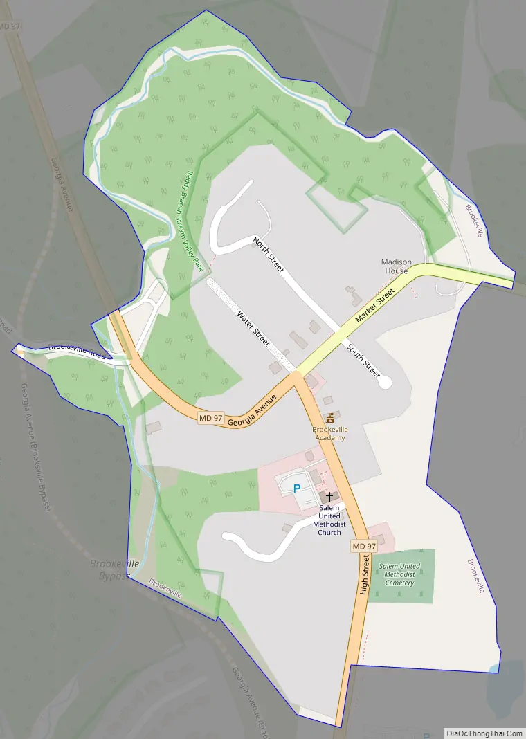
Brookeville Road Map
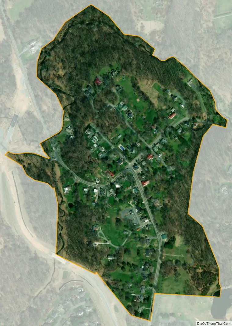
Brookeville city Satellite Map
Geography
Brookeville is located in northeastern Montgomery County, Maryland, close to the Patuxent River and the Howard County border. The town is located 2 miles (3.2 km) north of Olney. The Town of Brookeville is formally incorporated, and covers an area of 0.1 square miles (0.26 km). Areas beyond the formal town boundaries, extending to the Howard County boundary, are defined as Brookeville by the USPS, all falling within the 20833 ZIP Code. Located within the ZIP Code are the small hamlets of Sunshine and Brighton. Georgia Avenue, which is a major north–south route through this part of Maryland, passes through the Town of Brookeville. Brookeville Road connects the town with Laytonsville and other areas to the west. Brighton Dam Road extends to the east, crossing New Hampshire Avenue, over the Patuxent River, and into Howard County.
Georgia Avenue, which begins in Washington, D.C., is a two-lane road when it passes through the Town of Brookeville, with a stop sign and tight turn that takes it through the historic district. In 1989, the road carried 8,000 vehicles daily, a number which had increased to 18,000 vehicles each weekday as of 2007. The traffic mainly consists of commuters from Carroll County and Howard County. The traffic volume on Georgia Avenue is more than the road was designed to handle. Brookeville residents have advocated for a bypass road to be constructed, to take traffic around the town. The bypass road around the town was in the planning stages for some time, since being recommended by county planning officials in 1966. The bypass road will include two roundabouts, one on either side of the town. The project is under construction as of May 2019 and is anticipated to be completed by summer 2021.
Reddy Branch, a tributary of the Hawlings River, flows along the north and eastern edges of the town. Reddy Branch Stream Valley Park is located along Brookeville Road, to the west of the town, and to the east along Brighton Dam Road. Hawling Hills Park and Patuxent River State Park are located along New Hampshire Avenue, north of Ashton and to the east of Brookeville. Patuxent River State Park is used for hunting, fishing, hiking and horseback riding. Rachel Carson Conservation Park, located to the north, between Brookeville and Laytonsville, is undeveloped and has a number of hiking trails. The Triadelphia Reservoir, created by the Brighton Dam, is located on the Patuxent River. The Washington Suburban Sanitary Commission maintains 6,000 acres (24 km), in and around the reservoir, which are open to the public for recreational purposes. The Reservoir is a popular recreation spot that is suitable for fishing, kayaking, and other activities. Mount Zion Park is a small park with playgrounds, ball fields, tennis courts, and picnic facilities. Within the town itself, Powers’ Woods Park is a new 2-acre (8,100 m) park that is slated to be located near a recently restored one-room schoolhouse.
According to the United States Census Bureau, the town has a total area of 0.12 square miles (0.31 km), all land.
Climate
The climate in this area is characterized by hot, humid summers and generally mild to cool winters. According to the Köppen Climate Classification system, Brookeville has a humid subtropical climate, abbreviated “Cfa” on climate maps.
See also
Map of Maryland State and its subdivision: Map of other states:- Alabama
- Alaska
- Arizona
- Arkansas
- California
- Colorado
- Connecticut
- Delaware
- District of Columbia
- Florida
- Georgia
- Hawaii
- Idaho
- Illinois
- Indiana
- Iowa
- Kansas
- Kentucky
- Louisiana
- Maine
- Maryland
- Massachusetts
- Michigan
- Minnesota
- Mississippi
- Missouri
- Montana
- Nebraska
- Nevada
- New Hampshire
- New Jersey
- New Mexico
- New York
- North Carolina
- North Dakota
- Ohio
- Oklahoma
- Oregon
- Pennsylvania
- Rhode Island
- South Carolina
- South Dakota
- Tennessee
- Texas
- Utah
- Vermont
- Virginia
- Washington
- West Virginia
- Wisconsin
- Wyoming


