Nenana /nɛˈnænə/ (Lower Tanana: Toghotili; is a home rule city in the Yukon-Koyukuk Census Area of the Unorganized Borough in the Interior of the U.S. state of Alaska. Nenana developed as a Lower Tanana community at the confluence where the tributary Nenana River enters the Tanana. The population was 378 at the 2010 census, down from 402 in 2000.
Completed in 1923, the 700-foot-long (210 m) Mears Memorial Bridge was built over the Tanana River as part of the territory’s railroad project connecting Anchorage and Fairbanks.
| Name: | Nenana city |
|---|---|
| LSAD Code: | 25 |
| LSAD Description: | city (suffix) |
| State: | Alaska |
| County: | Yukon-Koyukuk Census Area |
| Incorporated: | November 17, 1921 |
| Elevation: | 351 ft (107 m) |
| Total Area: | 6.25 sq mi (16.18 km²) |
| Land Area: | 5.95 sq mi (15.42 km²) |
| Water Area: | 0.29 sq mi (0.76 km²) |
| Total Population: | 358 |
| Population Density: | 60.14/sq mi (23.22/km²) |
| ZIP code: | 99760 |
| Area code: | 907 |
| FIPS code: | 0253050 |
| GNISfeature ID: | 1406940 |
Online Interactive Map
Click on ![]() to view map in "full screen" mode.
to view map in "full screen" mode.
Nenana location map. Where is Nenana city?

History
Nenana is in the westernmost portion of Tanana territory. (The Tanana are among the large Dené language family, also known as Athabascan.) The town was first known by European Americans as Tortella, a transliteration of the Indian word Toghotthele, which means “mountain that parallels the river.” It was later named for the river and the Nenana people who live nearby. The Nenana people became accustomed to contact with Europeans, due to trading journeys to the Village of Tanana, where Russians bartered Western goods for furs from 1838.
The United States purchased Alaska from Russia in 1867. Early American explorers and traders, such as Henry Tureman Allen, Arthur Harper and Bates, first entered the Tanana Valley in 1874 and 1885.
In 1902 the discovery of gold in Fairbanks brought intense activity to the region. The next year, Jim Duke built a trading post/roadhouse to supply river travelers and trade with the Nenana community.
In 1905 the Episcopal Church, which had missionaries in Alaska, built the St. Mark’s Episcopal mission and Tortella School a short distance upriver. The boarding school taught about 28 children of various ages at a time. Hudson Stuck, the Archdeacon of the Yukon, regularly visited the settlement, part of the 250,000 square-acre territory of the Interior he administered. Native children from other communities, such as Minto, also attended school in Nenana.
A post office opened in 1908. In 1915, construction of the Alaska Railroad brought new settlers, who doubled Nenana’s population. The railroad connected Nenana to the southern port city of Anchorage. The community incorporated as a city in 1921.
The Railroad Depot was completed in 1923. That year, United States President Warren Harding arrived to drive the final, golden spike at the north end of the 700-foot-long (210 m) Mears Memorial Bridge built over the Tanana River as part of the state’s railroad project.
This railroad truss bridge, the longest in the United States and its territories when completed, gave Nenana a rail transportation link north to Fairbanks and Seward, Alaska. The bridge still ranks as the longest span in Alaska and the third-longest truss bridge in the United States.
The construction had encouraged businesses and settlement in town. According to local records, 5,000 residents lived in Nenana by the early 1920s. After the railroad was completed, however, contractors and construction workers left the area. The city suffered an economic slump, and most of the residents migrated to seek work in other places. By 1930, the population had dropped to 291.
Nenana was the starting point for the 1925 serum run to Nome, after diphtheria antitoxin had been transported by rail from Anchorage. It was carried by dog sled to Nome to treat people in an epidemic.
In 1961, Clear Air Force Station was constructed 21 miles southwest. During this construction, many civilian contractors commuted from Nenana. A road was constructed south to Clear, but northbound vehicles had to be ferried across the Tanana River.
In 1967 the community was devastated by one of the largest floods ever recorded in the valley. In 1968 a $6 million bridge for vehicles was completed across the Tanana River, which gave the town a modern road link to Fairbanks and replaced the river ferry. The George Parks Highway was completed in 1971, providing a shorter, direct route to Anchorage.
The federally recognized tribe in the community is the Nenana Native Association, who traditionally spoke the Lower Tanana language. Under the Alaska Native Claims Settlement Act of 1971, they have rights of self-government and managing some of their traditional territory. According to the 2000 Census, 41% of the city residents were Native American (or Alaska Natives).
Residents of Nenana sponsor the Nenana Ice Classic, a nature-based lottery. Entrants buy a ticket and pick a date in April or May and a time, to the closest minute, when they think the winter ice on the Tanana River will break up. This lottery began in 1917 among a group of surveyors working for the Alaska Railroad. They formed a betting pool as they waited for the river to open and boats to arrive with needed supplies.
The competition is run as follows: a large striped tripod is placed on the frozen Tanana River and connected to a clock. The winner is whoever comes closest to guessing the precise time when the ice beneath weakens to the point that the tripod moves and stops the clock. Interest in the pool has increased and attracts bettors statewide. This lottery has paid out nearly $10 million in prize money, with the winning pool in recent years being near $300,000.
In the summer of 2008, Nenana suffered heavy damage due to flooding. The Tanana River reached its second-highest level since written record keeping began.
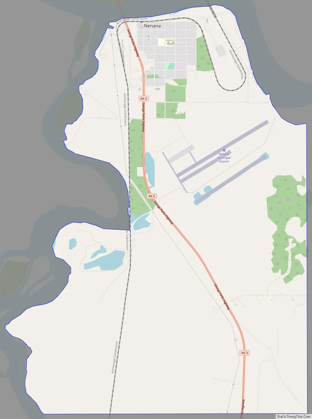
Nenana Road Map
Nenana city Satellite Map

Geography
Nenana is located at 64°33′50″N 149°5′35″W / 64.56389°N 149.09306°W / 64.56389; -149.09306, (Sec. 14, T004S, R008W, Fairbanks Meridian) in the Nenana Recording District.
According to the United States Census Bureau, the city has a total area of 6.1 square miles (16 km), of which, 6.0 square miles (16 km) of it is land and 0.1 square miles (0.26 km) of it (0.99%) is water.
Nenana is located 55 road miles southwest of Fairbanks on the George Parks Highway and 304 road miles north of Anchorage. It is at mile 412 of the Alaska Railroad. The river is ice-free from early May to late October.
Nenana has a transitional humid continental/subarctic climate (Köppen Dfb/Dfc) with long, cold and dry winters and warm summers with cool nights.
See also
Map of Alaska State and its subdivision:- Aleutians East
- Aleutians West
- Anchorage
- Bethel
- Bristol Bay
- Denali
- Dillingham
- Fairbanks North Star
- Haines
- Juneau
- Kenai Peninsula
- Ketchikan Gateway
- Kodiak Island
- Lake and Peninsula
- Matanuska-Susitna
- Nome
- North Slope
- Northwest Arctic
- Prince of Wales-Outer Ketchi
- Sitka
- Skagway-Yakutat-Angoon
- Southeast Fairbanks
- Valdez-Cordova
- Wade Hampton
- Wrangell-Petersburg
- Yukon-Koyukuk
- Alabama
- Alaska
- Arizona
- Arkansas
- California
- Colorado
- Connecticut
- Delaware
- District of Columbia
- Florida
- Georgia
- Hawaii
- Idaho
- Illinois
- Indiana
- Iowa
- Kansas
- Kentucky
- Louisiana
- Maine
- Maryland
- Massachusetts
- Michigan
- Minnesota
- Mississippi
- Missouri
- Montana
- Nebraska
- Nevada
- New Hampshire
- New Jersey
- New Mexico
- New York
- North Carolina
- North Dakota
- Ohio
- Oklahoma
- Oregon
- Pennsylvania
- Rhode Island
- South Carolina
- South Dakota
- Tennessee
- Texas
- Utah
- Vermont
- Virginia
- Washington
- West Virginia
- Wisconsin
- Wyoming


