Hartford is the capital city of the U.S. state of Connecticut. It was the seat of Hartford County until Connecticut disbanded county government in 1960. It is the largest city in the Capitol Planning Region, and core city of the Greater Hartford metropolitan area. Census estimates since the 2010 United States census have indicated that Hartford is the fourth-largest city in Connecticut with a 2020 population of 121,054, behind the coastal cities of Bridgeport, New Haven, and Stamford.
Hartford was founded in 1635 and is among the oldest cities in the United States. It is home to the country’s oldest public art museum (Wadsworth Atheneum), the oldest publicly funded park (Bushnell Park), the oldest continuously published newspaper (the Hartford Courant), and the second-oldest secondary school (Hartford Public High School). It was home to the oldest “asylum for the deaf and dumb” the (American School for the Deaf), founded by Thomas Hopkins Gallaudet in 1817. It is also home to the Mark Twain House, where the author wrote his most famous works and raised his family, among other historically significant sites. Mark Twain wrote in 1868, “Of all the beautiful towns it has been my fortune to see this is the chief.”
Hartford has been the sole capital of Connecticut since 1875. Before then, New Haven and Hartford alternated as dual capitals, as part of the agreement by which the Colony of New Haven was absorbed into the Colony of Connecticut in 1664.
Hartford was the richest city in the United States for several decades following the American Civil War. Since 2015, it has been one of the poorest cities in the country, with three out of ten families living below the poverty threshold. In sharp contrast, the Greater Hartford metropolitan statistical area was ranked 32nd of 318 metropolitan areas in total economic production and 8th out of 280 metropolitan statistical areas in per capita income in 2015.
Nicknamed the “Insurance Capital of the World”, the city holds high sufficiency as a global city, as home to the headquarters of many insurance companies, the region’s major industry. Other prominent industries include the services, education and healthcare industries. Hartford coordinates certain Hartford-Springfield regional development matters through the Knowledge Corridor Economic Partnership.
| Name: | Hartford city |
|---|---|
| LSAD Code: | 25 |
| LSAD Description: | city (suffix) |
| State: | Connecticut |
| County: | Hartford County |
| Elevation: | 30 ft (9 m) |
| Land Area: | 17.38 sq mi (45.01 km²) |
| Water Area: | 0.68 sq mi (1.75 km²) |
| Population Density: | 6,965.1/sq mi (2,689.5/km²) |
| Area code: | 860/959 |
| FIPS code: | 0937000 |
| GNISfeature ID: | 2378277 |
| Website: | www.hartford.gov |
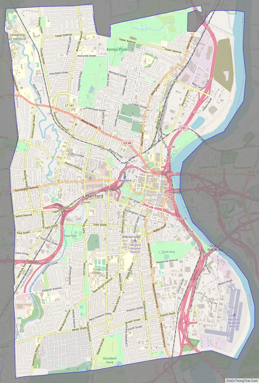
Online Interactive Map
Click on ![]() to view map in "full screen" mode.
to view map in "full screen" mode.
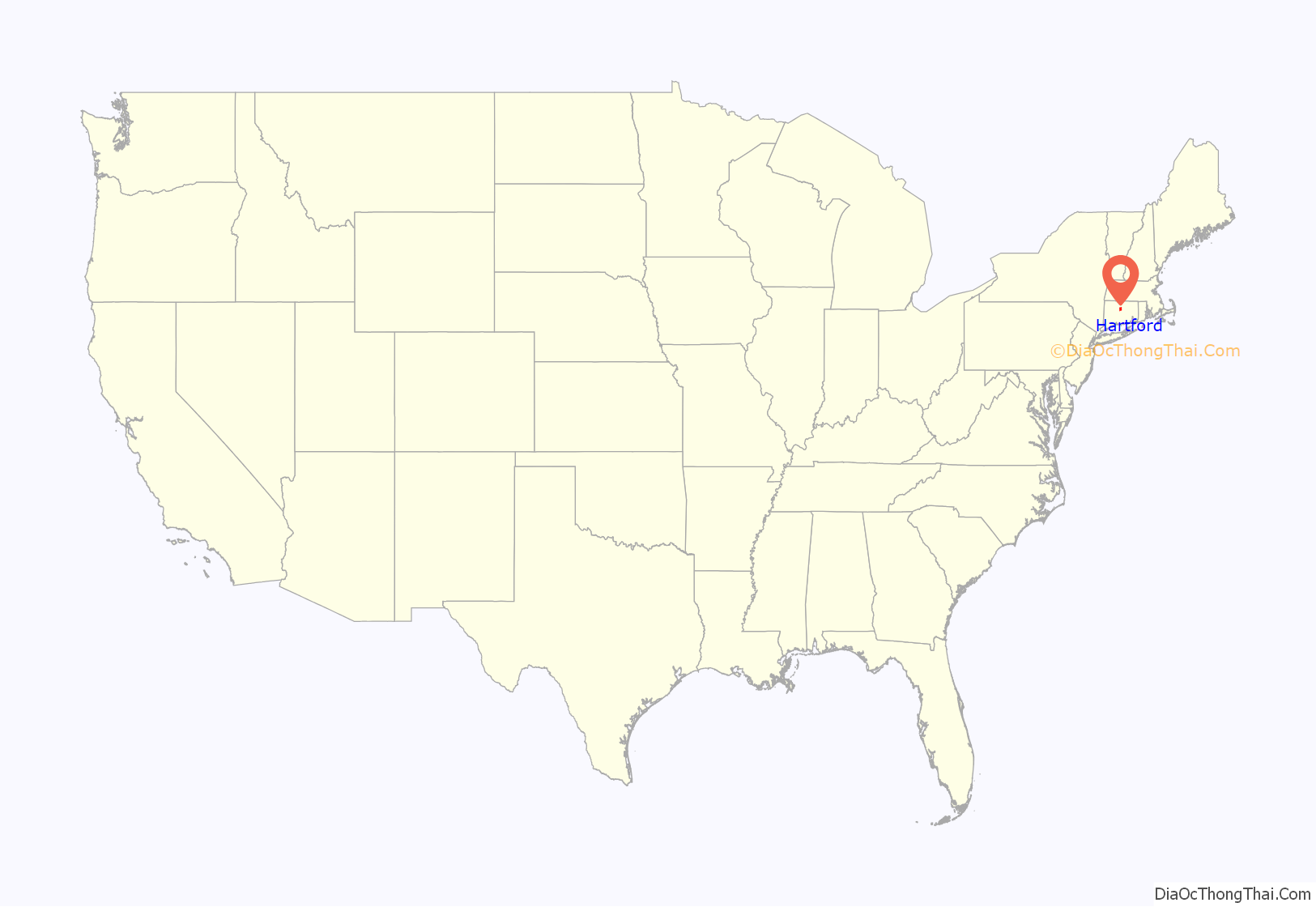
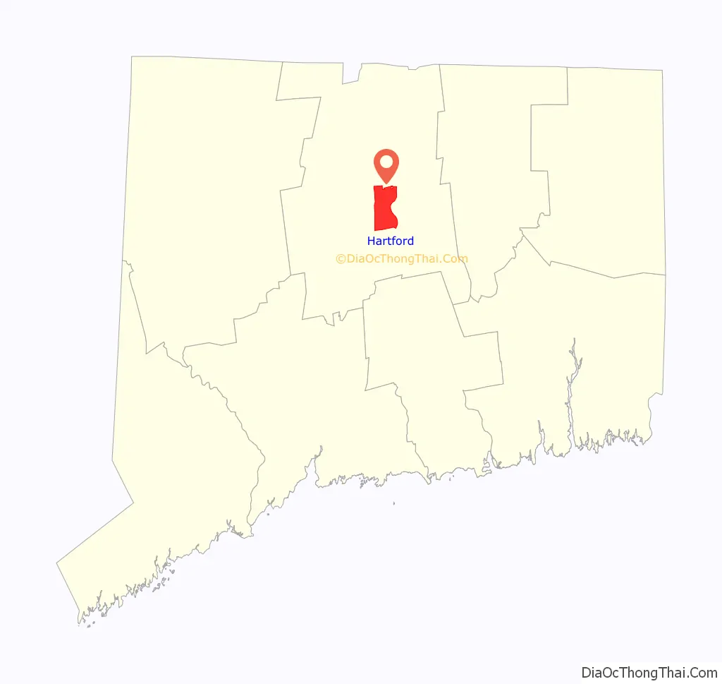
Hartford location map. Where is Hartford city?
History
Various tribes lived in or around Hartford, all Algonquian peoples. These included the Podunks, mostly east of the Connecticut River; the Poquonocks north and west of Hartford; the Massacoes in the Simsbury area; the Tunxis tribe in West Hartford and Farmington; the Wangunks to the south; and the Saukiog in Hartford itself.
Colonial Hartford
The first Europeans known to have explored the area were the Dutch under Adriaen Block, who sailed up the Connecticut in 1614. Dutch fur traders from New Amsterdam returned in 1623 with a mission to establish a trading post and fortify the area for the Dutch West India Company. The original site was located on the south bank of the Park River in the present-day Sheldon/Charter Oak neighborhood. This fort was called Fort Hoop or the “House of Hope.” In 1633, Jacob Van Curler formally bought the land around Fort Hoop from the Pequot chief for a small sum. It was home to perhaps a couple families and a few dozen soldiers. The fort was abandoned by 1654, but the area is known today as Dutch Point; the name of the Dutch fort “House of Hope” is reflected in the name of Huyshope Avenue. A significant reason for establishment of the Dutch trading post was to better control the flow of wampum, the de facto currency of New Netherlands and portions of New England, to and from valuable Native American fur traders.
The Dutch outpost and the tiny contingent of Dutch soldiers who were stationed there did little to check the English migration, and the Dutch soon realized that they were vastly outnumbered. The House of Hope remained an outpost, but it was steadily swallowed up by waves of English settlers. In 1650, Peter Stuyvesant met with English representatives to negotiate a permanent boundary between the Dutch and English colonies; the line that they agreed on was more than 50 miles (80 km) west of the original settlement.
The English began to arrive in 1636, settling upstream from Fort Hoop near the present-day Downtown and Sheldon/Charter Oak neighborhoods. Puritan pastors Thomas Hooker and Samuel Stone, along with Governor John Haynes, led 100 settlers with 130 head of cattle in a trek from Newtown in the Massachusetts Bay Colony (now Cambridge) and started their settlement just north of the Dutch fort. The settlement was originally called Newtown, but it was changed to Hartford in 1637 in honor of Stone’s hometown of Hertford, England. Hooker also created the nearby town of Windsor in 1633. The etymology of Hartford is the ford where harts cross, or “deer crossing.”
As the Puritan minister in Hartford, Thomas Hooker wielded a great deal of power; in 1638, he delivered a sermon that inspired the writing of the Fundamental Orders of Connecticut, which provided a framework for Connecticut’s separation for Massachusetts Bay Colony and the formation of a civil government. The Fundamental Orders of Connecticut were the legal basis for Connecticut Colony until the 1662 royal charter granted to Connecticut by Charles II.
The original settlement area contained the site of the Charter Oak, an old white oak tree in which colonists hid Connecticut’s Royal Charter of 1662 to protect it from confiscation by an English governor-general. The state adopted the oak tree as the emblem on the Connecticut state quarter. The Charter Oak Monument is located at the corner of Charter Oak Place, a historic street, and Charter Oak Avenue.
19th century
On December 15, 1814, delegates from the five New England states (Maine was still part of Massachusetts at that time) gathered at the Hartford Convention to discuss New England’s possible secession from the United States. During the early 19th century, the Hartford area was a center of abolitionist activity, and the most famous abolitionist family was the Beechers. The Reverend Lyman Beecher was an important Congregational minister known for his anti-slavery sermons. His daughter Harriet Beecher Stowe wrote Uncle Tom’s Cabin; her brother Henry Ward Beecher was a noted clergyman who vehemently opposed slavery and supported the temperance movement and women’s suffrage. The Stowes’ sister Isabella Beecher Hooker was a leading member of the women’s rights movement.
In 1860, Hartford was the site of the first “Wide Awakes”, abolitionist supporters of Abraham Lincoln. These supporters organized torch-light parades that were both political and social events, often including fireworks and music, in celebration of Lincoln’s visit to the city. This type of event caught on and eventually became a staple of mid-to-late 19th-century campaigning.
Hartford was a major manufacturing city from the 19th century until the mid-20th century. During the Industrial Revolution into the mid-20th century, the Connecticut River Valley cities produced many major precision manufacturing innovations. Among these was Hartford’s pioneer bicycle and automobile maker Pope. Many factories have been closed or relocated, or have reduced operations, as in nearly all former Northern manufacturing cities.
Around 1850, Hartford native Samuel Colt perfected the precision manufacturing process that enabled the mass production of thousands of his revolvers with interchangeable parts. A variety of industries adopted and adapted these techniques over the next several decades, and Hartford became the center of production for a wide array of products, including: Colt, Richard Gatling, and John Browning firearms; Weed sewing machines; Columbia bicycles; Pope automobiles; and leading typewriter manufacturers Royal Typewriter Company and Underwood Typewriter Company which together made Hartford the “Typewriter Capitol of the World” during the first half of the 20th century.
The Pratt & Whitney Company was founded in Hartford in 1860 by Francis A. Pratt and Amos Whitney. They built a substantial factory in which the company manufactured a wide range of machine tools, including tools for the makers of sewing machines, and gun-making machinery for use by the Union Army during the American Civil War. In 1925, the company expanded into aircraft engine design at its Hartford factory.
Just three years after Colt’s first factory opened, the Sharps Rifle Manufacturing Company set up shop in 1852 at a nearby site along the now-buried Park River, located in the present-day neighborhood of Frog Hollow. Their factory heralded the beginning of the area’s transformation from marshy farmland into a major industrial zone. The road leading from town to the factory was called Rifle Lane; the name was later changed to College Street and then Capitol Avenue. A century earlier, mills had located along the Park River because of the water power, but by the 1850s water power was approaching obsolescence. Sharps located there specifically to take advantage of the railroad line that had been constructed alongside the river in 1838.
The Sharps Rifle Company failed in 1870, and the Weed Sewing Machine Company took over its factory. The invention of a new type of sewing machine led to a new application of mass production after the principles of interchangeability were applied to clocks and guns. The Weed Company played a major role in making Hartford one of three machine tool centers in New England and even outranked the Colt Armory in nearby Coltsville in size. Weed eventually became the birthplace of both the bicycle and automobile industries in Hartford.
Industrialist Albert Pope was inspired by a British-made, high-wheeled bicycle (called a velocipede) that he saw at the 1876 Philadelphia Centennial Exposition, and he bought patent rights for bicycle production in the United States. He wanted to contract out his first order, however, so he approached George Fairfield of Weed Sewing Machine Company, who produced Pope’s first run of bicycles in 1878. Bicycles proved to be a huge commercial success, and production expanded in the Weed factory, with Weed making every part but the tires. Demand for bicycles overshadowed the failing sewing machine market by 1890, so Pope bought the Weed factory, took over as its president, and renamed it the Pope Manufacturing Company. The bicycle boom was short-lived, peaking near the turn of the century when more and more consumers craved individual automobile travel, and Pope’s company suffered financially from over-production amidst falling demand.
In an effort to save his business, Pope opened a motor carriage department and turned out electric carriages, beginning with the “Mark III” in 1897. His venture might have made Hartford the capital of the automobile industry were it not for the ascendancy of Henry Ford and a series of pitfalls and patent struggles that outlived Pope himself.
In 1876, Hartford Machine Screw was granted a charter “for the purpose of manufacturing screws, hardware and machinery of every variety.” The basis for its incorporation was the invention of the first single-spindle automatic screw machine. For its next four years, the new firm occupied one of Weed’s buildings, milling thousands of screws daily on over 50 machines. Its president was George Fairfield, who ran Weed, and its superintendent was Christopher Spencer, one of Connecticut’s most versatile inventors. Soon Hartford Machine Screw outgrew its quarters and built a new factory adjacent to Weed, where it remained until 1948.
20th century
On the week of April 12, 1909, the Connecticut River reached a record flood stage of 24.5 feet (7.5 meters) above the low-water mark, flooding the city of Hartford and doing great damage. On July 6, 1944, Hartford was the scene of one of the worst fire disasters in the history of the United States. Claiming the lives of 168 persons, mostly children and their mothers, and injuring several hundred more. It occurred at a matinee performance of the Ringling Brothers and Barnum and Bailey Circus on Barbour Street in the city’s north end and became known as the Hartford Circus Fire.
After World War II, many residents of Puerto Rico moved to Hartford. Starting in the late 1950s, the suburbs ringing Hartford began to grow and flourish and the capital city began a long decline. Insurance giant Connecticut General (now CIGNA) moved to a new, modern campus in the suburb of Bloomfield. Constitution Plaza had been hailed as a model of urban renewal, but it gradually became a concrete office park. Once-flourishing department stores shut down, such as Brown Thomson, Sage-Allen, and G. Fox & Co., as suburban malls grew in popularity, such as Westfarms and Buckland Hills.
In 1997, the city lost its professional hockey franchise, with the Hartford Whalers moving to Raleigh, North Carolina—despite an increase in season ticket sales and an offer from the state for a new arena. In 2005, a developer from Newton, Massachusetts tried unsuccessfully to bring an NHL team back to Hartford and house them in a new, publicly funded stadium.
Hartford experienced problems as the population shrank 11 percent during the 1990s. Only Flint, Michigan; Gary, Indiana; St. Louis, Missouri; and Baltimore, Maryland experienced larger population losses during the decade. However, the population has increased since the 2000 Census.
In 1987, Carrie Saxon Perry was elected mayor of Hartford, becoming the first female African-American mayor of a major American city. Riverfront Plaza was opened in 1999, connecting the riverfront and the downtown area for the first time since the 1960s.
21st century
A significant number of cultural events and performances take place every year at Mortensen Plaza (Riverfront Recapture Organization) by the banks of the Connecticut River. These events are held outdoors and include live music, festivals, dance, arts and crafts. Hartford also has a vibrant theater scene with major Broadway productions at the Bushnell Theater as well as performances at the Hartford Stage and TheaterWorks (City Arts).
In July 2017, Hartford considered filing Chapter 9 bankruptcy. After years of shrinking population base and high pension obligations, a $65 Million Dollar budget gap was projected for the year of 2018. The city had cut budget of public services and gotten union concessions however these measures did not balance the budget. A state bailout later that year kept the city from filing for bankruptcy.
Downtown Hartford is busy during the day with commuters, but tends to be quiet in the evenings and weekends. However, more residential and retail development in recent years has begun changing the pattern.
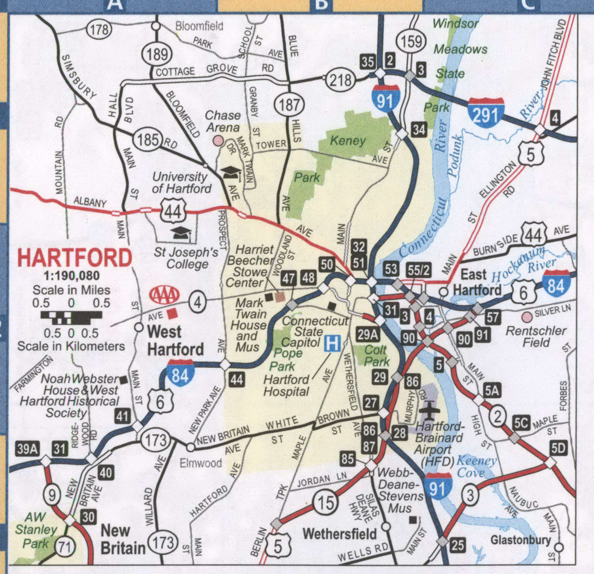
Hartford Road Map
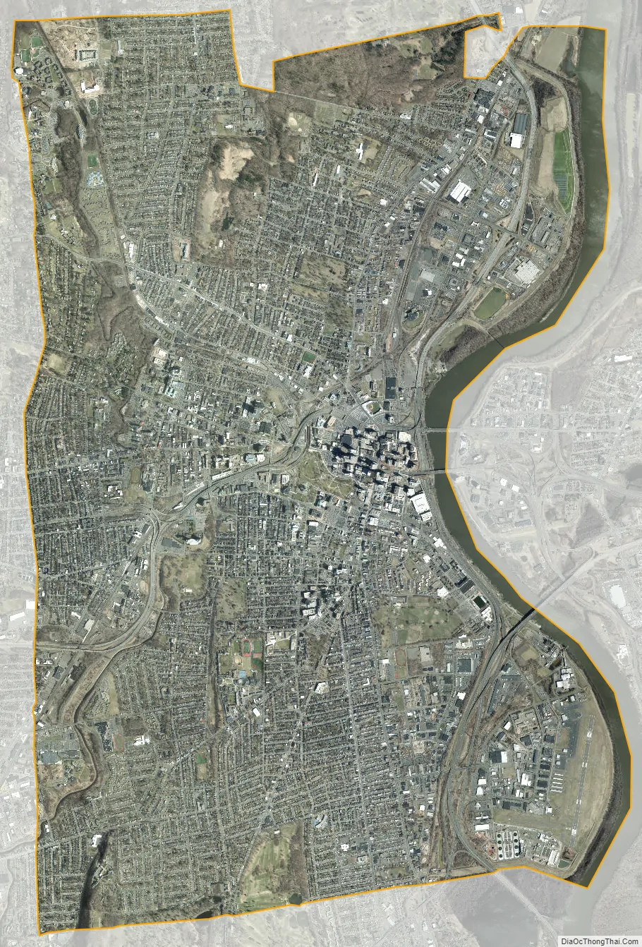
Hartford city Satellite Map
Geography
According to the United States Census Bureau, the city has a total area of 18.0 square miles (47 km), of which 17.3 square miles (45 km) is land and 0.7 square miles (1.8 km) (3.67%) is water.
The city of Hartford is bordered by the towns of West Hartford, Newington, Wethersfield, East Hartford, Bloomfield, South Windsor, Glastonbury, and Windsor. The Connecticut River forms the boundary between Hartford and East Hartford, and is located on the east side of the city.
The Park River originally divided Hartford into northern and southern sections and was a major part of Bushnell Park, but the river was nearly completely enclosed and buried by flood control projects in the 1940s. The former course of the river can still be seen in some of the roadways that were built in the river’s place, such as Jewell Street and the Conlin-Whitehead Highway.
Climate
The Köppen climate classification categorizes Hartford as falling within either the humid subtropical climate (Köppen Cfa) using the −3 °C (27 °F) isotherm, or the hot-summer humid continental climate (Köppen Dfa) under the 0 °C isotherm. Winters are cold, with periods of snow, while summers are hot and humid. Spring and fall are normally transition seasons, with weather ranging from warm to cool. The city of Hartford lies in USDA Hardiness zone 6a.
Seasonally, the period from May through October is warm to hot in Hartford, with the hottest months being June, July, and August. In the summer months there is often high humidity and occasional (but brief) thundershowers. The cool to cold months are from November through April, with the coldest months in December, January, and February having average highs of 35 to 38 °F (2 to 3 °C) and overnight lows of around 18 to 23 °F (−8 to −5 °C).
The average annual precipitation is approximately 47.05 inches (1,200 mm), which is distributed fairly evenly throughout the year. Hartford typically receives about 51.7 inches (131 cm) of snow in an average winter—about 40% more than coastal Connecticut cities like New Haven, Stamford, and New London. Seasonal snowfall has ranged from 115.2 inches (293 cm) during the winter of 1995–96 to 13.5 inches (34 cm) in 1999–2000. During the summer, temperatures reach or exceed 90 °F (32 °C) on an average of 17 days per year; in the winter, overnight temperatures can dip to a range of 5 to −5 °F (−15 to −21 °C) on at least one night a year. Tropical storms and hurricanes have also struck Hartford, although the occurrence of such systems is rare and is usually confined to the remnants of such storms. Hartford saw extensive damage from the 1938 New England Hurricane, as well as with Hurricane Irene in 2011. The highest officially recorded temperature is 103 °F (39 °C) on July 22, 2011, and the lowest is −26 °F (−32 °C) on January 22, 1961; the record cold daily maximum is −2 °F (−19 °C) on December 2, 1917, while, conversely, the record warm daily minimum is 80 °F (27 °C) on July 31, 1917.
Neighborhoods
The central business district, as well as the State Capitol, Old State House and a number of museums and shops are located Downtown. Parkville, home to Real Art Ways, is named for the confluence of the north and the south branches of the Park River. Frog Hollow, in close proximity to Downtown, is home to Pope Park and Trinity College, which is one of the nation’s oldest institutions of higher learning. Asylum Hill, a mixed residential and commercial area, houses the headquarters of several insurance companies as well as the historic homes of Mark Twain and Harriet Beecher Stowe. The West End, home to the Governor’s residence, Elizabeth Park, and the University of Connecticut School of Law, abuts the Hartford Golf Club. Sheldon Charter Oak is renowned as the location of the Charter Oak and its successor monument as well as the former Colt headquarters including Samuel Colt’s family estate, Armsmear. The North East neighborhood is home to Keney Park and a number of the city’s oldest and most ornate homes. The South End features “Little Italy” and was the home of Hartford’s sizeable Italian community. South Green hosts Hartford Hospital. The South Meadows is the site of Hartford–Brainard Airport and Hartford’s industrial community. The North Meadows has retail strips, car dealerships, and Comcast Theatre. Blue Hills is home of the University of Hartford and also houses the largest per capita of residents claiming Jamaican-American heritage in the United States. Other neighborhoods in Hartford include Barry Square, Behind the Rocks, Clay Arsenal, South West, and Upper Albany, which is dotted by many Caribbean restaurants and specialty stores.
See also
Map of Connecticut State and its subdivision: Map of other states:- Alabama
- Alaska
- Arizona
- Arkansas
- California
- Colorado
- Connecticut
- Delaware
- District of Columbia
- Florida
- Georgia
- Hawaii
- Idaho
- Illinois
- Indiana
- Iowa
- Kansas
- Kentucky
- Louisiana
- Maine
- Maryland
- Massachusetts
- Michigan
- Minnesota
- Mississippi
- Missouri
- Montana
- Nebraska
- Nevada
- New Hampshire
- New Jersey
- New Mexico
- New York
- North Carolina
- North Dakota
- Ohio
- Oklahoma
- Oregon
- Pennsylvania
- Rhode Island
- South Carolina
- South Dakota
- Tennessee
- Texas
- Utah
- Vermont
- Virginia
- Washington
- West Virginia
- Wisconsin
- Wyoming


