Cambridge (/ˈkeɪmbrɪdʒ/ KAYM-brij) is a city in Middlesex County, Massachusetts, in the United States. It is a major suburb in the Greater Boston metropolitan area, located directly across the Charles River from Boston. The city’s population as of the 2020 U.S. census was 118,403, making it the largest city in the county, the fourth most populous city in the state, behind Boston, Worcester, and Springfield, and ninth most populous city in New England. It was named in honor of the University of Cambridge in England, which was an important center of the Puritan theology that was embraced by the town’s founders.
Cambridge is known globally as home to two of the world’s most prestigious universities. Harvard University, an Ivy League university founded in Cambridge in 1636, is the oldest institution of higher learning in the nation and has routinely been ranked as one of the best universities in the world. The Massachusetts Institute of Technology (MIT), founded in 1861, is also located in Cambridge and has been similarly ranked highly among the world’s best universities. Lesley University and Hult International Business School also are based in Cambridge. Radcliffe College, an elite women’s liberal arts college, also was based in Cambridge from its 1879 founding until its assimiliation into Harvard in 1999.
Kendall Square, near MIT in the eastern part of Cambridge, has been called “the most innovative square mile on the planet” due to the high concentration of startup companies that have emerged there since 2010.
| Name: | Cambridge city |
|---|---|
| LSAD Code: | 25 |
| LSAD Description: | city (suffix) |
| State: | Massachusetts |
| County: | Middlesex County |
| Incorporated: | 1636 |
| Elevation: | 40 ft (12 m) |
| Total Area: | 7.10 sq mi (18.40 km²) |
| Land Area: | 6.40 sq mi (16.57 km²) |
| Water Area: | 0.71 sq mi (1.83 km²) |
| Total Population: | 118,403 |
| Population Density: | 18,512.04/sq mi (7,147.01/km²) |
| ZIP code: | 02138-02142 |
| Area code: | 617 / 857 |
| FIPS code: | 2511000 |
| GNISfeature ID: | 0617365 |
| Website: | cambridgema.gov |
Online Interactive Map
Click on ![]() to view map in "full screen" mode.
to view map in "full screen" mode.
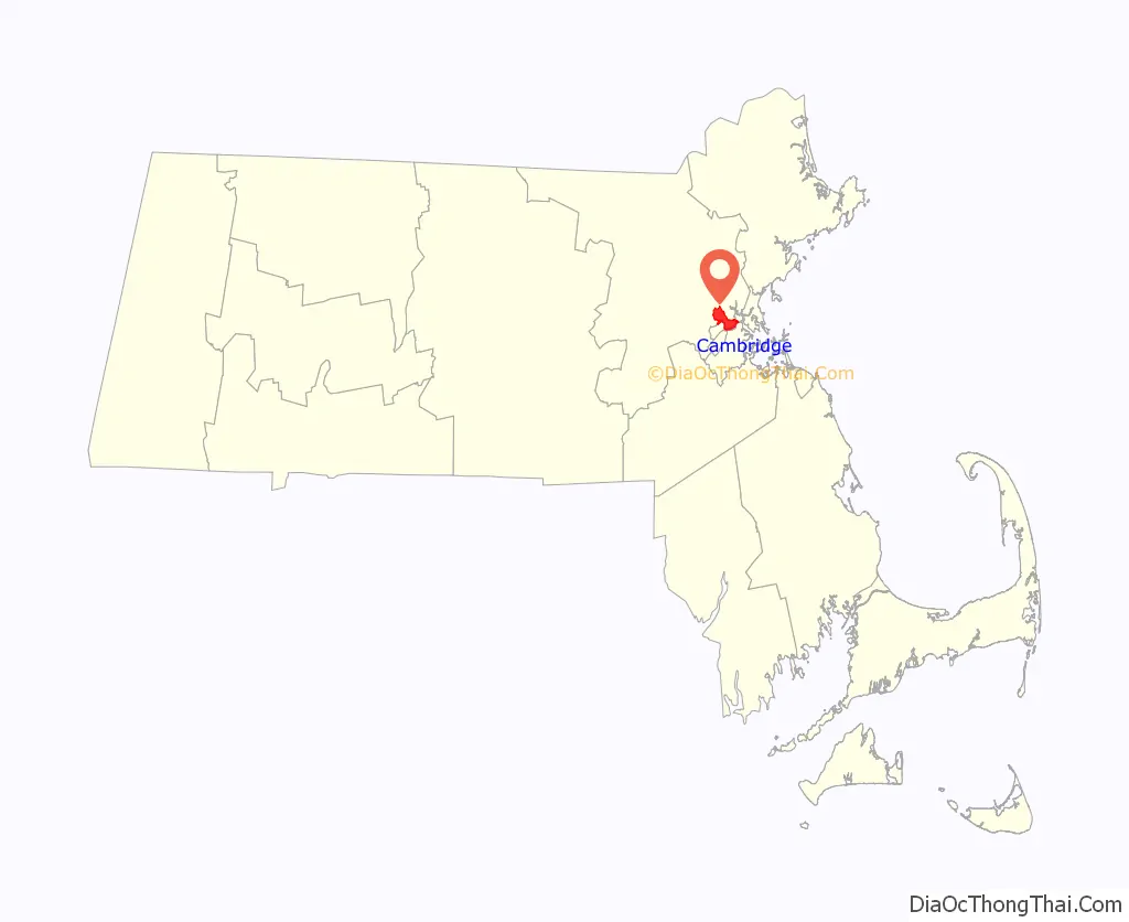
Cambridge location map. Where is Cambridge city?

History
Pre-colonization
Native Americans inhabited the area that would become Cambridge for thousands of years prior to European colonization of the Americas. At the time of European contact and exploration, the area was inhabited by Naumkeag or Pawtucket to the north and Massachusett to the south, and may have been inhabited by other groups such as the Totant not well described in later European narratives. The contact period introduced a number of European infectious diseases which would decimate native populations in virgin soil epidemics, leaving the area uncontested upon the arrival of large groups of English settlers in 1630.
17th century and colonialism
In December 1630, the site of present-day Cambridge was chosen for settlement because it was safely upriver from Boston Harbor, making it easily defensible from attacks by enemy ships. The city was founded by Thomas Dudley, his daughter Anne Bradstreet, and his son-in-law Simon Bradstreet. The first houses were built in the spring of 1631. The settlement was initially referred to as “the newe towne”. Official Massachusetts records show the name rendered as Newe Towne by 1632, and as Newtowne by 1638.
Located at the first convenient Charles River crossing west of Boston, Newtowne was one of several towns, including Boston, Dorchester, Watertown, and Weymouth, founded by the 700 original Puritan colonists of the Massachusetts Bay Colony under Governor John Winthrop. Its first preacher was Thomas Hooker, who led many of its original inhabitants west in 1636 to found Hartford and the Connecticut Colony; before leaving, they sold their plots to more recent immigrants from England. The original village site is now within Harvard Square. The marketplace where farmers sold crops from surrounding towns at the edge of a salt marsh (since filled) remains within a small park at the corner of John F. Kennedy and Winthrop Streets.
In 1636, Newe College, later renamed Harvard College after benefactor John Harvard, was founded as North America’s first institution of higher learning. Its initial purpose was training ministers. According to Cotton Mather, Newtowne was chosen for the site of the college by the Great and General Court, then the legislature of Massachusetts Bay Colony, primarily for its proximity to the popular and highly respected Puritan preacher Thomas Shepard. In May 1638, the settlement’s name was changed to Cambridge in honor of the University of Cambridge in Cambridge, England.
In 1639, the Massachusetts General Court purchased the land that became present-day Cambridge from the Naumkeag Squaw Sachem of Mistick.
The town comprised a much larger area than the present city, with various outlying parts becoming independent towns over the years: Cambridge Village (later Newtown and now Newton) in 1688, Cambridge Farms (now Lexington) in 1712 or 1713, and Little or South Cambridge (now Brighton) and Menotomy or West Cambridge (now Arlington) in 1807. In the late 19th century, various schemes for annexing Cambridge to Boston were pursued and rejected.
Newtowne’s ministers, Hooker and Shepard, the college’s first president, the college’s major benefactor, and the first schoolmaster Nathaniel Eaton were all Cambridge alumni, as was the colony’s governor John Winthrop. In 1629, Winthrop had led the signing of the founding document of the city of Boston, which was known as the Cambridge Agreement, after the university. In 1650, Governor Thomas Dudley signed the charter creating the corporation that still governs Harvard College.
Cambridge grew slowly as an agricultural village eight miles (13 km) by road from Boston, the colony’s capital. By the American Revolution, most residents lived near the Common and Harvard College, with most of the town comprising farms and estates. Most inhabitants were descendants of the original Puritan colonists, but there was also a small elite of Anglican “worthies” who were not involved in village life, made their livings from estates, investments, and trade, and lived in mansions along “the Road to Watertown”, present-day Brattle Street, which is still known as Tory Row.
18th century and Revolutionary War
Coming south from Virginia, George Washington took command of the force of Patriot soldiers camped on Cambridge Common on July 3, 1775, which is now considered the birthplace of the Continental Army.
On January 24, 1776, Henry Knox arrived with an artillery train captured from Fort Ticonderoga, which allowed Washington to force the British Army to evacuate Boston. Most of the Loyalist estates in Cambridge were confiscated after the Revolutionary War.
19th century and industrialization
Between 1790 and 1840, Cambridge grew rapidly with the construction of West Boston Bridge in 1792 connecting Cambridge directly to Boston, making it no longer necessary to travel eight miles (13 km) through the Boston Neck, Roxbury, and Brookline to cross the Charles River. A second bridge, the Canal Bridge, opened in 1809 alongside the new Middlesex Canal. The new bridges and roads made what were formerly estates and marshland into prime industrial and residential districts.
In the mid-19th century, Cambridge was the center of a literary revolution. It was home to some of the famous Fireside poets, named because their poems would often be read aloud by families in front of their evening fires. The Fireside poets, including Henry Wadsworth Longfellow, James Russell Lowell, and Oliver Wendell Holmes, were highly popular and influential in this era.
Soon after, turnpikes were built: the Cambridge and Concord Turnpike (today’s Broadway and Concord Ave.), the Middlesex Turnpike (Hampshire St. and Massachusetts Ave. northwest of Porter Square), and what are today’s Cambridge, Main, and Harvard Streets connected various areas of Cambridge to the bridges. In addition, the town was connected to the Boston & Maine Railroad, leading to the development of Porter Square as well as the creation of neighboring Somerville from the formerly rural parts of Charlestown.
Cambridge was incorporated as a city in 1846. The city’s commercial center began to shift from Harvard Square to Central Square, which became the city’s downtown around that time.
Between 1850 and 1900, Cambridge took on much of its present character, featuring streetcar suburban development along the turnpikes and working class and industrial neighborhoods focused on East Cambridge, comfortable middle-class housing on the old Cambridgeport, and Mid-Cambridge estates and upper-class enclaves near Harvard University and on the minor hills. The arrival of the railroad in North Cambridge and Northwest Cambridge led to three major changes: the development of massive brickyards and brickworks between Massachusetts Avenue, Concord Avenue, and Alewife Brook; the ice-cutting industry launched by Frederic Tudor on Fresh Pond; and the carving up of the last estates into residential subdivisions to house the thousands of immigrants who arrived to work in the new industries.
For much of the 19th and early 20th centuries, the city’s largest employer was the New England Glass Company, founded in 1818. By the middle of the 19th century, it was the world’s largest and most modern glassworks. In 1888, Edward Drummond Libbey moved all production to Toledo, Ohio, where it continues today under the name Owens-Illinois. The company’s flint glassware with heavy lead content is prized by antique glass collectors, and the Toledo Museum of Art has a large collection. The Museum of Fine Arts in Boston and the Sandwich Glass Museum on Cape Cod also house several pieces.
In 1895, Edwin Ginn, founder of Ginn and Company, built the Athenaeum Press Building for his publishing textbook empire.
20th century
By 1920, Cambridge was one of New England’s main industrial cities, with nearly 120,000 residents. Among the largest businesses in Cambridge during the period of industrialization was Carter’s Ink Company, whose neon sign long adorned the Charles River and which was for many years the world’s largest ink manufacturer. Next door was the Athenaeum Press. Confectionery and snack manufacturers in the Cambridgeport-Area 4-Kendall corridor included Kennedy Biscuit Factory, later part of Nabisco and originator of the Fig Newton, Necco, Squirrel Brands, George Close Company (1861–1930s), Page & Shaw, Daggett Chocolate (1892–1960s, recipes bought by Necco), Fox Cross Company (1920–1980, originator of the Charleston Chew, and now part of Tootsie Roll Industries), Kendall Confectionery Company, and James O. Welch (1927–1963, originator of Junior Mints, Sugar Daddies, Sugar Mamas, and Sugar Babies, now part of Tootsie Roll Industries). Main Street was nicknamed “Confectioner’s Row”.
Only the Cambridge Brands subsidiary of Tootsie Roll Industries remains in town, still manufacturing Junior Mints in the old Welch factory on Main Street. The Blake and Knowles Steam Pump Company (1886), the Kendall Boiler and Tank Company (1880, now in Chelmsford, Massachusetts), and the New England Glass Company (1818–1878) were among the industrial manufacturers in what are now Kendall Square and East Cambridge.
In 1935, the Cambridge Housing Authority and the Public Works Administration demolished an integrated low-income tenement neighborhood with African Americans and European immigrants. In its place, it built the whites-only “Newtowne Court” public housing development and the adjoining, blacks-only “Washington Elms” project in 1940; the city required segregation in its other public housing projects as well.
As industry in New England began to decline during the Great Depression and after World War II, Cambridge lost much of its industrial base. It also began to become an intellectual, rather than an industrial, center. Harvard University, which had always been important as both a landowner and an institution, began to play a more dominant role in the city’s life and culture. When Radcliffe College was established in 1879, the town became a mecca for some of the nation’s most academically talented female students. MIT’s move from Boston to Cambridge in 1916 reinforced Cambridge’s status as an intellectual center of the United States.
After the 1950s, the city’s population began to decline slowly as families tended to be replaced by single people and young couples. In Cambridge Highlands, the technology company Bolt, Beranek, & Newman produced the first network router in 1969 and hosted the invention of computer-to-computer email in 1971. The 1980s brought a wave of high technology startups. Those selling advanced minicomputers were overtaken by the microcomputer. Cambridge-based VisiCorp made the first spreadsheet software for personal computers, Visicalc, and helped propel the Apple II to major consumer success. It was overtaken and purchased by Cambridge-based Lotus Development, maker of Lotus 1-2-3 (which was, in turn, replaced in by Microsoft Excel).
The city continues to be home to many startups. Kendall Square was a major software hub through the dot-com boom and today hosts offices of such technology companies as Google, Microsoft, and Amazon. The Square also now houses the headquarters of Akamai.
In 1976, Harvard’s plans to start experiments with recombinant DNA led to a three-month moratorium and a citizen review panel. In the end, Cambridge decided to allow such experiments but passed safety regulations in 1977. This led to regulatory certainty and acceptance when Biogen opened a lab in 1982, in contrast to the hostility that caused the Genetic Institute, a Harvard spinoff, to abandon Somerville and Boston for Cambridge. The biotech and pharmaceutical industries have since thrived in Cambridge, which now includes headquarters for Biogen and Genzyme; laboratories for Novartis, Teva, Takeda, Alnylam, Ironwood, Catabasis, Moderna Therapeutics, Editas Medicine; support companies such as Cytel; and many smaller companies.
By the end of the 20th century, Cambridge had one of the most costly housing markets in the Northeastern United States. While considerable class, race, and age diversity existed, it became more challenging for those who grew up in the city to afford to remain. The end of rent control in 1994 prompted many Cambridge renters to move to more affordable housing in Somerville and other Massachusetts cities and towns.
21st century
Cambridge’s mix of amenities and proximity to Boston kept housing prices relatively stable despite the bursting of the United States housing bubble in 2008 and 2009. Cambridge has been a sanctuary city since 1985 and reaffirmed its status as such in 2006.
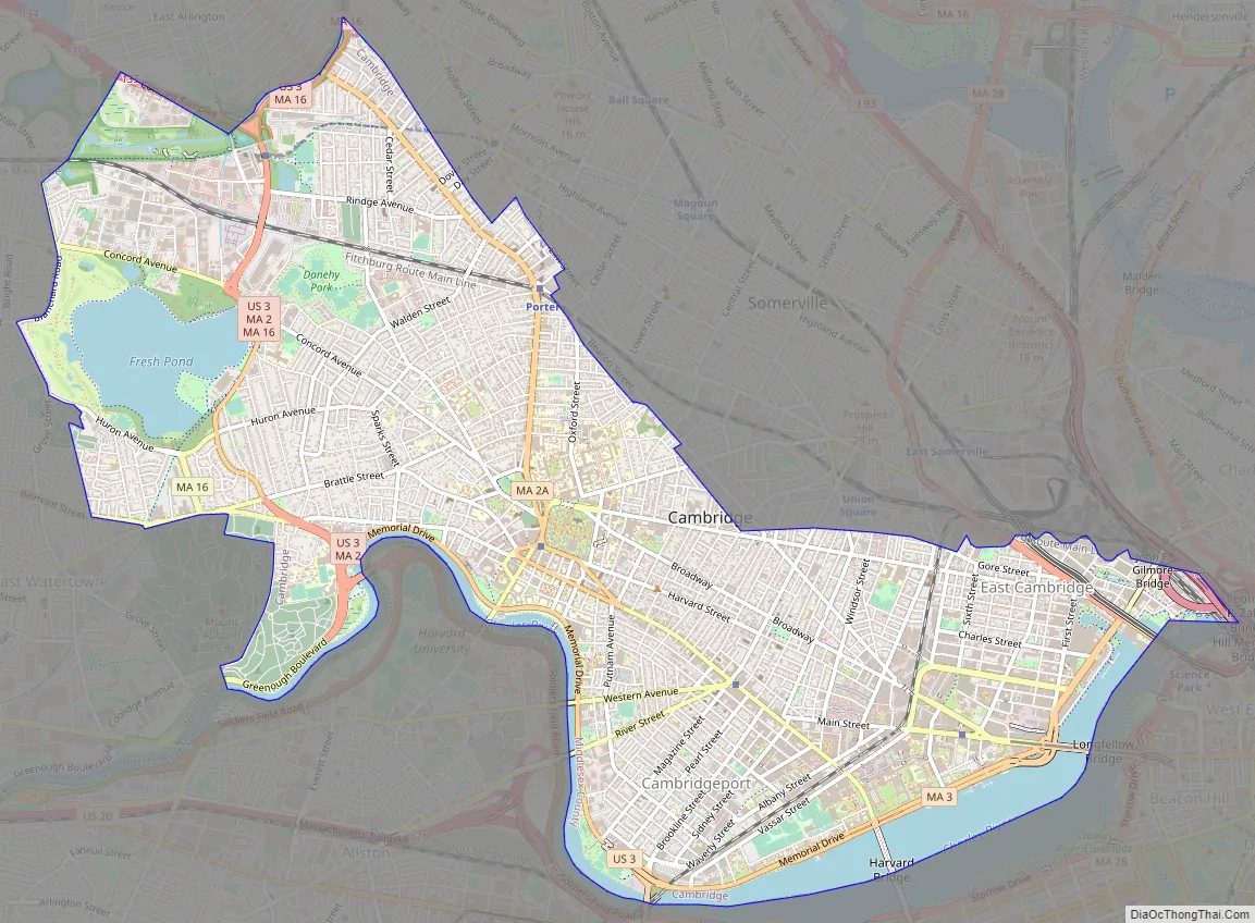
Cambridge Road Map
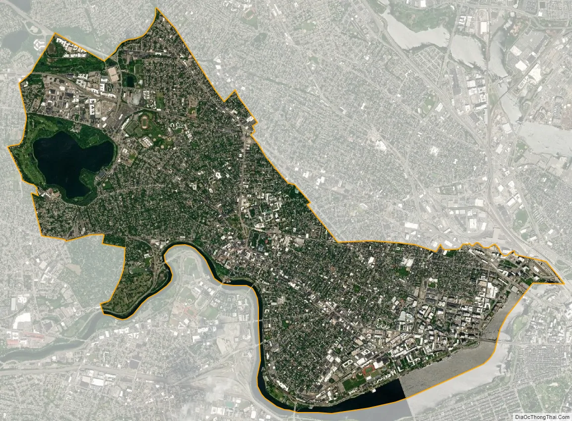
Cambridge city Satellite Map
Geography
According to the U.S. Census Bureau, Cambridge has a total area of 7.1 square miles (18 km), of which 6.4 square miles (17 km) is land and 0.7 square miles (1.8 km) (9.82%) is water.
Adjacent municipalities
Cambridge is located in eastern Massachusetts, bordered by:
- the city of Boston to the south and east (across the Charles River)
- the city of Somerville to the north
- the town of Arlington to the northwest
- the town of Belmont and
- the city of Watertown to the west
The border between Cambridge and the neighboring city of Somerville passes through densely populated neighborhoods, which are connected by the MBTA Red Line. Some of the main squares, Inman, Porter, and to a lesser extent, Harvard and Lechmere, are very close to the city line, as are Somerville’s Union and Davis Squares.
Through the City of Cambridge’s exclusive municipal water system, the city further controls two exclave areas, one being Payson Park Reservoir and Gatehouse, a 2009 listed American Water Landmark located roughly one mile west of Fresh Pond and surrounded by the town of Belmont. The second area is the larger Hobbs Brook and Stony Brook watersheds, which share borders with neighboring towns and cities including Lexington, Lincoln, Waltham and Weston.
Neighborhoods
Cambridge has been called the “City of Squares”, as most of its commercial districts are major street intersections known as squares. Each square acts as a neighborhood center. These include:
- Kendall Square, formed by the junction of Broadway, Main Street, and Third Street, has been called “the most innovative square mile on the planet”, owing to its high concentration of entrepreneurial start-ups and quality of innovation which have emerged in the vicinity of the square since 2010. Technology Square is an office and laboratory building cluster in this neighborhood. Just over the Longfellow Bridge from Boston, at the eastern end of the MIT campus, it is served by the Kendall/MIT station on the MBTA Red Line subway. Most of Cambridge’s large office towers are located in the Square. A biotech industry has developed in this area. The Cambridge Innovation Center, a large co-working space, is in Kendall Square at 1 Broadway. The Cambridge Center office complex is in Kendall Square, and not at the actual center of Cambridge. The “One Kendall Square” complex is nearby, but not actually in Kendall Square.
- Central Square, formed by the junction of Massachusetts Avenue, Prospect Street, and Western Avenue. Containing a variety of ethnic restaurants, it was economically depressed as recently as the late 1990s; it underwent gentrification in recent years (in conjunction with the development of the nearby University Park at MIT), and continues to grow more costly. It is served by the Central Station stop on the MBTA Red Line subway. Lafayette Square, formed by the junction of Massachusetts Avenue, Columbia Street, Sidney Street, and Main Street, is considered part of the Central Square area. Cambridgeport is south of Central Square along Magazine Street and Brookline Street.
- Harvard Square, formed by the junction of Massachusetts Avenue, Brattle Street, and JFK Street. This is the primary site of Harvard University and a major Cambridge shopping area. It is served by a Red Line station. Harvard Square was originally the Red Line’s northwestern terminus and a major transfer point to streetcars that also operated in a short tunnel—which is still a major bus terminal, although the area under the Square was reconfigured dramatically in the 1980s when the Red Line was extended. The Harvard Square area includes Brattle Square and Eliot Square. A short distance away from the square lies the Cambridge Common, while the neighborhood north of Harvard and east of Massachusetts Avenue is known as Agassiz, after the famed scientist Louis Agassiz.
- Porter Square, about a mile north on Massachusetts Avenue from Harvard Square, at the junction of Massachusetts and Somerville Avenues. It includes part of the city of Somerville and is served by the Porter Square Station, a complex housing a Red Line stop and a Fitchburg Line commuter rail stop. Lesley University’s University Hall and Porter campus are in Porter Square.
- Inman Square, at the junction of Cambridge and Hampshire streets in mid-Cambridge. It is home to restaurants, bars, music venues, and boutiques. Victorian streetlights, benches, and bus stops were added to the streets in the 2000s, and a new city park was installed.
- Lechmere Square, at the junction of Cambridge and First streets, adjacent to the CambridgeSide Galleria shopping mall. It is served by Lechmere station on the MBTA Green Line.
- Areas of Cambridge
Central Square
Harvard Square
Inman Square
Cambridge’s residential neighborhoods border but are not defined by the squares.
- East Cambridge (Area 1) is bordered on the north by Somerville, on the east by the Charles River, on the south by Broadway and Main Street, and on the west by the Grand Junction Railroad tracks. It includes the NorthPoint development.
- MIT Campus (Area 2) is bordered on the north by Broadway, on the south and east by the Charles River, and on the west by the Grand Junction Railroad tracks.
- Wellington-Harrington (Area 3) is bordered on the north by Somerville, on the south and west by Hampshire Street, and on the east by the Grand Junction Railroad tracks. Referred to as “Mid-Block”.
- The Port, formerly known as Area 4, is bordered on the north by Hampshire Street, on the south by Massachusetts Avenue, on the west by Prospect Street, and on the east by the Grand Junction Railroad tracks. Residents of Area 4 often simply call their neighborhood “The Port” and the area of Cambridgeport and Riverside “The Coast”. In October 2015, the Cambridge City Council officially renamed Area 4 “The Port”, formalizing the longtime nickname, largely on the initiative of neighborhood native and then-Vice Mayor Dennis Benzan. The port is usually the busier part of the city.
- Cambridgeport (Area 5) is bordered on the north by Massachusetts Avenue, on the south by the Charles River, on the west by River Street, and on the east by the Grand Junction Railroad tracks.
- Mid-Cambridge (Area 6) is bordered on the north by Kirkland and Hampshire Streets and Somerville, on the south by Massachusetts Avenue, on the west by Peabody Street, and on the east by Prospect Street.
- Riverside (Area 7), an area sometimes called “The Coast”, is bordered on the north by Massachusetts Avenue, on the south by the Charles River, on the west by JFK Street, and on the east by River Street.
- Baldwin (Area 8) is bordered on the north by Somerville, on the south and east by Kirkland Street, and on the west by Massachusetts Avenue.
- Neighborhood Nine or Radcliffe (formerly called Peabody, until the recent relocation of a neighborhood school by that name) is bordered on the north by railroad tracks, on the south by Concord Avenue, on the west by railroad tracks, and on the east by Massachusetts Avenue.
- Brattle area/West Cambridge (Area 10) is bordered on the north by Concord Avenue and Garden Street, on the south by the Charles River and Watertown, on the west by Fresh Pond and the Collins Branch Library, and on the east by JFK Street. It includes the sub-neighborhoods of Brattle Street (formerly known as Tory Row) and Huron Village.
- North Cambridge (Area 11) is bordered on the north by Arlington and Somerville, on the south by railroad tracks, on the west by Belmont, and on the east by Somerville.
- Cambridge Highlands (Area 12) is bordered on the north and east by railroad tracks, on the south by Fresh Pond, and on the west by Belmont.
- Strawberry Hill (Area 13) is bordered on the north by Fresh Pond, on the south by Watertown, on the west by Belmont, and on the east by the Watertown-Cambridge Greenway (formerly railroad tracks).
Climate
In the Köppen-Geiger classification, Cambridge has a hot-summer humid continental climate (Dfa) with hot summers and cold winters, that can appear in the southern end of New England’s interior. Abundant rain falls on the city (and in the winter often as snow); it has no dry season. The average January temperature is 26.6 °F (–3 °C), making Cambridge part of Group D, independent of the isotherm. There are four well-defined seasons.
See also
Map of Massachusetts State and its subdivision: Map of other states:- Alabama
- Alaska
- Arizona
- Arkansas
- California
- Colorado
- Connecticut
- Delaware
- District of Columbia
- Florida
- Georgia
- Hawaii
- Idaho
- Illinois
- Indiana
- Iowa
- Kansas
- Kentucky
- Louisiana
- Maine
- Maryland
- Massachusetts
- Michigan
- Minnesota
- Mississippi
- Missouri
- Montana
- Nebraska
- Nevada
- New Hampshire
- New Jersey
- New Mexico
- New York
- North Carolina
- North Dakota
- Ohio
- Oklahoma
- Oregon
- Pennsylvania
- Rhode Island
- South Carolina
- South Dakota
- Tennessee
- Texas
- Utah
- Vermont
- Virginia
- Washington
- West Virginia
- Wisconsin
- Wyoming


