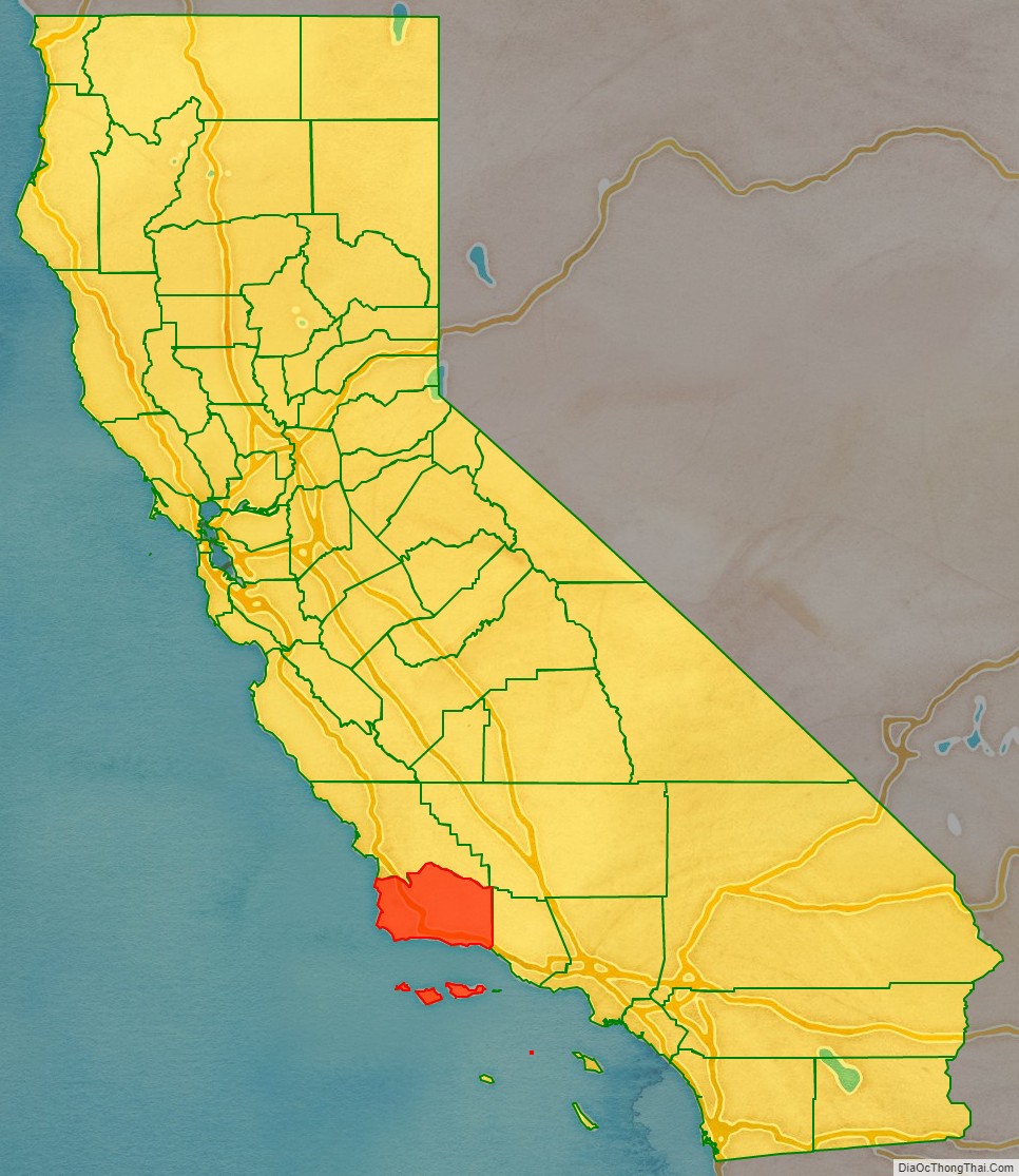
Santa Barbara County, officially the County of Santa Barbara (Spanish: Condado de Santa Bárbara), is located in Southern California. As of the 2020 census, the population was 448,229. The county seat is Santa Barbara, and the largest city is Santa Maria.
Santa Barbara County comprises the Santa Maria-Santa Barbara, CA Metropolitan Statistical Area. Most of the county is part of the California Central Coast. Mainstays of the county’s economy include engineering, resource extraction (particularly petroleum extraction and diatomaceous earth mining), winemaking, agriculture, and education. The software development and tourism industries are important employers in the southern part of the county.
Southern Santa Barbara County is sometimes considered the northern cultural boundary of Southern California.
| Name: | Santa Barbara County |
|---|---|
| FIPS code: | 06-083 |
| State: | California |
| Founded: | 1850 |
| Named for: | The city of Santa Barbara, which was named for Saint Barbara |
| Seat: | Santa Barbara |
| Largest city: | Santa Maria (population) Santa Barbara (area) |
| Total Area: | 3,789 sq mi (9,810 km²) |
| Land Area: | 2,735 sq mi (7,080 km²) |
| Total Population: | 448,229 |
| Population Density: | 163/sq mi (63/km²) |
| Time zone: | UTC−8 (Pacific Time Zone) |
| Summer Time Zone (DST): | UTC−7 (Pacific Daylight Time) |
| Website: | CountyofSB.org |
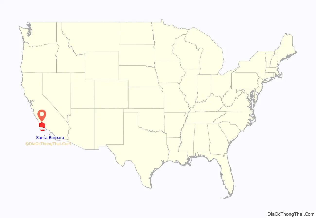
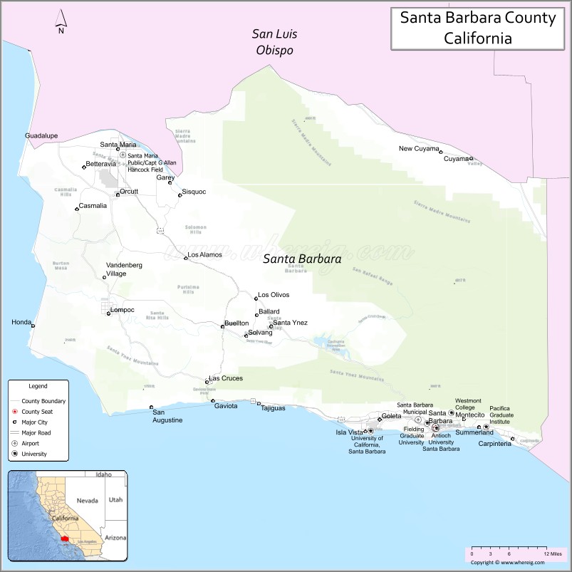
Santa Barbara County location map. Where is Santa Barbara County?
History
The Santa Barbara County area, including the Northern Channel Islands, was first settled by Native Americans at least 13,000 years ago. Evidence for a Paleoindian presence has been found in the form of a fluted Clovis-like point found in the 1980s along the western Santa Barbara Coast, as well as the remains of Arlington Springs Man found on Santa Rosa Island in the 1960s. For thousands of years, the area was home to the Chumash tribe of Native Americans, complex hunter-gatherers who lived along the coast and in interior valleys leaving rock art in many locations, including Painted Cave.
Europeans first contacted the Chumash in AD 1542, when three Spanish ships under the command of Juan Rodríguez Cabrillo explored the area. The Santa Barbara Channel received its name from Spanish explorer Sebastián Vizcaíno when he sailed along the California coast in 1602; his ships entered the channel on December 4, the day of the feast of Santa Barbara. Spanish ships associated with the Manila Galleon trade probably made emergency stops along the coast during the next 167 years, but no permanent settlements were established.
The first land expedition to explore California, led by Gaspar de Portolà explored the coastal area in 1769, on its way to Monterey Bay. The party traveled the same route on the return to San Diego in January 1770. That same year, a second expedition to Monterey again passed through the area. The DeAnza expeditions of 1774-76 followed Portola’s trail.
The Presidio of Santa Barbara was established in 1782 (4th of 5 in California), followed by Mission Santa Barbara in 1786 – both in what is now the city of Santa Barbara. The presidio and mission kept Vizcaino’s denomination, as did the later city and county – a common practice which has preserved the names of many of the 21 California Missions. Other missions in Santa Barbara County are located in Santa Ynez and Lompoc.
European contacts had devastating effects on the Chumash people, including a series of disease epidemics that drastically reduced Chumash population. The Chumash survived, however, and thousands of Chumash descendants still live in the Santa Barbara area or surrounding counties. A tribal homeland was established in 1901, the Santa Ynez Reservation.
Following the Mexican secularization of the missions in the 1830s, the mission pasture lands were mostly broken up into large ranchos and granted mainly to prominent local citizens who already lived in the area. 604 of these land grants were later confirmed by the state of California, with 36 in Santa Barbara County.
Santa Barbara County was one of the 27 original counties of California, formed in 1850 at the time of statehood. The county’s territory was later divided to create Ventura County in 1873.
Santa Barbara County Road Map
Geography
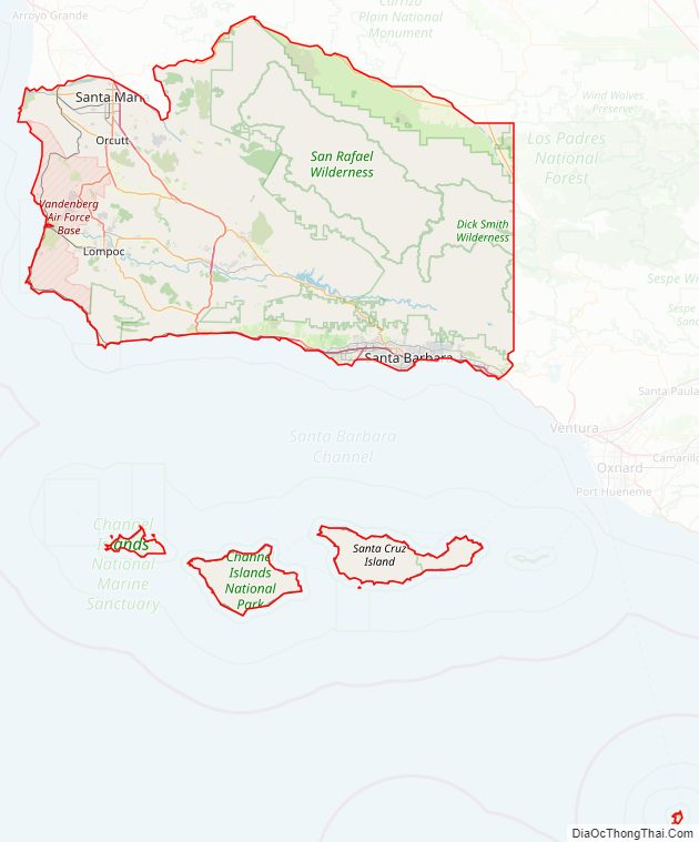
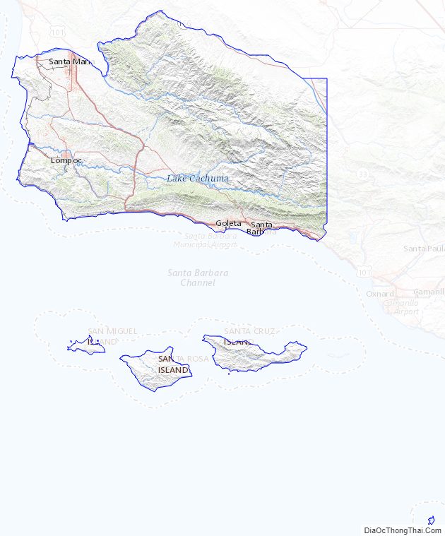
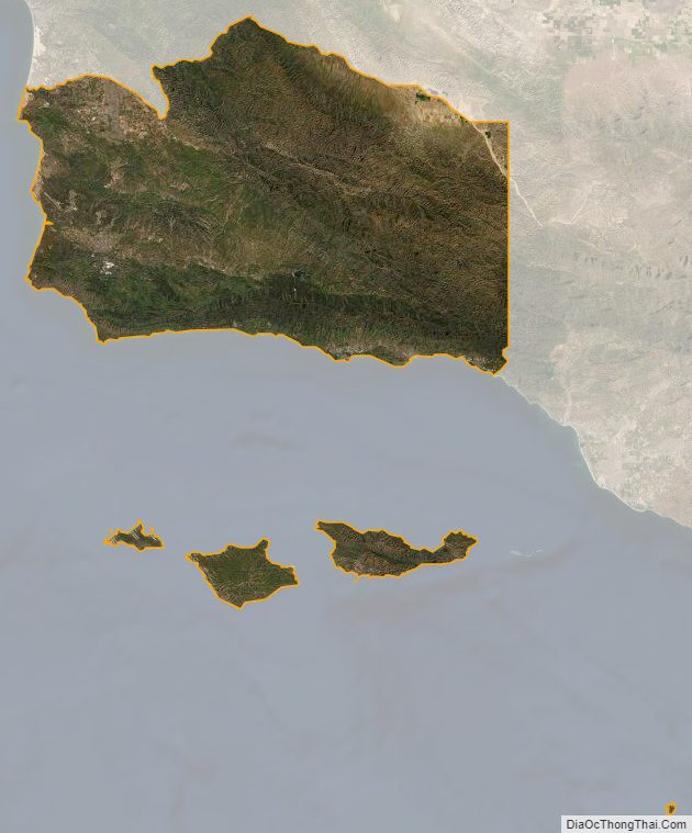
According to the U.S. Census Bureau, the county has a total area of 3,789 square miles (9,810 km), of which 2,735 square miles (7,080 km) is land and 1,054 square miles (2,730 km) (27.8%) is water. Four of the Channel Islands – San Miguel Island, Santa Cruz Island, Santa Rosa Island and Santa Barbara Island – are in Santa Barbara County. They form the largest part of the Channel Islands National Park (which also includes Anacapa Island in Ventura County).
Santa Barbara County has a mountainous interior abutting several coastal plains on the west and south coasts of the county. The largest concentration of population is on the southern coastal plain, referred to as the “south coast” – meaning the part of the county south of the Santa Ynez Mountains. This region includes the cities of Santa Barbara, Goleta, and Carpinteria, as well as the unincorporated areas of Hope Ranch, Summerland, Mission Canyon, Montecito, and Isla Vista, along with stretches of unincorporated area such as Noleta. North of the Santa Ynez range in the Santa Ynez Valley are the towns of Solvang, Buellton, and Lompoc; the unincorporated towns of Santa Ynez, Los Olivos and Ballard; the unincorporated areas of Mission Hills and Vandenberg Village; and Vandenberg Space Force Base, where the Santa Ynez River flows out to the sea. North of the Santa Ynez Valley are the cities of Santa Maria and Guadalupe, and the unincorporated towns of Orcutt, Los Alamos, Casmalia, Garey, and Sisquoc. In the extreme northeastern portion of the county are the small cities of New Cuyama, Cuyama, and Ventucopa. As of January 1, 2006, Santa Maria has become the largest city in Santa Barbara County.
The principal mountain ranges of the county are the Santa Ynez Mountains in the south, and the San Rafael Mountains and Sierra Madre Mountains in the interior and northeast. Most of the mountainous area is within the Los Padres National Forest, and includes two wilderness areas: the San Rafael Wilderness and the Dick Smith Wilderness. The highest elevation in the county is 6820 feet (2079 m) at Big Pine Mountain in the San Rafaels.
North of the mountains is the arid and sparsely populated Cuyama Valley, portions of which are in San Luis Obispo and Ventura Counties. Oil production, ranching, and agriculture dominate the land use in the privately owned parts of the Cuyama Valley; the Los Padres National Forest is adjacent to the south, and regions to the north and northeast are owned by the Bureau of Land Management and the Nature Conservancy.
Channel Islands
The four Channel Islands in Santa Barbara County are Santa Barbara Island, San Miguel Island, Santa Rosa Island, and the large Santa Cruz Island. All of them contain native and endemic wildlife, like the island oak and Torrey Pine. All four have the deer mouse living on them, the three latter, the island fox, and the two latter, the island spotted skunk. There used to be skunks on San Miguel Island, but due to predation from marine life, birds, and foxes, the San Miguel Island skunk has gone extinct.
Climate
Santa Barbara County has a mild warm-summer Mediterranean climate. Along the coast, temperatures rarely exceeds 100 °F (38 °C) in the summer, but rarely dip below freezing in winter. In the interior, however, summertime temperatures can soar over 100 °F (38 °C). Above 2,000 feet (610 meters), temperatures can frequently fall below freezing during the winter months. The area experiences nearly all of its rainfall during the winter months, and rarely sees any rain at all during the summer months.
The area’s dry, warm summers often lead to high wildfire danger in the fall. An example of this is the massive Thomas Fire, which started in Ventura County and rapidly spread into southern Santa Barbara County in December 2017. At the time, the fire was the largest wildfire ever to burn in California in terms of geographical size, but was topped only eight months later in the Mendocino Complex Fire in northern California. Heavy rainfall occurred the following January, causing massive mudslides and debris flows from the steep, fire-denuded hillsides. The community of Montecito was especially hard-hit. As of February 3, 2018, 21 are known dead and 2 are still missing.
Air quality
Air quality in the county, unlike much of southern California, is generally good because of the prevailing winds off of the Pacific Ocean. The county is in attainment of federal standards for ozone and particulate matter. In July 2020 the county was designated as attainment for the state ozone standard, but it still does not attain the state PM10 standard.
Adjacent counties
- San Luis Obispo County (North).
- Kern County (Northeast).
- Ventura County (Southeast).
National protected areas
- Channel Islands National Park (part)
- Guadalupe-Nipomo Dunes National Wildlife Refuge (part)
- Los Padres National Forest (part)
- Burton Mesa Ecological Reserve
Santa Barbara County Topographic Map
Santa Barbara County Satellite Map
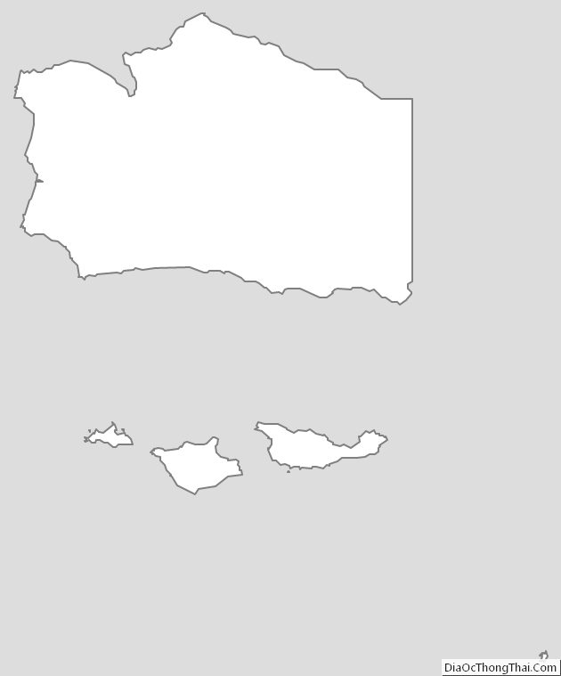
Santa Barbara County Outline Map