Santa Barbara (Spanish: Santa Bárbara, meaning ‘Saint Barbara’) is a coastal city in Santa Barbara County, California, of which it is also the county seat. Situated on a south-facing section of coastline, the longest such section on the West Coast of the United States, the city lies between the steeply rising Santa Ynez Mountains and the Pacific Ocean. Santa Barbara’s climate is often described as Mediterranean, and the city has been dubbed “The American Riviera”. According to the 2020 U.S. Census, the city’s population was 88,665.
In addition to being a popular tourist and resort destination, the city has a diverse economy that includes a large service sector, education, technology, health care, finance, agriculture, manufacturing, and local government. In 2004, the service sector accounted for 35% of local employment. Area institutions of higher learning include the University of California, Santa Barbara, Santa Barbara City College, Westmont College, and Antioch University. The city is served by Santa Barbara Airport and train service is provided by Amtrak, which operates the Pacific Surfliner, which runs from San Diego to San Luis Obispo. The Santa Barbara area is connected via U.S. Highway 101 to Los Angeles 100 mi (160 km) to the southeast and San Francisco 325 mi (525 km) to the northwest. Behind the city, in and beyond the Santa Ynez Mountains, is the Los Padres National Forest, which contains several remote wilderness areas. Channel Islands National Park and Channel Islands National Marine Sanctuary are located approximately 20 miles (30 km) offshore.
| Name: | Santa Barbara city |
|---|---|
| LSAD Code: | 25 |
| LSAD Description: | city (suffix) |
| State: | California |
| County: | Santa Barbara County |
| Incorporated: | April 9, 1850 |
| Elevation: | 49 ft (15 m) |
| Land Area: | 19.50 sq mi (50.51 km²) |
| Water Area: | 22.50 sq mi (58.27 km²) 53.61% |
| Population Density: | 4,546.92/sq mi (1,755.58/km²) |
| Area code: | 805 |
| FIPS code: | 0669070 |
| Website: | SantaBarbaraCA.gov |
Explore the city of Santa Barbara with this Santa Barbara map. Get to know the roads, highways, and things to do in the area. It also features an interactive map to see the downtown and surrounding area.
Santa Barbara is a picturesque coastal city located in southwest California. With its Mediterranean atmosphere, winding streets, and beautiful architecture, it’s a city that’s full of history and culture. The Mission Creek flows through Santa Barbara from the upland Rattlesnake Canyon Park. Enjoy the views of the Santa Ynez Mountains tucked away to the north of the city. Get to know Santa Barbara better with this map.
Online Interactive Map
Click on ![]() to view map in "full screen" mode.
to view map in "full screen" mode.
Get a sneak peek of what this city has to offer with this interactive map. With this guide, you’ll be able to see all the attractions, restaurants, and nightlife that are worth exploring. This interactive map will help you plan your route and find the best places to visit in Santa Barbara. From its cliffs and beaches to its architecture and wine, the city has something for everyone.
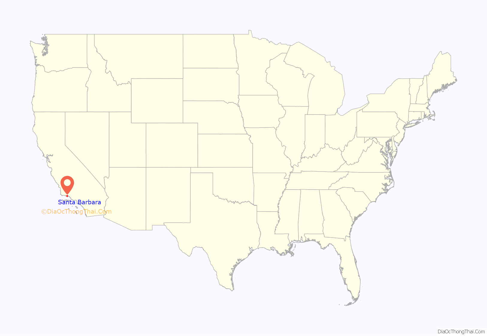
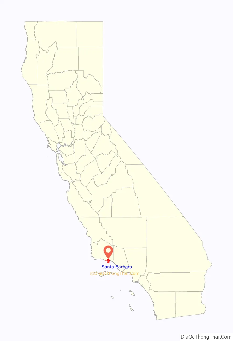
Santa Barbara location map. Where is Santa Barbara city?
History
Evidence of human habitation of the area begins at least 13,000 years ago. Evidence for a Paleoindian presence includes a fluted Clovis-like point found in the 1980s along the western Santa Barbara County coast, as well as the remains of Arlington Springs Man, found on Santa Rosa Island in the 1960s. At least 25,000 Chumash natives lived in the region prior to Spanish contact. Five Chumash villages flourished in the area. The present-day area of Santa Barbara City College was the village of Mispu; the site of the Los Baños pool (along west beach) was the village of Syukhtun, chief Yanonalit’s large village located between Bath and Chapala streets; Amolomol was at the mouth of Mission Creek; and Swetete, above the bird refuge.
Spanish era
Spanish explorer Juan Rodríguez Cabrillo, sailing for the Kingdom of Spain, sailed through what is now called the Santa Barbara Channel in 1542, anchoring briefly in the area. In 1602, Spanish maritime explorer Sebastián Vizcaíno gave the name “Santa Barbara” to the channel and also to one of the Channel Islands.
A land expedition led by Gaspar de Portolà visited around 1769, and Franciscan missionary Juan Crespi, who accompanied the expedition, named a large native town “Laguna de la Concepcion”. Cabrillo’s earlier name, however, is the one that has survived.
The first permanent European residents were Spanish missionaries and soldiers under Felipe de Neve, who arrived in 1782 and constructed the Presidio. They were sent to both secure the Spanish claim to the region and to convert the indigenous peoples to Catholicism. Many of the Spaniards brought their families with them, and those formed the nucleus of the small town – at first just a cluster of adobes – that surrounded the Presidio of Santa Barbara. The Santa Barbara Mission was established on the Feast of Saint Barbara, December 4, 1786. It was the tenth of the California Missions to be founded by the Spanish Franciscans. It was dedicated by Padre Fermín Lasuén, who succeeded Padre Junipero Serra as the second president and founder of the California Franciscan Mission Chain. The Chumash laborers built a connection between the canyon creek and the Santa Barbara Mission water system through the use of a dam and an aqueduct. During the following decades, many of the natives died of diseases such as smallpox, against which they had no natural immunity.
The most dramatic event of the Spanish period was the powerful 1812 earthquake, and tsunami, with an estimated magnitude of 7.1, which destroyed the Mission as well as the rest of the town; water reached as high as present-day Anapamu street, and carried a ship half a mile up Refugio Canyon. The Mission was rebuilt by 1820 after the earthquake. Following the earthquake, the Mission fathers chose to rebuild in a grander manner, and it is this construction that survives to the present day, the best-preserved of the California Missions, and still functioning as an active church by the Franciscans. After the Mexican government secularized the missions in the 1830s, the baptismal, marriage, and burial records of other missions were transferred to Santa Barbara, and now found in the Santa Barbara Mission Archive-Library.
The Spanish period ended in 1822 with the conclusion of the Mexican War of Independence, which terminated 300 years of Spanish colonial rule and transferred control to the newly independent Mexican government.
Santa Barbara street names reflect the influence of the Spanish period. The names de le Guerra and Carrillo come from the Guerra family of California and Carrillo family of California. They were instrumental in building up the town, so they were honored by having streets named after them.
Mexican era
After the forced secularization of the Missions in 1833, successive Mexican Governors distributed the large land tracts formerly held by the Franciscan Order to various families in order to reward service or build alliances. These land grants to local notable families mark the beginning of the “Rancho Period” in California and Santa Barbara history. Fernando Tico was one of the first settlers who received land grants for the local area. Fernando led the Native Americans against the Argentinian pirates in the 1800s. The population remained sparse, with enormous cattle operations run by wealthy families. It was during this period that Richard Henry Dana, Jr. first visited Santa Barbara and wrote about the culture and people of Santa Barbara in his book Two Years Before the Mast.
Santa Barbara fell bloodlessly to a battalion of American soldiers under John C. Frémont on December 27, 1846, during the Mexican–American War, and after the Treaty of Guadalupe Hidalgo in 1848 it became part of the expanding United States.
Post-Conquest era
Change came quickly in Santa Barbara following the American Conquest of California. The population doubled between 1850 and 1860. In 1851, land surveyor Salisbury Haley designed the street grid, famously botching the block measurements, misaligning the streets, thereby creating doglegs at certain intersections. Wood construction replaced adobe as American settlers moved in; during the Gold Rush years and following, the town became a haven for bandits and gamblers, and a dangerous and lawless place. Charismatic gambler and highwayman Jack Powers had virtual control of the town in the early 1850s, until driven out by a posse organized in San Luis Obispo. English gradually supplanted Spanish as the language of daily life, becoming the language of official record in 1870. The first newspaper, the Santa Barbara Gazette, was founded in 1855.
While the Civil War had little effect on Santa Barbara, the disastrous drought of 1863 ended the Rancho Period, as most of the cattle died and ranchos were broken up and sold. Mortimer Cook, a wealthy entrepreneur, arrived in 1871 and opened the city’s first bank. Cook later served two terms as mayor. Cook founded the first National Gold Bank of Santa Barbara in 1873. The building of Stearns Wharf in 1872 enhanced Santa Barbara’s commercial and tourist accessibility; previously goods and visitors had to transfer from steamboats to smaller craft to row ashore. During the 1870s, writer Charles Nordhoff promoted the town as a health resort and destination for well-to-do travelers from other parts of the U.S.; many of them came, and many stayed. The luxurious Arlington Hotel dated from this period. In 1887 the railroad finally went through to Los Angeles, and in 1901 to San Francisco: Santa Barbara was now easily accessible by land and by sea, and subsequent development was brisk. Santa Barbara had a system of street railways that operated from 1875 through 1929. Begun as a single mule-drawn line from the waterfront pier to the Arlington Hotel, over the decades it was incrementally expanded, later electrified, and operated until its closure in June 1929.
Peter J. Barber, an architect, designed many Late Victorian style residences, and served twice as mayor, in 1880 and again in 1890. A year after Barber’s term as mayor, President Benjamin Harrison became the first of five presidents to visit Santa Barbara.
Early 20th century to World War II
Just before the turn of the 20th century, oil was discovered at the Summerland Oil Field, and the region along the beach east of Santa Barbara sprouted numerous oil derricks and piers for drilling offshore. This was the first offshore oil development in the world; oil drilling offshore would become a contentious practice in the Santa Barbara area, which continues to the present day.
Santa Barbara housed the world’s largest movie studio during the era of silent film. Flying A Studios, a division of the American Film Manufacturing Company, operated on two city blocks centered at State and Mission between 1910 and 1922, with the industry shutting down locally and moving to Hollywood once it outgrew the area, needing the resources of a larger city. Flying A and the other smaller local studios produced approximately 1,200 films during their tenure in Santa Barbara, of which approximately 100 survive.
During this period, the Loughead Aircraft Company was established on lower State Street, and regularly tested seaplanes off of East Beach. This was the genesis of what would later become Lockheed.
The magnitude 6.3 earthquake of June 29, 1925, the first destructive earthquake in California since the 1906 San Francisco quake, destroyed much of downtown Santa Barbara and killed 13 people. The earthquake caused infrastructure to collapse including the Sheffield Dam. The low death toll is attributed to the early hour (6:44 a.m., before most people were out on the streets, vulnerable to falling masonry). While this quake, like the one in 1812, was centered in the Santa Barbara Channel, it caused no tsunami. It came at an opportune time for rebuilding, since a movement for architectural reform and unification around a Spanish Colonial style was already underway. Under the leadership of Pearl Chase, many of the city’s famous buildings rose as part of the rebuilding process, including the Santa Barbara County Courthouse, sometimes praised as the “most beautiful public building in the United States.” In 1907 in northern Santa Barbara county a horrific train accident claimed the lives of 37, the exact cause of which is still unknown. It is still the deadliest disaster in the Santa Barbara history.
During World War II, Santa Barbara was home to Marine Corps Air Station Santa Barbara, and Naval Reserve Center Santa Barbara at the harbor. Up the coast, west of the city, was the Army’s Camp Cooke (the present-day Vandenberg Space Force Base). In the city, Hoff General Hospital treated servicemen wounded in the Pacific Theatre. On February 23, 1942, not long after the outbreak of war in the Pacific, the Japanese submarine I-17 surfaced offshore and lobbed 16 shells at the Ellwood Oil Field, about 10 miles (15 km) west of Santa Barbara, in the first shelling attack by an enemy power on the continental U.S. since the bombardment of Orleans in World War I. Although the shelling was inaccurate and only caused about $500 damage to a catwalk, panic was immediate. Many Santa Barbara residents fled, and land values plummeted to historic lows.
After World War II
After the war many of the servicemen who had seen Santa Barbara returned to stay. The population surged by 10,000 people between the end of the war and 1950. This burst of growth had dramatic consequences for the local economy and infrastructure. Highway 101 was built through town during this period, and newly built Lake Cachuma began supplying water via a tunnel dug through the mountains between 1950 and 1956.
Local relations with the oil industry gradually soured through the period. Production at Summerland had ended, Elwood was winding down, and to find new fields oil companies carried out seismic exploration of the Channel using explosives, a controversial practice that local fishermen claimed harmed their catch. The culminating disaster, and one of the formative events in the modern environmental movement, was the blowout at Union Oil’s Platform A on the Dos Cuadras Field, about eight miles (13 km) southeast of Santa Barbara in the Santa Barbara Channel, on January 28, 1969. Approximately 100,000 barrels (16,000 m) of oil surged out of a huge undersea break, fouling hundreds of square miles of ocean and all the coastline from Ventura to Goleta, as well north facing beaches on the Channel Islands. Two legislative consequences of the spill in the next year were the passages of the California Environmental Quality Act (CEQA) and the National Environmental Policy Act (NEPA); locally, outraged citizens formed GOO (Get Oil Out). Santa Barbara’s business community strove to attract development until the surge in the anti-growth movement in the 1970s. Many “clean” industries, especially aerospace firms such as Raytheon and Delco Electronics, moved to town in the 1950s and 1960s, bringing employees from other parts of the U.S. UCSB itself became a major employer. In 1975, the city passed an ordinance restricting growth to a maximum of 85,000 residents, through zoning. Growth in the adjacent Goleta Valley could be shut down by denying water meters to developers seeking permits. As a result of these changes, growth slowed down, but prices rose sharply.
When voters approved connection to State water supplies in 1991, parts of the city, especially outlying areas, resumed growth, but more slowly than during the boom period of the 1950s and 1960s. While the slower growth preserved the quality of life for most residents and prevented the urban sprawl notorious in the Los Angeles basin, housing in the Santa Barbara area was in short supply, and prices soared: in 2006, only six percent of residents could afford a median-value house. As a result, many people who work in Santa Barbara commute from adjacent, more affordable areas, such as Santa Maria, Lompoc, and Ventura. The resultant traffic on incoming arteries, in particular the stretch of Highway 101 between Ventura and Santa Barbara, is another problem being addressed by long-range planners.
Since the middle of the twentieth century, several destructive fires have affected Santa Barbara: the 1964 Coyote Fire, which burned 67,000 acres (270 km) of backcountry along with 106 homes; the smaller, but quickly moving, Sycamore Fire in 1977, which burned 200 homes; the disastrous 1990 Painted Cave Fire, which incinerated over 500 homes in only several hours, during an intense Sundowner wind event; the November 2008 Tea Fire, which destroyed 210 homes in the foothills of Santa Barbara and Montecito; and the 2009 Jesusita Fire that burned 8,733 acres (35.34 km) and destroyed 160 homes above the San Roque region of Santa Barbara.
The Thomas Fire burned from its origins in Santa Paula 60 miles (100 km) to the east of Santa Barbara and consumed 281,893 acres (1,140.78 km) in Santa Barbara and Ventura counties, most of which consisted of rural land and wilderness areas. The fire started December 4, 2017, and was 100% contained by January 12, 2018. 1,050 structures were lost in the Thomas Fire, mostly east of Santa Barbara in Ventura County. The Thomas Fire has been the largest Santa Barbara County fire ever recorded to date.
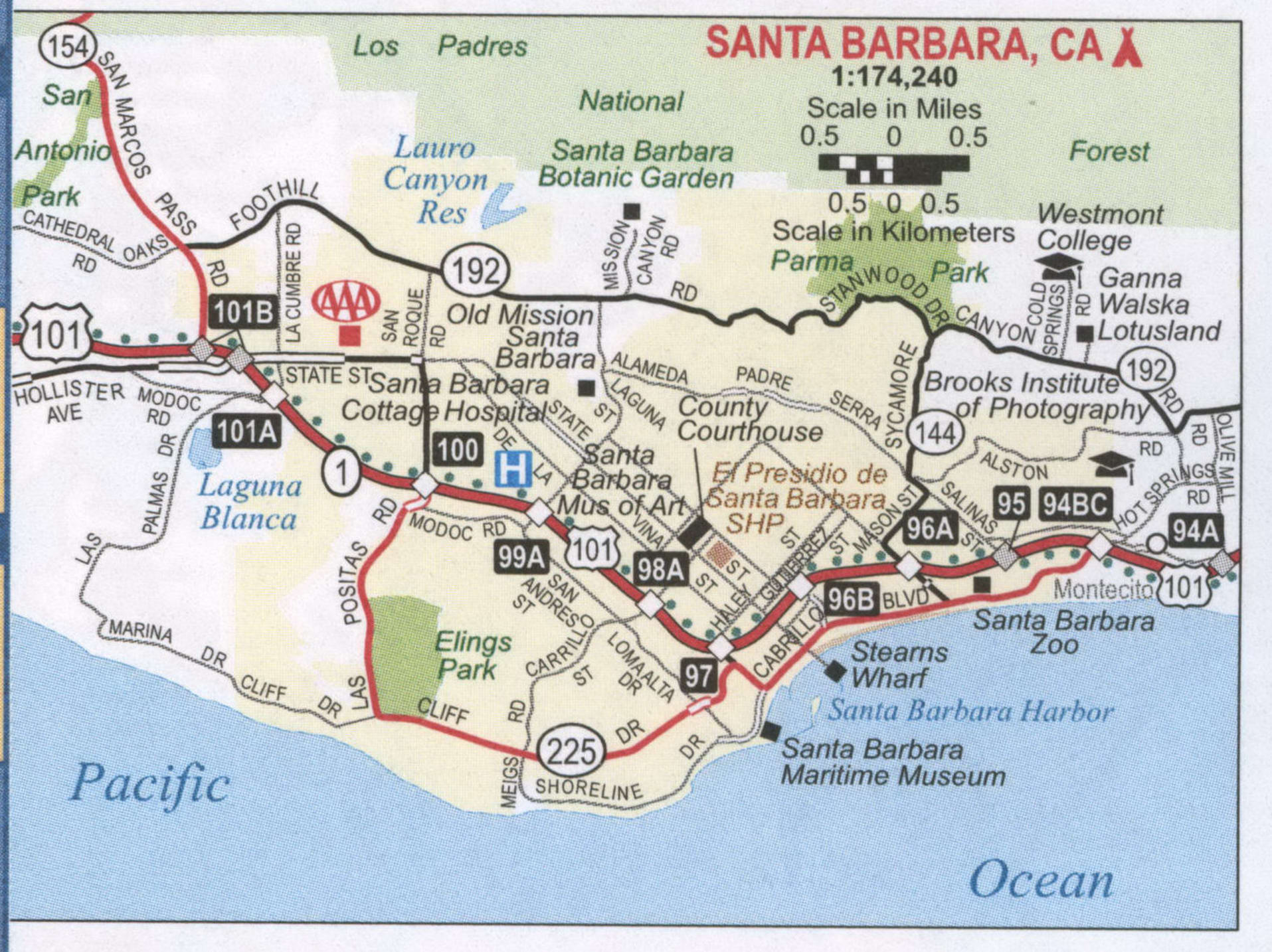
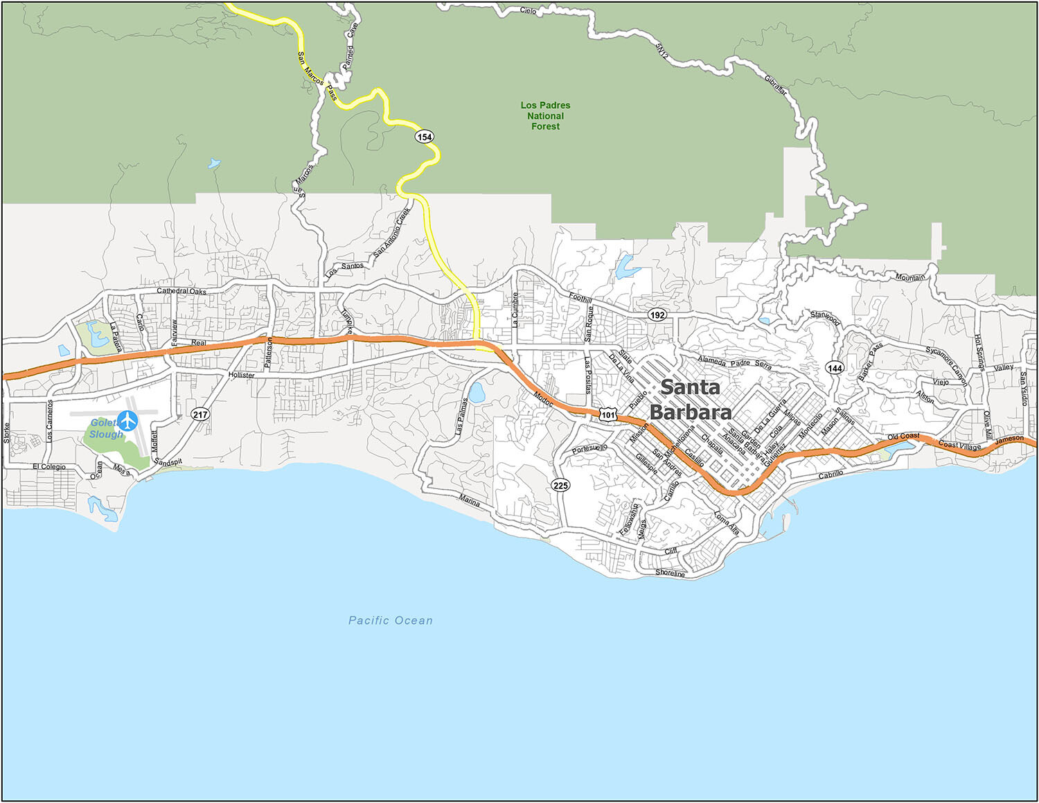
Santa Barbara Road Map
Taking the time to explore Santa Barbara is a great way to get to know the city and its history. This Santa Barbara road map will help you plan your trip, and it will include all the interstates, state highways, and major roads that you need to know about. Get a quick, easy overview of Santa Barbara with this printable map. But for any travel outside the city, you can refer to our California road map for highway information.
US Highways: 101, 144, 154, 192, 225, Coast Village Hwy,
Major Roads: Cabrillo Blvd, Cliff Dr, Coast Village Rd, Fairview Ave, Foothill Rd, Fowler Rd, Hollister Ave, Las Positas Rd, Loma Alta Dr, Los Patos Way, Mason St, Milpas St, Mission Ridge Rd, Moffett Pl, Mountain Dr, Real, Salinas St, San Roque Rd, Shoreline Dr, Stanwood Dr, State St, Sycamore Canyon Rd
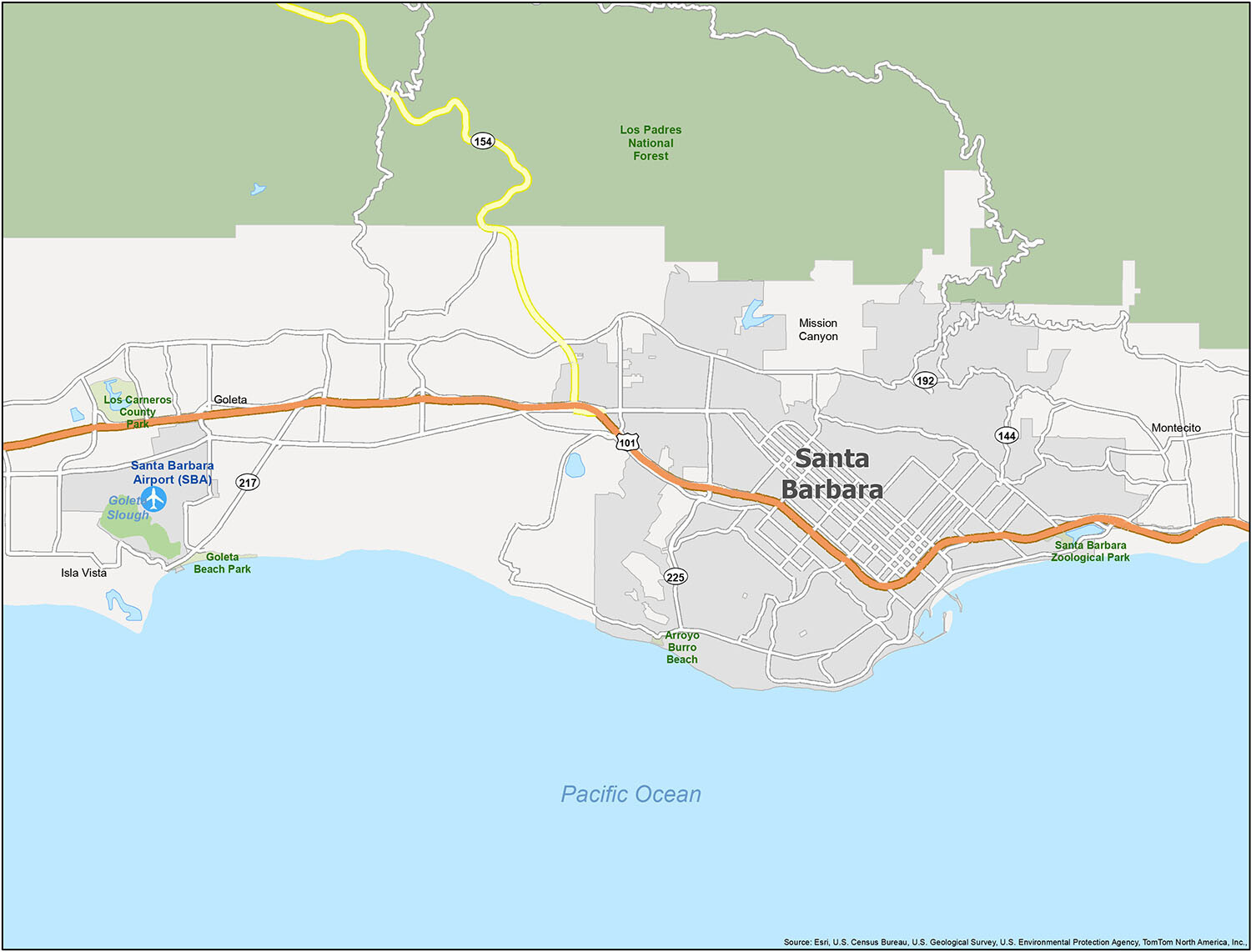
Explore Santa Barbara with a Reference Map
Are you planning a trip to Santa Barbara? Get a preview of the city before you go with this reference map! This map shows you the parks, forests, and populated areas in Santa Barbara so you can get a better understanding of the city. From the Santa Barbara Airport (SBA) to the Santa Barbara Zoological Park, this map will give you a crash course on Santa Barbara that you can take on your trip.
Cities: Goleta, Santa Barbara
Census-designated place (CDP): Isla Vista, Mission Canyon, Montecito
Parks/Forests: Arroyo Burro Beach, Goleta Beach Park, Los Carneros County Park, Los Padres National Forest, Santa Barbara Zoological Park
Water Features: Goleta Slough, Pacific Ocean
10 things to do in Santa Barbara city
If you’re planning a trip to Santa Barbara, then you’re in for a treat! From the iconic Mission landmark to the stunning beaches, you’ll find plenty of amazing things to do in Santa Barbara. From Stearns Wharf to Lotusland, these are some of the top sights and attractions that you’ll find in Santa Barbara.
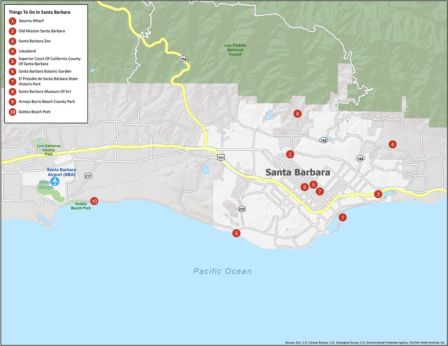
10 Things to Do in Santa Barbara
Santa Barbara is known for its beaches, surfing, and iconic Mission landmark. If you ever travel to Santa Barbara, we highly recommend these 10 things to do.
- Stearns Wharf
- Old Mission Santa Barbara
- Santa Barbara Zoo
- Lotusland
- Superior Court Of California County Of Santa Barbara
- Santa Barbara Botanic Garden
- El Presidio de Santa Bárbara State Historic Park
- Santa Barbara Museum Of Art
- Arroyo Burro Beach County Park
- Goleta Beach Park
If you’re planning a trip to Santa Barbara, then you’re in for a treat! From the iconic Mission landmark to the stunning beaches, you’ll find plenty of amazing things to do in Santa Barbara. From Stearns Wharf to Lotusland, these are some of the top sights and attractions that you’ll find in Santa Barbara.
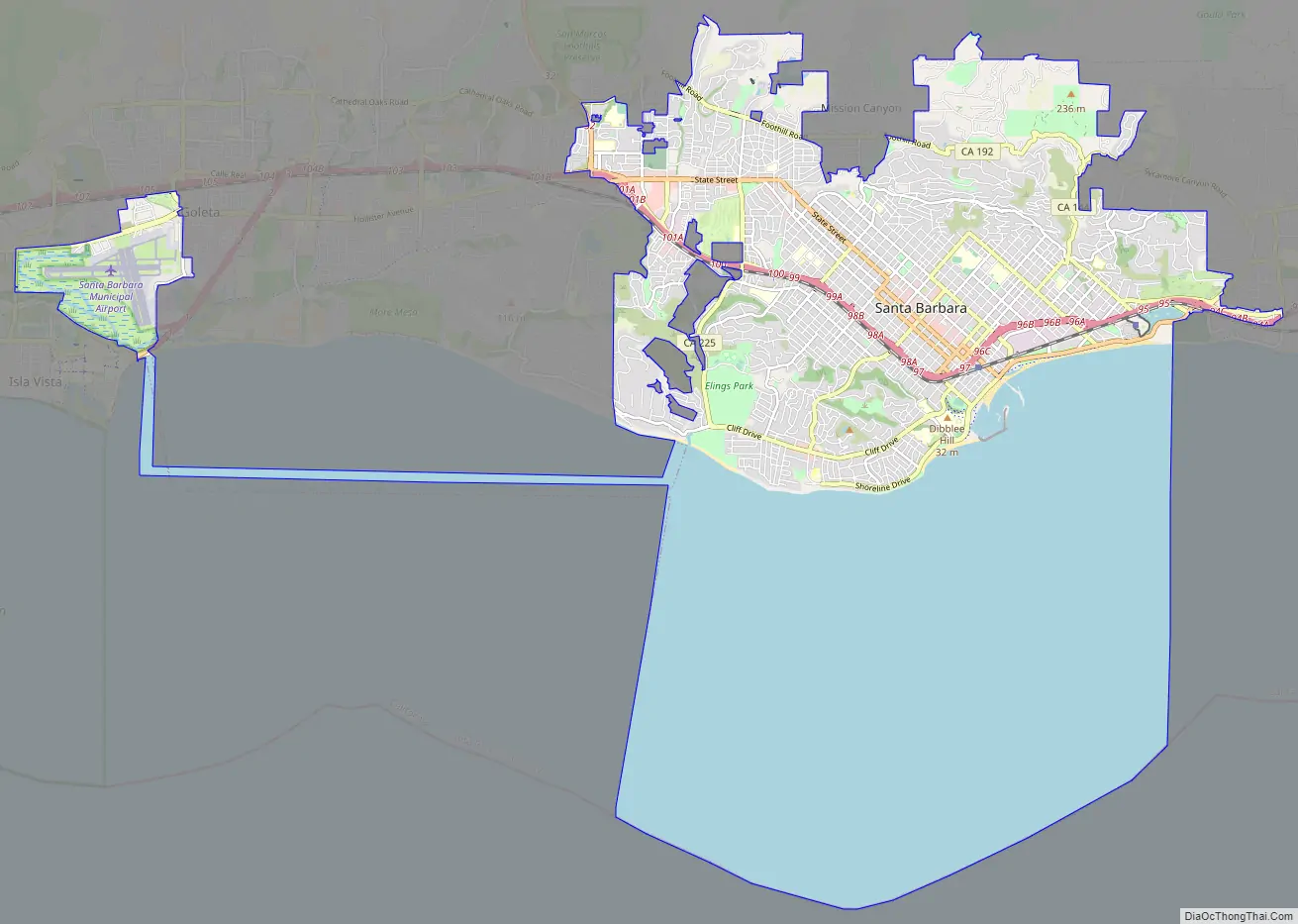
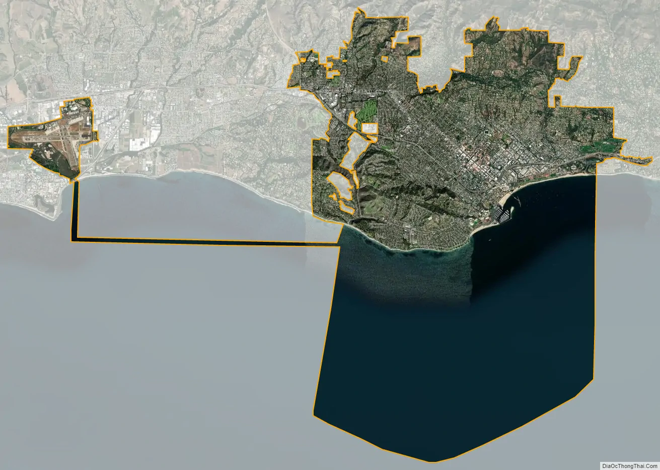
Santa Barbara city Satellite Map
Geography
Santa Barbara is located about 90 miles (145 km) west-northwest of Los Angeles, along the Pacific coast. This stretch of coast along southern Santa Barbara County is sometimes referred to as “The American Riviera”, presumably because its geography and climate are similar to that of areas along the northern Mediterranean Sea coast (especially in southern France) known as the Riviera. The Santa Ynez Mountains, an east–west trending range, rise dramatically behind the city, with several peaks exceeding 4,000 feet (1,200 m). Covered with chaparral, oaks and sandstone outcrops, they make a scenic backdrop to the town. Sometimes, perhaps once every three years, snow falls on the mountains, but it rarely stays for more than a few days. Nearer to town, directly east and adjacent to Mission Santa Barbara, is an east–west ridge known locally as “the Riviera,” traversed by a road called “Alameda Padre Serra” (shortened APS, which translates to “Father Serra’s pathway”).
According to the United States Census Bureau, the city has a total area of 42.0 square miles (108.8 km), of which 19.5 square miles (51 km) of it is land and 22.5 square miles (58 km) of it (53.61%) is water. The high official figures for water is due to the extension of the city limit into the ocean, including a strip of city reaching out into the sea and inland again to keep the Santa Barbara Airport (SBA) within the city boundary.
See also
Map of California State and its subdivision:- Alameda
- Alpine
- Amador
- Butte
- Calaveras
- Colusa
- Contra Costa
- Del Norte
- El Dorado
- Fresno
- Glenn
- Humboldt
- Imperial
- Inyo
- Kern
- Kings
- Lake
- Lassen
- Los Angeles
- Madera
- Marin
- Mariposa
- Mendocino
- Merced
- Modoc
- Mono
- Monterey
- Napa
- Nevada
- Orange
- Placer
- Plumas
- Riverside
- Sacramento
- San Benito
- San Bernardino
- San Diego
- San Francisco
- San Joaquin
- San Luis Obispo
- San Mateo
- Santa Barbara
- Santa Clara
- Santa Cruz
- Shasta
- Sierra
- Siskiyou
- Solano
- Sonoma
- Stanislaus
- Sutter
- Tehama
- Trinity
- Tulare
- Tuolumne
- Ventura
- Yolo
- Yuba
- Alabama
- Alaska
- Arizona
- Arkansas
- California
- Colorado
- Connecticut
- Delaware
- District of Columbia
- Florida
- Georgia
- Hawaii
- Idaho
- Illinois
- Indiana
- Iowa
- Kansas
- Kentucky
- Louisiana
- Maine
- Maryland
- Massachusetts
- Michigan
- Minnesota
- Mississippi
- Missouri
- Montana
- Nebraska
- Nevada
- New Hampshire
- New Jersey
- New Mexico
- New York
- North Carolina
- North Dakota
- Ohio
- Oklahoma
- Oregon
- Pennsylvania
- Rhode Island
- South Carolina
- South Dakota
- Tennessee
- Texas
- Utah
- Vermont
- Virginia
- Washington
- West Virginia
- Wisconsin
- Wyoming


