Los Alamos (Spanish: Los Álamos, meaning The Cottonwoods) is an unincorporated community in Santa Barbara County, California, United States. Located in the Los Alamos Valley, the town of Los Alamos is considered to be a part of the Santa Ynez Valley community. Los Alamos is also connected to other cities Vandenberg SFB, Lompoc, Buellton, Solvang, and other Santa Barbara County cities. It is 140 miles (230 kilometres) northwest of Los Angeles and 281 miles (452 km) south of San Francisco. The population was 1,890 at the 2010 census, up from 1,372 at the 2000 census. For statistical purposes, the United States Census Bureau has defined Los Alamos as a census-designated place (CDP).
| Name: | Los Alamos CDP |
|---|---|
| LSAD Code: | 57 |
| LSAD Description: | CDP (suffix) |
| State: | California |
| County: | Santa Barbara County |
| Elevation: | 568 ft (174 m) |
| Total Area: | 3.869 sq mi (10.019 km²) |
| Land Area: | 3.868 sq mi (10.018 km²) |
| Water Area: | 0.001 sq mi (0.002 km²) 0.02% |
| Total Population: | 1,890 |
| Population Density: | 490/sq mi (190/km²) |
| ZIP code: | 93440 |
| Area code: | 805 |
| FIPS code: | 0643252 |
Online Interactive Map
Click on ![]() to view map in "full screen" mode.
to view map in "full screen" mode.
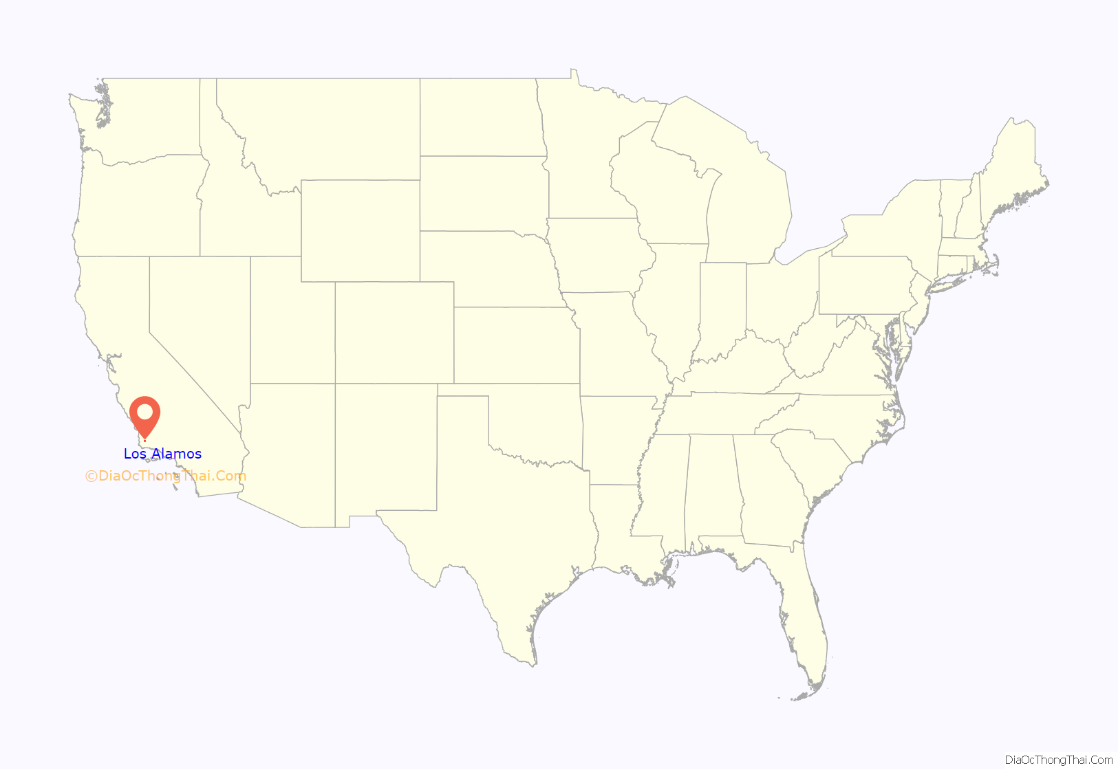
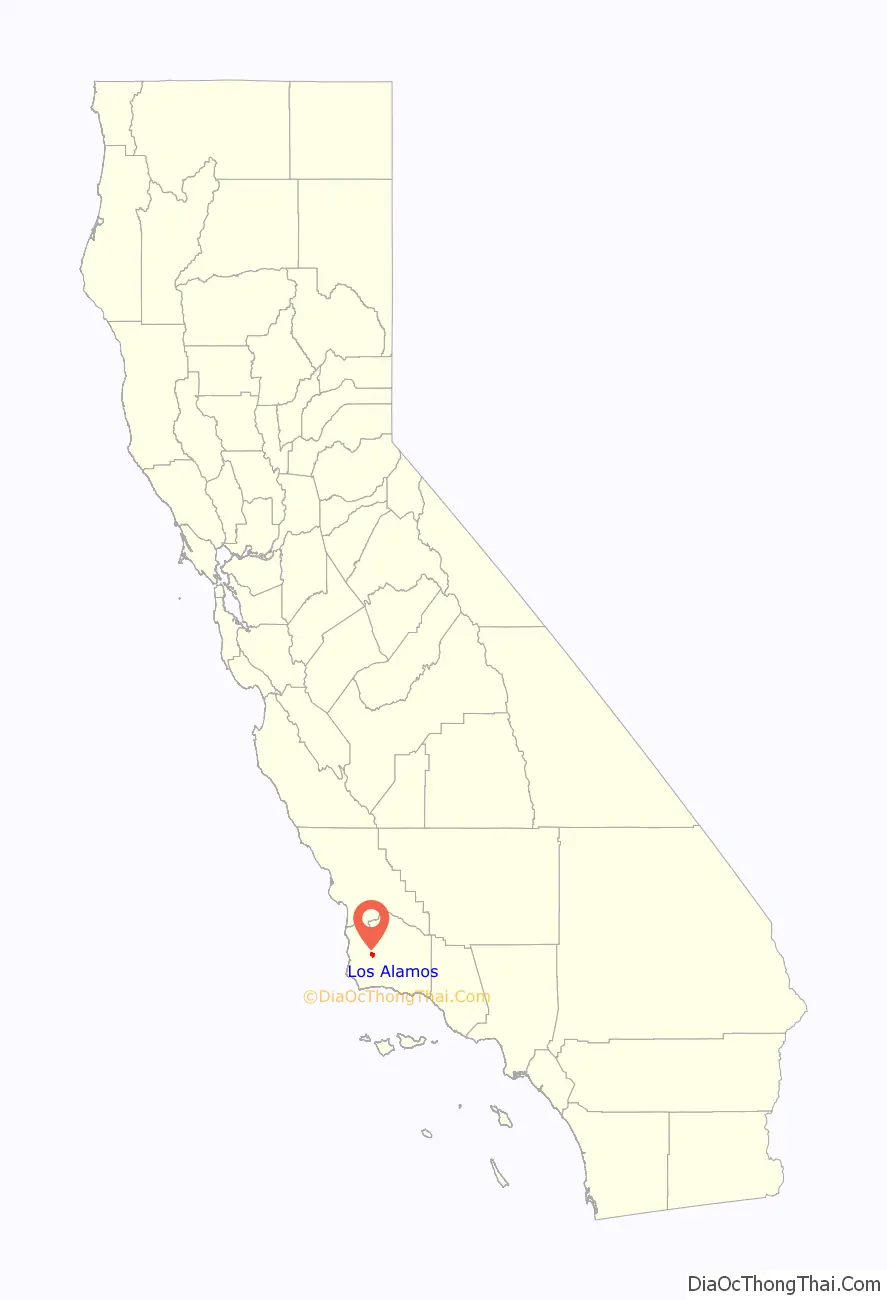
Los Alamos location map. Where is Los Alamos CDP?
History
In 1839, José Antonio de la Guerra, a son of José de la Guerra y Noriega received the Rancho Los Alamos Mexican land grant. The hills above Rancho Los Alamos served as a hideout for bandito, Salomon Pico, whose escapades were popularized by the character “Zorro”. During the U.S.’s centennial year of 1876, Thomas Bell along with his nephew John S. Bell, and Dr. James B. Shaw (all from San Francisco), purchased acreage from Rancho Los Alamos and neighboring Rancho La Laguna. Both families allocated a half square mile from each of their new ranches to create the Los Alamos town site with “Centennial Street” as the central thoroughfare.
The Los Alamos Valley prospered and grew quickly serving as a popular stagecoach stop from 1861 to 1901. The Union Hotel opened in 1880 to serve overnight travelers. The narrow-gauge Pacific Coast Railway also ran to Los Alamos from San Luis Obispo between 1882 and 1940. Oil was discovered at the Orcutt field in the hills north of Valley in 1901, and in the Purisima Hills south of the valley at the Lompoc Oil Field in 1903, providing more economic prosperity. The town flagpole at Centennial and Bell Street was dedicated in 1918. The Chamber of Commerce was active from 1920 to 1932 and instrumental in forming a lighting district, obtaining telephone service, street paving and mail service. Residents today still pick-up their mail from the Post Office downtown, as no street delivery is available.
Los Alamos, California, is home to the last standing Pacific Coast Railroad Station, and is now also home to various wine tasting rooms, fine dining establishments, and antique stores.
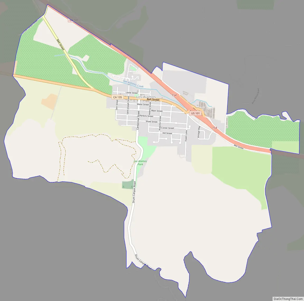
Los Alamos Road Map
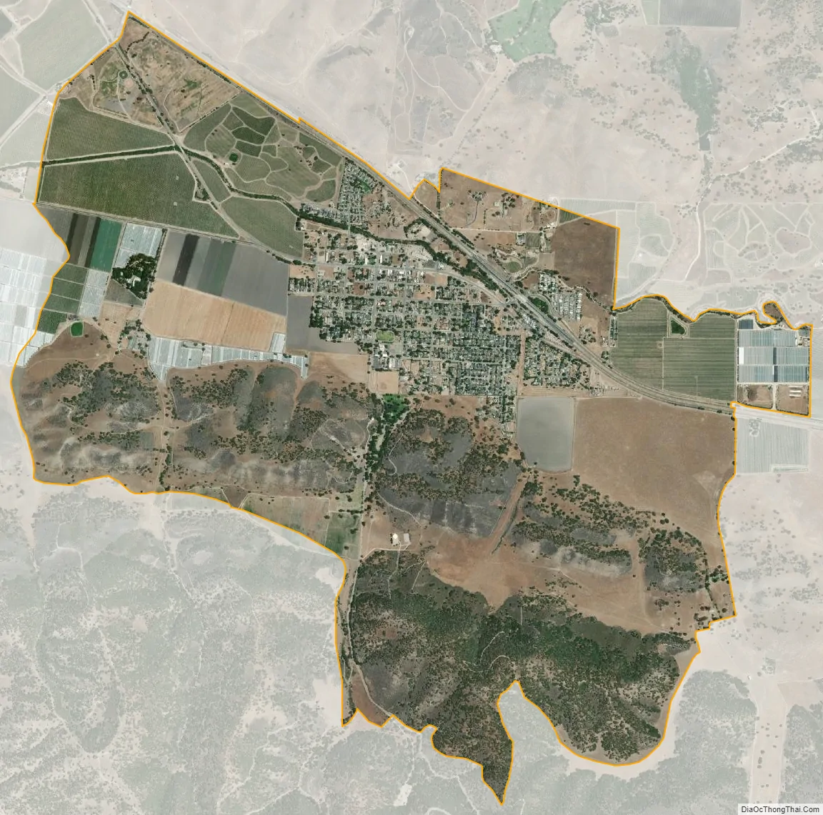
Los Alamos city Satellite Map
Geography
According to the United States Census Bureau, the CDP has a total area of 3.9 square miles (10 square kilometres), 99.98 percent of it land and 0.02 percent of it water.
Los Alamos is located near the Santa Ynez Valley in the heart of the Santa Barbara wine country, on U.S. Route 101. While Los Alamos is in a narrow valley, the surrounding terrain consists of rolling hills.
Los Alamos is located off U.S. Route 101 about 10 miles (16 km) north of Buellton, and 15 miles (24 km) south of Santa Maria. Los Alamos is approximately 140 miles (230 km) northwest of Los Angeles and 281 miles (452 km) south of San Francisco.
Los Alamos is relatively isolated. It is about 10 miles (16 km) to Buellton, California, and Solvang, California and Los Olivos, California to the southeast, Guadalupe, Orcutt and Santa Maria, California to the northwest along Highway 101, 135, Vandenberg Road and Cabrillo Highway. Lompoc, California and Vandenberg Air Force Base are to the west and southwest, respectively. California State Route 135 is the main road to the base. The large Cat Canyon Oil Field is in the hills to the northeast, the Zaca Oil Field to the east-southeast, and the Orcutt Oil Field is in the hills to the northwest of the town.
San Antonio Creek passes through the town on the way to the ocean.
Climate
This region experiences warm (but not hot) and dry summers, with no average monthly temperatures above 83 degrees Fahrenheit (28 degrees Celsius). According to the Köppen Climate Classification system, Los Alamos has a warm-summer Mediterranean climate, abbreviated “Csb” on climate maps.
See also
Map of California State and its subdivision:- Alameda
- Alpine
- Amador
- Butte
- Calaveras
- Colusa
- Contra Costa
- Del Norte
- El Dorado
- Fresno
- Glenn
- Humboldt
- Imperial
- Inyo
- Kern
- Kings
- Lake
- Lassen
- Los Angeles
- Madera
- Marin
- Mariposa
- Mendocino
- Merced
- Modoc
- Mono
- Monterey
- Napa
- Nevada
- Orange
- Placer
- Plumas
- Riverside
- Sacramento
- San Benito
- San Bernardino
- San Diego
- San Francisco
- San Joaquin
- San Luis Obispo
- San Mateo
- Santa Barbara
- Santa Clara
- Santa Cruz
- Shasta
- Sierra
- Siskiyou
- Solano
- Sonoma
- Stanislaus
- Sutter
- Tehama
- Trinity
- Tulare
- Tuolumne
- Ventura
- Yolo
- Yuba
- Alabama
- Alaska
- Arizona
- Arkansas
- California
- Colorado
- Connecticut
- Delaware
- District of Columbia
- Florida
- Georgia
- Hawaii
- Idaho
- Illinois
- Indiana
- Iowa
- Kansas
- Kentucky
- Louisiana
- Maine
- Maryland
- Massachusetts
- Michigan
- Minnesota
- Mississippi
- Missouri
- Montana
- Nebraska
- Nevada
- New Hampshire
- New Jersey
- New Mexico
- New York
- North Carolina
- North Dakota
- Ohio
- Oklahoma
- Oregon
- Pennsylvania
- Rhode Island
- South Carolina
- South Dakota
- Tennessee
- Texas
- Utah
- Vermont
- Virginia
- Washington
- West Virginia
- Wisconsin
- Wyoming


