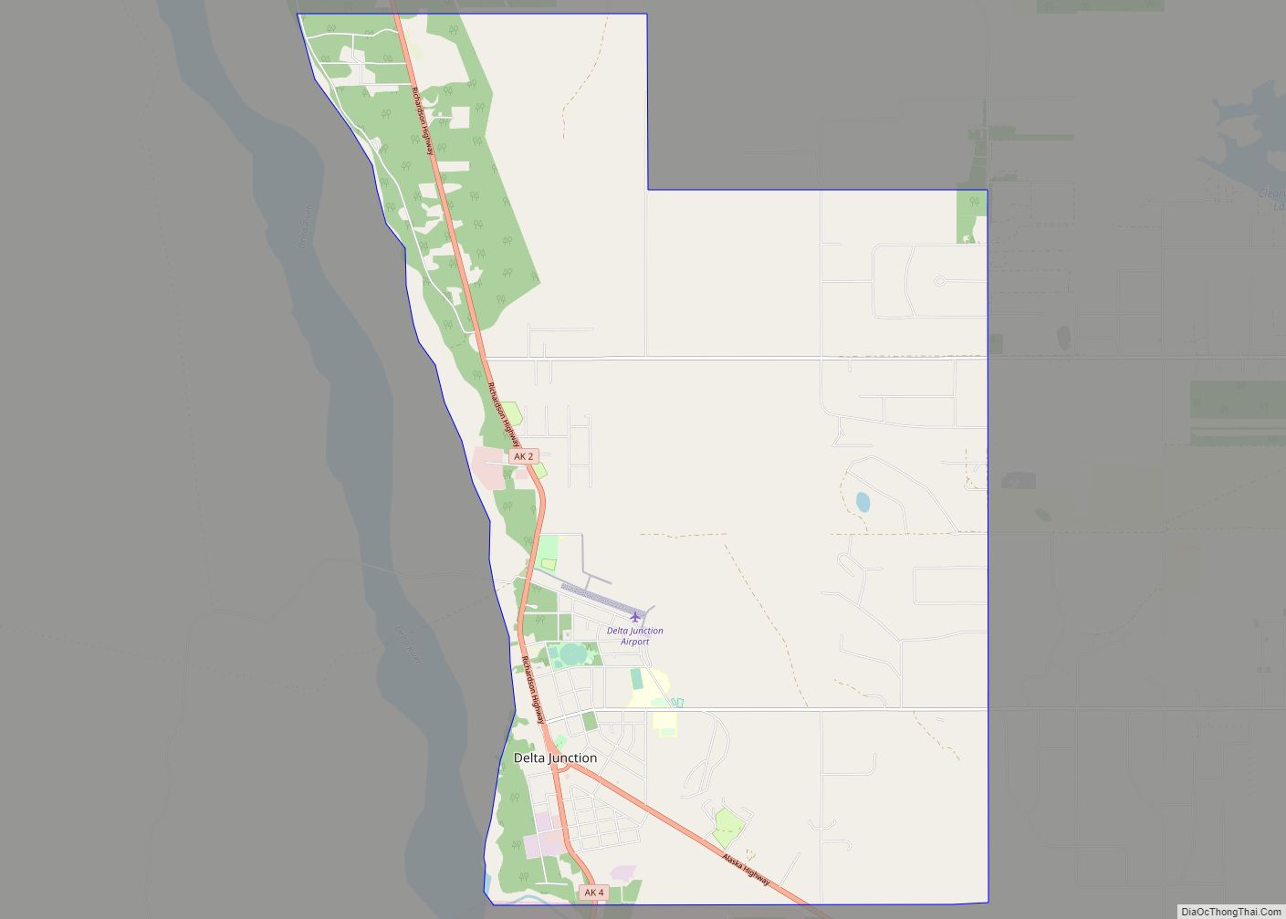
Delta Junction (Russian: Делта-Джанкшен; Ukrainian: Делта-Джанкшен, romanized: Delta Dzhankshen) is a city in the Southeast Fairbanks Census Area, Alaska, United States. As of the 2010 census, the population was 958, up from 840 in 2000. The 2018 estimate was down to 931. The city is located a short distance south of the confluence of the Delta River with the Tanana River, which is at Big Delta. It is about 160 km (99 mi) south of Fairbanks. Native inhabitants are Tanana Athabaskans.
| Name: | Delta Junction city |
|---|---|
| LSAD Code: | 25 |
| LSAD Description: | city (suffix) |
| State: | Alaska |
| County: | Southeast Fairbanks Census Area |
| Incorporated: | December 1960 |
| Elevation: | 1,158 ft (353 m) |
| Total Area: | 13.90 sq mi (36.00 km²) |
| Land Area: | 13.88 sq mi (35.95 km²) |
| Water Area: | 0.02 sq mi (0.05 km²) |
| Total Population: | 918 |
| Population Density: | 66.14/sq mi (25.54/km²) |
| ZIP code: | 99737 |
| Area code: | 907 |
| FIPS code: | 0218620 |
| GNISfeature ID: | 1401104 |
| Website: | ci.delta-junction.ak.us |
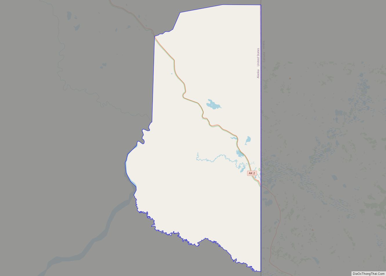
Online Interactive Map
Click on ![]() to view map in "full screen" mode.
to view map in "full screen" mode.
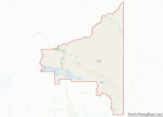
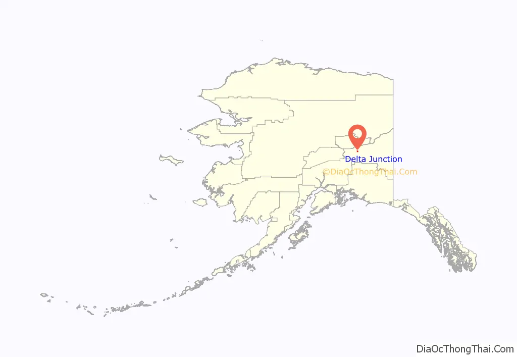
Delta Junction location map. Where is Delta Junction city?
History
For at least 10,000 years, Athabascan indigenous peoples have inhabited portions of the interior of Alaska. Early inhabitants survived by hunting and fishing.
The early history of non-native settlement in the area occurred at the river crossing at Big Delta and is found at the entry, Big Delta, Alaska. In 1904, the town first served as a telegraph station. In 1928, a herd of 23 bison were brought from the National Bison Range in Montana to an area south of Big Delta to provide an additional game species for hunters. Buffalo Center, a small community near the center of present-day Delta Junction, was named because of their presence, especially during the winter months. The huge animals were troublesome, and sometimes made landings dangerous at nearby Allen Army Airfield.
During World War II, the United States aided the Soviet Union against Germany by sending airplanes and supplies authorized by the Lend-lease Act to the Soviet Union through Alaska into the Russian Far East. The Alaska Highway was built to connect an existing road in Dawson Creek, British Columbia, Canada, with the Richardson Highway in Alaska, a distance of 2,290 km (1,420 mi).
The Alaska Highway met the Richardson Highway at a point 12 km (7.5 mi) south along the Delta River from Big Delta. The place where the highways met became known as Delta Junction. Allen Army Airfield was constructed 5 miles (8.0 km) south of Delta Junction for use in sending supplies to Russia. The Glenn Highway was built from Anchorage to what is now Glennallen, where it met the Richardson Highway. This connection created a motor route between Anchorage and Fairbanks, Alaska.
After World War II, a U.S. army base, Fort Greely, was built next to the air field. The base, and a huge tract of land around it, was used for training soldiers for cold weather combat during the Cold War with the former Soviet Union.
In 1957, the Richardson Highway was paved. About this time, portions of the Alaska Highway were also paved. The army base and tourism brought on the highways, caused a boom in the area’s economy and the commercial center of the area moved from Big Delta to Delta Junction. After World War II, some people also began farming and raising livestock in the Delta Junction area. This farming required new techniques to accommodate the short growing season and the cold and dark winters of interior Alaska.
Delta Junction was incorporated as a municipality in 1960. Oil was discovered in the North Slope of Alaska in 1968. In 1974, construction began on the pipeline to transport the oil from the North Slope to Valdez. The pipeline construction also aided the economy of the area. Delta Junction experienced a temporary boom, similar to the gold rush, that resulted in a wave of new residents and businesses in the community. Cost of living during this period was well above the national average due to transportation costs, as well as gouging. Prostitution and bars flourished — as did churches and religious communes.
In the late 1970s and early 1980s, the Tanana Valley was designated as a potential agricultural area for Alaska. The state of Alaska then made large tracts of land available to future farmers for purchase. Significant was establishment of the “Barley Project” east of the city. Plans were made to grow barley, ship it to Valdez via a future rail terminal, and from there ship it overseas to Asia. Though farms were established and a storage facility constructed in Valdez, the railroad never came, essentially resulting in the failure of the project. Political pressure and growing costs resulted in the project being defunded upon change in governors. Today, these original farms are primarily used as pasture or for hay production though barley, potatoes, carrots, and even wheat are still grown with limited commercial success. With the availability of a nearby meat processing facility (Delta Meat and Sausage Company), many farmers turned to cattle with limited success. In addition, the area is now known for production of exotic meats such as yak, bison, and elk.
In 1971, the George Parks Highway between Anchorage and Fairbanks was completed. This highway followed the railroad route and was a shorter route for motorists traveling between Anchorage and Fairbanks than the Glenn and Richardson Highway route. Many travelers used the new highway, bypassing Delta Junction. In 1977, pipeline construction ended. The Cold War also ended with the collapse of the Soviet Union in 1991. These events caused a decline in the economy of Delta Junction.
During the 1990s and 2000s, immigrants from the former Soviet republics came to the area, significantly changing the makeup of the local population.
Fort Greely was included on the Base Realignment and Closure (BRAC) list in 1995. From 1995 to 2002, Fort Greely was gradually re-aligned through a gradual drawdown in both military and civilian personnel. Once BRAC was complete in 2002, Fort Greely remained open but was staffed with less than 100 military and civilian personnel. During this time the remaining workers were either associated with public works functions or the Cold Regions Test Center, which continued testing on the installation. Headquarters for both the Cold Regions Test Center and the Northern Warfare Training Center moved to Fort Wainwright in Fairbanks in 2002. Base housing and numerous surplus buildings remained vacant, though the Army continued heating and maintaining them.
Re-alignment of Fort Greely resulted in heated discussion throughout the Delta Junction community over a proposal to site a privately operated state prison within surplus buildings on Fort Greely. Eventually, the city of Delta Junction entered into a contract with Allvest Corporation to operate this prison. Plans for the prison eventually fell through. Allvest Corporation subsequently sued Delta Junction for $1 million for breach of contract.
Shortly after BRAC was complete, the United States government announced plans to build a missile defense installation at Ft. Greely. The installation was then divided into two parts operated by two different commands — U.S. Army Garrison Alaska and Space and Missile Defense Command. The main post retained the name Fort Greely and is operated by the Space and Missile Defense Command. Outlying range, training and impact areas were absorbed by Fort Wainwright and were renamed Donnelly Training Area.
From 2002 to 2005, Delta Junction experienced an economic boom similar to the pipeline days as Fort Greely became fully operational again and the missile test bed was constructed. National firms such as Boeing, Bechtel, and Brown and Root, as well as regional firms including Chugach opened up offices on the installation, under contract to the government. Construction of the Pogo Gold Mine just north of Delta Junction, near the Goodpaster River, also contributed significantly to the economic fortune of the city. Mineral deposits near Tangle Lakes, south of Delta Junction, will likely result in additional development of mining in the area.
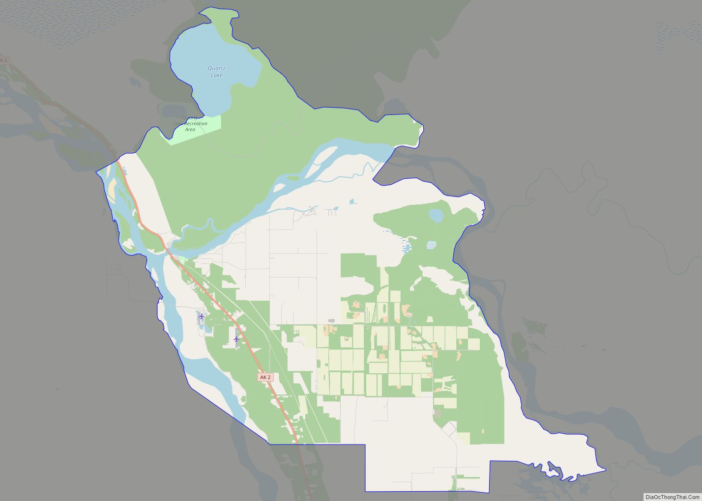
Delta Junction Road Map
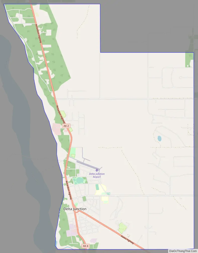
Delta Junction city Satellite Map

Geography
“Big Delta” lies at the intersection of the Delta River and the Tanana River. The city of Delta Junction sits on the Delta River at the intersection of the Richardson Highway and the terminus of the Alaska Highway. The city and Delta community lie within the fertile Tanana River valley. Three mountain ranges—the White Mountains to the north, the Granite Mountains to the southeast, and the Alaska Range to the southwest—and the Delta River to the west surround the city.
Once overlain by glaciers, the geology is marked by glacial moraines as well as alluvial deposits from the Delta and Tanana Rivers. Numerous mineral deposits are found in the vicinity of Delta Junction ranging from gold to molybdenum to coal. A prominent natural feature on the landscape is Donnelly Dome, located within the Donnelly Training Area of Fort Wainwright (formerly a part of nearby Fort Greely until 2001), to the south of Delta Junction. This dome was formed as a glacier coming from the Alaska Range split in two, carving away sides of a former mountain.
According to the United States Census Bureau, the city has a total area of 17.3 square miles (45 km), all land.
Climate
As is typical of the Alaska Interior, Delta Junction has a subarctic climate (Köppen Dwc). The average high temperature is below freezing from mid-October thru late March, and during the height of winter cold, as the town is located in USDA Plant Hardiness Zone 2a, the coldest conditions of the year typically bottom out in the −45 to −50 °F (−43 to −46 °C) range, with sub-0 °F (−18 °C) highs a common occurrence. Precipitation averages at only 11.62 inches (295 mm) annually, and over half of this total occurs from June to August. Snow, which typically falls from October to April and sometimes May and September, is generally not heavy due to the dry climate, and averages 54 inches (140 cm) per season. Extreme temperatures have ranged from −63 °F (−53 °C) on January 30, 1947 up to 92 °F (33 °C) on June 15, 1969. Delta Junction has an unofficial record low of -72 set on January 6, 1975 (as seen on the big thermometer in the town center) but the Delta Junction weather station and NOAA refuse to acknowledge this record as legitimate, as such temperatures are atypical for the region and atypical temperature readings are usually inaccurate.
The coldest daily maximum on record from Delta Junction was an extremely cold −55 °F (−48 °C) in January 1975. During an average year between 1991 and 2020, the coldest maximum averaged −39 °F (−39 °C). Summer nights are seldom warm but nevertheless did not fall below 70 °F (21 °C) in August 1999. During an average year the warmest low is 61 °F (16 °C).
Delta Junction was known as the “Windy City” and “Little Chicago” by many soldiers on Fort Greely. In Delta Junction itself, but not in the nearby areas, wind blows many days from the south down the Delta River from the Gulf of Alaska, bringing river silt in the summer and snowdrifts in the winter. There are usually several days in the winter when the temperature is in the range of −40 °F/°C when a wind (known as a Chinook wind) begins to blow. A few minutes later, the temperature climbs to above the freezing mark. When the wind stops, the temperature returns to colder ranges.
Delta Junction’s prevailing winds are from the east.
- ^ Mean monthly maxima and minima (i.e. the highest and lowest temperature readings during an entire month or year) calculated based on data at said location from 1991 to 2020.
See also
Map of Alaska State and its subdivision:- Aleutians East
- Aleutians West
- Anchorage
- Bethel
- Bristol Bay
- Denali
- Dillingham
- Fairbanks North Star
- Haines
- Juneau
- Kenai Peninsula
- Ketchikan Gateway
- Kodiak Island
- Lake and Peninsula
- Matanuska-Susitna
- Nome
- North Slope
- Northwest Arctic
- Prince of Wales-Outer Ketchi
- Sitka
- Skagway-Yakutat-Angoon
- Southeast Fairbanks
- Valdez-Cordova
- Wade Hampton
- Wrangell-Petersburg
- Yukon-Koyukuk
- Alabama
- Alaska
- Arizona
- Arkansas
- California
- Colorado
- Connecticut
- Delaware
- District of Columbia
- Florida
- Georgia
- Hawaii
- Idaho
- Illinois
- Indiana
- Iowa
- Kansas
- Kentucky
- Louisiana
- Maine
- Maryland
- Massachusetts
- Michigan
- Minnesota
- Mississippi
- Missouri
- Montana
- Nebraska
- Nevada
- New Hampshire
- New Jersey
- New Mexico
- New York
- North Carolina
- North Dakota
- Ohio
- Oklahoma
- Oregon
- Pennsylvania
- Rhode Island
- South Carolina
- South Dakota
- Tennessee
- Texas
- Utah
- Vermont
- Virginia
- Washington
- West Virginia
- Wisconsin
- Wyoming