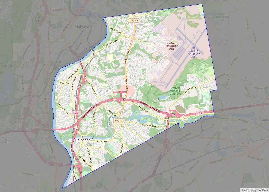
Chicopee (/ˈtʃɪkəpi/ CHIK-ə-pee) is a city located on the Connecticut River in Hampden County, Massachusetts, United States. At the 2020 census, the city had a population of 55,560, making it the second-largest city in Western Massachusetts after Springfield. Chicopee is part of the Springfield, Massachusetts Metropolitan Statistical Area. The communities of Chicopee Center (Cabotville), Chicopee Falls, Willimansett, Fairview, Aldenville, Burnett Road, Smith Highlands and Westover are located within the city.
One of the ventures of the Boston Associates, Chicopee is a city built around several smaller former mill communities on its namesake, the Chicopee River. During the 19th century, the city was home to the first American producer of friction matches as well as a variety of other industries, including the Ames Manufacturing Company, an early pioneer in machining lathes, building upon the work of Springfield’s Thomas Blanchard, and the largest producer of swords and cutlasses for the Union Army during the Civil War. By the start of the 20th century, the city was home to a number of industrial plants, including those of the Fisk Tire Company, one of the largest tire makers of that time, and some of the earliest sporting goods factories of A. G. Spalding.
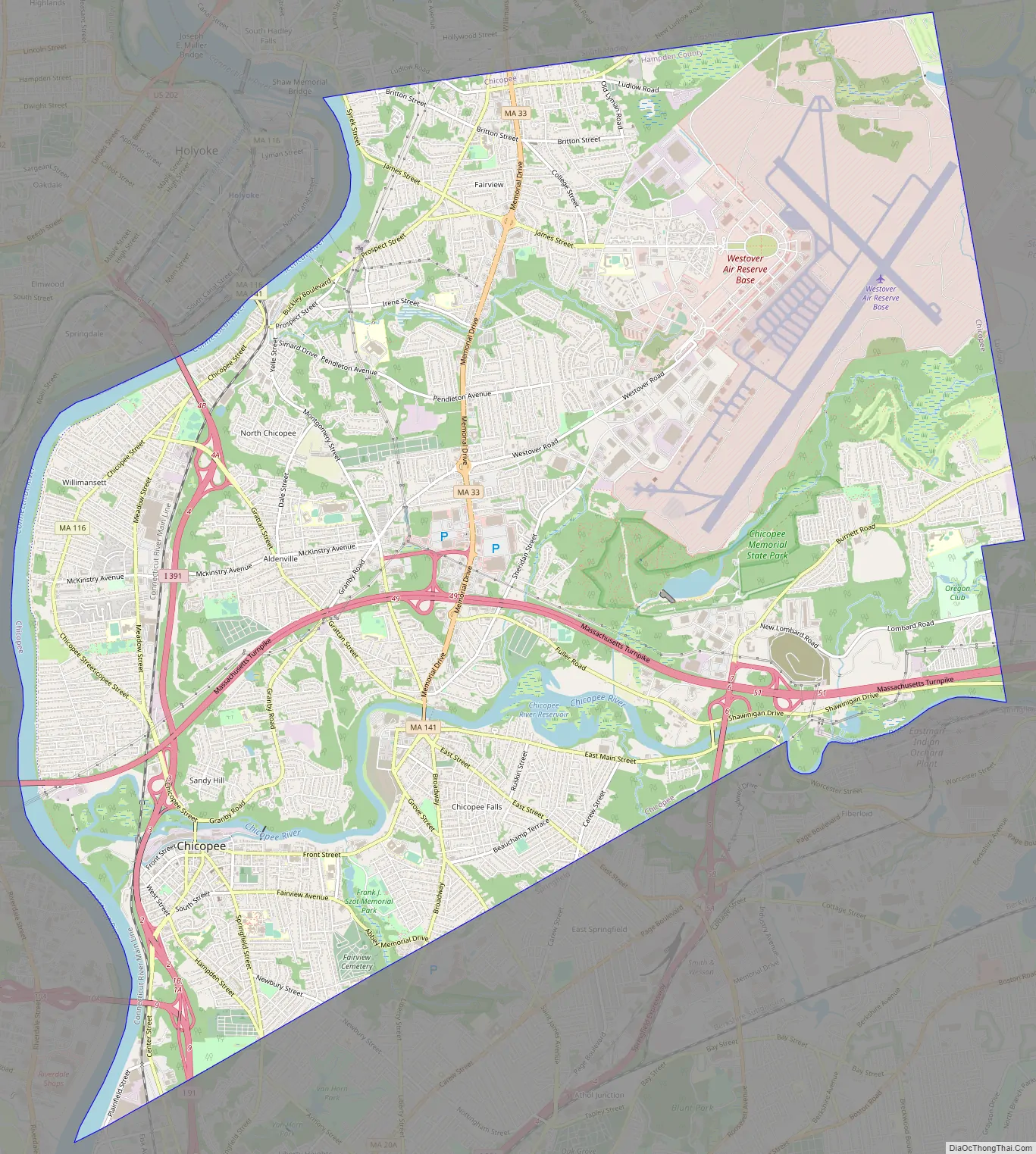
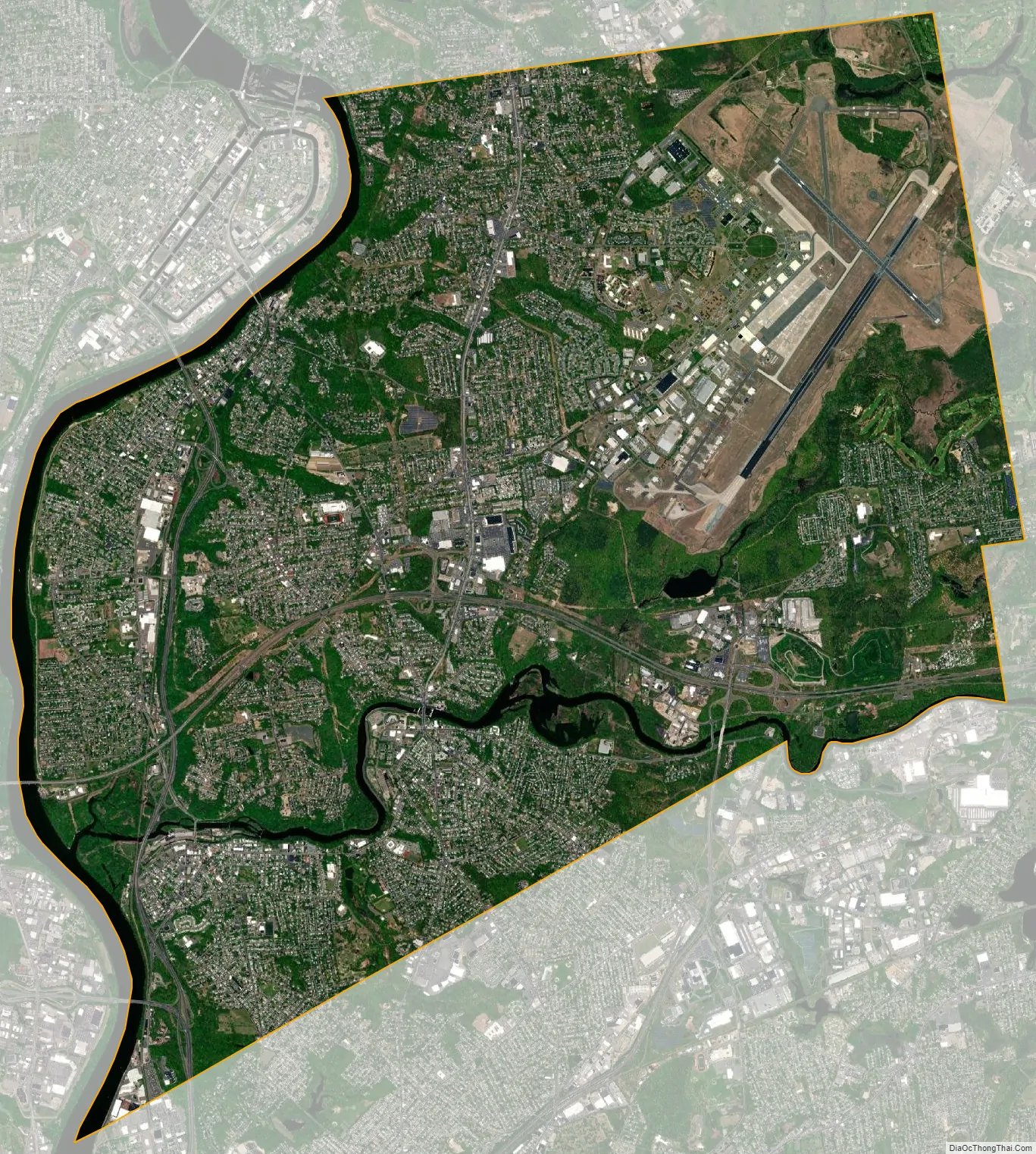
Today the city is home to a variety of specialty manufacturers, as well as Westover Air Reserve Base, the largest Air Force Reserve Base of the United States, built in 1940 with the emergence of World War II. Chicopee today goes by the nickname the “Crossroads of New England” as part of a business-development marketing campaign, one that West Springfield also uses. The name reflects the city’s location among a number of metropolitan areas and its transportation network. Four interstate highways run through its boundaries, including I-90, I-91, I-291, and I-391, as well as state routes such as Route 33, 116, and 141.
| Name: | Chicopee city |
|---|---|
| LSAD Code: | 25 |
| LSAD Description: | city (suffix) |
| State: | Massachusetts |
| County: | Hampden County |
| Elevation: | 200 ft (61 m) |
| Total Area: | 23.87 sq mi (61.83 km²) |
| Land Area: | 22.91 sq mi (59.33 km²) |
| Water Area: | 0.97 sq mi (2.50 km²) |
| Total Population: | 55,560 |
| Population Density: | 2,425.57/sq mi (936.53/km²) |
| Area code: | 413 |
| FIPS code: | 2513660 |
| GNISfeature ID: | 0617597 |
| Website: | www.chicopeema.gov |
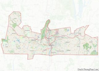
Online Interactive Map
Click on ![]() to view map in "full screen" mode.
to view map in "full screen" mode.
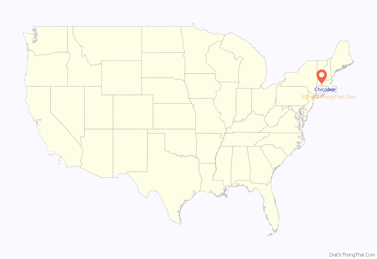
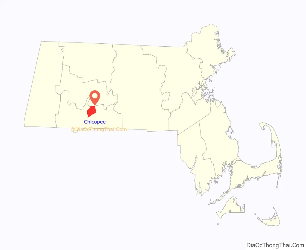
Chicopee location map. Where is Chicopee city?
History
Nayasett (Cabotville and Chicopee Falls)
In 1636, William Pynchon purchased land from the Agawam Indians on the east side of the Connecticut River. He moved from the Town of Roxbury to Springfield to found the first settlement in the area that comprises the territory of today’s Chicopee Center (Cabotville). Both Cabotville and the Falls were developed as manufacturing centers (villages).
According to local historian Charles J. Seaver, the area above the falls was first settled in 1660. The land purchased from the Indians was divided into districts. Nayasett (Nipmuc for “at the small point/angle”) was the name given to the area of what are now Chicopee Center and Chicopee Falls. The settlement in the upper district was at Skipmuck (possibly based on Nipmuc Skipmaug, meaning “chief fishing place” or Shipmuck, meaning “big watery place”), a place above the falls on the south side of the river.
Colonists built a sawmill as the first industrial site along the river. The mill was built at Skenungonuck (Nipmuc for “green fields”) Falls (now Chicopee Falls) in 1678 by Japhet Chapin, John Hitchcock and Nathaniel Foote.
In 1786, what was called Factory Village began to develop when two acres of land was leased to 10 local men, with the understanding that they would build an iron foundry within two years. This was accomplished and the business flourished.
In 1823, Jonathan Dwight purchased the water privilege at Skenungonuck Falls in Chicopee. He built a textile mill and five years later, it operated 14,000 spindles and nearly 500 looms, making it the second-largest operation in the state. It processed cotton from the Deep South, becoming part of the extended slave economy and King Cotton. By 1831, settlers had developed two giant dams, two waterpower canals, and two manufacturing communities on the Chicopee River.
In 1848, Chicopee, which for more than two centuries had been a part of the Town of Springfield, was separated and organized as a distinct town. Political factions in Springfield wanted that jurisdiction to remain a town, rather than become a city and take on a mayoral form of government. By partitioning Chicopee, those political factions prevented Springfield from becoming a city until 1852. The result was that Springfield lost 2/5 of its land area and nearly half of its population when Chicopee was created.
Before and after the partition, eight Chicopee River companies gained product recognition around the globe: Ames, Belcher, Lamb, Dwight, Stevens, Spalding, Fisk, and Duryea. Below the falls, in the bend of the river at a place called Factory Village, an important chapter of the region’s industrial history was played out.
Partition from Springfield
The villages of Cabotville, Chicopee Falls, Willimansett, and Fairview (and the lands that would become Aldenville) remained a part of Springfield, Massachusetts, from 1636 until 1848, when they were partitioned to form the Town of Chicopee. Political factions in Springfield had wished to keep Springfield a town, instead of becoming a city, which would give it a mayoral form of government. To keep Springfield sufficiently unpopulated to avoid a state regulation that would have required it to become a city, they created Chicopee, which contained approximately two-fifths of Springfield’s land area and nearly half of its population. Despite the partition, Springfield became a city only four years later. The Town of Chicopee incorporated on April 29, 1848.
Incorporation as a City
On April 18, 1890, the community was granted a charter as a city by the Massachusetts General Court. George Sylvester Taylor (1822–1910) became Chicopee’s first mayor on January 5, 1891.
Westover Field was created by a war-readiness appropriation signed by president Franklin D. Roosevelt in 1939. The site used to be tobacco crop fields east of and part of Fairview, east of Aldenview, and northern Willimansett. It was assigned to the United States Army Air Corps Northeast Air District. It was renamed Westover Air Force Base in 1948 after that Air Force’s creation as a separate service. In 1974 SAC leadership turned the base over to the Air Force Reserve.
In 1991, St. Stanislaus Bishop and Martyr Church, located on Front Street, was proclaimed a minor basilica by Pope John Paul II.
Various industries
Chicopee adopted the motto “Industriae Variae”, which means “Various Industries”. Chicopee’s industries included cotton mills, woolen mills, textiles, brass and iron foundries, paper making, footwear factories, for leather boots and shoes, the first friction matches, and ship building. In nearby South Hadley Canal, the firearms company Crescent-Davis specialized in producing double-barrel shotguns.
The Ames Manufacturing Company made many machines and bronze cannons, and more swords than any other American manufacturer at the time. Ames cast a number of bronze statues, including Thomas Ball’s monumental equestrian statue of President George Washington, installed in Boston’s Public Garden. Ames was a major provider of cannon to the Union army during the Civil War. The Stevens Arms plant (later Savage) was responsible for most of the No. 4 Enfields manufactured for the British under Lend-Lease. Chicopee was home to production of the first gasoline-powered automobile made in the United States, the Duryea.
During the late nineteenth century, Chicopee Falls became a major manufacturing center of bicycles. The town was the site of at least two bicycle factories: The Overman Wheel Company (1882 to about 1899), and the Spalding sporting goods company.
Albert H. Overman moved his bicycle production from Hartford, Connecticut, to Chicopee Falls in 1883. The Overman company benefited from the surging popularity of the safety bicycle during the bicycle boom of the 1890s. At its height in 1894, Overman’s factory employed over 1,200 workers. The boom eventually went bust, as overproduction drove the price of bicycles down. By 1901 the Overman firm was out of business.
Library
Chicopee was the first Massachusetts municipality west of Worcester County to form a publicly funded public library. The Chicopee Public Library was formed by a donation to the city by the Cabotville Institute.
Chicopee Road Map
Chicopee city Satellite Map
Geography
Chicopee is located at 42°10′13″N 72°35′19″W / 42.17028°N 72.58861°W / 42.17028; -72.58861 (42.170159, –72.588630).
The city is made up of several neighborhoods; the result of the city’s origin as a collection of four villages in the northernmost part of Springfield, which seceded from it in 1848. Chicopee Falls, Chicopee Center (Cabotville), Fairview, and Willimansett continued to develop. In the early 1900s, Aldenville developed as a distinct community. Since then, the city has filled in most of its open space resulting in a number of new neighborhoods. These neighborhoods include Chicomansett, Ferry Lane, Sandy Hill and the geographically isolated Burnett Road neighborhood.
The city is bordered by Holyoke to the northwest, West Springfield to the southwest, Springfield to the south, Ludlow to the east, Granby to the northeast and South Hadley to the north. Chicopee is located 29 miles (47 km) away from Hartford, 89 miles (143 km) away from Boston, 90 miles (140 km) from Albany and 140 miles (230 km) from New York City.
According to the United States Census Bureau, the city has a total area of 23.9 square miles (62 km), of which 22.9 square miles (59 km) is land and 1.0 square mile (2.6 km) (4.31%) is water. The Chicopee River flows through the south part of the city, emptying into the Connecticut River. Many ponds, lakes, and streams are part of the Chicopee River or Connecticut River watersheds.
Willimansett, and portions of the Center and Falls are on low land, with Aldenville, Fairview, Westover, and the Burnett Road neighborhoods on an elevated plateau. At 288 feet, the highest elevation in the city is on Old Lyman Road, in the Fairview section.
See also
Map of Massachusetts State and its subdivision: Map of other states:- Alabama
- Alaska
- Arizona
- Arkansas
- California
- Colorado
- Connecticut
- Delaware
- District of Columbia
- Florida
- Georgia
- Hawaii
- Idaho
- Illinois
- Indiana
- Iowa
- Kansas
- Kentucky
- Louisiana
- Maine
- Maryland
- Massachusetts
- Michigan
- Minnesota
- Mississippi
- Missouri
- Montana
- Nebraska
- Nevada
- New Hampshire
- New Jersey
- New Mexico
- New York
- North Carolina
- North Dakota
- Ohio
- Oklahoma
- Oregon
- Pennsylvania
- Rhode Island
- South Carolina
- South Dakota
- Tennessee
- Texas
- Utah
- Vermont
- Virginia
- Washington
- West Virginia
- Wisconsin
- Wyoming