Bloomingdale is a borough in Passaic County, in the U.S. state of New Jersey. As of the 2020 United States census, the borough’s population was 7,777, an increase of 121 (+1.6%) from the 2010 census count of 7,656, which in turn reflected an increase of 46 (+0.6%) from the 7,610 counted in the 2000 census.
| Name: | Bloomingdale borough |
|---|---|
| LSAD Code: | 21 |
| LSAD Description: | borough (suffix) |
| State: | New Jersey |
| County: | Passaic County |
| Incorporated: | February 23, 1918 |
| Elevation: | 548 ft (167 m) |
| Total Area: | 9.25 sq mi (23.95 km²) |
| Land Area: | 8.80 sq mi (22.79 km²) |
| Water Area: | 0.45 sq mi (1.16 km²) 4.82% |
| Total Population: | 7,777 |
| Population Density: | 883.6/sq mi (341.2/km²) |
| ZIP code: | 07403 |
| Area code: | 973 |
| FIPS code: | 3406340 |
| GNISfeature ID: | 0885161 |
| Website: | www.bloomingdalenj.net |
Online Interactive Map
Click on ![]() to view map in "full screen" mode.
to view map in "full screen" mode.
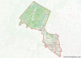
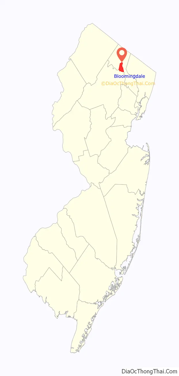
Bloomingdale location map. Where is Bloomingdale borough?

History
Bloomingdale’s Federal Hill was the site of the 1781 Pompton Mutiny, a winter revolt of Continental Army troops that was crushed by General Robert Howe on direct orders of General George Washington.
Growth in Bloomingdale was driven by the development in the late 1860s of a rubber mill and other factories in neighboring Butler. The New Jersey Midland Railroad, later known as the New York, Susquehanna and Western Railway, laid tracks adjacent to the settlement, with a Bloomingdale station located in what today is Riverdale. The northern section of Riverdale and most of Butler were known as East Bloomingdale and West Bloomingdale respectively during most of the 19th century. Despite crossing a county border, they also shared a school district and residents considered the whole area as “Bloomingdale” until about 1881 when a Post Office named Butler was designated. This began a period of rivalry which caused a schism between the residents of Butler and Bloomingdale resulting in separate schools, churches and even town bands.
Bloomingdale was incorporated as an independent borough on February 23, 1918, when Pompton Township was split up into three new municipalities along with Wanaque and Ringwood. Prior to that, the area was known as Bloomingdale throughout the 19th century and was initially a farming community starting about 1712 with the “Bloomingdale Forge” built shortly thereafter to take advantage of the iron in the hills. The business district along the Paterson-Hamburg Turnpike and the Pequannock River began about the middle of the 19th century.
Bloomingdale, like most municipalities in northeastern North Jersey, is a suburb of New York City. Some of the things that still link Bloomingdale to its past are its two churches (Methodist and Baptist), the Samuel R. Donald School (originally built in 1886) and the Bloomingdale Cornet Band continuously active since 1884.
DeLazier Field, used by the Triboro Little League, was the home field for the Minor League Baseball team known as the Bloomingdale Troopers of the North Atlantic League from 1946 to 1948.
The History of Bloomingdale can be found in three separate books published by the borough in 1958, 1968 and 1993. Additionally, more history can be found in microfilmed local newspapers located at the Butler Museum, the Morristown Library, the Paterson Library and the New Jersey State Archives.
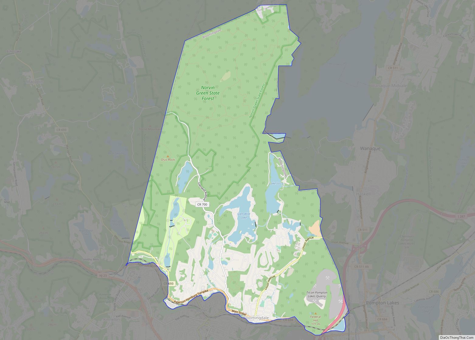
Bloomingdale Road Map
Bloomingdale city Satellite Map

Geography
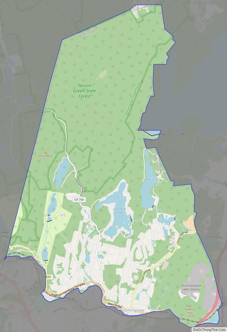
According to the United States Census Bureau, the borough had a total area of 9.25 square miles (23.95 km), including 8.80 square miles (22.79 km) of land and 0.45 square miles (1.16 km) of water (4.82%).
Lake communities in the borough include Glen Wild Lake, Lake Iosco, Kampfe Lake and Lower / Upper Morse Lake.
Unincorporated communities, localities and place names located partially or completely within the borough include Cold Spring Lake, Glenwild Lake, Iosco Lake, Lake Kampfe, Morse Lakes, Mothers Lake, Norvin Green State Forest, Pompton Junction, Star Lake and Twilliger Lake.
The borough borders Pompton Lakes, Ringwood, Wanaque and West Milford Township in Passaic County and both Butler and Riverdale in Morris County.
See also
Map of New Jersey State and its subdivision: Map of other states:- Alabama
- Alaska
- Arizona
- Arkansas
- California
- Colorado
- Connecticut
- Delaware
- District of Columbia
- Florida
- Georgia
- Hawaii
- Idaho
- Illinois
- Indiana
- Iowa
- Kansas
- Kentucky
- Louisiana
- Maine
- Maryland
- Massachusetts
- Michigan
- Minnesota
- Mississippi
- Missouri
- Montana
- Nebraska
- Nevada
- New Hampshire
- New Jersey
- New Mexico
- New York
- North Carolina
- North Dakota
- Ohio
- Oklahoma
- Oregon
- Pennsylvania
- Rhode Island
- South Carolina
- South Dakota
- Tennessee
- Texas
- Utah
- Vermont
- Virginia
- Washington
- West Virginia
- Wisconsin
- Wyoming