Edgewater is a borough located along the Hudson River in Bergen County, in the U.S. state of New Jersey. As of the 2020 United States census, the borough’s population was 14,336, an increase of 2,823 (+24.5%) from the 2010 census count of 11,513, which in turn reflected an increase of 3,836 (+50.0%) from the 7,677 counted in the 2000 Census
The borough’s history has featured the founding of the first colony in Bergen County, contribution to the Revolutionary War, a period as a “sleepy, pastoral little town” with resort hotels in the 19th century, industrialization in the early 20th century, and a transition to a rapidly growing residential community in the late 20th century.
Edgewater was incorporated as a municipality on December 7, 1894, from portions of Ridgefield Township as the Borough of Undercliff, based on the results of a referendum that passed two days earlier. The borough was formed during the “Boroughitis” phenomenon then sweeping through Bergen County, in which 26 boroughs were formed in the county in 1894 alone. The borough’s name was changed to Edgewater on November 8, 1899. The borough was named for its location on the Hudson River.
| Name: | Edgewater borough |
|---|---|
| LSAD Code: | 21 |
| LSAD Description: | borough (suffix) |
| State: | New Jersey |
| County: | Bergen County |
| Incorporated: | December 7, 1894, as Undercliff |
| Elevation: | 3 ft (0.9 m) |
| Total Area: | 2.43 sq mi (6.29 km²) |
| Land Area: | 0.97 sq mi (2.52 km²) |
| Water Area: | 1.46 sq mi (3.78 km²) 60.33% |
| Total Population: | 14,336 |
| Population Density: | 14,764.2/sq mi (5,700.5/km²) |
| ZIP code: | 07020 |
| Area code: | 201 |
| FIPS code: | 3420020 |
| GNISfeature ID: | 0885203 |
| Website: | www.edgewaternj.org |
Online Interactive Map
Click on ![]() to view map in "full screen" mode.
to view map in "full screen" mode.
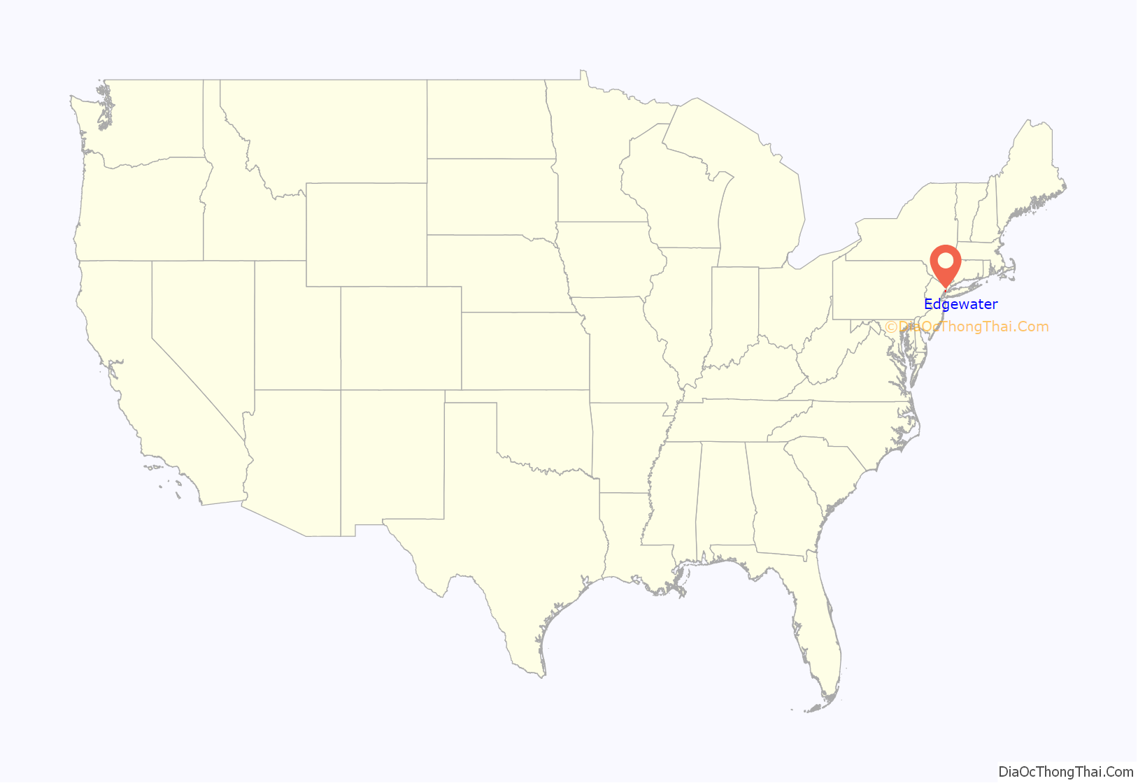
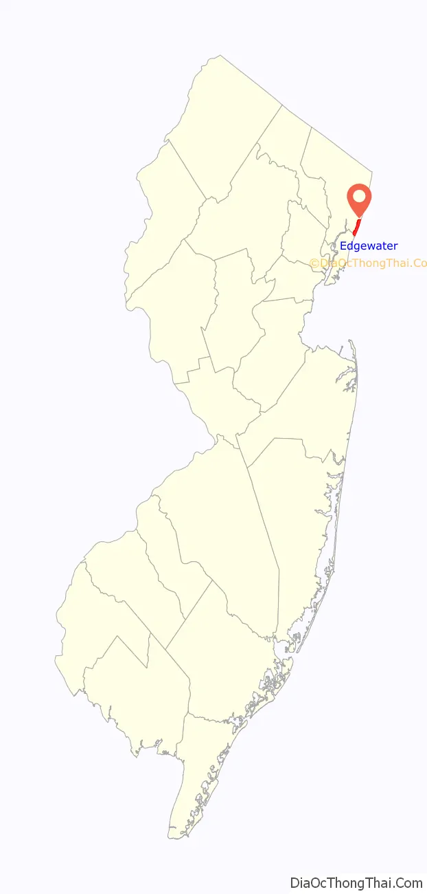
Edgewater location map. Where is Edgewater borough?
History
Native American people are known to have lived in the vicinity before the arrival of colonists in the 17th century. The Lenape were a local tribe of Native Americans associated with the neighboring borough of Fort Lee. David Pietersz Devries (also transliterated as David Pietersen de Vries), the first European settler, bought 500 acres (202 ha) of land from the Tappan tribe and established the settlement of Vriessendael in what is now Edgewater. A historical plaque placed in Veteran’s Field by the Bergen County Historical Society names Vriessendael as the first known colony in Bergen County with a founding date of 1640. Vriessendael was destroyed in 1643 in Kieft’s War by Indians reacting to foolish actions by the director general of the Dutch West India Company, who lived across the river in New Amsterdam, as Manhattan was then known. In pioneer days, River Road was known as the Hackensack Turnpike, and Ox [sic] Hill Road was an important route to the top of the Palisades Cliff. While Oxen Hill Road still exists as a thoroughfare, another Colonial hallmark and major local industry has only recently disappeared: shad fishing. The Undercliff section in the northern section of Edgewater was originally a colony of fishermen. In the 1980s there were still about 100 commercial fishermen in New Jersey harvesting shad from their annual spring run from the Atlantic Ocean up the Hudson River to spawn. Now there are none.
Etienne Burdett began ferry service between north Edgewater and the island of Manhattan in 1758. His gambrel-roofed house in what is now the Edgewater Colony stood until 1899. The ferry service at Burdett’s Landing, which was located at the southern base of the bluff of Fort Lee, proved valuable to the American cause during the Revolutionary War. The ferry functioned as the link for supplies, information and transportation between Fort Lee on the New Jersey side of the Hudson River and Fort Washington on the New York side. In the century following the Revolutionary war, north Edgewater developed into a resort area with large hotels built in the mid- and late 19th century. It was in the 19th century that Burdett’s Landing became known as “Old Stone Dock”, as cobblestones quarried from the Palisades Cliffs by Russell & Read were shipped across the Hudson to fill the demand for paving Manhattan streets. Concern over the destruction caused by quarrying operations led to the formation of the Palisades Interstate Park in 1900, which was effective in preserving the cliffs. Although the first chemical plant was founded in 1843 in the south section of the borough, throughout the 19th century the town retained a bucolic character. Early in the 20th century the addition of landfill to the Hudson River changed the borough’s appearance. Until that time, the Hudson River lay closer to River Road from just above Veteran’s field southward to what is now the Binghamton Ferry Plaza.
The 20th century brought great change to Edgewater with industrialization, which overwhelmed the borough and filled 3 miles (4.8 km) of the shoreline with its operations. Transportation of factory goods was facilitated when the New York, Susquehanna and Western Railway cut the Edgewater Tunnel through the Palisades in 1894 to connect the borough to its main line. Edgewater was also well situated for shipping, with deep water piers on the Hudson River and access to abundant labor from Manhattan. Generally, industrial development occurred in the southern end of the borough, while the northern end remained residential. As industrialization increased in the borough, picnic grounds lost their appeal and resort hotels faded. By 1918, there were 8,044 workers employed by Edgewater’s manufacturing facilities, producing primarily chemicals, dyes, and confectionery products such as oils and sugars. Prominent industries of Edgewater included a Ford assembly plant, Alcoa, Valvoline, and the American Can Company. Railroad trains served various factories, traversing tracks laid in River Road. During the first 30 years of the century, Edgewater’s population quadrupled, and the transient workforce increased tenfold. Eventually the factories closed. The reasons were varied, but they included the globalization of industry, obsolete facilities and the replacement of railroad shipping by trucking, which could not run its large tractor trailer trucks on Edgewater’s narrow streets.
Joseph Mitchell’s essay The Rivermen, which was published in The New Yorker and is included in his book The Bottom of the Harbor, provides an evocative portrait of life in Edgewater in the early 20th century.
The late 20th century history of Edgewater was one of change from an industrialized town to a residential one. With the closing of the factories, development initially came to Edgewater in the 1960s and grew exponentially in the early 1980s, as developers began projects to convert the industrial sites that had historically led to Edgewater not being considered as an option for development. As condominiums were built along the Hudson where industry had formerly operated, the population of Edgewater grew rapidly. The population had been mostly in the 4,000 to 5,000 range from 1930 to 1990, then increased by 50% to 7,677 in 2000 and again by 50% to 11,513 in the 2010 Census. Borough council members and residents acknowledge that population growth has exacerbated the problem of increased traffic. With the transition from industrial to residential, crime statistics were down, with the police chief describing how bar fights between factory workers were commonplace in the early 1970s, while real estate values are up. Because of the expense of buying property, some currently refer to Edgewater as part of the Gold Coast. A photographic history of Edgewater describes the population and demographics change and its possible consequence this way:
Although the borough is unrecognizable as the industrial town it once was, growing pains have left marks. When the old Alcoa plant site from 1916 began to be converted to condominiums, construction was forced to halt for cleanup of industrial contaminants, including excessively high concentrations of PCBs. In another case, construction of a condominium/shopping center in south Edgewater was interrupted for six months by safety measures to protect workers from chemical exposure in the lead- and arsenic-riddled soil. Next to this structure, behind a chain link fence lies a Superfund site. Operational Hess Oil tanks, beside the derelict Alcoa rolling mill, once the second-largest in the world, are a reminder of the borough’s industrial phase. The building, occupying 1,100,000 square feet (100,000 m2) of space, was designed in 1914 and was used to roll ingots of aluminum into sheets that were used to create everything from toothpaste tubes to aircraft frames, before the facility was abandoned in 1967 due to lack of space needed to expand the facility.
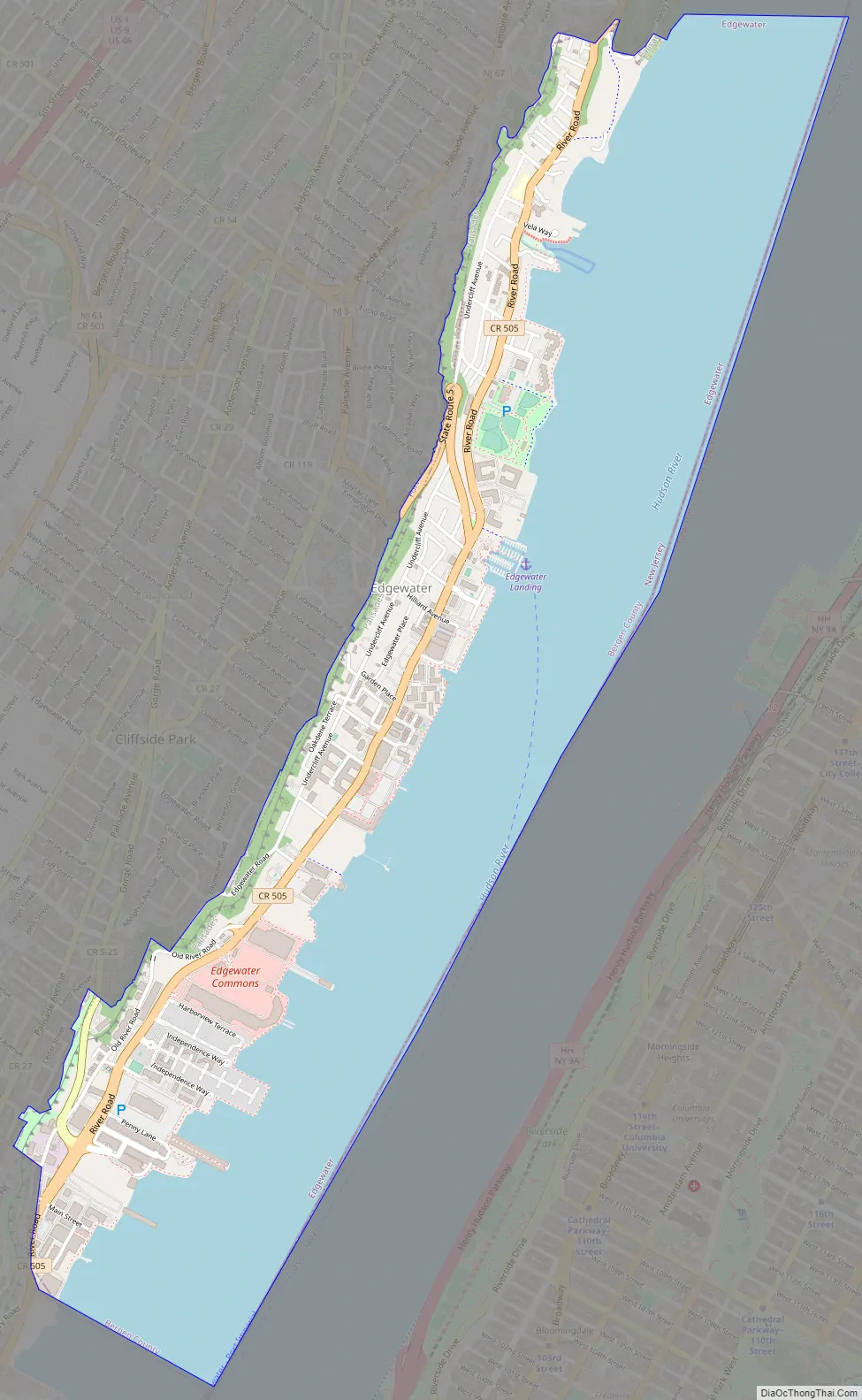
Edgewater Road Map
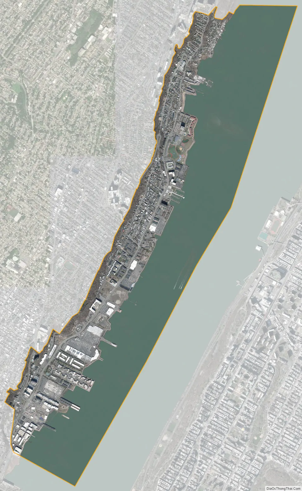
Edgewater city Satellite Map
Geography
According to the United States Census Bureau, the borough had a total area of 2.46 square miles (6.36 km), including 0.97 square miles (2.52 km) of land and 1.48 square miles (3.84 km) of water (60.33%).
The borough is a narrow strip of land along the Hudson River, with 3.5 miles (5.6 km) of waterfront. The Palisades Cliff rises dramatically and forms a natural border on its western side, running roughly parallel to the Hudson, with Fort Lee and Cliffside Park atop the cliff, north and south, respectively. Edgewater abuts Fort Lee Historic Park in the borough of Fort Lee on the north.
River Road, which overlooks the Hudson River and the Manhattan skyline, runs into and out of the town from the north and south, lying just above the level of the Hudson. Three roads lead up the Palisades Cliff: Route 5, with one switchback, ascends to Palisades Avenue, which leads north into Fort Lee and south into Cliffside Park. Gorge Road and Edgewater Road, the latter still referred to by many local residents by its Colonial-era name as Oxen Hill Road, lead up the Palisades to Cliffside Park.
The borough borders Cliffside Park and Fort Lee in Bergen County; North Bergen in Hudson County; and the New York City borough of Manhattan across the Hudson River.
See also
Map of New Jersey State and its subdivision: Map of other states:- Alabama
- Alaska
- Arizona
- Arkansas
- California
- Colorado
- Connecticut
- Delaware
- District of Columbia
- Florida
- Georgia
- Hawaii
- Idaho
- Illinois
- Indiana
- Iowa
- Kansas
- Kentucky
- Louisiana
- Maine
- Maryland
- Massachusetts
- Michigan
- Minnesota
- Mississippi
- Missouri
- Montana
- Nebraska
- Nevada
- New Hampshire
- New Jersey
- New Mexico
- New York
- North Carolina
- North Dakota
- Ohio
- Oklahoma
- Oregon
- Pennsylvania
- Rhode Island
- South Carolina
- South Dakota
- Tennessee
- Texas
- Utah
- Vermont
- Virginia
- Washington
- West Virginia
- Wisconsin
- Wyoming


