| Name: | Hoboken city |
|---|---|
| LSAD Code: | 25 |
| LSAD Description: | city (suffix) |
| State: | New Jersey |
| County: | Hudson County |
| Incorporated: | April 9, 1849 |
| Elevation: | 23 ft (7 m) |
| Total Area: | 1.97 sq mi (5.10 km²) |
| Land Area: | 1.25 sq mi (3.24 km²) |
| Water Area: | 0.72 sq mi (1.87 km²) 37.50% |
| Total Population: | 60,419 |
| Population Density: | 48,335.2/sq mi (18,662.3/km²) |
| ZIP code: | 07030 |
| Area code: | 201 |
| FIPS code: | 3432250 |
| GNISfeature ID: | 0885257 |
| Website: | hobokennj.gov |
Online Interactive Map
Click on ![]() to view map in "full screen" mode.
to view map in "full screen" mode.
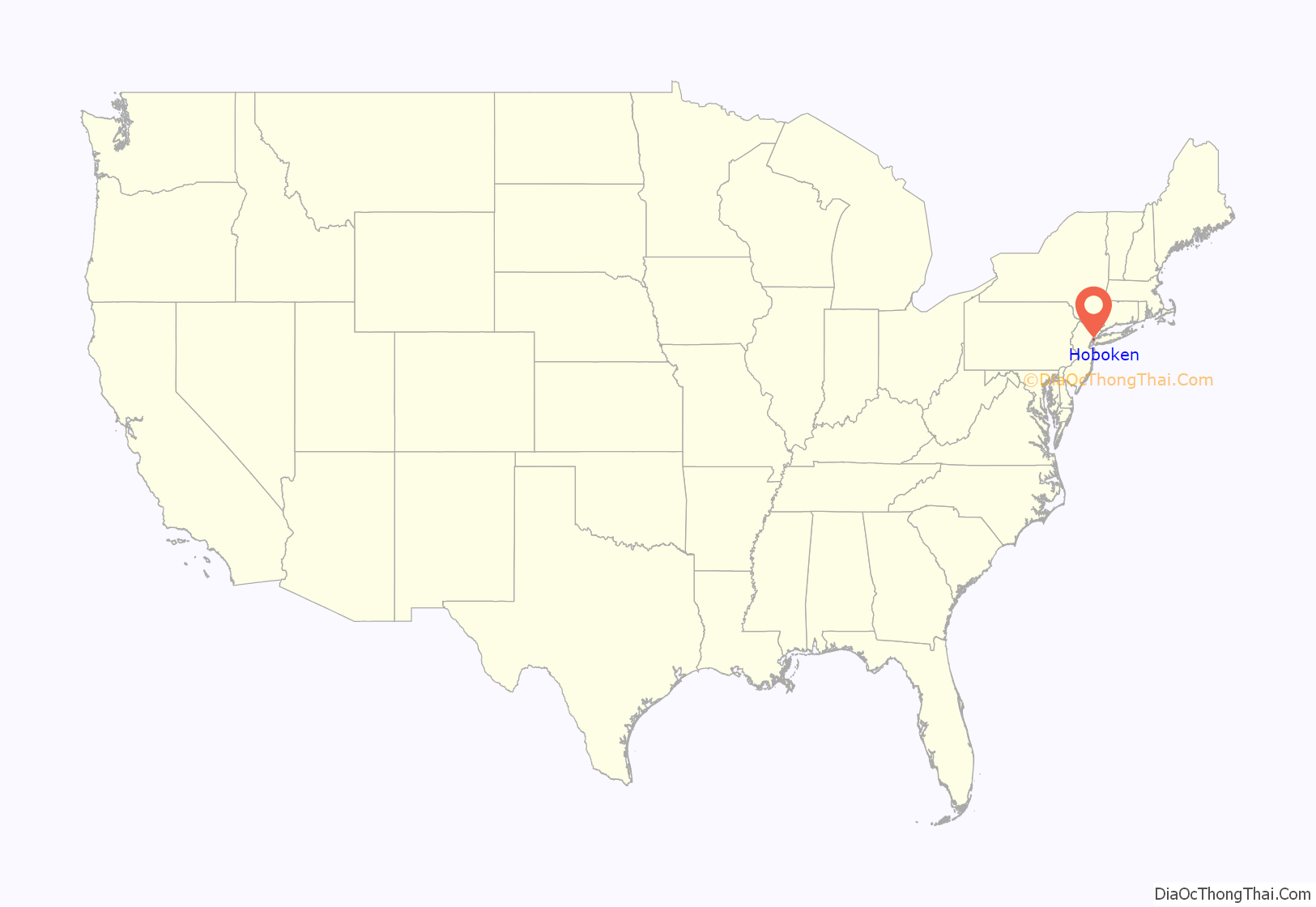
Hoboken location map. Where is Hoboken city?
History
Etymology
The name Hoboken was chosen by Colonel John Stevens when he bought land, on a part of which the city still sits. The Lenape, later called Delaware Indian tribe of Native Americans, referred to the area as the “land of the tobacco pipe”, most likely to refer to the soapstone collected there to carve tobacco pipes, and used a phrase that became “Hopoghan Hackingh”. Like Weehawken, its neighbor to the north, Communipaw and Harsimus to the south, Hoboken had many variations in the folks-tongue. Hoebuck, old Dutch for high bluff and likely referring to Castle Point, the district of the city highest above sea level, was used during the colonial era and later spelled as Hobuck, Hobock, Hobuk and Hoboocken. However, in the nineteenth century, the name was changed to Hoboken, influenced by Flemish Dutch immigrants and a folk etymology had emerged linking the town of Hoboken to the similarly-named Hoboken district of Antwerp.
Hoboken has been nicknamed the Mile Square City, but it actually occupies about 1.25 sq mi (3.2 km) of land. During the late 19th/early 20th century the population and culture of Hoboken was dominated by German language speakers who sometimes called it “Little Bremen”, many of whom are buried in Hoboken Cemetery, North Bergen.
Early-European arrival and colonial period
Hoboken was originally an island which was surrounded by the Hudson River on the east and tidal lands at the foot of the New Jersey Palisades on the west. It was a seasonal campsite in the territory of the Hackensack, a phratry of the Lenni Lenape, who used the serpentine rock found there to carve pipes.
The first recorded European to lay claim to the area was Henry Hudson, an Englishman sailing for the Dutch East India Company, who anchored his ship the Halve Maen (Half Moon) at Weehawken Cove on October 2, 1609. Soon after it became part of the province of New Netherland.
In 1630, Michael Reyniersz Pauw, a burgemeester (mayor) of Amsterdam and a director of the Dutch West India Company, received a land grant as patroon on the condition that he would plant a colony of not fewer than fifty persons within four years on the west bank of what had been named the North River. Three Lenape sold the land that became Hoboken and part of Jersey City for 80 fathoms (146 m) of wampum, 20 fathoms (37 m) of cloth, 12 kettles, six guns, two blankets, one double kettle, and half a barrel of beer. These transactions, variously dated as July 12, 1630 and November 22, 1630, represent the earliest known conveyance for the area. Pauw, whose Latinized name is Pavonia, failed to settle the land, and he was obliged to sell his holdings back to the company in 1633.
It was later acquired by Hendrick Van Vorst, who leased part of the land to Aert Van Putten, a farmer. In 1643, north of what would be later known as Castle Point, Van Putten built a house and a brewery, North America’s first. In series of Indian and Dutch raids and reprisals, Van Putten was killed and his buildings destroyed, and all residents of Pavonia, as the colony was then known, were ordered back to New Amsterdam. Deteriorating relations with the Lenape, its isolation as an island, or relatively long distance from New Amsterdam may have discouraged more settlement.
In 1664, the English took possession of New Amsterdam with little to no resistance, and in 1668 they confirmed a previous land patent by Nicolas Verlett. In 1674–1675, the area became part of East Jersey, and the province was divided into four administrative districts, Hoboken becoming part of Bergen County, where it remained until the creation of Hudson County on February 22, 1840. English-speaking settlers (some relocating from New England) interspersed with the Dutch, but it remained sparsely populated and agrarian.
Eventually, the land came into the possession of William Bayard, who originally supported the revolutionary cause, but became a Loyalist Tory after the fall of New York in 1776 when the city and surrounding areas, including the west bank of the renamed Hudson River, were occupied by the British. At the end of the Revolutionary War, Bayard’s property was confiscated by the Revolutionary Government of New Jersey. In 1784, the land described as “William Bayard’s farm at Hoebuck” was bought at auction by Colonel John Stevens for £18,360 (then $90,000).
19th century
In the early 19th century, Colonel John Stevens developed the waterfront as a resort for Manhattanites. On October 11, 1811, Stevens’ ship the Juliana, began to operate as a ferry between Manhattan and Hoboken, making it the world’s first commercial steam ferry. In 1825, he designed and built a steam locomotive capable of hauling several passenger cars at his estate. Sybil’s Cave, a cave with a natural spring, was opened in 1832 and visitors came to pay a penny for a glass of water from the cave which was said to have medicinal powers. In 1841, the cave became a legend, when Edgar Allan Poe wrote “The Mystery of Marie Roget” about an event that took place there. The cave was closed in the late 1880s after the water was found to be contaminated, and it was shut and in the 1930s and filled with concrete, before it was reopened in 2008. Before his death in 1838, Stevens founded the Hoboken Land and Improvement Company, which laid out a regular system of streets, blocks and lots, constructed housing, and developed manufacturing sites. In general, the housing consisted of masonry row houses of three to five stories, some of which survive to the present day, as does the street grid.
Hoboken was originally formed as a township on April 9, 1849, from portions of North Bergen Township. As the town grew in population and employment, many of Hoboken’s residents saw a need to incorporate as a full-fledged city, and in a referendum held on March 29, 1855, ratified an Act of the New Jersey Legislature signed the previous day, and the City of Hoboken was born. In the subsequent election, Cornelius V. Clickener became Hoboken’s first mayor. On March 15, 1859, the Township of Weehawken was created from portions of Hoboken and North Bergen Township.
Based on a bequest from Edwin A. Stevens, Stevens Institute of Technology was founded at Castle Point in 1870, at the site of the Stevens family’s former estate, as the nation’s first mechanical engineering college. By the late 19th century, shipping lines were using Hoboken as a terminal port, and the Delaware, Lackawanna & Western Railroad (later the Erie Lackawanna Railroad) developed a railroad terminal at the waterfront, with the present NJ Transit terminal designed by architect Kenneth Murchison constructed in 1907. It was also during this time that German immigrants, who had been settling in town during most of the century, became the predominant population group in the city, at least partially due to its being a major destination port of the Hamburg America Line, though anti-German sentiment during World War I led to a rapid decline in the German community. In addition to the primary industry of shipbuilding, Hoboken became home to Keuffel and Esser’s three-story factory and in 1884, to Tietjen and Lang Drydock (later Todd Shipyards). Well-known companies that developed a major presence in Hoboken after the turn-of the-century included Maxwell House, Lipton Tea, and Hostess.
The first officially recorded game of baseball took place in Hoboken in 1846 between Knickerbocker Club and New York Nine at Elysian Fields. In 1845, the Knickerbocker Club, which had been founded by Alexander Cartwright, began using Elysian Fields to play baseball due to the lack of suitable grounds on Manhattan. Team members included players of the St George’s Cricket Club, the brothers Harry and George Wright, and Henry Chadwick, the English-born journalist who coined the term “America’s Pastime”.
By the 1850s, several Manhattan-based members of the National Association of Base Ball Players were using the grounds as their home field while St. George’s continued to organize international matches between Canada, England and the United States at the same venue. In 1859, George Parr’s All England Eleven of professional cricketers played the United States XXII at Hoboken, easily defeating the local competition. Sam Wright and his sons Harry and George Wright played on the defeated United States team, a loss which inadvertently encouraged local players to take up baseball. Henry Chadwick believed that baseball and not cricket should become the national pastime after the game drawing the conclusion that amateur American players did not have the leisure time required to develop cricket skills to the high technical level required of professional players. Harry Wright and George Wright then became two of the first professional baseball players in the United States when Aaron Champion raised funds to found the Cincinnati Red Stockings in 1869.
In 1865, the grounds hosted a championship match between the Mutual Club of New York City and the Atlantic Club of Brooklyn that was attended by an estimated 20,000 fans and captured in the Currier & Ives lithograph “The American National Game of Base Ball”.
With the construction of two significant baseball parks enclosed by fences in Brooklyn, enabling promoters there to charge admission to games, the prominence of Elysian Fields diminished. In 1868 the leading Manhattan club, Mutual, shifted its home games to the Union Grounds in Brooklyn. In 1880, the founders of the New York Metropolitans and New York Giants finally succeeded in siting a ballpark in Manhattan that became known as the Polo Grounds.
20th century
Few nonwhites had settled in Hoboken by 1901. The Brooklyn Eagle claimed that an unwritten sundown town policy prevented African Americans from residing or working there.
When the U.S. entered World War I, the Hamburg-American Line piers in Hoboken and New Orleans were taken under eminent domain. Federal control of the port and anti-German sentiment led to part of the city being placed under martial law, and many German immigrants were forcibly moved to Ellis Island or left the city of their own accord. Hoboken became the major point of embarkation and more than three million soldiers, known as “doughboys”, passed through the city. Their hope for an early return led to General Pershing’s slogan, “Heaven, Hell or Hoboken… by Christmas.”
Following the war, Italians, mostly stemming from the Adriatic port city of Molfetta, became the city’s major ethnic group, with the Irish also having a strong presence. While the city experienced the Great Depression, jobs in the ships yards and factories were still available, and the tenements were bustling. Middle-European Jews, mostly German-speaking, also made their way to the city and established small businesses. The Port Authority of New York and New Jersey, which was established on April 30, 1921, oversaw the development of the Holland Tunnel (completed in 1927) and the Lincoln Tunnel (in 1937), allowing for easier vehicular travel between New Jersey and New York City, bypassing the waterfront.
The war facilitated economic growth in Hoboken, as the many industries located in the city were crucial to the war effort. As men went off to battle, more women were hired in the factories, some (most notably, Todd Shipyards), offering classes and other incentives to them. Though some returning service men took advantage of GI housing bills, many with strong ethnic and familial ties chose to stay in town. During the 1950s, the economy was still driven by Todd Shipyards, Maxwell House, Lipton Tea, Hostess and Bethlehem Steel and companies with big plants were still not inclined to invest in major infrastructure elsewhere.
In the 1960s, working pay and conditions began to deteriorate: turn-of-the century housing started to look shabby and feel crowded, shipbuilding was cheaper overseas, and single-story plants surrounded by parking lots made manufacturing and distribution more economical than old brick buildings on congested urban streets. The city appeared to be in the throes of inexorable decline as industries sought (what had been) greener pastures, port operations shifted to larger facilities on Newark Bay, and the car, truck and plane displaced the railroad and ship as the transportation modes of choice in the United States. Many Hobokenites headed to the suburbs, often the close by ones in Bergen and Passaic Counties, and real-estate values declined. Hoboken sank from its earlier incarnation as a lively port town into a rundown condition and was often included in lists with other New Jersey cities experiencing the same phenomenon, such as Paterson, Elizabeth, Camden, and neighboring Jersey City.
The old economic underpinnings were gone and nothing new seemed to be on the horizon. Attempts were made to stabilize the population by demolishing the so-called slums along River Street and build subsidized middle-income housing at Marineview Plaza, and in midtown, at Church Towers. Heaps of long uncollected garbage and roving packs of semi-wild dogs were not uncommon sights. Though the city had seen better days, Hoboken was never abandoned. New infusions of immigrants, most notably Puerto Ricans, kept the storefronts open with small businesses and housing stock from being abandoned, but there wasn’t much work to be had. Washington Street, commonly called “the avenue”, was never boarded up, and the tight-knit neighborhoods remained home to many who were still proud of their city. Stevens remained a premier technology school, Maxwell House kept chugging away, and Bethlehem Steel still housed sailors who were dry-docked on its piers. Italian-Americans and other came back to the “old neighborhood” to shop for delicatessen.
In 1975, the western part of the Keuffel and Esser Manufacturing Complex (known as “Clock Towers”) was converted into residential apartments, after having been an architectural, engineering and drafting facility from 1907 to 1968; the eastern part portion became residential apartments in 1984 (now called the Grand Adams).
The Hudson Waterfront defined Hoboken as an archetypal port town and powered its economy from the mid-19th to mid-20th century, by which time it had become essentially industrial (and mostly inaccessible to the general public). The large production plants of Lipton Tea and Maxwell House, and the drydocks of Bethlehem Shipbuilding Corporation and Todd Shipbuilding dominated the northern portion for many years. On June 30, 1900, a large fire at the Norddeutscher Lloyd piers killed numerous people and caused almost $10 million in damage. The southern portion (which had been a U.S. base of the Hamburg-American Line) was seized by the federal government under eminent domain at the outbreak of World War I, after which it became (with the rest of the Hudson County) a major East Coast cargo-shipping port.
With the development of the Interstate Highway System and containerization shipping facilities (particularly at Port Newark-Elizabeth Marine Terminal), the docks became obsolete, and by the 1970s were more or less abandoned. A large swath of River Street, known as the Barbary Coast for its taverns and boarding houses (which had been home for many dockworkers, sailors, merchant mariners, and other seamen) was leveled as part of an urban renewal project. Though control of the confiscated area had been returned to the city in the 1950s, complex lease agreements with the Port Authority gave it little influence on its management. In the 1980s, the waterfront dominated Hoboken politics, with various civic groups and the city government engaging in sometimes nasty, sometimes absurd politics and court cases. By the 1990s, agreements were made with the Port Authority of New York and New Jersey, various levels of government, Hoboken citizens, and private developers to build commercial and residential buildings and “open spaces” (mostly along the bulkhead and on the foundation of un-utilized Pier A).
The northern portion, which had remained in private hands, has also been re-developed. While most of the dry-dock and production facilities were razed to make way for mid-rise apartment houses, many sold as investment condominiums, some buildings were renovated for adaptive re-use (notably the Tea Building, formerly home to Lipton Tea, and the Machine Shop, home of the Hoboken Historic Museum). Zoning requires that new construction follow the street grid and limits the height of new construction to retain the architectural character of the city and open sight-lines to the river. Downtown, Frank Sinatra Park and Sinatra Drive honor the man most consider to be Hoboken’s most famous son, while uptown the name Maxwell recalls the factory with its smell of roasting coffee wafting over town and its huge neon “Good to the Last Drop” sign, so long a part of the landscape. The midtown section is dominated by the serpentine rock outcropping atop of which sits Stevens Institute of Technology (which also owns some, as yet, undeveloped land on the river). At the foot of the cliff is Sybil’s Cave (where 19th century day-trippers once came to “take the waters” from a natural spring), long sealed shut, though plans for its restoration are in place. The promenade along the river bank is part of the Hudson River Waterfront Walkway, a state-mandated master plan to connect the municipalities from the Bayonne Bridge to George Washington Bridge and provide contiguous unhindered access to the water’s edge and to create an urban linear park offering expansive views of the Hudson with the spectacular backdrop of the New York skyline. As of 2017, the city was considering using eminent domain to take over the last operating maritime industry in the city, the Union Dry Dock.
During the late 1970s and 1980s, the city witnessed a speculation spree, fueled by transplanted New Yorkers and others who bought many turn-of-the-20th-century brownstones in neighborhoods that the still solid middle and working class population had kept intact and by local and out-of-town real-estate investors who bought up late 19th century apartment houses often considered to be tenements. Hoboken experienced a wave of fires, some of which were arson. Applied Housing, a real-estate investment firm, used federal government incentives to renovate “sub-standard” housing and receive subsidized rental payments (commonly known as Section 8), which enabled some low-income, displaced, and disabled residents to move within town. Hoboken attracted artists, musicians, upwardly mobile commuters, and “bohemian types” interested in the socioeconomic possibilities and challenges of a bankrupt New York and who valued the aesthetics of Hoboken’s residential, civic and commercial architecture, its sense of community, and relatively (compared to Lower Manhattan) less expensive rents, all a quick, train hop away. Maxwell’s (a live music venue and restaurant) opened and Hoboken became a popular place to live.
These trends in development resembled similar growth and change patterns in Brooklyn and downtown Jersey City and Manhattan’s East Village—and to a lesser degree, SoHo and TriBeCa—which previously had not been residential. Empty lots were built on, tenements were transformed into luxury condominiums. Hoboken felt the impact of the destruction of the World Trade Center intensely, many of its newer residents having worked there. Re-zoning encouraged new construction on former industrial sites on the waterfront and the traditionally more impoverished low-lying west side of the city where, in concert with Hudson-Bergen Light Rail and New Jersey State land-use policy, transit villages are now being promoted. Once a blue collar town characterized by live poultry shops and drab taverns, it has since been transformed into a town filled with gourmet shops and luxury condominiums.
In October 2012, Hurricane Sandy caused widespread flooding in Hoboken, leaving 1,700 homes flooded and causing $100 million in damage after the storm “filled up Hoboken like a bathtub”. Workers in Hoboken had the highest rate of public transportation use in the nation, with 56% commuting daily via mass transit. Hurricane Sandy caused seawater to flood half the city, crippling the PATH station at Hoboken Terminal when more than 10 million gallons of water dumped into the system. In December 2013 Mayor Dawn Zimmer testified before a U.S. Senate Committee on the impact the storm had on Hoboken’s businesses and residents, and in January 2014 she stated that Lieutenant Governor Kim Guadagno and Richard Constable, a member of governor Chris Christie’s cabinet, deliberately held back Hurricane Sandy relief funds from the city in order to pressure her to approve a Christie ally’s developmental project, a charge that the Christie administration denied. In June 2014, the
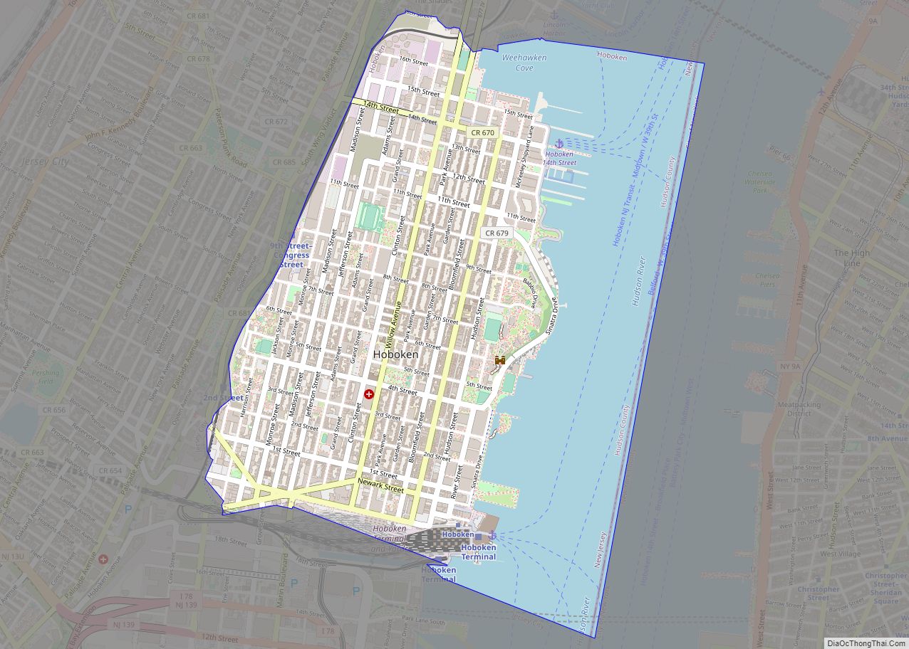
Hoboken Road Map
Hoboken city Satellite Map
Geography
According to the United States Census Bureau, the city has a total area of 2 square miles (5.2 square kilometres), including 1.25 sq mi (3.2 km) of land and 0.75 sq mi (1.9 km) of water (37.50%).
Hoboken lies on the west bank of the Hudson River between Weehawken and Union City to the north and Jersey City (the county seat) to the south and west. Directly across the Hudson River are the Manhattan, New York City neighborhoods of the West Village and Chelsea.
Hoboken is laid out in a grid. North–south streets are named (Washington, Adams, Jefferson, Madison, Monroe, Jackson, Harrison, and Clinton, for example). The numbered streets running east–west start two blocks north of Observer Highway with First Street, with the grid ending close to 16th near Weehawken Cove and the city line. Neighborhoods in Hoboken often have vague definitions making Downtown, Midtown and Uptown subjective. Castle Point (or Stevens Point), The Projects, Hoboken Terminal, and Hudson Tea are distinct enclaves at the city’s periphery. As it transforms from its previous industrial use to a residential district, the “Northwest” is a name being used for that part of the city.
Hoboken’s ZIP Code is 07030 and its area code is 201.
See also
Map of New Jersey State and its subdivision: Map of other states:- Alabama
- Alaska
- Arizona
- Arkansas
- California
- Colorado
- Connecticut
- Delaware
- District of Columbia
- Florida
- Georgia
- Hawaii
- Idaho
- Illinois
- Indiana
- Iowa
- Kansas
- Kentucky
- Louisiana
- Maine
- Maryland
- Massachusetts
- Michigan
- Minnesota
- Mississippi
- Missouri
- Montana
- Nebraska
- Nevada
- New Hampshire
- New Jersey
- New Mexico
- New York
- North Carolina
- North Dakota
- Ohio
- Oklahoma
- Oregon
- Pennsylvania
- Rhode Island
- South Carolina
- South Dakota
- Tennessee
- Texas
- Utah
- Vermont
- Virginia
- Washington
- West Virginia
- Wisconsin
- Wyoming
