D’Lo is a town in Simpson County, Mississippi, United States, along the Strong River. The population was 452 at the 2010 census. It is part of the Jackson, Mississippi metropolitan area.
The town was featured in Life magazine for sending more men per capita to serve in World War II than any other town of its size; 38 percent of the men who lived in D’Lo served.
In 2016 the town was featured on the UP reality TV series, Small Town, Big Mayor.
| Name: | D’Lo town |
|---|---|
| LSAD Code: | 43 |
| LSAD Description: | town (suffix) |
| State: | Mississippi |
| County: | Simpson County |
| Elevation: | 299 ft (91 m) |
| Total Area: | 0.70 sq mi (1.80 km²) |
| Land Area: | 0.70 sq mi (1.80 km²) |
| Water Area: | 0.00 sq mi (0.00 km²) |
| Total Population: | 373 |
| Population Density: | 535.92/sq mi (207.02/km²) |
| ZIP code: | 39062 |
| Area code: | 601 |
| FIPS code: | 2819340 |
| GNISfeature ID: | 0669070 |
| Website: | www.dlowaterpark.com |
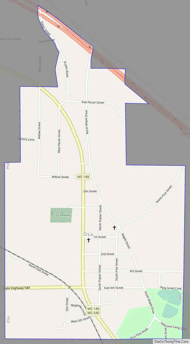
Online Interactive Map
Click on ![]() to view map in "full screen" mode.
to view map in "full screen" mode.
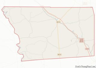
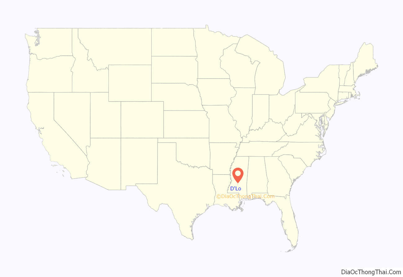
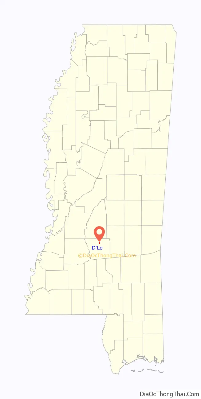
D’Lo location map. Where is D’Lo town?
History
The town of D’Lo was founded by R. W. May on March 1, 1900 when a town plat was registered with the Simpson County Board of Supervisors, March 1, 1900. On August 16, 1901, a village by the name “D’Lo” was incorporated and boundaries identified by Governor of Mississippi. The village of “D’Lo” was raised to the rank of “town” on October 27, 1905 by proclamation and signed by the Governor Mississippi.
The name D’Lo is a modification of the name of the local U.S. Post Office, which was named “Dlo” from 1881 to January 1, 1950. The Post Office was established and approved June 17, 1881 under the name “Dlo”. The first postmaster was May’s wife, Mary Frances May, and the post office was run from May’s home until it moved with the establishment of the town. The name “Dlo” was chosen by the contract postal rider on the Brandon-Westville mail route after the initial choice, “Millhaven”, was rejected by the Post Office Department. Just as the Strong River got its name from a translation of a Choctaw word describing the strong taste of the river water – which has a large amount of tannic acid dissolved in it – “Dlo” derives from a French phrase meaning “Bitter Undrinkable Water”, which appears on an early map of the area. The phrase beginning “De l’eau non potable…” was shortened to “Dlo”, and then “D’Lo.”
The town expanded in 1916 when the Finkbine Lumber Company chose it as the location for a $1,000,000 sawmill plant. Finkbine constructed many houses in the community for their workers, as well as a combination dry goods, hardware, grocery store, farm supply, feed and seed, and general store known as Kew Mercantile Company. During the peak of the Finkbine’s sawmill plant operation, between 1916 and 1930, Millhaven was recognized as the largest town between Jackson and Hattiesburg. It had two large YMCA buildings, a movie theater, ten grocery stores, a furniture store, three appliance dealers, ten gas stations, seven butcher’s markets, a dry cleaner, five cafes, three auto shops, a boat building and cabinet shop, a machine shop, three pharmacies, a bank, lighted basketball courts, professional basketball and baseball teams, and a newspaper called The D’Lo Herald.
The town also had Baptist and Methodist churches, and a three-story brick school with 550 students and 17 teachers. Its three-story Pine View Hospital was considered the best hospital between Jackson and the Mississippi Gulf Coast, as far as equipment and doctors were concerned. During this time the population of Millhaven was estimated to be around 5,000, which made it the second largest milling town in the United States. However, by the 1930s the Finkbine Mill had consumed almost all the timber in the surrounding counties, and the plant was shut down.
With the Finkbine sawmill closed, D’Lo lost jobs and suffered a major decline in population. It took several years for the town’s economy to begin to recover. With the construction of U.S. Route 49 through the town, Lumber companies could reach second-growth of timber in the surrounding areas. A new hardwood sawmill reportedly supplied timber to firms that built weapons and equipment for World War II. Although the mill was effective at keeping the town going for many years, it was never a large enough operation to recoup the huge loss of population. Once with a population of 5,000, during the 1940s, the town had around 400 residents. This is the estimated population in the 21st century.
Of the town’s population of about 400, around 150 males served in the Armed Forces during World War II. About 46 volunteers also served prior to the bombing of Pearl Harbor. So many citizens served in the war that the town’s story was featured in the July 6, 1942 edition of Life magazine. The story featured a picture of two young boys standing in the deserted streets of D’Lo with the headline, “D’Lo Men Have Gone Off to War”, with a caption that stated, “There is a war and a country is in danger. When that happens the men drop what they are doing and go off from the deep southern hamlet of D’Lo, Miss.” A monument located at the town’s community center lists the D’Lo citizens who served during the war.
The name was changed to D’Lo effective January 1, 1950.
D’Lo Town Hall
D’Lo, 2021
Simpson County Historical Society building in D’Lo
Finkbine Lumber Company Sawmill, D’Lo, circa 1920
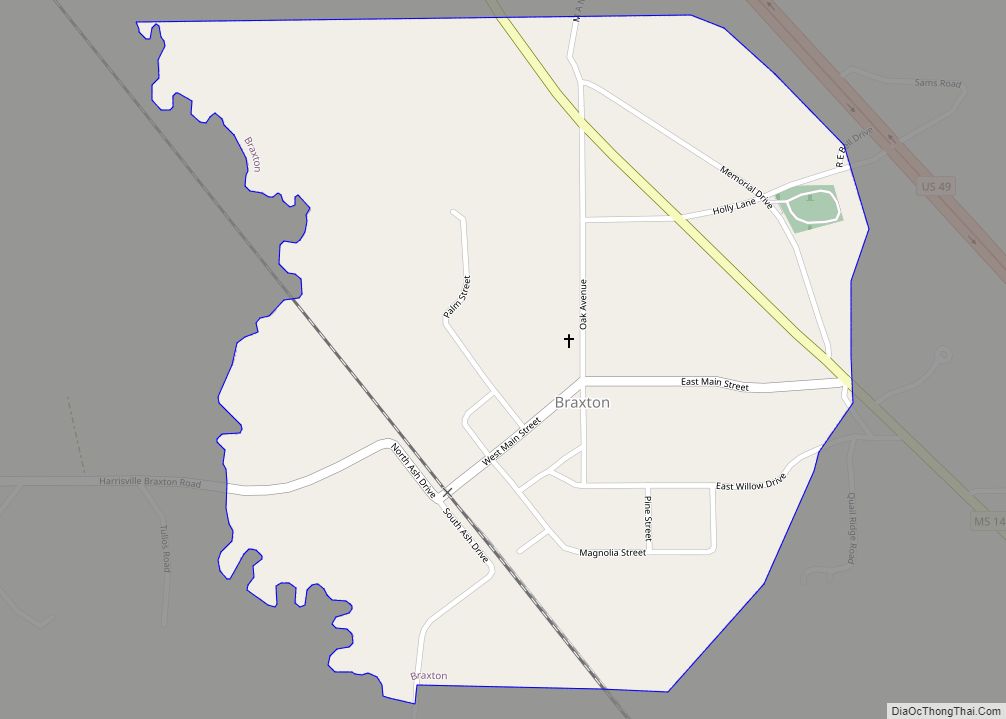
D’Lo Road Map
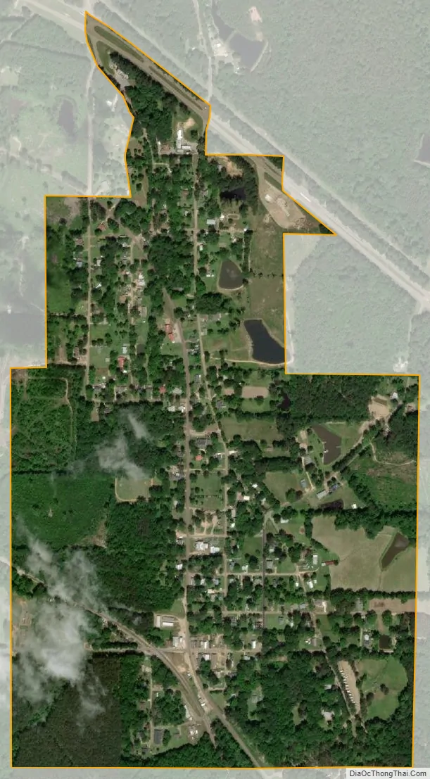
D’Lo city Satellite Map
Geography
According to the United States Census Bureau, the town has a total area of 0.7-square-mile (1.8 km), all land.
See also
Map of Mississippi State and its subdivision:- Adams
- Alcorn
- Amite
- Attala
- Benton
- Bolivar
- Calhoun
- Carroll
- Chickasaw
- Choctaw
- Claiborne
- Clarke
- Clay
- Coahoma
- Copiah
- Covington
- Desoto
- Forrest
- Franklin
- George
- Greene
- Grenada
- Hancock
- Harrison
- Hinds
- Holmes
- Humphreys
- Issaquena
- Itawamba
- Jackson
- Jasper
- Jefferson
- Jefferson Davis
- Jones
- Kemper
- Lafayette
- Lamar
- Lauderdale
- Lawrence
- Leake
- Lee
- Leflore
- Lincoln
- Lowndes
- Madison
- Marion
- Marshall
- Monroe
- Montgomery
- Neshoba
- Newton
- Noxubee
- Oktibbeha
- Panola
- Pearl River
- Perry
- Pike
- Pontotoc
- Prentiss
- Quitman
- Rankin
- Scott
- Sharkey
- Simpson
- Smith
- Stone
- Sunflower
- Tallahatchie
- Tate
- Tippah
- Tishomingo
- Tunica
- Union
- Walthall
- Warren
- Washington
- Wayne
- Webster
- Wilkinson
- Winston
- Yalobusha
- Yazoo
- Alabama
- Alaska
- Arizona
- Arkansas
- California
- Colorado
- Connecticut
- Delaware
- District of Columbia
- Florida
- Georgia
- Hawaii
- Idaho
- Illinois
- Indiana
- Iowa
- Kansas
- Kentucky
- Louisiana
- Maine
- Maryland
- Massachusetts
- Michigan
- Minnesota
- Mississippi
- Missouri
- Montana
- Nebraska
- Nevada
- New Hampshire
- New Jersey
- New Mexico
- New York
- North Carolina
- North Dakota
- Ohio
- Oklahoma
- Oregon
- Pennsylvania
- Rhode Island
- South Carolina
- South Dakota
- Tennessee
- Texas
- Utah
- Vermont
- Virginia
- Washington
- West Virginia
- Wisconsin
- Wyoming