South Jordan is a city in south central Salt Lake County, Utah, United States, 18 miles (29 km) south of Salt Lake City. Part of the Salt Lake City metropolitan area, the city lies in the Salt Lake Valley along the banks of the Jordan River between the 10,000-foot (3,000 m) Oquirrh Mountains and the 11,000-foot (3,400 m) Wasatch Mountains. The city has 3.5 miles (5.6 km) of the Jordan River Parkway that contains fishing ponds, trails, parks, and natural habitats. The Salt Lake County fair grounds and equestrian park, 67-acre (27 ha) Oquirrh Lake, and 37 public parks are located inside the city. As of 2020, there were 77,487 people in South Jordan.
Founded in 1859 by Mormon settlers and historically an agrarian town, South Jordan has become a rapidly growing bedroom community of Salt Lake City. Kennecott Land, a land development company, has recently begun construction on the master-planned Daybreak Community for the entire western half of South Jordan, potentially doubling South Jordan’s population. South Jordan was the first municipality in the world to have two temples of the Church of Jesus Christ of Latter-day Saints (Jordan River Utah Temple and Oquirrh Mountain Utah Temple), it now shares that distinction with Provo, Utah. The city has two TRAX light rail stops, as well as one commuter rail stop on the FrontRunner.
| Name: | South Jordan city |
|---|---|
| LSAD Code: | 25 |
| LSAD Description: | city (suffix) |
| State: | Utah |
| County: | Salt Lake County |
| Incorporated: | November 8, 1935 |
| Elevation: | 4,439 ft (1,353 m) |
| Total Area: | 22.31 sq mi (57.77 km²) |
| Land Area: | 22.22 sq mi (57.54 km²) |
| Water Area: | 0.09 sq mi (0.23 km²) |
| Total Population: | 77,487 |
| Population Density: | 3,452.07/sq mi (1,332.86/km²) |
| ZIP code: | 84009, 84095 |
| Area code: | 385, 801 |
| FIPS code: | 4970850 |
| GNISfeature ID: | 1432728 |
| Website: | www.sjc.utah.gov |
Online Interactive Map
Click on ![]() to view map in "full screen" mode.
to view map in "full screen" mode.
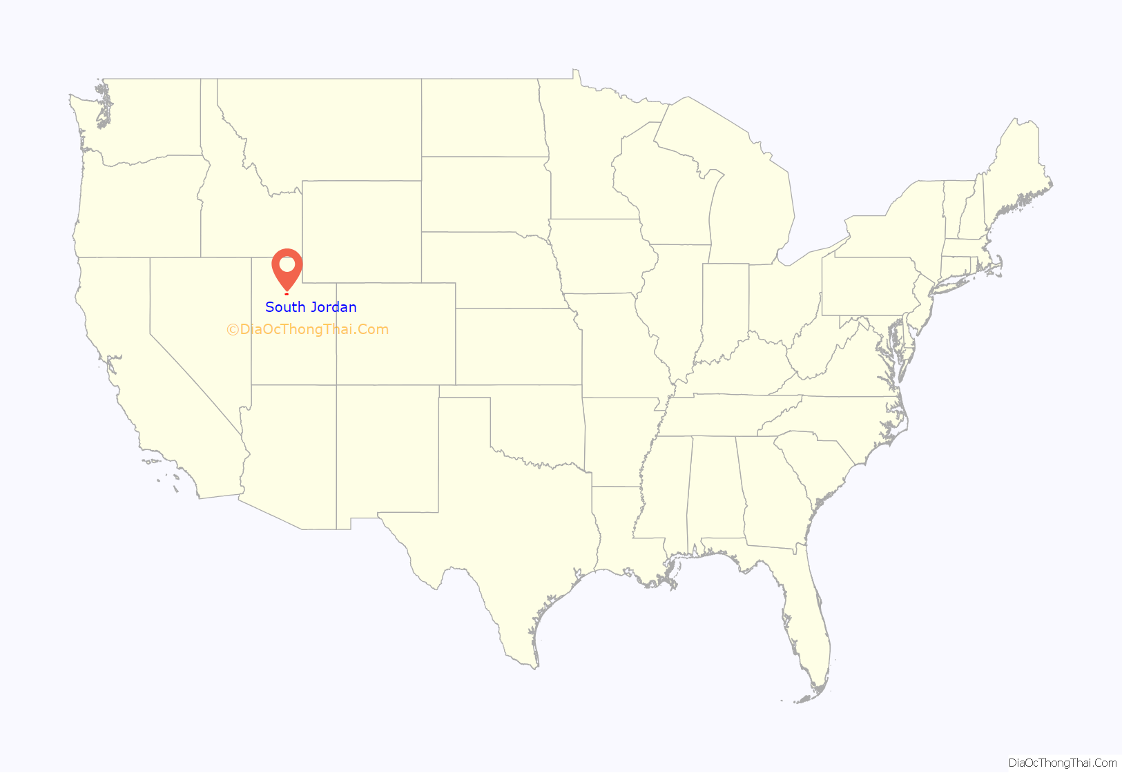
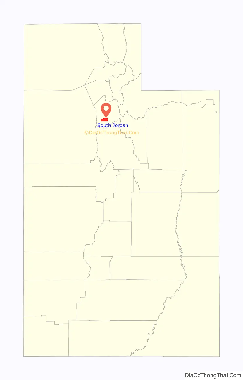
South Jordan location map. Where is South Jordan city?
History
Pre-European
The first known inhabitants were members of the Desert Archaic Culture who were nomadic hunter-gatherers. From 400 A.D. to around 1350 A.D., the Fremont people settled into villages and farmed corn and squash. Changes in climatic conditions to a cooler, drier period and the movement into the area of ancestors of the Ute, Paiute, and Shoshone, led to the disappearance of the Fremont people. When European settlers arrived, there were no permanent Native American settlements in the Salt Lake Valley, but the area bordered several tribes – the territory of the Northwestern Shoshone to the north, the Timpanogots band of the Utes to the south in Utah Valley, and the Goshutes to the west in Tooele Valley.
The only recorded trapper to lead a party through the area was Étienne Provost, a French Canadian. In October 1824, Provost’s party was lured into an Indian camp somewhere along the Jordan River north of Utah Lake. The people responsible for the attack were planning revenge against Provost’s party for an earlier unexplained incident involving other trappers. Provost escaped, but his men were caught off-guard and fifteen of them were killed.
Early Mormon settlement
On July 22, 1847, an advanced party of the first Mormon pioneers entered the valley and immediately began to irrigate land and explore the area with a view to establishing new settlements. Alexander Beckstead, a blacksmith from Ontario, Canada, moved his family to the West Jordan area in 1849, and became the first of his trade in the south Salt Lake Valley. He helped dig the first ditch to divert water from the Jordan River, powering Archibald Gardner’s flour mill. In 1859, Beckstead became the first settler of South Jordan by moving his family along the Jordan River where they lived in a dugout cut into the west bluffs above the river. The flood plain of the Jordan was level, and could be cleared for farming if a ditch was constructed to divert river water along the base of the west bluff. Beckstead and others created the 2.5-mile (4.0 km) “Beckstead Ditch”, which is still in use for irrigation of city parks and Mulligan’s golf course.
In 1863, the South Jordan LDS Branch was organized as a branch of the West Jordan Ward, giving South Jordan its name. The Branch consisted of just nine families. A school was built in 1864 out of adobe and also served as the LDS Meetinghouse for the South Jordan Branch. As South Jordan grew, a new and larger building was constructed in 1873 on the east side of the site of the present-day cemetery. It had an upper and lower entrance with a granite foundation using left-over materials brought from the granite quarry at the mouth of Little Cottonwood Canyon. The upper story was made of oversized adobe bricks. The main hall had curtains which could be pulled to section off the hall for classes. The meetinghouse also served as the “ward” school when it was held during the fall and winter months. It came to be known as the “Mud Temple”, and was in use until 1908.
In 1876, work was completed on the South Jordan Canal which took water out of the Jordan River in Bluffdale and brought it above the river bluffs for the first time. As a result of the new canal, most of the families moved up away from the river onto the “flats” above the river which they could now irrigate. In 1881, the Utah and Salt Lake Canal was completed. It runs parallels to the west side of today’s Redwood Road. With the completion of the canal system, greater acreage could be farmed, which led to the area’s population increasing.
Twentieth century
In the late 1890s, alfalfa hay was introduced and took the place of tougher native grasses which had been used up to that point for feed for livestock. In good years, alfalfa could produce three crops that were stored for winter. Sugar beets were introduced to South Jordan around 1910. Farmers liked sugar beets because they could be sold for cash at the Utah-Idaho Sugar Company factory in West Jordan.
A big celebration was held on January 14, 1914, to commemorate the arrival of electrical power, the addition of a water tank and supply system for indoor pumping and a new park for South Jordan. By the 1930s, the area needed a water tank to store water for residents living further west. The only way to get a federal grant was to incorporate and become a city. Citizens voted to incorporate on November 8, 1935, and immediately issued bonds to obtain money for the water tank. The city was initially governed by a Town Board with responsibilities over parks, water and the cemetery. In 1978, the city moved to a mayor-council form of government and assumed local supervision of police, fire, road and building inspections from Salt Lake County.
One of the worst school bus accidents in United States history occurred on December 1, 1938. A bus loaded with 38 students from South Jordan, Riverton, and Bluffdale crossed in front of an oncoming train that was obscured by fog and snow. The bus was broadsided killing the bus driver and 23 students. The concern about bus safety from the South Jordan accident led to changes in state and eventually federal law mandating that buses stop and open the doors before proceeding into a railroad crossing. The same railroad crossing was the site of many other crashes in the following years with the last deadly crash occurring on December 31, 1995, when three teens died while crossing the tracks in their car. The crossing was finally closed, but not until crashes occurred in 1997 and 2002.
In 1950, Salt Lake County had 489,000 acres (198,000 ha) devoted to farming. But by 1992, due to increasing population, land devoted to farming had decreased to 108,000 acres (44,000 ha). As a result of this urbanization, South Jordan’s economy went from agrarian to being a bedroom community of Salt Lake City. Kennecott Land began a development in 2004 called Daybreak, which is a 4,200-acre (1,700 ha) planned community that will contain more than 20,000 homes and includes commercial and retail space. In 2022, the remaining 1,300-acre (530 ha) undeveloped land was sold to Larry H. Miller Group. In 1981, the LDS Jordan River Utah Temple was completed. In 2009, the LDS Oquirrh Mountain Utah Temple was completed and became the second temple to be built in South Jordan. South Jordan was the first city in the world to have two LDS Temples, Oquirrh Mountain Utah Temple and the Jordan River Utah Temple, the second city being Provo, Utah.
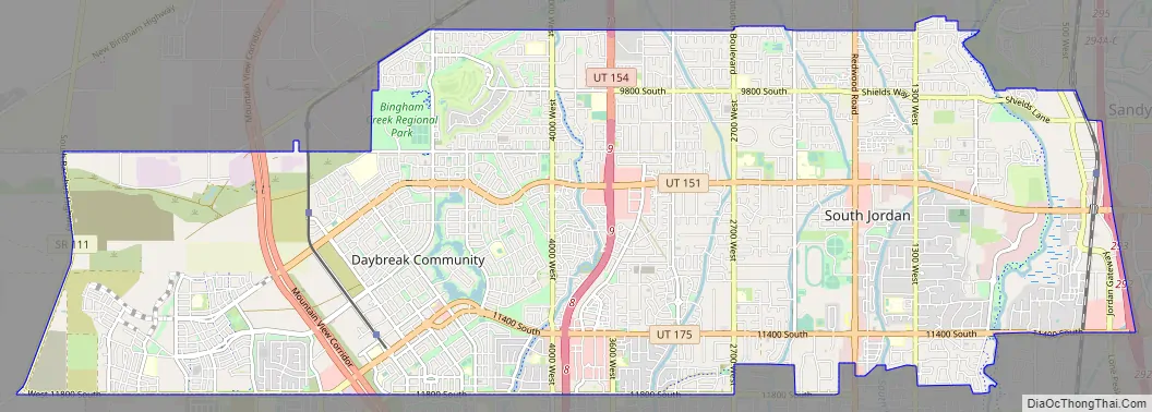
South Jordan Road Map
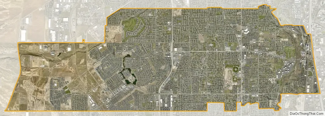
South Jordan city Satellite Map
Geography
According to the United States Census Bureau, the city has a total area of 22.22 square miles (58 km), of which 0.09 square miles (0.23 km), 0.4 percent, is water.
The relative flatness of South Jordan is due to lacustrine sediments of a pleistocene lake called Lake Bonneville. Lake Bonneville existed from 75,000 to 8,000 years ago; at its peak some 30,000 years ago, the lake reached an elevation of 5,200 feet (1,600 m) above sea level and had a surface area of 19,800 square miles (51,000 km). The elevation of South Jordan ranges from approximately 4,300 feet (1,300 m) near the Jordan River in the east and rises gently to the foothills of the Oquirrh Mountains at 5,200 feet (1,600 m).
See also
Map of Utah State and its subdivision: Map of other states:- Alabama
- Alaska
- Arizona
- Arkansas
- California
- Colorado
- Connecticut
- Delaware
- District of Columbia
- Florida
- Georgia
- Hawaii
- Idaho
- Illinois
- Indiana
- Iowa
- Kansas
- Kentucky
- Louisiana
- Maine
- Maryland
- Massachusetts
- Michigan
- Minnesota
- Mississippi
- Missouri
- Montana
- Nebraska
- Nevada
- New Hampshire
- New Jersey
- New Mexico
- New York
- North Carolina
- North Dakota
- Ohio
- Oklahoma
- Oregon
- Pennsylvania
- Rhode Island
- South Carolina
- South Dakota
- Tennessee
- Texas
- Utah
- Vermont
- Virginia
- Washington
- West Virginia
- Wisconsin
- Wyoming