Prince George’s County (often shortened to PG County) is a county located in the U.S. state of Maryland bordering the eastern portion of Washington, D.C. As of the 2020 U.S. census, the population was 967,201, making it the second-most populous county in Maryland, behind Montgomery County. The 2020 census counted an increase of nearly 104,000 in the previous ten years. Its county seat is Upper Marlboro. It is the largest and the second most affluent African American-majority county in the United States, with five of its communities identified in a 2015 top ten list.
Prince George’s County is included in the Washington metropolitan area. The county also hosts many federal governmental facilities, such as Joint Base Andrews and the United States Census Bureau headquarters.
| Name: | Prince George’s County |
|---|---|
| FIPS code: | 24-033 |
| State: | Maryland |
| Founded: | April 23, 1696 |
| Named for: | Prince George of Denmark |
| Seat: | Upper Marlboro |
| Largest city: | Bowie |
| Total Area: | 499 sq mi (1,290 km²) |
| Land Area: | 483 sq mi (1,250 km²) |
| Total Population: | 967,201 |
| Population Density: | 1,900/sq mi (700/km²) |
| Time zone: | UTC−5 (Eastern) |
| Summer Time Zone (DST): | UTC−4 (EDT) |
| Website: | www.princegeorgescountymd.gov |
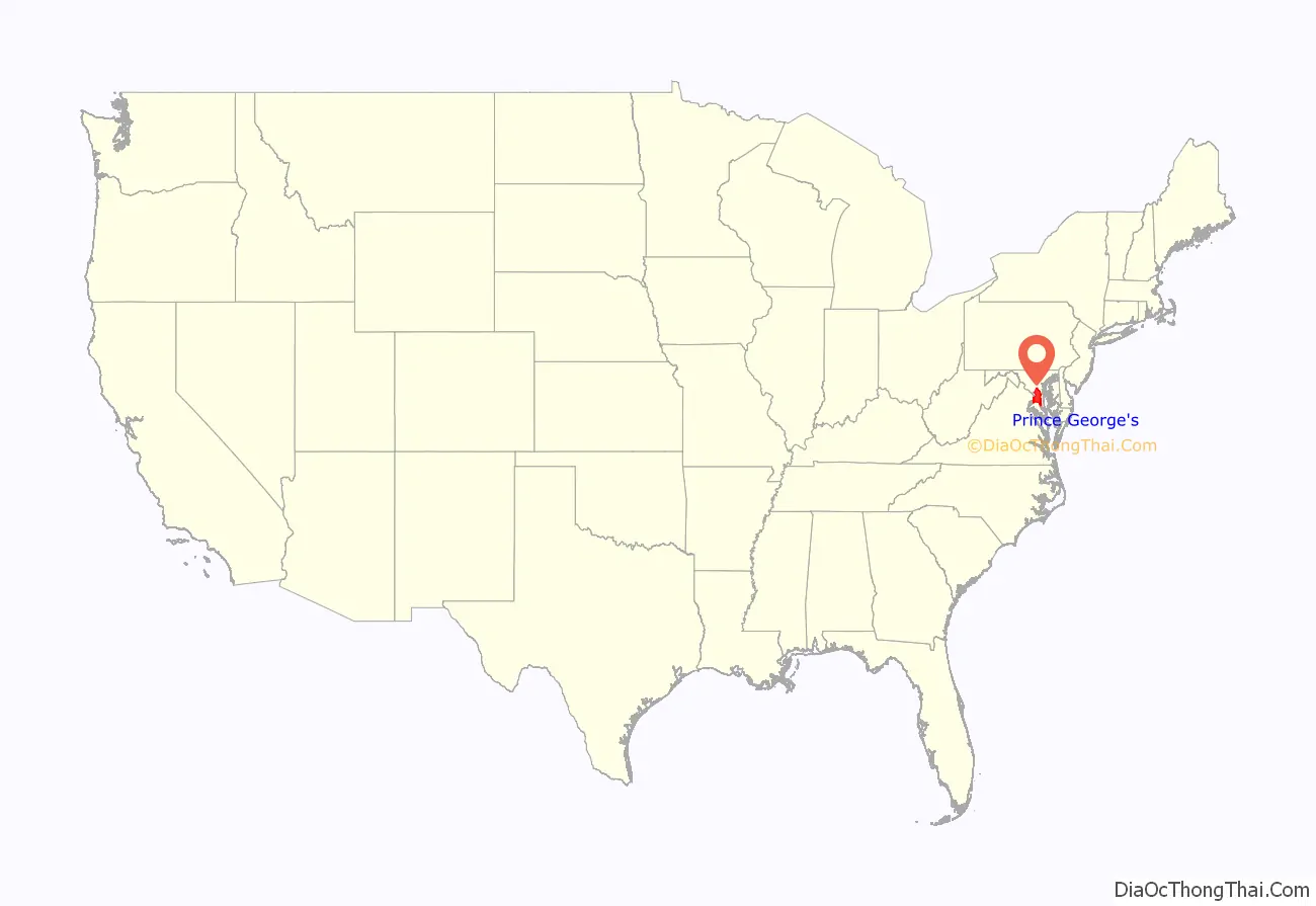
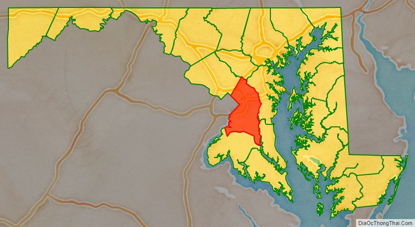
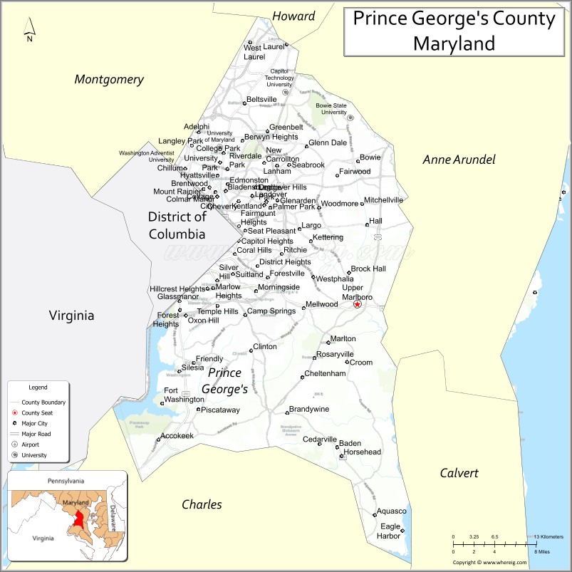
Prince George’s County location map. Where is Prince George’s County?
History
The Cretaceous Era brought dinosaurs to the area that left fossils now preserved in a 7.5-acre (3.0 ha) park in Laurel. The site, which among other finds has yielded fossilized teeth from Astrodon and Priconodon species, has been called the most prolific in the eastern United States.
In the mid to late Holocene era, the area was occupied by Paleo-Native Americans and then, later, Native Americans. When the first European settlers arrived, what is now Prince George’s County was inhabited by people of the Piscataway Indian Nation. Three branches of the tribe are still living today, two of which are headquartered in Prince George’s County.
17th century
Prince George’s County was created by the English Council of Maryland in the Province of Maryland in April 1696 from portions of Charles and Calvert counties. The county was divided into six districts referred to as “Hundreds”: Mattapany, Petuxant, Collington, Mount Calvert, Piscattoway and New Scotland.
18th century
A portion was detached in 1748 to form Frederick County. Because Frederick County was subsequently divided to form the present Allegany, Garrett, Montgomery, and Washington counties, all of these counties in addition were derived from what had up to 1748 been Prince George’s County.
In 1791, portions of Prince George’s County were ceded to form the new District of Columbia (along with portions of Montgomery County, Maryland and parts of Northern Virginia that were later returned to Virginia).
19th century
During the War of 1812, the British marched through the county by way of Bladensburg to burn the White House. On their return, they kidnapped a prominent doctor, William Beanes. Lawyer Francis Scott Key was asked to negotiate for his release, which resulted in his writing “The Star-Spangled Banner”.
Prince George’s County had the highest population of slaves within the state of Maryland. These enslaved Africans engaged in forced labor on tobacco farms and plantations throughout Prince George’s County.
During the Civil War, hundreds of enslaved Black men in Prince George’s County were given freedom in exchange for joining the Union Army and fighting in Colored units against Confederate Forces. When Abraham Lincoln ordered the end of slavery in America, he did not free the slaves in Maryland because he was concerned that slave owning Maryland would revolt and Washington D.C. would then be surrounded by Confederate forces. However John Pendleton Kennedy, a Maryland politician who became an abolitionist after watching a speech by Frederick Douglass, led a referendum campaign to end slavery in the state. In 1864, the citizens of Maryland voted to end slavery. However the state was so divided that the referendum won by only 1,000 votes. Lincoln then ordered the Union Army to enforce the ban in Maryland and all enslaved people in the state were freed.
After the Civil War, many African Americans attempted to become part of Maryland politics, but were met with violent repression after the fall of Reconstruction.
In April 1865, John Wilkes Booth made his escape through Prince George’s County while en route to Virginia after killing President Abraham Lincoln.
20th century
The proportion of African Americans declined during the first half of the 20th century, but was renewed to over 50% in the early 1990s when the county again became majority African American. The first African American County Executive was Wayne K. Curry, elected in 1994.
On July 1, 1997, the Prince George’s County section of the city of Takoma Park, which straddled the boundary between Prince George’s and Montgomery counties, was transferred to Montgomery County. This was done after city residents voted in a referendum to be under the sole jurisdiction of Montgomery County, and subsequent approval by both counties and the Maryland General Assembly. This was the first change in Montgomery/Prince George’s County line boundaries since 1968, when the City of Laurel was unified in Prince George’s County; additional legislation was proposed in 1990 for a technical correction, though may not have achieved enactment.
21st century
The county’s population nearly reached one million residents in the 2020 census. It is the largest and highest-income Black-majority county in the United States. Hispanic residents grew in number to 21% of the total population.
The county experienced a dramatic drop in crime, including record drops in violent crime, although in 2021 and 2022, violent crime increased by 30%. From 2020 to mid-2022 over 2,200 residents died of COVID-19, over 19,000 county residents were left with long-term post-COVID symptoms and over 193,000 COVID infections had been recorded.
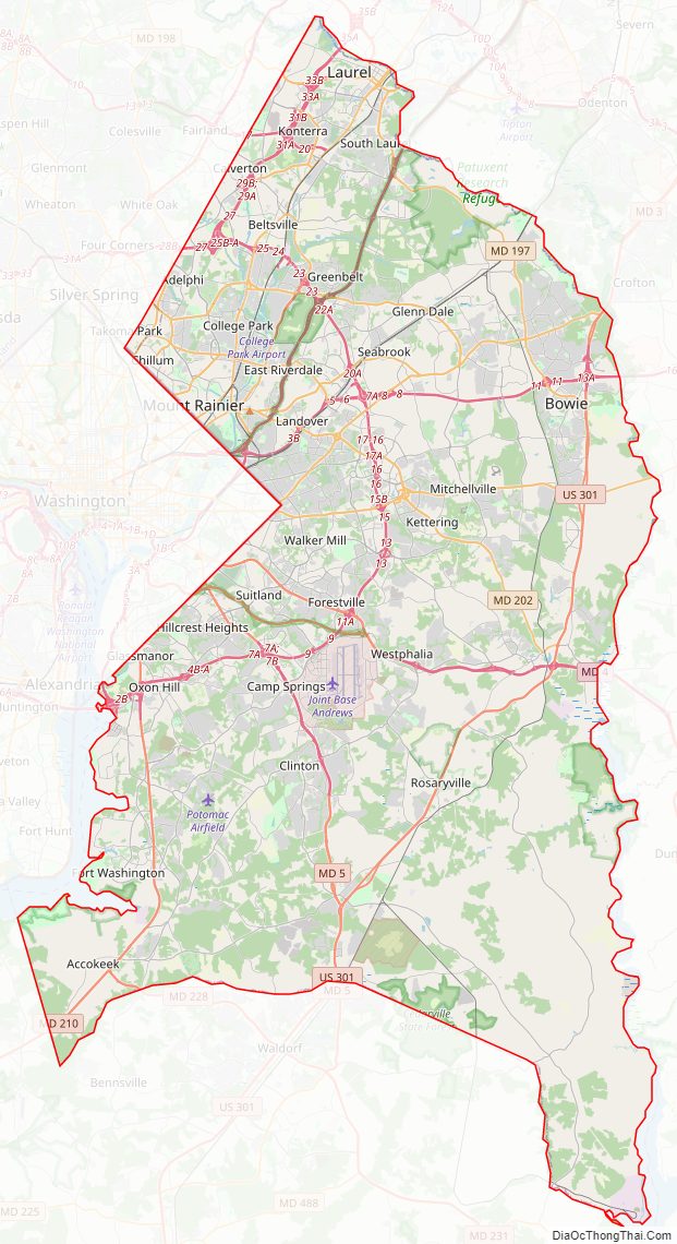
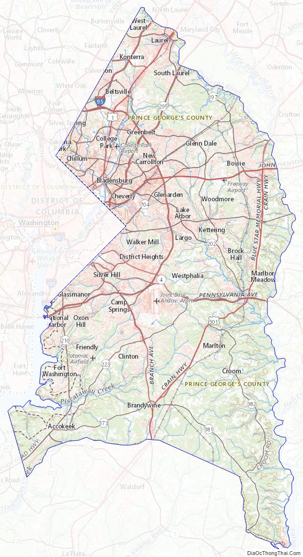
Prince George’s County Road Map
Geography
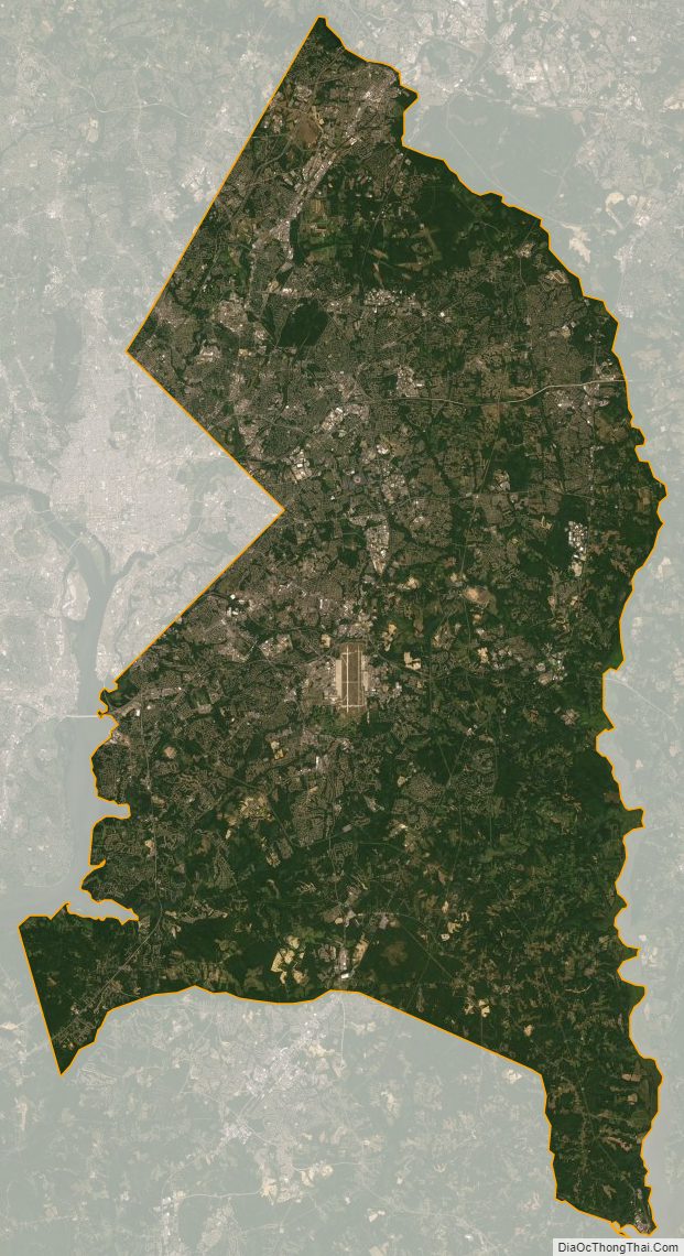
According to the U.S. Census Bureau, the county has a total area of 499 square miles (1,290 km), of which 483 square miles (1,250 km) is land and 16 square miles (41 km) (3.2%) is water.
Prince George’s County lies in the Atlantic coastal plain, and its landscape is characterized by gently rolling hills and valleys. Along its western border with Montgomery County, Adelphi, Calverton and West Laurel rise into the piedmont, exceeding 300 feet (91 m) in elevation.
The Patuxent River forms the county’s eastern border with Howard, Anne Arundel, Charles and Calvert counties.
Regions
Terrain, culture, and demographics differ significantly by location within the county. There are five key regions to Prince George’s County: North County, Central County, the Rural Tier, the Inner Beltway, and South County. These regions are not formally defined, however, and the terms used to describe each area can vary greatly. In the broadest terms, the county is generally divided into North County and South County with U.S. Route 50 serving as the dividing line.
Southern Prince George’s county is also considered to be a part of the Southern Maryland region.
Northern Prince George’s County includes Laurel, Beltsville, Adelphi, College Park and Greenbelt. This area of the county is anchored by the Capital Beltway and the Baltimore–Washington Parkway. Laurel is experiencing a population boom with the construction of the Inter-County Connector. The key employers in this region are the University of Maryland, Beltsville Agricultural Research Center, and NASA-Goddard Space Flight Center. Areas of geographic distinction include Greenbelt Park, a wooded reserve adjacent to the planned environmental community of Greenbelt, and University Park, a collection of historic homes adjacent to the University of Maryland. Riversdale Mansion, along with the historic homes of Berwyn Heights, Mt. Rainier and Hyattsville, along with Langley Park are also located in this area. Lake Artemesia and the surrounding park were constructed during the completion of the Washington Metro Green Line, and it incorporates a stocked fishing lake and serves as the trail-head for an extensive Anacostia Tributary Trails system that runs along the Anacostia River and its tributaries. The south and central tracts of the Patuxent Wildlife Research Center also lie in this part of the county; the north tract lies north of the Patuxent River in Anne Arundel County.
Central County, located on the eastern outskirts of the Capital Beltway, consists of Mitchellville, Woodmore, Greater Upper Marlboro, Springdale, Largo, and Bowie. According to the 2010 census, it has generally been the fastest growing region of the county. Mitchellville is named for a wealthy African American family, the Mitchells, who owned a large portion of land in this area of the county. Central Avenue, a major exit off the I-95 beltway, running east to west, is one of two main roads in this portion of the county. The other major roadway is Old Crain Highway, which runs north to south along the eastern portion of the county. The Newton White Mansion on the grounds is a popular site for weddings and political events. Bowie State University and Prince George’s Community College are in the Central region.
The inner beltway communities of Capitol Heights, District Heights, Fairmont Heights, Forestville, Suitland, and Seat Pleasant border the neighboring District of Columbia’s northeastern and southeastern quadrants. The area has easy access to Metro’s blue line, commercial centers, Maryland Route 214, Interstate 95/Interstate 495 (Capital Beltway). Protected bike trails connect residents to the Bladensburg waterfront, Kenilworth parks, and downtown D.C. Fairmont Heights is the second oldest African-American-majority municipality in Prince George’s County. The Fairmount Heights Historic District was added to the National Register of Historic Places in 2011.
Bowie is best known as a planned Levittown. William Levitt in the 1960s built traditional homes, as well as California contemporaries along U.S. Route 50, the key highway to the eastern shore and the state capital of Annapolis. Bowie has currently grown to be the largest city in Prince George’s County, with more than 50,000 people. It also has a large Caucasian population, compared to much of the county (48% of the population). Housing styles vary from the most contemporary to century-old homes in Bowie’s antique district (formerly known as Huntingtown), where the town of Bowie began as a haven for thoroughbred horse racing. Areas of geographic distinction include the Oden Bowie Mansion, Allen Pond, key segments of the Washington, Baltimore and Annapolis Trail, as well as planned parks, lakes and walking trails.
Prince George’s rural tier was designated “in the 2002 General Plan as an area where residential growth would be minimal”; it may be found in the area well beyond the Beltway to the east and south of central county, bounded on the north by U.S. Route 50, the west by the communities Accokeek and Fort Washington, and the east by the Patuxent River. Prince George’s origins are in this part of the county. Most of this area contains the unincorporated parishes, villages and lost towns of Prince George’s County. Largely under postal designations of “Upper Marlboro” or “Brandywine“, in truth the town of Upper Marlboro is more central county in character, though it is the post office location for various rural settlements. (The names of these unincorporated areas are listed below in the towns section of this article). Since 1721 Upper Marlboro has been the county seat of government, with families that trace their lineage back to Prince George’s initial land grants and earliest governing officials. Names like Clagett, Sasscer, King James and Queen Anne pepper the streets.
The rural tier has been the focus of orchestrated efforts by residents and county government to preserve its rural character and environmental integrity. Under the Maryland-National Capital Park and Planning Commission (M-NCPPC), Patuxent River Park is the largest natural preserve and provides public access for birdwatching and viewing the rural tier’s natural waterfront vistas. In season, the park’s Jug Bay Natural Area and the Patuxent Riverkeeper in Queen Anne both offer canoeing and kayaking rentals on the Patuxent. The county’s largest collection of tobacco planter mansions and preserved homes are in the rural tier, some managed by the M-NCPPC. Many rural tier roads have scenic highway preservation status; a fall drive yields exceptional beauty along the Patuxent valley’s Leeland Road, Croom Road, Clagett’s Landing Rd., Mill Branch Rd., Queen Anne Rd., and Brandywine Rd. Walking access along roads in this area is very limited, because most property along the roads remains in private ownership. However, walking is much more accessible in the widespread M-NCPPC lands and trails and state holdings in the Patuxent valley, such as Merkle Wildlife Sanctuary and Rosaryville State Park, both popular among hikers and mountain bikers.
South County is a blend of the greenery of the rural tier and the new development of central county. The communities of Clinton, Oxon Hill, Temple Hills and Fort Washington are the largest areas of south county. It is the only portion of Prince George’s County to enjoy the Potomac River waterfront, and that geographic distinction has yielded the rise of the National Harbor project: a town center and riverside shopping and living development on the Potomac. The National Harbor, and its associated entertainment (MGM National Harbor) and shopping (Tanger Outlets) districts, have become a major tourist and convention attraction, with significant hotel accommodations, eateries and shopping. Together, these projects were built on land formerly occupied by the Salubria plantation, where a 14-year-old slave girl poisoned her owner, John H. Bayne, and his family in 1831. Water taxi service connects National Harbor to other destinations along the Potomac. Several historic sites, including Jones Point Lighthouse, can be viewed from the harbor front. Piscataway Park in Accokeek preserves many acres of woodland and wetlands along the Potomac River opposite Mount Vernon, Virginia. River Road in Fort Washington also yields great views of the Potomac. Fort Washington Park was a major battery and gives access to the public for tours of the fort, scenic access to the river and other picnic grounds. Oxon Hill Manor offers a working farm and plantation mansion for touring; His Lordship’s Kindness is another major historic home. Also, Fort Foote is an old American Civil War fort and tourist destination.
Adjacent counties and independent cities
- Anne Arundel County (east)
- Calvert County (southeast)
- Charles County (south)
- Howard County (north)
- Montgomery County (northwest)
- Fairfax County, Virginia (southwest)
- Alexandria, Virginia (southwest)
- Washington, D.C. (west)
Prince George’s and Montgomery Counties share a bi-county planning and parks agency in the M-NCPPC and a public bi-county water and sewer utility in the Washington Suburban Sanitary Commission
National protected areas
- Fort Washington Park
- Greenbelt Park
- Patuxent Wildlife Research Refuge (part)
- Piscataway Park
- Cedarville State Forest (whose main entrance is in Prince George’s county)
Prince George’s County Topographic Map
Prince George’s County Satellite Map
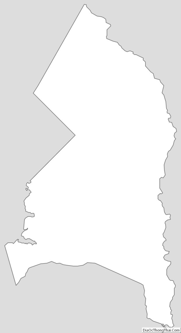
Prince George’s County Outline Map