Key West (Spanish: Cayo Hueso) is an island in the Straits of Florida, within the U.S. state of Florida. Together with all or parts of the separate islands of Dredgers Key, Fleming Key, Sunset Key, and the northern part of Stock Island, it constitutes the City of Key West.
The island of Key West is about 4 miles (6 kilometers) long and 1 mile (2 km) wide, with a total land area of 4.2 square miles (11 km). It lies at the southernmost end of U.S. Route 1, the longest north–south road in the United States. Key West is about 95 miles (153 km) north of Cuba at their closest points. It is also 130 miles (210 km) southwest of Miami by air, about 165 miles (266 km) by road, and 106 miles (171 km) north-northeast of Havana.
The city of Key West is the county seat of Monroe County, which includes a majority of the Florida Keys and part of the Everglades. The total land area of the city is 5.6 square miles (14.5 km). The population within the city limits was 26,444 at the 2020 census. The official city motto is “One Human Family”.
Key West is the southernmost city in the contiguous United States and the westernmost island connected by highway in the Florida Keys. Duval Street, its main street, is 1.1 miles (1.8 km) in length in its 14-block-long crossing from the Gulf of Mexico to the Straits of Florida and the Atlantic Ocean. Key West is the southern terminus of U.S. Route 1, State Road A1A, the East Coast Greenway and, before 1935, the Florida East Coast Railway. Key West is a port of call for many passenger cruise ships. The Key West International Airport provides airline service. Naval Air Station Key West is an important year-round training site for naval aviation due to the tropical weather, which is also the reason Key West was chosen as the site of President Harry S. Truman’s Winter White House. The central business district is located along Duval Street and includes much of the northwestern corner of the island.
| Name: | Key West city |
|---|---|
| LSAD Code: | 25 |
| LSAD Description: | city (suffix) |
| State: | Florida |
| County: | Monroe County |
| Elevation: | 5 ft (2 m) |
| Total Area: | 7.21 sq mi (18.67 km²) |
| Land Area: | 5.60 sq mi (14.50 km²) |
| Water Area: | 1.61 sq mi (4.17 km²) |
| Total Population: | 26,444 |
| Population Density: | 4,722.99/sq mi (1,823.44/km²) |
| FIPS code: | 1236550 |
| GNISfeature ID: | 0294048 |
| Website: | www.cityofkeywest-fl.gov |
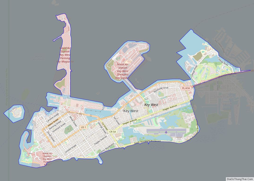
From the Harry S. Truman Little White House to the Ernest Hemingway Home and Museum, explore the sights and sounds of Key West with this comprehensive map. Find out what to do, where to go, and how to get there with this interactive map.
If you’re looking for an unforgettable vacation experience, look no further than Key West! With this Key West map collection, you’ll have all the information you need to make the most of your stay.
Discover the beauty of Key West with this comprehensive Key West map collection. From highways/roads to things to do and reference information, this map has it all. Explore the sights and sounds of the southernmost point in the US with this interactive map and make the most of your stay!
Online Interactive Map
Click on ![]() to view map in "full screen" mode.
to view map in "full screen" mode.
The city of Key West, Florida is a great place to visit, with a laid-back, tropical feel. The city is also home to several unique attractions that are worth visiting like the Ernest Hemingway Home and Museum. Discover key attractions, restaurants, and more in Key West Florida with this interactive map.
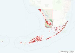
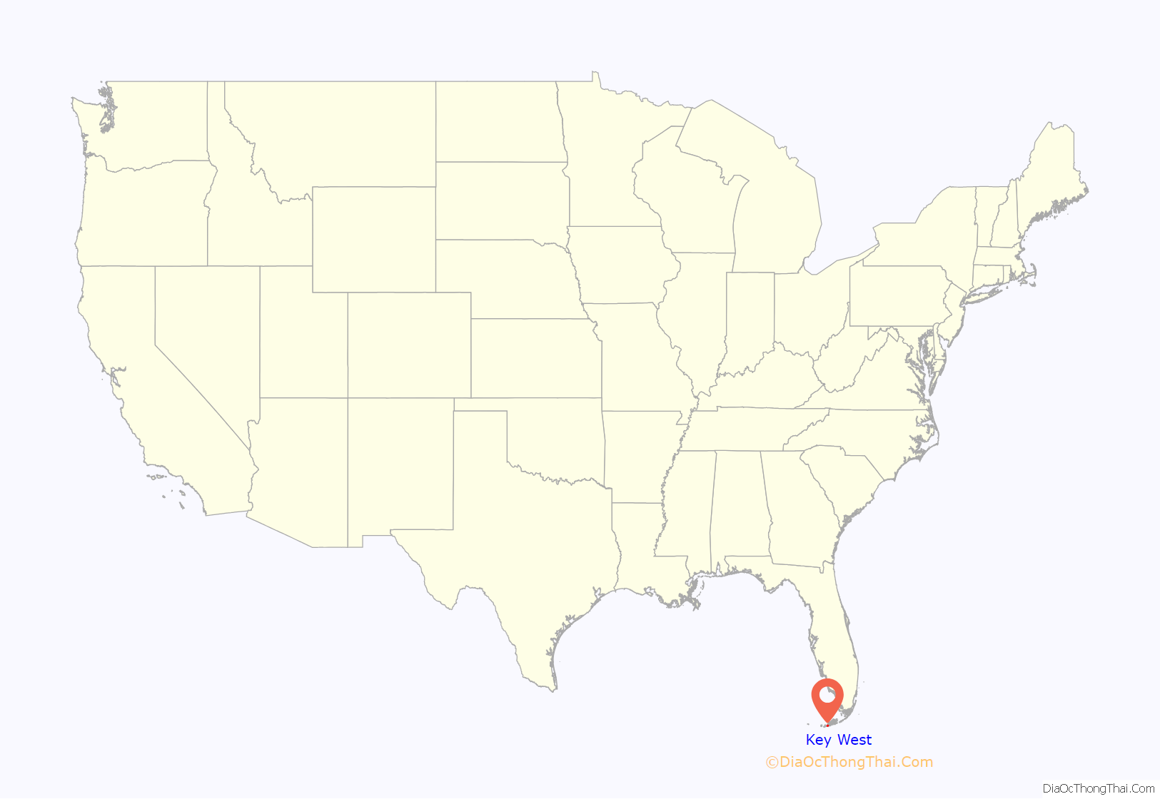
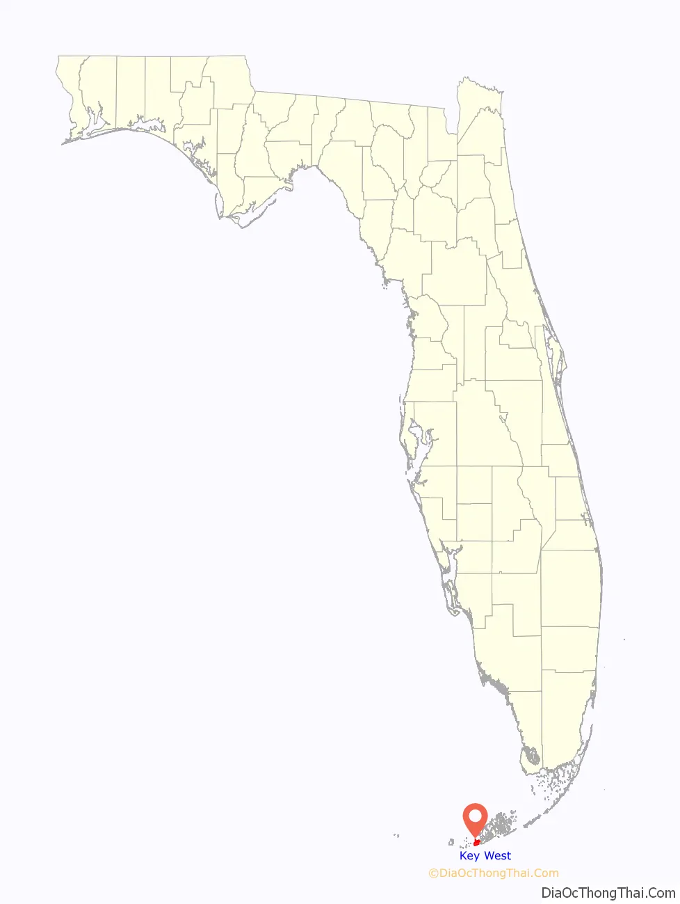
Key West location map. Where is Key West city?
History
Precolonial and colonial times
At various times before the 19th century, people who were related or subject to the Calusa and the Tequesta inhabited Key West. The last Native American residents of Key West were Calusa refugees who were taken to Cuba when Florida was transferred from Spain to Great Britain in 1763.
Cayo Hueso (Spanish pronunciation: [ˈkaʝo ˈweso]) is the original Spanish name for the island of Key West. It literally means “bone cay”, cay referring to a low island or reef. It is said that the island was littered with the remains (bones) of prior native inhabitants, who used the isle as a communal graveyard. This island was the westernmost Key with a reliable supply of water.
Between 1763, when Great Britain took control of Florida from Spain, and 1821, when the United States took possession of Florida from Spain, there were few or no permanent inhabitants anywhere in the Florida Keys. Cubans and Bahamians regularly visited the Keys, the Cubans primarily to fish, while the Bahamians fished, caught turtles, cut hardwood timber, and salvaged wrecks. Smugglers and privateers also used the Keys for concealment. In 1766 the British governor of East Florida recommended that a post be set up on Key West to improve control of the area, but nothing came of it. During both the British and Spanish periods no nation exercised de facto control. The Bahamians apparently set up camps in the Keys that were occupied for months at a time, and there were rumors of permanent settlements in the Keys by 1806 or 1807, but the locations are not known. Fishermen from New England started visiting the Keys after the end of the War of 1812, and may have briefly settled on Key Vaca in 1818.
Ownership claims
In 1815, the Spanish governor of Cuba in Havana deeded the island of Key West to Juan Pablo Salas, an officer of the Royal Spanish Navy Artillery posted in Saint Augustine, Florida. After Florida was transferred to the United States in 1821, Salas was so eager to sell the island that he sold it twice – first for a sloop valued at $575 to a General John Geddes, a former governor of South Carolina, and then to a U.S. businessman John W. Simonton, during a meeting in a Havana café on January 19, 1822, for the equivalent of $2,000 in pesos in 1821. Geddes tried in vain to secure his rights to the property before Simonton who, with the aid of some influential friends in Washington, was able to gain clear title to the island. Simonton had wide-ranging business interests in Mobile, Alabama. He bought the island because a friend, John Whitehead, had drawn his attention to the opportunities presented by the island’s strategic location. John Whitehead had been stranded in Key West after a shipwreck in 1819 and he had been impressed by the potential offered by the deep harbor of the island. The island was indeed considered the “Gibraltar of the West” because of its strategic location on the 90-mile (140 km)–wide deep shipping lane, the Straits of Florida, between the Atlantic Ocean and the Gulf of Mexico.
On March 25, 1822, Lt. Commander Matthew C. Perry sailed the schooner USS Shark to Key West and planted the U.S. flag, claiming the Keys as United States property. No protests were made over the American claim on Key West, so the Florida Keys became the de facto property of the United States.
After claiming the Florida Keys for the United States, Perry renamed Cayo Hueso (Key West) to Thompson’s Island for Secretary of the Navy Smith Thompson, and the harbor Port Rodgers in honor of War of 1812 hero and President of the Navy Supervisors Board John Rodgers. In 1823, Commodore David Porter of the United States Navy West Indies Anti-Pirate Squadron took charge of Key West, which he ruled as military dictator under martial law. The United States Navy gave Porter the mission of countering piracy and the slave trade in the Key West area.
First developers
Soon after his purchase, John Simonton subdivided the island into plots and sold three undivided quarters of each plot to:
- John Mountain and U.S. Consul John Warner, who quickly resold their quarter to Pardon C. Greene, who took up residence on the island. Greene is the only one of the four “founding fathers” to establish himself permanently on the island, where he became quite prominent as head of P.C. Greene and Company. He was a member of the city council and also served briefly as mayor. He died in 1838 at the age of 57.
- John Whitehead, his friend who had advised him to buy Key West. John Whitehead lived in Key West for only eight years. He became a partner in the firm of P.C. Greene and Company from 1824 to 1827. A lifelong bachelor, he left the island for good in 1832. He came back only once, during the Civil War in 1861, and died the next year.
- John Fleeming (nowadays spelled Fleming). John W.C. Fleeming was English-born and was active in mercantile business in Mobile, Alabama, where he befriended John Simonton. Fleeming spent only a few months in Key West in 1822 and left for Massachusetts, where he married. He returned to Key West in 1832 with the intention of developing salt manufacturing on the island but died the same year at the age of 51.
Simonton spent the winter in Key West and the summer in Washington, where he lobbied hard for the development of the island and to establish a naval base on the island, both to take advantage of the island’s strategic location and to bring law and order to the town. He died in 1854.
The names of the four “founding fathers” of modern Key West were given to main arteries of the island when it was first platted in 1829 by William Adee Whitehead, John Whitehead’s younger brother. That first plat and the names used remained mostly intact and are still in use today. Duval Street, the island’s main street, is named after Florida’s first territorial governor, William Pope Duval, who served between 1822 and 1834 as the longest-serving governor in Florida’s U.S. history.
William Whitehead became chief editorial writer for the Enquirer, a local newspaper, in 1834. He preserved copies of his newspaper as well as copies from the Key West Gazette, its predecessor. He later sent those copies to the Monroe County clerk for preservation, which gives us a view of life in Key West in the early days (1820–1840).
In the 1830s, Key West was the richest city per capita in the United States.
In 1846, the city suffered severely from the 1846 Havana hurricane.
In 1852 the first Catholic Church, St. Mary’s Star-Of-The-Sea, was built. The year 1864 became a landmark for the church in South Florida when five Sisters of the Holy Names of Jesus and Mary arrived from Montreal, Canada, and established the first Catholic school in South Florida. At the time it was called Convent of Mary Immaculate. The school is still operating today and is now known as Mary Immaculate Star of the Sea School.
American Civil War and late 19th century
During the American Civil War, while Florida seceded and joined the Confederate States of America, Key West remained in U.S. Union hands because of the naval base. Most locals were sympathetic to the Confederacy, however, and many flew Confederate flags over their homes. However, Key West was also home to a large free black population. This population grew during the war as more enslaved black people fled from their masters and came under the relative safety of the Union garrison there. Fort Zachary Taylor, constructed from 1845 to 1866, was an important Key West outpost during the Civil War. Construction began in 1861 on two other forts, East and West Martello Towers, which served as side armories and batteries for the larger fort. When completed, they were connected to Fort Taylor by railroad tracks for movement of munitions. Early in 1864, 900 men from the 2nd United States Colored Troops (USCT) arrived in Key West as replacements for the 47th Pennsylvania Volunteers. Many of these men would see action in southern Florida and the 2nd USCT would become “one of the most active” black regiments in Florida. Fort Jefferson, located about 68 miles (109 km) from Key West on Garden Key in the Dry Tortugas, served after the Civil War as the prison for Samuel A. Mudd, convicted of conspiracy for setting the broken leg of John Wilkes Booth, the assassin of President Abraham Lincoln.
In the 19th century, major industries included wrecking, fishing, turtling, and salt manufacturing. From 1830 to 1861, Key West was a major center of U.S. salt production, harvesting the commodity from the sea (via receding tidal pools) rather than from salt mines. After the outbreak of the Civil War, Union troops shut down the salt industry after Confederate sympathizers smuggled the product into the South. Salt production resumed at the end of the war, but the industry was destroyed by an 1876 hurricane and never recovered, in part because of new salt mines on the mainland.
During the Ten Years’ War (an unsuccessful Cuban war for independence in the 1860s and 1870s), many Cubans sought refuge in Key West. Several cigar factories relocated to the city from Cuba, and Key West quickly became a major producer of cigars. A fire on April 1, 1886, that started at a coffee shop next to the San Carlos Institute and spread out of control, destroyed 18 cigar factories and 614 houses and government warehouses. Some factory owners chose not to rebuild and instead moved their operations to the new community of Ybor City in Tampa, leading to a slow decline in the cigar industry in Key West. Still, Key West remained the largest and wealthiest city in Florida at the end of the 1880s.
USS Maine sailed from Key West on her fateful visit to Havana, where she blew up and sank in Havana Harbor, igniting the Spanish–American War. Crewmen from the ship are buried in Key West, and the Navy investigation into the blast occurred at the Key West Customs House.
20th century
In October 1909, Key West was devastated by the 1909 Florida Keys hurricane. Further damage was suffered the following year in the 1910 Cuba hurricane.
Key West was relatively isolated until 1912, when it was connected to the Florida mainland via the Overseas Railway extension of Henry M. Flagler’s Florida East Coast Railway (FEC). Flagler created a landfill at Trumbo Point for his railyards.
The 1919 Florida Keys hurricane caused catastrophic damage to the city.
On December 25, 1921, Manuel Cabeza was lynched by members of the Ku Klux Klan for living with a black woman.
Pan American Airlines was founded in Key West, originally to fly visitors to Havana, in 1926. The airline contracted with the United States Postal Service in 1927 to deliver mail to and from Cuba and the United States. The mail route was known as the Key West, Florida – Havana Mail Route.
The Labor Day Hurricane of 1935 destroyed much of the Overseas Railway and killed hundreds of residents, including around 400 World War I veterans who were living in camps and working on federal road and mosquito-control projects in the Middle Keys. The FEC could not afford to restore the railroad.
The U.S. government then rebuilt the rail route as an automobile highway, completed in 1938, built atop many of the footings of the railroad. It became an extension of U.S. Route 1. The portion of U.S. 1 through the Keys is called the Overseas Highway. Franklin Roosevelt toured the road in 1939.
During World War II, more than 14,000 ships came through the island’s harbor. The population, because of an influx of soldiers, sailors, laborers, and tourists, sometimes doubled or even tripled at times during the war.
Starting in 1946, US President Harry S. Truman established a working vacation home in Key West, the Harry S. Truman Little White House, where he would spend 175 days of his presidency.
In 1948, Key West suffered damage from two hurricanes within as many months, from the September 1948 Florida hurricane then the 1948 Miami hurricane.
Prior to the Cuban revolution of 1959, there were regular ferry and airplane services between Key West and Havana.
John F. Kennedy was to use “90 miles from Cuba” extensively in his speeches against Fidel Castro. Kennedy himself visited Key West a month after the resolution of the Cuban Missile Crisis.
In 1982, the city of Key West briefly asserted independence as the Conch Republic as a protest over a United States Border Patrol blockade. This blockade was set up on US 1, where the northern end of the Overseas Highway meets the mainland at Florida City. A traffic jam of 17 miles (27 km) ensued while the Border Patrol stopped every car leaving the Keys, supposedly searching for illegal immigrants attempting to enter the mainland United States. This paralyzed the Florida Keys, which rely heavily on the tourism industry. Flags, T-shirts and other merchandise representing the Conch Republic are still popular souvenirs for visitors to Key West, and the Conch Republic Independence Celebration—including parades and parties—is celebrated annually, on April 23.
In 1998 Hurricane Georges damaged the city.
In 2017, Hurricane Irma caused substantial damage with wind and flooding, killing three people.
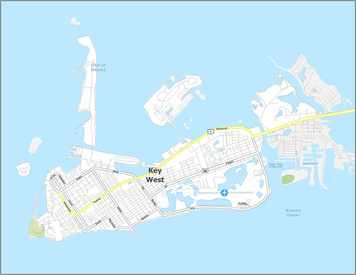
Key West Road Map
Key West is one of the most unique cities in the country and is a great place to visit for families. Our road map can help you explore the best of Florida and beyond with ease. You will get to learn about its highways and major roads so you will never get lost in the city. But if you’re looking to get out of Key West, take a look at our Florida road map for more highway and road information.
US Highways: 1, A1A
Major Roads: 1st St, Atlantic Blvd, Bertha St, Duval St, Eaton St, Palm Ave, Faraldo Cir, Flagler Ave, Front St, Reynolds St, Road 5A, Roosevelt Blvd, South St, Simonton St, Truman Ave, Whitehead St, White St

The city of Key West is a tropical paradise located in the Florida Keys. It is renowned for its beautiful beaches, warm weather, and laid-back atmosphere. The city is filled with old-world charm, and is a popular destination for tourists seeking a tropical getaway. Key West offers a variety of activities, from exploring its harbors, channels, and more, to visiting historical sites like Fort Zachary Taylor Historic State Park.

10 things to do in Key West city
Key West is a charming coastal town with a unique history, beautiful beaches, and plenty of activities to keep you entertained. Whether you are looking for a relaxing getaway or an exciting adventure, there’s something for everyone in Key West! For those planning a trip, our recommended list of attractions will help you find the best places to visit.
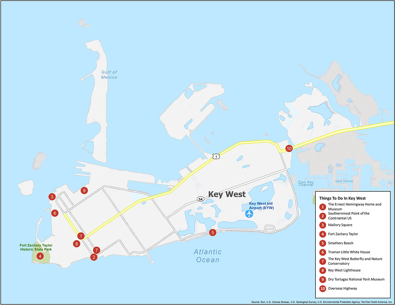
Explore the Best of Key West
Key West is home to a number of world-class attractions, including the Ernest Hemingway Home and Museum, Southernmost Point of the Continental US, Mallory Square, and Fort Zachary Taylor. Visitors can also enjoy the stunning sunsets, white sand beaches, and the Key West Butterfly and Nature Conservatory. Other must-sees include the Truman Little White House, the Key West Lighthouse, Dry Tortugas National Park Museum, and the Overseas Highway.
No matter what type of vacation you are looking for, Key West has something for everyone. From its unique history to its diverse attractions, Key West is the perfect destination for an unforgettable getaway. Our recommended list of attractions will help you find the best places to visit.
Key West city Satellite Map

See also
Map of Florida State and its subdivision:- Alachua
- Baker
- Bay
- Bradford
- Brevard
- Broward
- Calhoun
- Charlotte
- Citrus
- Clay
- Collier
- Columbia
- Desoto
- Dixie
- Duval
- Escambia
- Flagler
- Franklin
- Gadsden
- Gilchrist
- Glades
- Gulf
- Hamilton
- Hardee
- Hendry
- Hernando
- Highlands
- Hillsborough
- Holmes
- Indian River
- Jackson
- Jefferson
- Lafayette
- Lake
- Lee
- Leon
- Levy
- Liberty
- Madison
- Manatee
- Marion
- Martin
- Miami-Dade
- Monroe
- Nassau
- Okaloosa
- Okeechobee
- Orange
- Osceola
- Palm Beach
- Pasco
- Pinellas
- Polk
- Putnam
- Saint Johns
- Saint Lucie
- Santa Rosa
- Sarasota
- Seminole
- Sumter
- Suwannee
- Taylor
- Union
- Volusia
- Wakulla
- Walton
- Washington
- Alabama
- Alaska
- Arizona
- Arkansas
- California
- Colorado
- Connecticut
- Delaware
- District of Columbia
- Florida
- Georgia
- Hawaii
- Idaho
- Illinois
- Indiana
- Iowa
- Kansas
- Kentucky
- Louisiana
- Maine
- Maryland
- Massachusetts
- Michigan
- Minnesota
- Mississippi
- Missouri
- Montana
- Nebraska
- Nevada
- New Hampshire
- New Jersey
- New Mexico
- New York
- North Carolina
- North Dakota
- Ohio
- Oklahoma
- Oregon
- Pennsylvania
- Rhode Island
- South Carolina
- South Dakota
- Tennessee
- Texas
- Utah
- Vermont
- Virginia
- Washington
- West Virginia
- Wisconsin
- Wyoming