Arden-Arcade is a census-designated place (CDP) in Sacramento County, California, United States. The population was 92,186 at the 2010 census, making it the second most populous census-designated place in California. It is east of the city of Sacramento and west of the community of Carmichael.
Arden-Arcade is a principal locality of the Sacramento–Arden-Arcade–Roseville Metropolitan Statistical Area.
| Name: | Arden-Arcade CDP |
|---|---|
| LSAD Code: | 57 |
| LSAD Description: | CDP (suffix) |
| State: | California |
| County: | Sacramento County |
| Elevation: | 56 ft (17 m) |
| Total Area: | 16.13 sq mi (41.77 km²) |
| Land Area: | 15.90 sq mi (41.18 km²) |
| Water Area: | 0.23 sq mi (0.59 km²) 0.50% |
| Total Population: | 94,659 |
| Population Density: | 5,953.02/sq mi (2,298.43/km²) |
| FIPS code: | 0602553 |
Online Interactive Map
Click on ![]() to view map in "full screen" mode.
to view map in "full screen" mode.
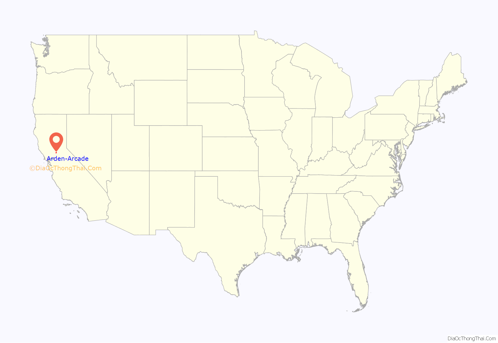
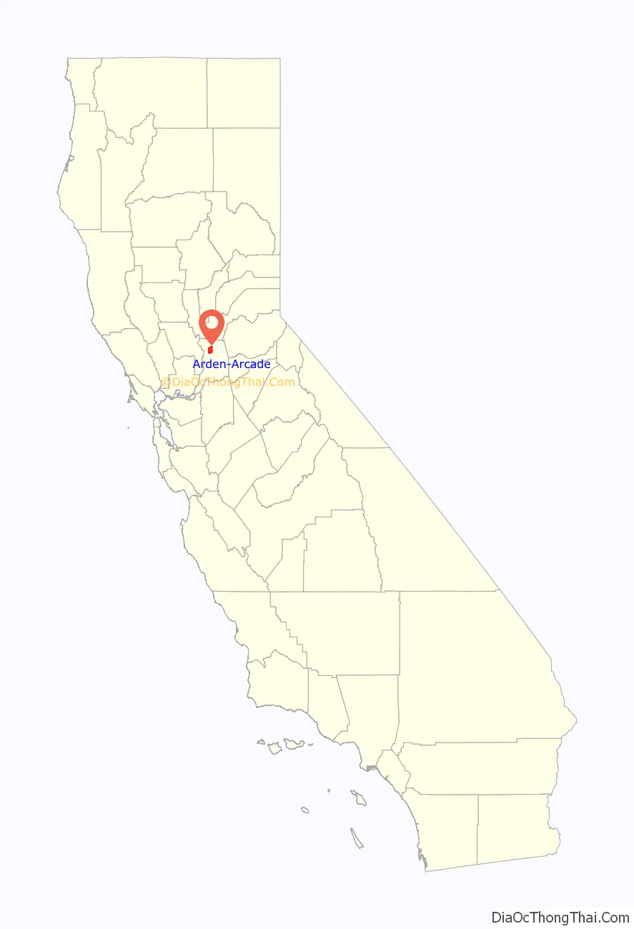
Arden-Arcade location map. Where is Arden-Arcade CDP?
History
The history of the community of Arden-Arcade is documented in the “Sacramento ALC Historical Study 82,” Rancho Del Paso, Office of History, Sacramento Air Logistics Center, McClellan Air Force Base, California, March 1983, by Raymond Oliver. The first residents of what would become the Arden-Arcade area were the Nisenan, an indigenous people of the horizon period with their own language, culture, and social order.
The land was originally part of a Mexican land grant deeded to John Sutter, the Rancho del Paso grant was negotiated from the Mexican governor by Sutter. On August 10, 1843 Sutter then deeded the Rancho Del Paso to Eliab and Hiram Grimes and John Sinclair. Samuel Norris was the next owner of Rancho del Paso, then James Haggin. From 1862 to 1905, James Ben Ali Haggin owned the Rancho, where he became known for breeding race horses. One of the horses bred on the Rancho, Ben Ali, won the 12th Kentucky Derby in world record time 1886. To ship his horses, Haggin built a railroad spur from his northern paddocks (approximately where today’s Hagginwood Golf Course is) toward the current Union Pacific railroad tracks, northeast of the present-day Capitol City Freeway along the beginnings of Arcade Boulevard. On that site, Haggin’s staff built 24 barns with 64 stalls each plus some out buildings. It was there that he would ship his horses mostly to Kentucky, some eventually shipping around the world.
“Arden” most likely comes from the fact that Orlando Robertson, the owner of the Rancho and a developer after Haggin, was originally from Arden Hills, Minnesota. As for “Arcade,” Haggin had located the headquarters alongside the major creek that ran through the Rancho (now off Arcade Boulevard, in the South Hagginwood neighborhood of Northern Sacramento), the place name for which being designated “Arcade,” after the “arcade” of the limbs to a string of shade-giving native oak trees there. The remnants of the majestic trees can still be seen though some are dead stumps. (In architecture, an arcade is a number of arches supporting a wall.)
Orlando Robertson was a land speculator who came to Sacramento after he heard about the exceptional lands of the Rancho Del Paso. He bought the Rancho in 1905 for $1.5 million for his Sacramento Colonization Company and laid out the streets and developed the tracts for sale. Robertson chose street names that reflected the inventors of the period: Watt, Edison, Howe, Bell and so on.
By 1916, given the fertile soil and excellent supply of water, Robertson sold the tracts to farming families, many of them Scandinavian immigrants newly off the boat Scandinavian. In fact, the area around Gibbons Park was known as “Little Norway” because so many Norwegian families settled there. Arden-Arcade and neighboring Carmichael were advertised as excellent areas for growing citrus, but olives, nuts and stone fruit were also farmed here. At one time, Arden-Arcade was the hop-growing region of the world.
Among the oldest surviving buildings in the area are the Arden Middle School, built in 1914, and the Del Paso Country Club, from 1919, named for the original Rancho on which it was built. The first residential neighborhoods in the area were constructed in the 1920s and the 1930s, as the city developed over the river, but the real building boom came at the end of World War II.
However, the real current face of Arden-Arcade was built between 1945 and 1970 and remains a fine representation of a middle-class mid-century modern community, with home developments by John Davis, Jere Strizek, and Randolph Parks. There are also large custom-built developments dotted with homes and office complexes built by Carter Sparks, the Streng Brothers and John Harvey Carter. Arden-Arcade features multiple googie architectural structures as well.
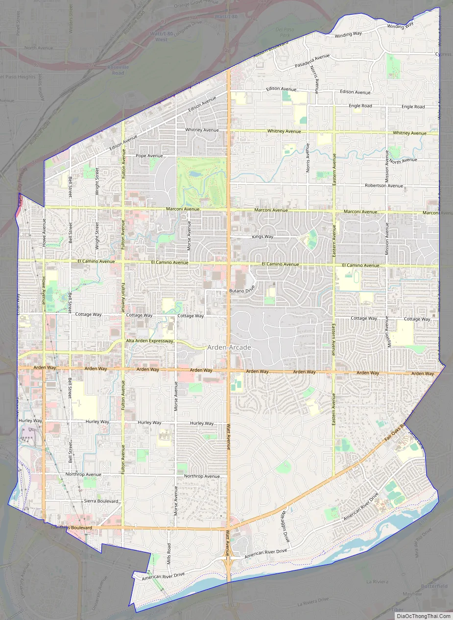
Arden-Arcade Road Map
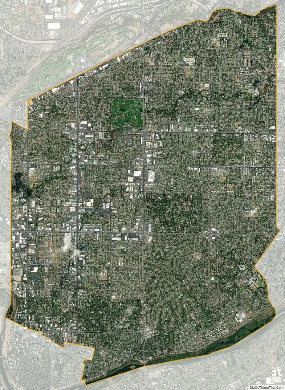
Arden-Arcade city Satellite Map
Geography
Arden-Arcade is located at 38°36′19″N 121°22′47″W / 38.60528°N 121.37972°W / 38.60528; -121.37972 (38.605154, -121.379750).
According to the United States Census Bureau, the CDP has a total area of 17.9 square miles (46 km), of which 17.8 square miles (46 km) of it is land and 0.1 square miles (0.26 km) of it (0.50%) is water.
Boundaries
Arden-Arcade’s northern border is formed by Auburn Boulevard and Arcade Creek, its southern border is primarily the American River, its western border is Ethan Way and its eastern border is formed by Walnut Avenue, Cypress Avenue, and Mission Avenue.
See also
Map of California State and its subdivision:- Alameda
- Alpine
- Amador
- Butte
- Calaveras
- Colusa
- Contra Costa
- Del Norte
- El Dorado
- Fresno
- Glenn
- Humboldt
- Imperial
- Inyo
- Kern
- Kings
- Lake
- Lassen
- Los Angeles
- Madera
- Marin
- Mariposa
- Mendocino
- Merced
- Modoc
- Mono
- Monterey
- Napa
- Nevada
- Orange
- Placer
- Plumas
- Riverside
- Sacramento
- San Benito
- San Bernardino
- San Diego
- San Francisco
- San Joaquin
- San Luis Obispo
- San Mateo
- Santa Barbara
- Santa Clara
- Santa Cruz
- Shasta
- Sierra
- Siskiyou
- Solano
- Sonoma
- Stanislaus
- Sutter
- Tehama
- Trinity
- Tulare
- Tuolumne
- Ventura
- Yolo
- Yuba
- Alabama
- Alaska
- Arizona
- Arkansas
- California
- Colorado
- Connecticut
- Delaware
- District of Columbia
- Florida
- Georgia
- Hawaii
- Idaho
- Illinois
- Indiana
- Iowa
- Kansas
- Kentucky
- Louisiana
- Maine
- Maryland
- Massachusetts
- Michigan
- Minnesota
- Mississippi
- Missouri
- Montana
- Nebraska
- Nevada
- New Hampshire
- New Jersey
- New Mexico
- New York
- North Carolina
- North Dakota
- Ohio
- Oklahoma
- Oregon
- Pennsylvania
- Rhode Island
- South Carolina
- South Dakota
- Tennessee
- Texas
- Utah
- Vermont
- Virginia
- Washington
- West Virginia
- Wisconsin
- Wyoming


