Boulder is a home rule city that is the county seat and most populous municipality of Boulder County, Colorado, United States. The city population was 108,250 at the 2020 United States census, making it the 12th most populous city in Colorado. Boulder is the principal city of the Boulder, CO Metropolitan Statistical Area and an important part of the Front Range Urban Corridor.
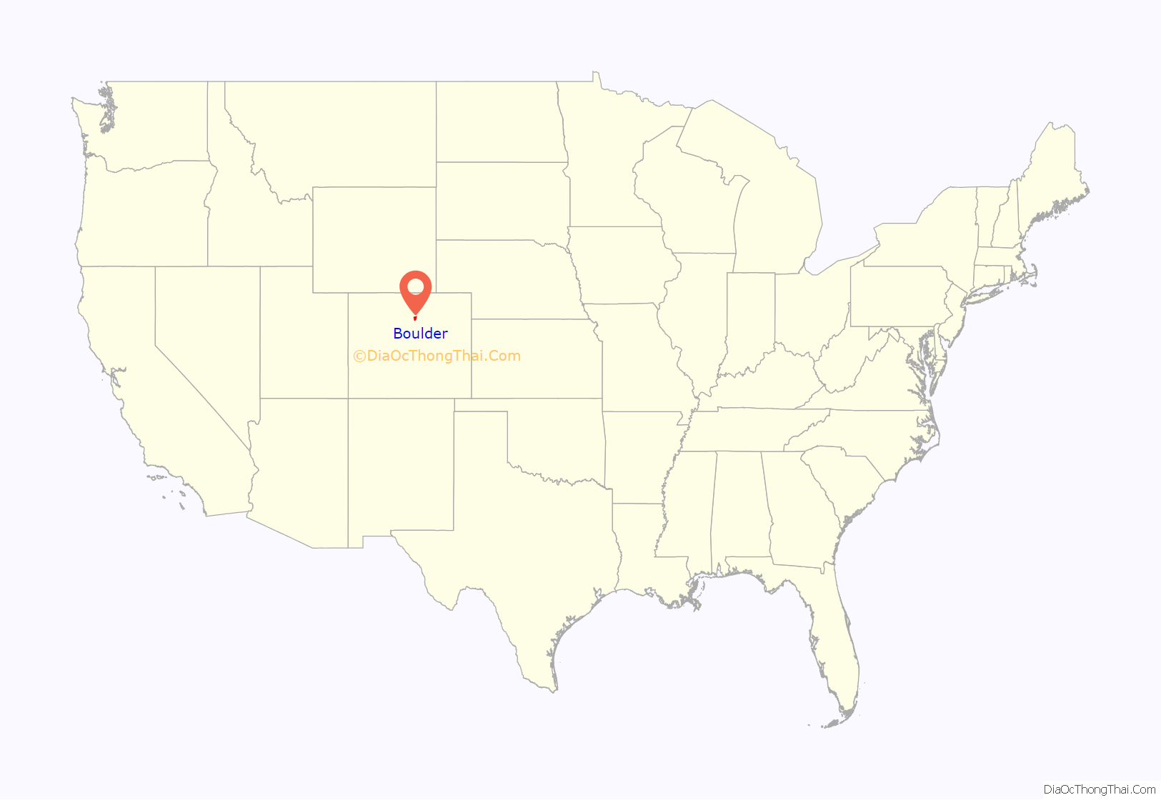
Boulder is located at the base of the foothills of the Rocky Mountains, at an elevation of 5,430 feet (1,655 m) above sea level. Boulder is 25 miles (40 km) northwest of the Colorado state capital of Denver. It is home of the main campus of the University of Colorado, the state’s largest university.
| Name: | Boulder city |
|---|---|
| LSAD Code: | 25 |
| LSAD Description: | city (suffix) |
| State: | Colorado |
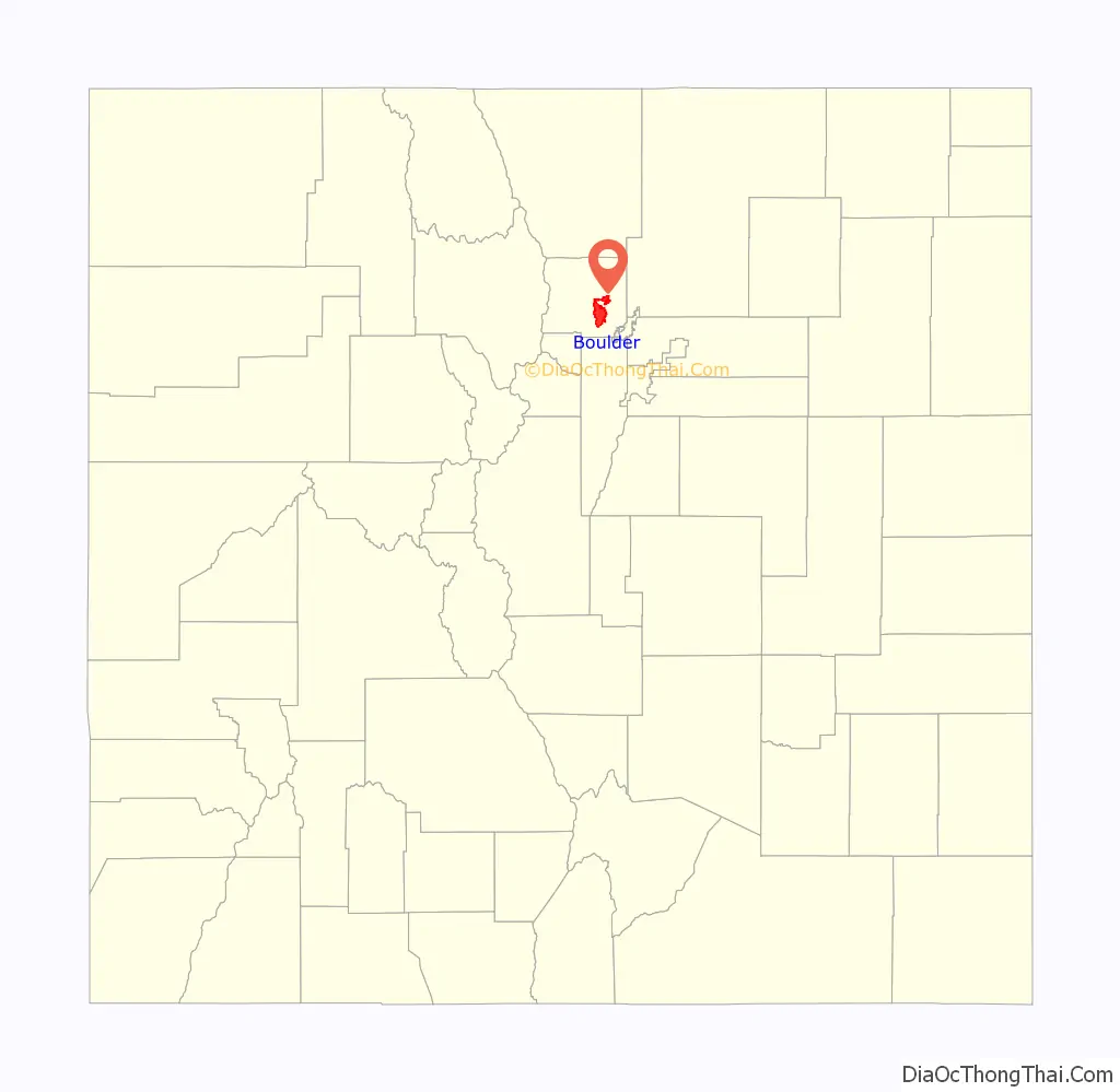
| County: | Boulder County |
| Incorporated: | 1871-11-04 |
| Elevation: | 5,318 ft (1,621 m) |
| Total Area: | 27.366 sq mi (70.877 km²) |
| Land Area: | 26.328 sq mi (68.188 km²) |
| Water Area: | 1.038 sq mi (2.689 km²) |
| Total Population: | 108,250 |
| Population Density: | 4,112/sq mi (1,588/km²) |
| Area code: | Both 303 and 720 |
| FIPS code: | 0807850 |
| GNISfeature ID: | 178680 |
| Website: | bouldercolorado.gov |
If you’re looking to explore this beautiful city, we have the perfect maps for you. Our Boulder Colorado map collection is comprehensive and includes roads/highways, landmarks, and an interactive map. With these maps, you’ll be able to explore the city like a local.
Discover the beauty of Boulder Colorado with our map collection. Our maps feature roads/highways, landmarks, and an interactive map to help you navigate the city like a local. Whether you’re looking for outdoor activities, museums and galleries, or festivals, our Boulder Colorado map collection is a must-have for any avid traveler.
Online Interactive Map
Click on ![]() to view map in "full screen" mode.
to view map in "full screen" mode.
Boulder, Colorado is a great place for outdoor recreation and has plenty of attractions for visitors and locals. The interactive map below will show you the best of Boulder in terms of restaurants, hotels, museums, and more. Zoom in/out, pan around, or click on a marker to get directions and never get lost in the city at the foothills of the Rockies.
Boulder location map. Where is Boulder city?
History
On November 7, 1861, the Colorado General Assembly passed legislation to locate the University of Colorado in Boulder. On September 20, 1875, the first cornerstone was laid for the first building (Old Main) on the CU campus. The university officially opened on September 5, 1877.
In 1907, Boulder adopted an anti-saloon ordinance. Statewide prohibition started in Colorado in 1916 and ended with the repeal of national prohibition in 1933.
Boulder Road Map
Boulder, Colorado is a popular destination for many people. If you’re planning a visit, don’t worry – we have a road map for your trip. With so much to do and see in Boulder, it can be overwhelming for visitors and residents alike. To help you never get lost again, here’s a helpful road map to navigate around the city. Or, if you’re outside the city, print a Colorado map to find your way around the state.
US Highways: 7, 36, 52, 56, 93, 119, 157, Diagonal Hwy, Foothills Hwy
Major Roads: 28th St, Arapahoe Ave, Baseline Rd, Boulder Canyon Dr, Broadway St, Canyon Blvd,
Roads: 4th St, 9th St, 11th St, 15th St, 17th St, 19th St, 20th St, 25th St, 26th St, 30th St, 55th St, 56, 60th St, 63rd St, 6th St, 71st St, 75th St, Airport Rd, Alpine Ave, Arapahoe Rd, Boulder Rd, Cherryvale Rd, Colorado Ave, Darley Ave, Edgewood Dr, Euclid Ave, Folsom St, Forest Ave, Greenbriar Blvd, Iris Ave, Jay Rd, Lehigh St, Lookout Rd, Mineral Rd, Pearl Pky, Pearl St, Regent Dr, Spruce St, Sumac Ave, Table Mesa Dr, University Ave, Valmont Rd, Walnut St
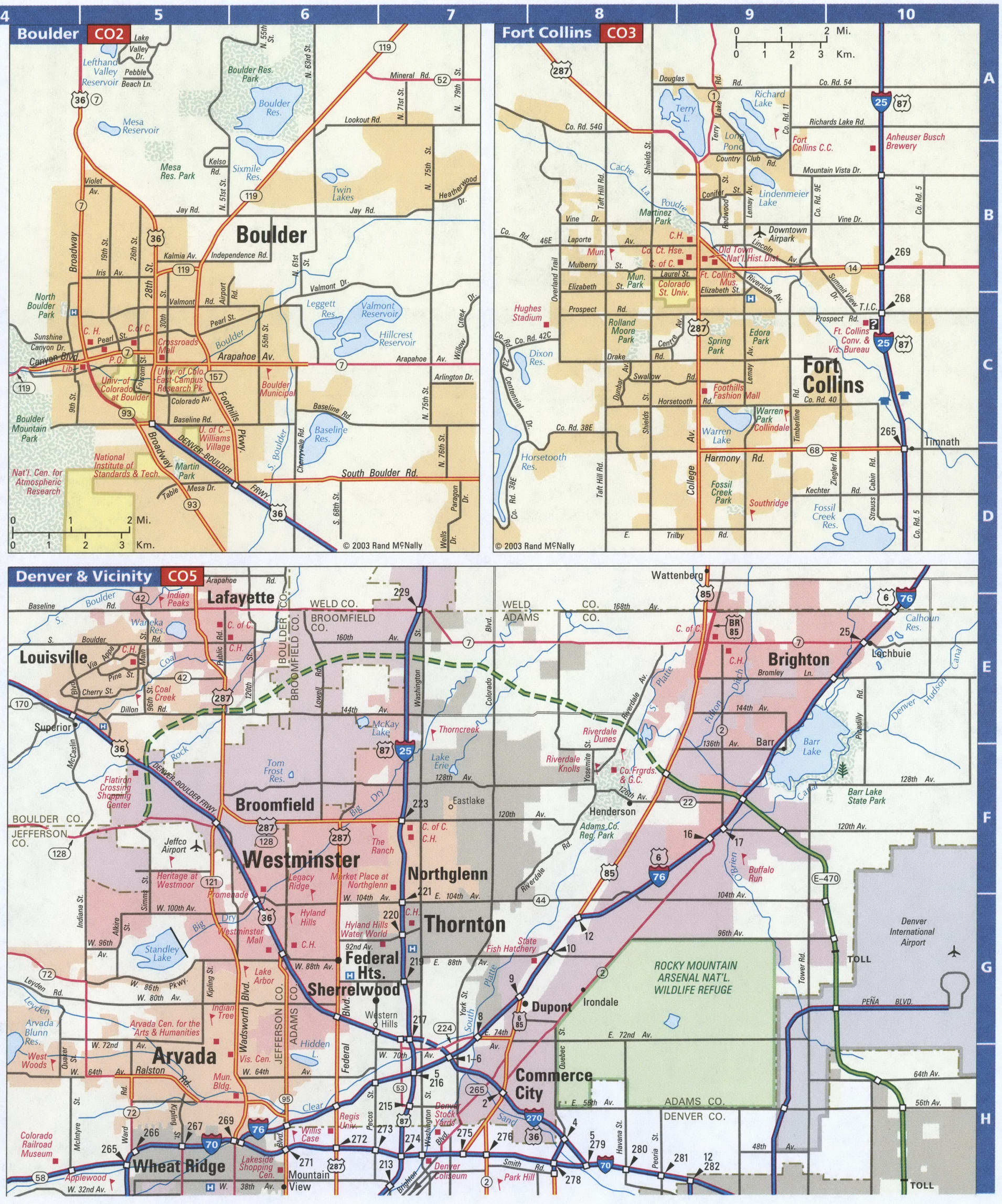
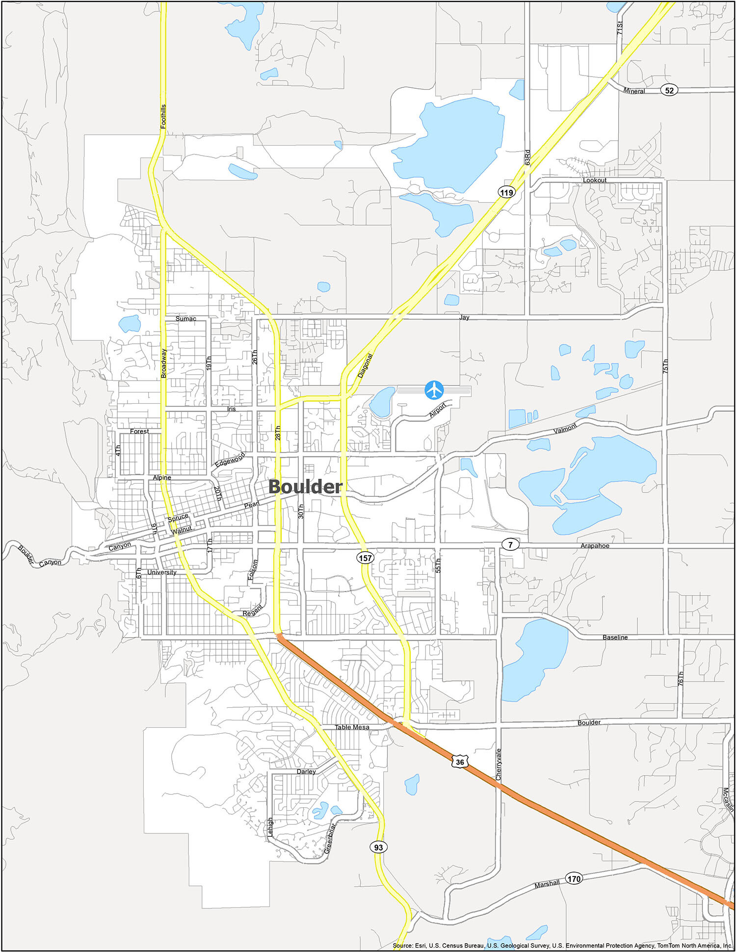
Rivers: Boulder Creek, South Boulder Creek, Left Hand Creek
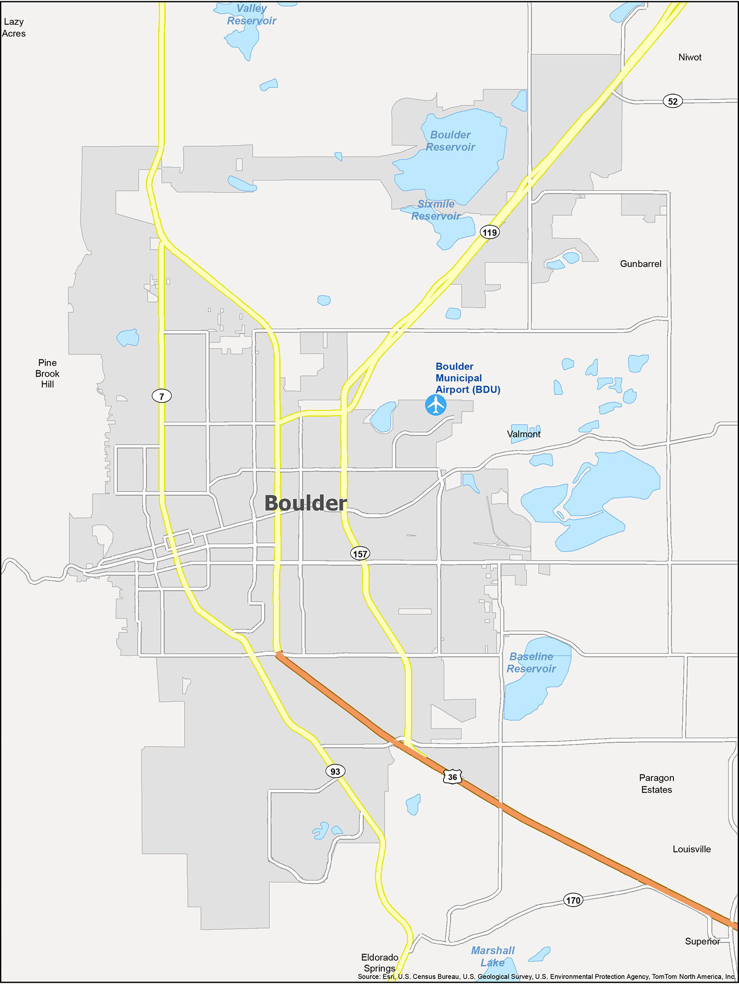
Boulder, Colorado is a great place to escape reality and get away from the hustle and bustle of busy life. With so much to do and see, it is the perfect destination for a weekend getaway or a longer stay. From nature parks to ski resorts, great food, and live music venues, this city has it all. Use this Boulder map to get familiar with the city and its surrounding areas, including nearby airports, rivers, reservoirs, cities, towns, and census-designated places.
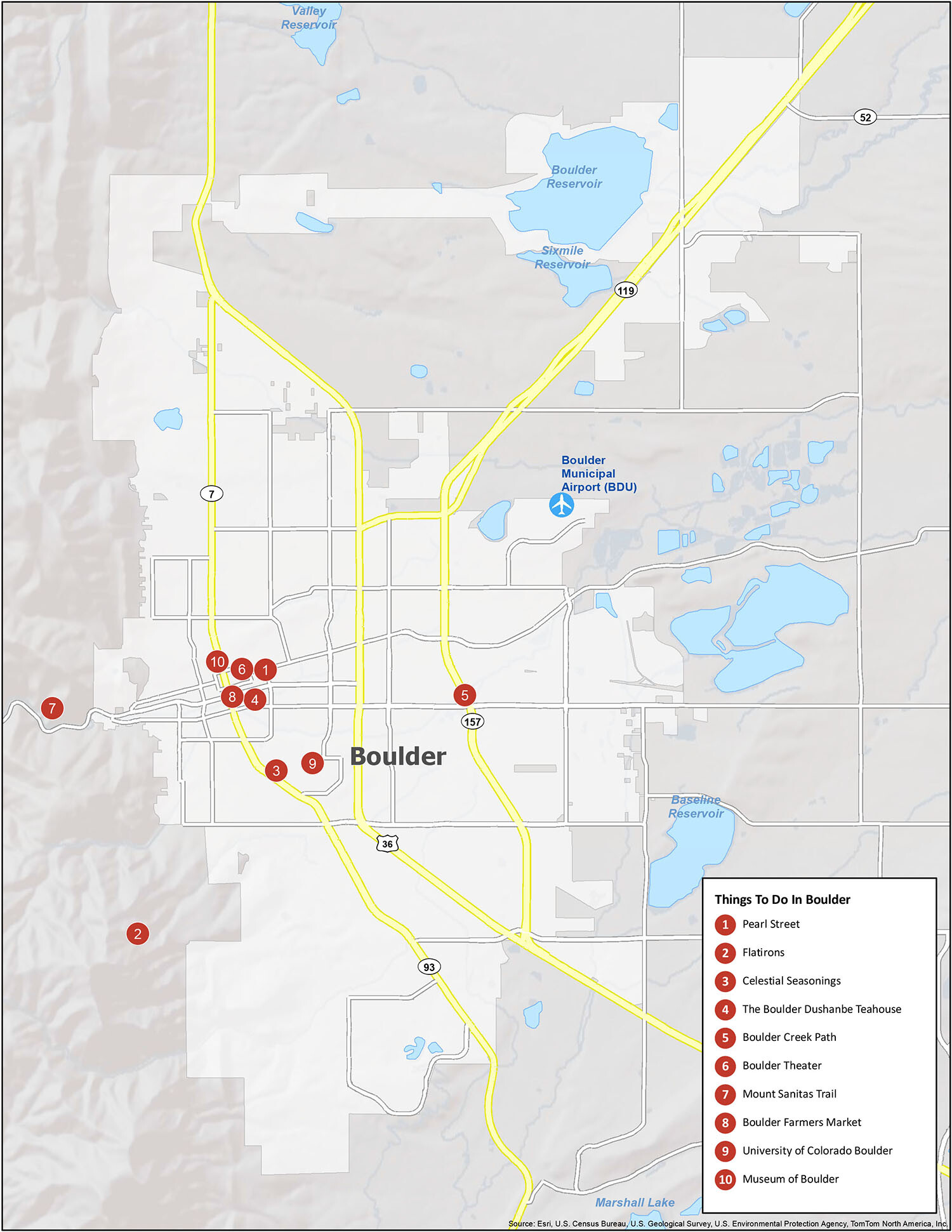
10 things to do in Boulder city
Boulder, Colorado is a vibrant city filled with an abundance of attractions. From outdoor activities like hiking and ziplining to indoor events like concerts and comedy shows, there is something for everyone to enjoy. Popular destinations include the Flatirons, Pearl Street, the Boulder Dushanbe Teahouse, Celestial Seasonings, the Boulder Creek Path, the Boulder Theater, Mount Sanitas Trail, the Boulder Farmers Market, the University of Colorado Boulder, and the Museum of Boulder.
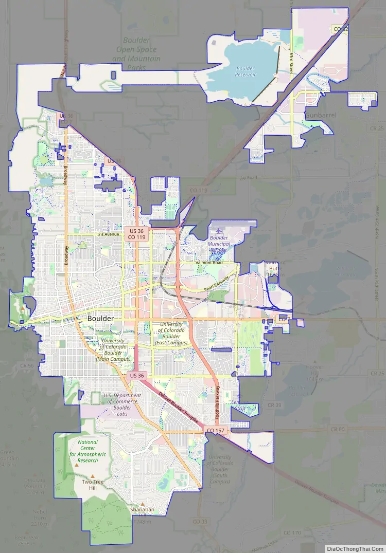
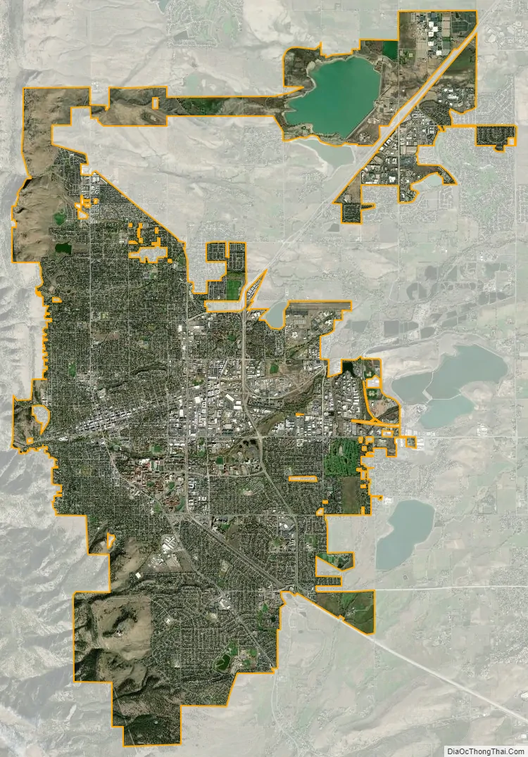
Boulder city Satellite Map
Geography
The city of Boulder is located in the Boulder Valley, where the Rocky Mountains meet the Great Plains. The Flatirons, slabs of sedimentary stone tilted up on the foothills, are located west of the city. The Flatirons are a widely recognized symbol of Boulder.
Boulder Creek is the primary flow of water through Boulder. The creek was named prior to the city’s founding, for all of the large granite boulders that have cascaded into the creek over the eons. It is from Boulder Creek that Boulder city is believed to have taken its name. Boulder Creek has significant water flow, derived primarily from snow melt and minor springs west of the city. The creek is a tributary of the South Platte River.
At the 2020 United States Census, the city had a total area of 17,514 acres (70.877 km) including 664 acres (2.689 km) of water.
The 40th parallel (40 degrees north latitude) runs through Boulder and can be easily recognized as Baseline Road today.
Boulder lies in a wide basin beneath Flagstaff Mountain just a few miles east of the continental divide and about 25 miles (40 km) northwest of Denver. Arapahoe Glacier provides water for the city, along with Boulder Creek, which flows through the center of the city.
Denver International Airport is located 45 miles (72 km) southeast of Boulder.
Growth management
Government preservation of open space around Boulder began with the Congress of the United States approving the allocation of 1,800 acres (7.3 km) of mountain backdrop/watershed extending from South Boulder Creek to Sunshine Canyon in 1899.
Since then, Boulder has adopted a policy of controlled urban expansion. In 1959, city voters approved the “Blue Line” city-charter amendment which restricted city water service to altitudes below 5,750 feet (1,750 m), in an effort to protect the mountain backdrop from development. In 1967, city voters approved a dedicated sales tax for the acquisition of open space in an effort to contain urban sprawl. In 1970, Boulder created a “comprehensive plan” that would dictate future zoning, transportation, and urban planning decisions. Hoping to preserve residents’ views of the mountains, in 1972, the city enacted an ordinance limiting the height of newly constructed buildings. A Historic-Preservation Code was passed in 1974, and a residential-growth management ordinance (the Danish Plan) in 1976.
Effective growth management has resulted in a rapid increase in housing costs with the median home price rising 60% over the period 2010 to 2015 to $648,200.
Boulder has created an Urban Wildlife Management Plan which sets policies for managing and protecting urban wildlife. Also, the city’s Parks and Recreation and Open Space and Mountain Parks departments have volunteers who monitor parks (including wetlands, lakes, etc.) to protect ecosystems. From time to time, parks and hiking trails are closed to conserve or restore ecosystems. Traditionally, Boulder has avoided the use of chemical pesticides for controlling the insect population. However, with the threat of West Nile virus, the city began an integrative plan to control the mosquito population in 2003 that includes chemical pesticides. Residents can opt-out of the program by contacting the city and asking that their areas not be sprayed.
Under Boulder law, extermination of prairie dogs requires a permit.
Also in 2005, the city experimented with using goats for weed control in environmentally sensitive areas. Goats naturally consume diffuse knapweed and Canada thistle, and although the program was not as effective as it was hoped, goats will still be considered in the future weed control projects. In 2010, goats were used to keep weeds under control at the Boulder Reservoir.
The city’s Open Space and Mountain Parks department manages approximately 8,000 acres of protected forest land west of the city in accordance with a 1999 Forest Ecosystem Management Plan. The plan aims to maintain or enhance native plant and animal species, their communities, and the ecological processes that sustain them and to reduce the wildfire risk to forest and human communities.
Climate
Boulder has a temperate climate typical for much of the state and receives many sunny or mostly sunny days each year. Under the Köppen climate classification, the city is considered semi-arid (Köppen BSk) or humid subtropical (Köppen Cfa) as it falls near that precipitation boundary, due to its relatively high yearly precipitation and average temperatures remaining above 32 °F (0 °C) year-round. Winter conditions range from generally mild to the occasional bitterly cold, with highs averaging in the mid to upper 40s °F (7–9 °C). There are 4.6 nights annually during which the temperature reaches 0 °F (−18 °C). Because of orographic lift, the mountains to the west often dry out the air passing over the Front Range, often shielding the city from precipitation in winter, though heavy snowfalls may occur. Snowfall averages 88 inches (220 cm) per season, but snow depth is usually shallow; a strong warming sun due to the high elevation can quickly melt snow cover during the day, and Chinook winds bring rapid warm-ups throughout the winter months. Summers are warm, with frequent afternoon thunderstorms. Roughly 30 days reach 90 °F (32 °C) or above each year. Diurnal temperature variation is typically large due to the high elevation and semi-arid climate. Daytime highs are generally cooler than those of most Colorado cities with similar elevations. However, Boulder’s nighttime lows are mild, particularly during winter. The average January temperature of 34.5 °F (1.4 °C) is the warmest of any city in the state. The highest recorded temperature of 104 °F (40 °C) occurred most recently on June 25, 2012. The record low was −33 °F (−36 °C) on January 17, 1930. The coldest high temperature, −12 °F (−24 °C), was recorded on February 4, 1989, while the warmest overnight low was recorded on July 20, 1998, with a temperature of 82 °F (28 °C)
See also
Map of Colorado State and its subdivision:- Adams
- Alamosa
- Arapahoe
- Archuleta
- Baca
- Bent
- Boulder
- Broomfield
- Chaffee
- Cheyenne
- Clear Creek
- Conejos
- Costilla
- Crowley
- Custer
- Delta
- Denver
- Dolores
- Douglas
- Eagle
- El Paso
- Elbert
- Fremont
- Garfield
- Gilpin
- Grand
- Gunnison
- Hinsdale
- Huerfano
- Jackson
- Jefferson
- Kiowa
- Kit Carson
- La Plata
- Lake
- Larimer
- Las Animas
- Lincoln
- Logan
- Mesa
- Mineral
- Moffat
- Montezuma
- Montrose
- Morgan
- Otero
- Ouray
- Park
- Phillips
- Pitkin
- Prowers
- Pueblo
- Rio Blanco
- Rio Grande
- Routt
- Saguache
- San Juan
- San Miguel
- Sedgwick
- Summit
- Teller
- Washington
- Weld
- Yuma
- Alabama
- Alaska
- Arizona
- Arkansas
- California
- Colorado
- Connecticut
- Delaware
- District of Columbia
- Florida
- Georgia
- Hawaii
- Idaho
- Illinois
- Indiana
- Iowa
- Kansas
- Kentucky
- Louisiana
- Maine
- Maryland
- Massachusetts
- Michigan
- Minnesota
- Mississippi
- Missouri
- Montana
- Nebraska
- Nevada
- New Hampshire
- New Jersey
- New Mexico
- New York
- North Carolina
- North Dakota
- Ohio
- Oklahoma
- Oregon
- Pennsylvania
- Rhode Island
- South Carolina
- South Dakota
- Tennessee
- Texas
- Utah
- Vermont
- Virginia
- Washington
- West Virginia
- Wisconsin
- Wyoming


