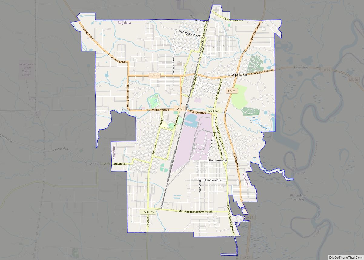
Bogalusa is a city in Washington Parish, Louisiana, United States. The population was 12,232 at the 2010 census. In the 2020 census the city, town, place equivalent reported a population of 10,659. It is the principal city of the Bogalusa Micropolitan Statistical Area, which includes all of Washington Parish and is also part of the larger New Orleans–Metairie–Hammond combined statistical area.
The name of the city derives from the Choctaw language term bogue lusa, which translates into English as “dark water or “smoky water”. Located in an area of pine forests, in the early 20th century, this industrial city was developed as a company town, to provide worker housing and services in association with a Great Southern Lumber Company sawmill. In the late 1930s, this operation was replaced with paper mills and chemical operations.
| Name: | Bogalusa city |
|---|---|
| LSAD Code: | 25 |
| LSAD Description: | city (suffix) |
| State: | Louisiana |
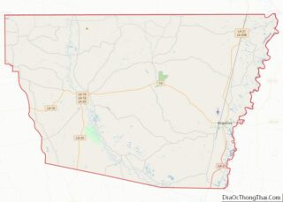
| County: | Washington Parish |
| Incorporated: | July 4, 1914 |
| Elevation: | 95 ft (29 m) |
| Total Area: | 9.55 sq mi (24.74 km²) |
| Land Area: | 9.51 sq mi (24.62 km²) |
| Water Area: | 0.05 sq mi (0.13 km²) |
| Total Population: | 10,659 |
| Population Density: | 1,121.41/sq mi (432.98/km²) |
| Area code: | 985 |
| FIPS code: | 2208150 |
| Website: | http://www.bogalusa.org |
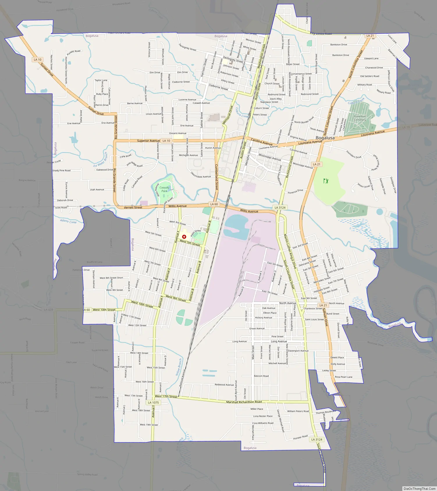
Online Interactive Map
Click on ![]() to view map in "full screen" mode.
to view map in "full screen" mode.
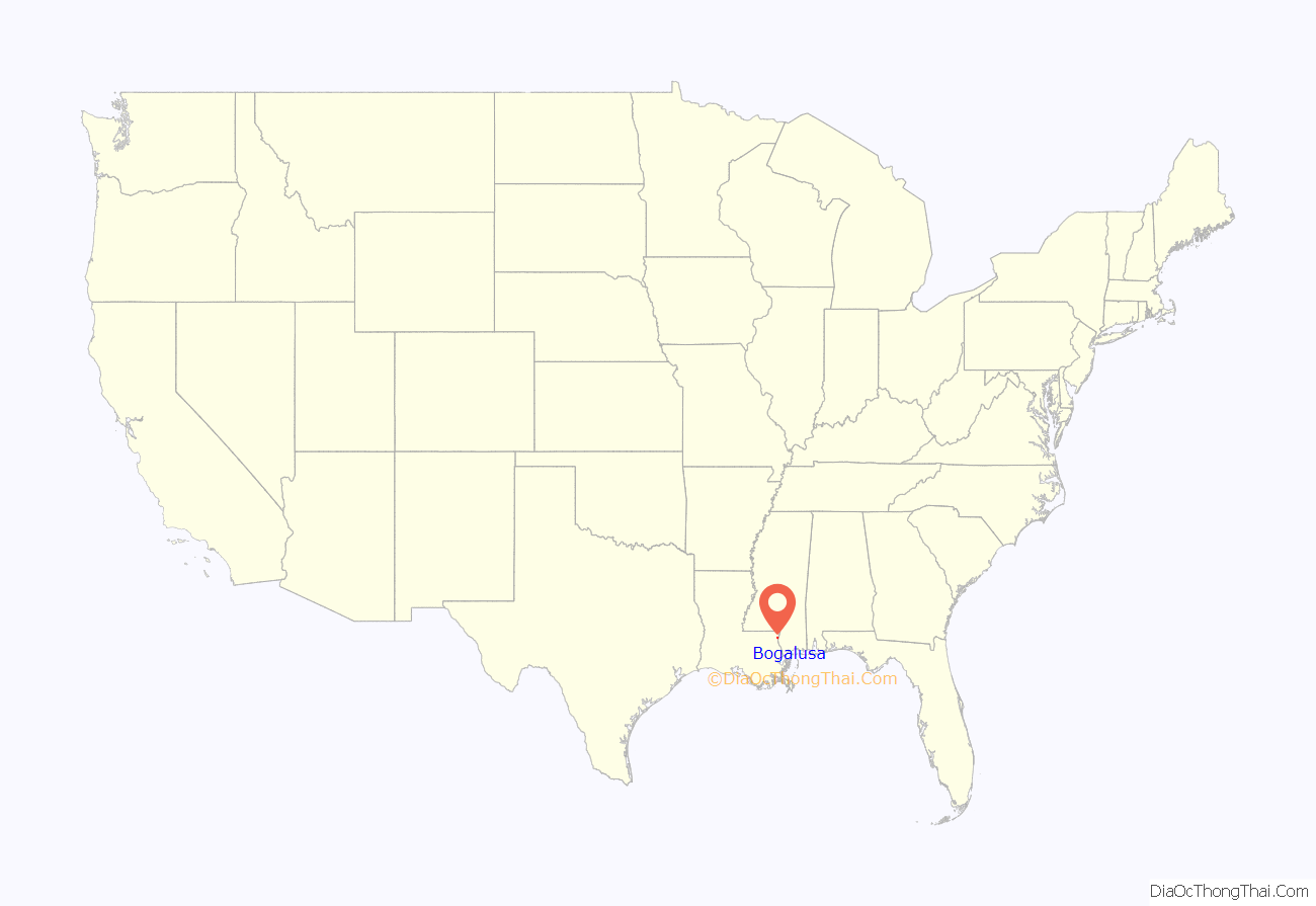
Bogalusa location map. Where is Bogalusa city?

History
Founding
Incorporated in 1914, Bogalusa is one of the youngest towns in Louisiana. It was founded by Frank Henry Goodyear and Charles Waterhouse Goodyear, lumber barons of Buffalo, New York. In the early 1900s, the brothers bought hundreds of thousands of acres of virgin Longleaf pine forests in southeastern Louisiana and southwestern Mississippi for the timber and further their strategy to build railroad spurs to bring the wood to market. In 1902, they chartered the Great Southern Lumber Company (1908–38) and built the first sawmill in what became Bogalusa, a company town built to support the mill. The sawmill was the largest in the world at the time. The Goodyear interests built the city of Bogalusa to house workers and supervisors, and associated infrastructure. They also built the Great Northern New Orleans Railroad to New Orleans to transport their lumber and products to market.
The city, designed by architect Rathbone DeBuys of New Orleans and built from the ground up in less than a year, had several hotels, schools, a hospital, a YMCA and YWCA, churches of all faiths, and houses for the mill workers. The town was laid out with the “Mill Town” on the south side and “Commercial Town” on the north side, altogether there were four quadrants with racially segregated neighborhoods defined by the railroad running north–south and Bogue Lusa Creek running east–west. It was called the “Magic City” in praise of its rapid construction. The manager of Great Southern Lumber Company was William H. Sullivan. As sawmill manager, he acted as town boss when the city was built. After Bogalusa was incorporated as a city on July 4, 1914, Sullivan was elected as mayor by white voters (blacks had been disenfranchised), and repeatedly re-elected, serving until his death on June 26, 1929.
The Great Southern Lumber Company’s sprawling sawmill produced up to a million board feet (2400 m) of lumber each day. With the virgin pine forest cleared, the sawmill closed in 1938 during the Great Depression. An attempt to keep the sawmill open with California redwood proved too costly, and the mill was closed. It was replaced by the Bogalusa Paper Company (a subsidiary of Great Southern). In 1937 Bogalusa Paper Company merged with Gaylord Container Corporation; a chemical plant also run by Gaylord was built next to the mill. Crown-Zellerbach acquired Gaylord’s operations in 1955. The paper mill and chemical operations continued to anchor the city’s economy.
At its peak in 1960, the city had more than 21,000 residents. In 1985 Crown-Zellerbach was split up but the timber industry continued.
Racial conflicts
In 1919 workers went on strike, triggering the largest labor strife at the town’s Great Southern Lumber Company, the largest sawmill in the world. Company owners supported a white militia group and brought in Black strikebreakers, increasing racial tension. Events culminated in the Bogalusa sawmill killings which saw four union men killed. On August 31, 1919, Black veteran Lucius McCarty was accused of assaulting a white woman and a mob of some 1,500 people seized McCarty and shot him more than 1,000 times. The mob then dragged his corpse behind a car through the black neighborhoods before burning his body in a bonfire.
Civil rights era
Both black and white industrial workers had come to the company town for work since the early 20th century. After World War II and service for their country, African-American veterans struggled in Louisiana and the South against the oppression of Jim Crow laws, state segregation, and disenfranchisement and exclusion from the political system, all continuing since the turn of the 20th century.
During the civil rights era, black workers pressed Crown-Zellerbach to open all positions to them, promote them to supervisory positions, and otherwise give them equal opportunities at work. White workers resisted these changes. Similarly, blacks pressured the city of Bogalusa to integrate public facilities, especially after passage of the Civil Rights Law of 1964.
In Bogalusa, black workers also struggled against the industrial class system. As their activism increased in the civil rights era, whites resisted. Local Ku Klux Klan members dominated the region, attacking and intimidating civil rights activists in the 1960s. In 1964, as civil rights activists continued to push for their constitutional rights after congressional passage that year of the Civil Rights Act that year, whites increased their resistance.
Determined to fight for their rights, Bob Hicks, Charles Sims, A.Z. Young, and others had taken leadership of the (all-black) Bogalusa Civic and Voters’ League. On February 21, 1965, with the help of three activists from the Deacons for Defense and Justice based in Jonesboro, Louisiana, they founded the first affiliated chapter of that African-American self-defense organization. Other leaders of the Deacons were Bert Wyre, Aurilus “Reeves” Perkins, Sam Bonds, Fletcher Anderson, and others. They mobilized many war veterans within the black community to provide armed security to civil rights activists and their families. Expecting a violent summer, the State Police established an office in Bogalusa in February 1965.
As explained by Seth Hague,
Two unsolved murders of African Americans took place in Bogalusa during the civil rights era: killed in 1965 was Oneal Moore, the first black deputy sheriff hired for the Washington Parish Sheriff’s Office, and in 1966 Clarence Triggs was killed.
1970 to present
With changes in the lumber industry, through the late 20th century, after 1960, a steady decline in industrial operations, jobs, and associated population of the town occurred. By 2015, the population was estimated at slightly less than 12,000, more than 40% below the high in 1960. These conditions have made it more difficult for remaining residents.
In 1995, a railroad tank car imploded at Gaylord Chemical Corporation, releasing nitrogen tetroxide and forcing the evacuation of about 3,000 people within a one-mile (1.6 km) radius. Residents say “the sky turned orange” as a result. Emergency rooms filled with about 4,000 people who complained of burning eyes, skin, and lungs. Dozens of lawsuits were filed against Gaylord Chemical and were finally settled in May 2005, with compensation checks issued to around 20,000 people affected by the accident.
On August 29, 2005, Hurricane Katrina hit the city with winds of about 110 mph (175 km/h), downing numerous trees and power lines. Many buildings in Bogalusa were damaged from falling trees, and several were destroyed. Most of the houses, businesses, and other buildings suffered roof damage from the storm’s ferocious winds. Some outlying areas of the city were without power for more than a month.
Bogalusa Road Map
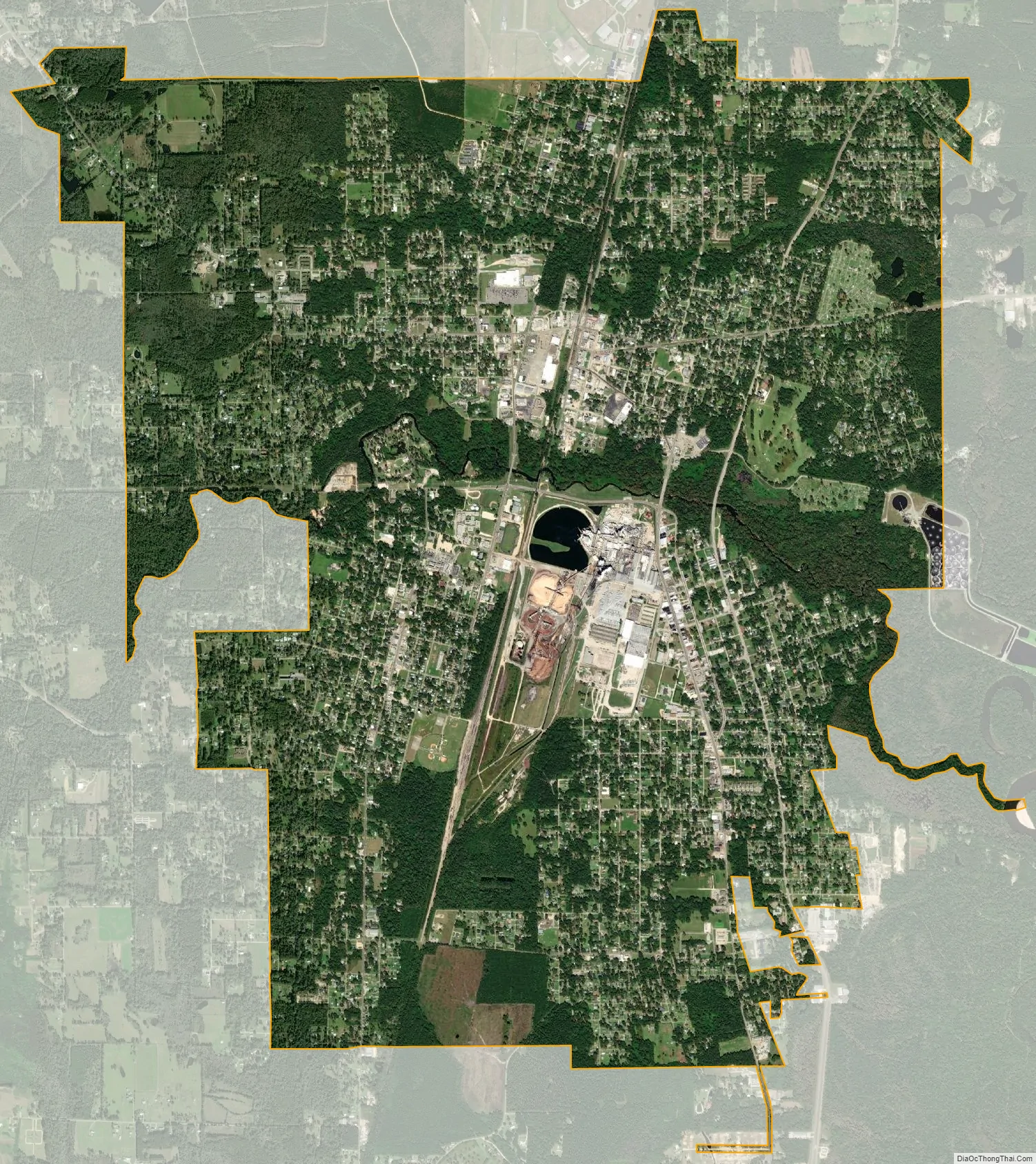
Bogalusa city Satellite Map
Geography
Bogalusa has an elevation of 100 feet (30.5 m).
According to the United States Census Bureau, the city has a total area of 9.5 square miles (24.6 km), of which 9.5 square miles (24.6 km) is land and 0.1 square miles (0.3 km) (0.52%) is covered by water.
See also
Map of Louisiana State and its subdivision:- Acadia
- Allen
- Ascension
- Assumption
- Avoyelles
- Beauregard
- Bienville
- Bossier
- Caddo
- Calcasieu
- Caldwell
- Cameron
- Catahoula
- Claiborne
- Concordia
- De Soto
- East Baton Rouge
- East Carroll
- East Feliciana
- Evangeline
- Franklin
- Grant
- Iberia
- Iberville
- Jackson
- Jefferson
- Jefferson Davis
- La Salle
- Lafayette
- Lafourche
- Lincoln
- Livingston
- Madison
- Morehouse
- Natchitoches
- Orleans
- Ouachita
- Plaquemines
- Pointe Coupee
- Rapides
- Red River
- Richland
- Sabine
- Saint Bernard
- Saint Charles
- Saint Helena
- Saint James
- Saint John the Baptist
- Saint Landry
- Saint Martin
- Saint Mary
- Saint Tammany
- Tangipahoa
- Tensas
- Terrebonne
- Union
- Vermilion
- Vernon
- Washington
- Webster
- West Baton Rouge
- West Carroll
- West Feliciana
- Winn
- Alabama
- Alaska
- Arizona
- Arkansas
- California
- Colorado
- Connecticut
- Delaware
- District of Columbia
- Florida
- Georgia
- Hawaii
- Idaho
- Illinois
- Indiana
- Iowa
- Kansas
- Kentucky
- Louisiana
- Maine
- Maryland
- Massachusetts
- Michigan
- Minnesota
- Mississippi
- Missouri
- Montana
- Nebraska
- Nevada
- New Hampshire
- New Jersey
- New Mexico
- New York
- North Carolina
- North Dakota
- Ohio
- Oklahoma
- Oregon
- Pennsylvania
- Rhode Island
- South Carolina
- South Dakota
- Tennessee
- Texas
- Utah
- Vermont
- Virginia
- Washington
- West Virginia
- Wisconsin
- Wyoming