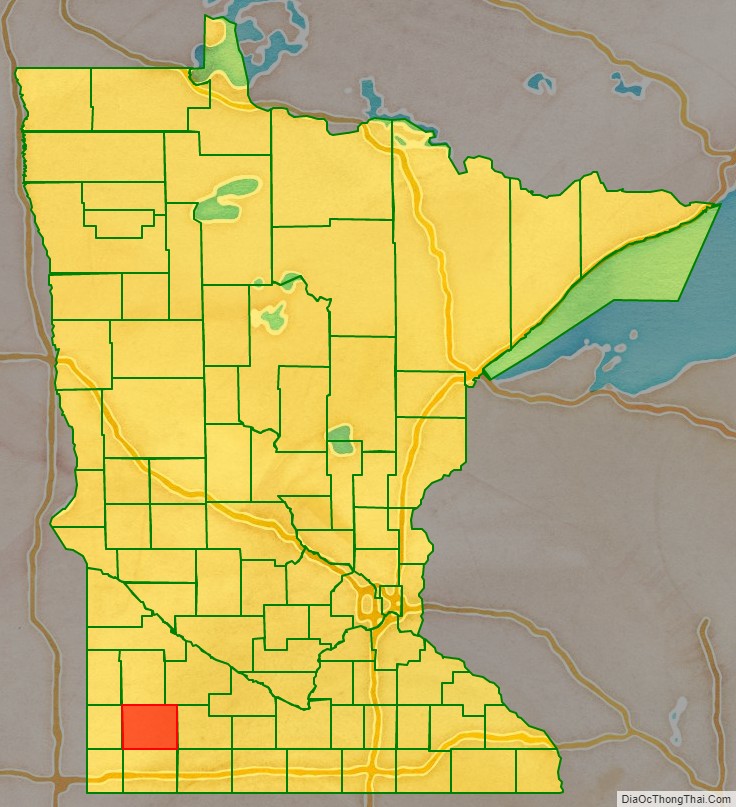
Murray County is a county in the U.S. state of Minnesota. The population was 8,179 at the 2020 census. Its county seat is Slayton.
| Name: | Murray County |
|---|---|
| FIPS code: | 27-101 |
| State: | Minnesota |
| Founded: | 1857 |
| Named for: | William Pitt Murray |
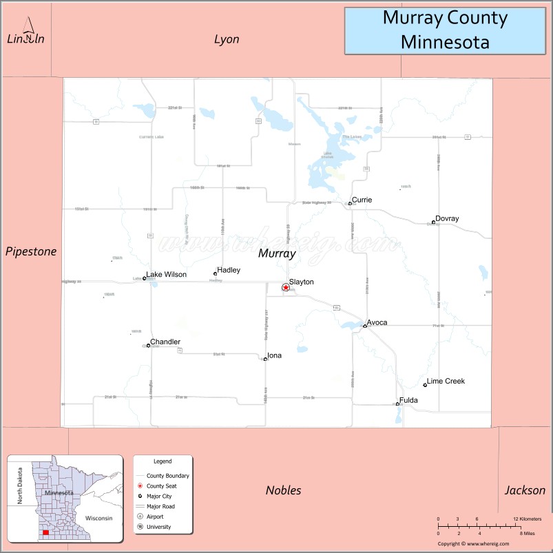
| Seat: | Slayton |
| Largest city: | Slayton |
| Total Area: | 720 sq mi (1,900 km²) |
| Land Area: | 705 sq mi (1,830 km²) |
| Total Population: | 8,179 |
| Population Density: | 11.6/sq mi (4.5/km²) |
| Time zone: | UTC−6 (Central) |
| Summer Time Zone (DST): | UTC−5 (CDT) |
| Website: | www.murray-countymn.com |
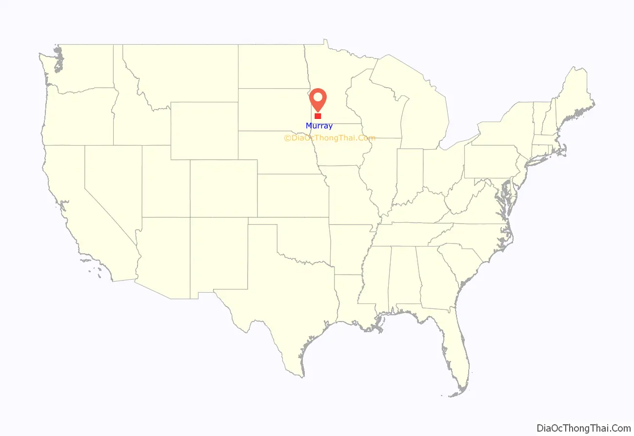
Murray County location map. Where is Murray County?
History
In 1853 the Minnesota Territory legislature created Blue Earth County from unorganized Dakota Territory lands. In 1855 the legislature partitioned a portion of western Blue Earth to create Brown County. Then on May 23, 1857, a portion of Brown was partitioned off to create Murray County, although it was not organized at that time. On June 17, 1872, the county government was effected, with Currie, which had been founded that same year, as county seat. The county was named for William Pitt Murray (1825-1910), a prominent civic and political figure in Minnesota during its nascent era.
Also in 1872 the township of Center was platted (so named for its central position in the county). This settlement grew rapidly, and its residents soon began agitating to have the county seat moved there. In 1882 the town was renamed as Slayton, and a county vote changed the county seat to Slayton effective June 1, 1889.
In the history of record keeping, Minnesota has been struck by two F-5 tornadoes, and both occurred in Murray County: the Chandler-Lake Wilson Tornado (June 16, 1992) and the Tracy Tornado (June 13, 1968) that began in Murray County before crossing north into Lyon County.
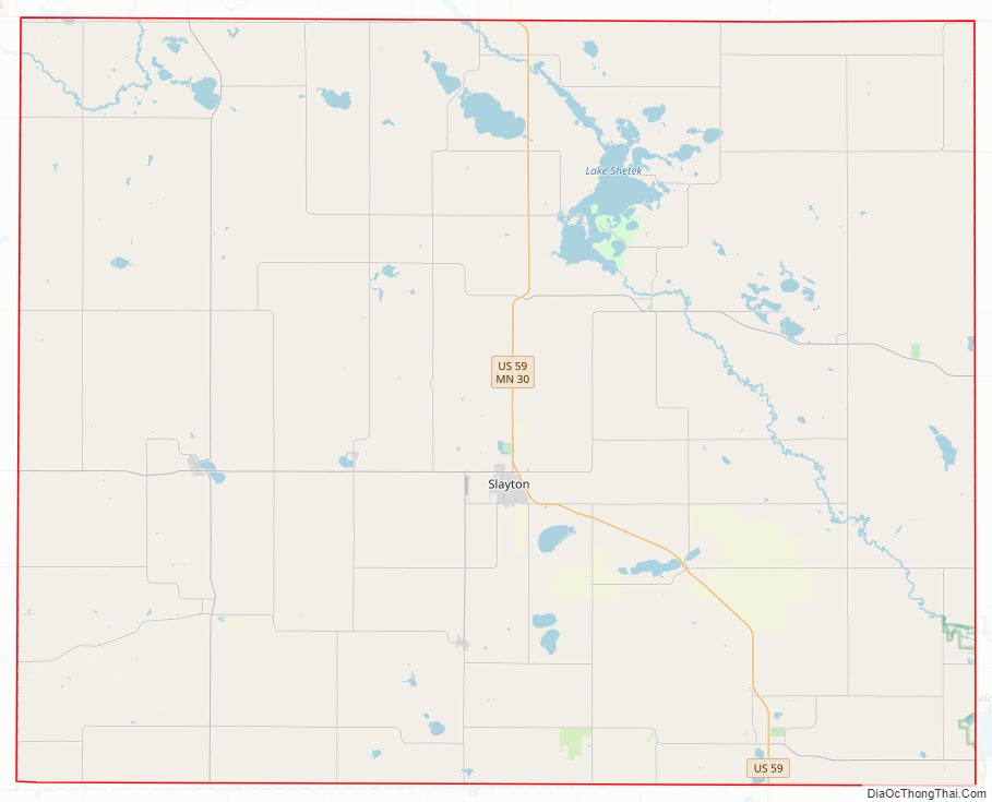
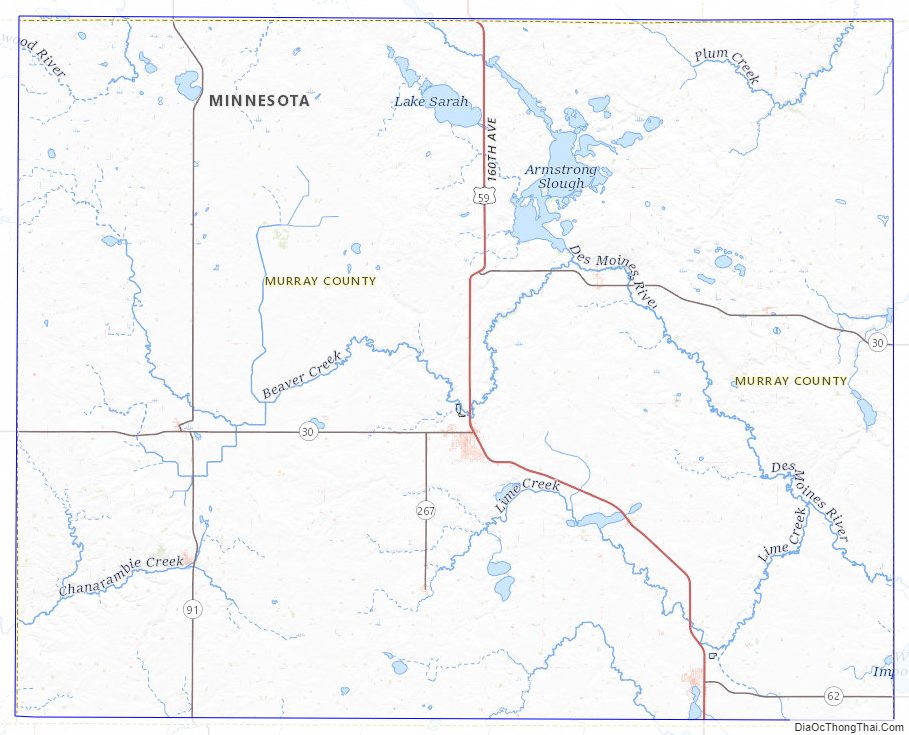
Murray County Road Map
Geography
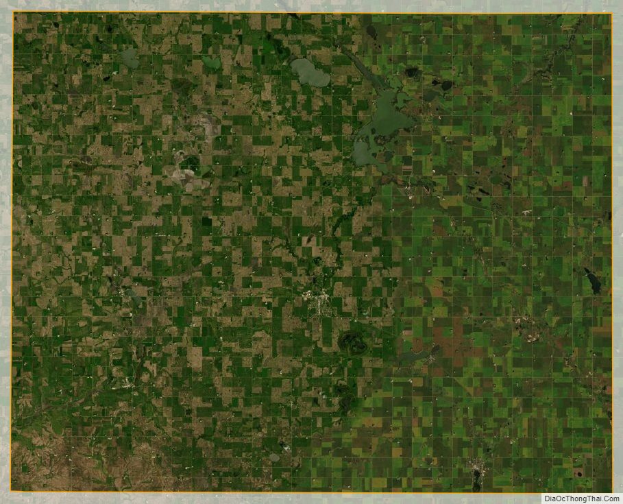
The county terrain consists of low rolling hills, dotted with lakes and ponds, with all available area devoted to agriculture. The terrain slopes to the south and east. However, its highest elevation occurs on Buffalo Ridge, a promontory extending about two miles along the crest of the Coteau des Prairies in central Chanarambie Township. The bluff rises a few hundred feet above the adjacent valleys. The county has a total area of 720 square miles (1,900 km), of which 705 square miles (1,830 km) is land and 15 square miles (39 km) (2.1%) is water.
The Mississippi-Missouri watershed divide runs through the western part of the county, near Chandler, along Buffalo Ridge. The county’s highest point is on that ridge, at 1,920′ ASL.
Major highways
- U.S. Highway 59
- Minnesota State Highway 30
- Minnesota State Highway 62
- Minnesota State Highway 91
- Minnesota State Highway 267
Airports
- Slayton Municipal Airport (DVP) – southwest of Slayton, Minnesota
Adjacent counties
- Lyon County – north
- Redwood County – northeast
- Cottonwood County – east
- Nobles County – south
- Rock County – southwest
- Pipestone County – west
Protected areas
- Badger Lake State Wildlife Management Area
- Bergman State Wildlife Management Area
- Big Slough State Wildlife Management Area
- Buffalo Lake State Wildlife Management Area
- Chandler State Wildlife Management Area
- County Line State Wildlife Management Area
- Current Lake State Wildlife Management Area
- Great Oasis State Wildlife Management Area
- Haberman State Wildlife Management Area
- Hjermstad Lake State Wildlife Management Area
- Irruption State Wildlife Management Area
- Klinker State Wildlife Management Area
- Lake Shetek State Park
- Lange State Wildlife Management Area
- Leeds State Wildlife Management Area
- Lowville State Wildlife Management Area
- Mason State Wildlife Management Area
- McCord-Laible State Wildlife Management Area
- Nelson State Wildlife Management Area
- Northern Tallgrass Prairie National Wildlife Refuge
- Peters State Wildlife Management Area
- Phelan State Wildlife Management Area
- Reinhold State Wildlife Management Area
- Rupp State Wildlife Management Area
- Ruthton State Wildlife Management Area
- Schoeberl State Wildlife Management Area
- Shetek State Wildlife Management Area
- Sweetman State Wildlife Management Area
- Tutt State Wildlife Management Area
- Van Eck State Wildlife Management Area
Lakes
- Bear Lake (drained)
- Bloody Lake
- Buffalo Lake
- Corabelle Lake
- Current Lake
- Fox Lake
- Fulda First Lake
- Iron Lake
- Julia Lake (part)
- Lake Louisa
- Lake Maria
- Lake Sarah
- Lake Shetek
- Lake Wilson
- Lime Lake (formerly known as Lizzard Lake and Lake St. Rose)
- Long Lake (part)
- North Badger Lake
- Round Lake
- Smith Lake
- South Badger Lake
- Summit Lake
- Talcot Lake (part)
Murray County Topographic Map
Murray County Satellite Map
Murray County Outline Map

See also
Map of Minnesota State and its subdivision:- Aitkin
- Anoka
- Becker
- Beltrami
- Benton
- Big Stone
- Blue Earth
- Brown
- Carlton
- Carver
- Cass
- Chippewa
- Chisago
- Clay
- Clearwater
- Cook
- Cottonwood
- Crow Wing
- Dakota
- Dodge
- Douglas
- Faribault
- Fillmore
- Freeborn
- Goodhue
- Grant
- Hennepin
- Houston
- Hubbard
- Isanti
- Itasca
- Jackson
- Kanabec
- Kandiyohi
- Kittson
- Koochiching
- Lac qui Parle
- Lake
- Lake of the Woods
- Lake Superior
- Le Sueur
- Lincoln
- Lyon
- Mahnomen
- Marshall
- Martin
- McLeod
- Meeker
- Mille Lacs
- Morrison
- Mower
- Murray
- Nicollet
- Nobles
- Norman
- Olmsted
- Otter Tail
- Pennington
- Pine
- Pipestone
- Polk
- Pope
- Ramsey
- Red Lake
- Redwood
- Renville
- Rice
- Rock
- Roseau
- Saint Louis
- Scott
- Sherburne
- Sibley
- Stearns
- Steele
- Stevens
- Swift
- Todd
- Traverse
- Wabasha
- Wadena
- Waseca
- Washington
- Watonwan
- Wilkin
- Winona
- Wright
- Yellow Medicine
- Alabama
- Alaska
- Arizona
- Arkansas
- California
- Colorado
- Connecticut
- Delaware
- District of Columbia
- Florida
- Georgia
- Hawaii
- Idaho
- Illinois
- Indiana
- Iowa
- Kansas
- Kentucky
- Louisiana
- Maine
- Maryland
- Massachusetts
- Michigan
- Minnesota
- Mississippi
- Missouri
- Montana
- Nebraska
- Nevada
- New Hampshire
- New Jersey
- New Mexico
- New York
- North Carolina
- North Dakota
- Ohio
- Oklahoma
- Oregon
- Pennsylvania
- Rhode Island
- South Carolina
- South Dakota
- Tennessee
- Texas
- Utah
- Vermont
- Virginia
- Washington
- West Virginia
- Wisconsin
- Wyoming