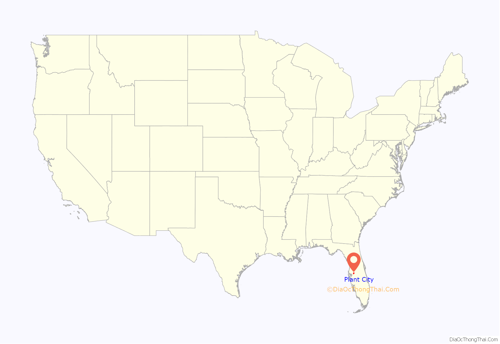
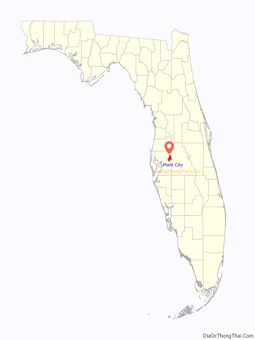
Plant City is an incorporated city in Hillsborough County, Florida, United States, approximately midway between Brandon and Lakeland along Interstate 4. The population was 39,764 at the 2020 census.
Despite many thinking it was named for flora grown at plant nurseries (especially vegetables and fruits, as well as tropical houseplants) in its tropical Gulf Coast climate, it was named after prominent railroad developer Henry B. Plant (see Plant System). Plant City is known as the winter strawberry capital of the world and hosts the annual Florida Strawberry Festival in the late winter (usually in February or early March), which is attended by people from all over the United States as well as many people from around the world.
| Name: | Plant City city |
|---|---|
| LSAD Code: | 25 |
| LSAD Description: | city (suffix) |
| State: | Florida |
| County: | Hillsborough County |
| Elevation: | 128 ft (39 m) |
| Total Area: | 29.12 sq mi (75.43 km²) |
| Land Area: | 28.19 sq mi (73.02 km²) |
| Water Area: | 0.93 sq mi (2.41 km²) |
| Total Population: | 39,764 |
| Population Density: | 1,410.42/sq mi (544.57/km²) |
| ZIP code: | 33563-33567 |
| Area code: | 813 |
| FIPS code: | 1257550 |
| GNISfeature ID: | 0289021 |
| Website: | www.plantcitygov.com |
Online Interactive Map
Click on ![]() to view map in "full screen" mode.
to view map in "full screen" mode.
Plant City location map. Where is Plant City city?
History
Plant City’s original name given during the middle 1800s was Ichepuckesassa (also known as Idasukshed) after the Indian village that once occupied the territory. Its name caused so much confusion that the city was renamed “Cork”, after the postmaster’s Irish hometown. It was finally given the name “Plant City” in commemoration of Henry B. Plant and his railroad, which significantly boosted the commerce in this primarily agricultural community by incorporating it with the South Florida Railroad.
Plant City was the spring training home of baseball’s Cincinnati Reds, who played exhibition games at Plant City Stadium from 1988 to 1997.
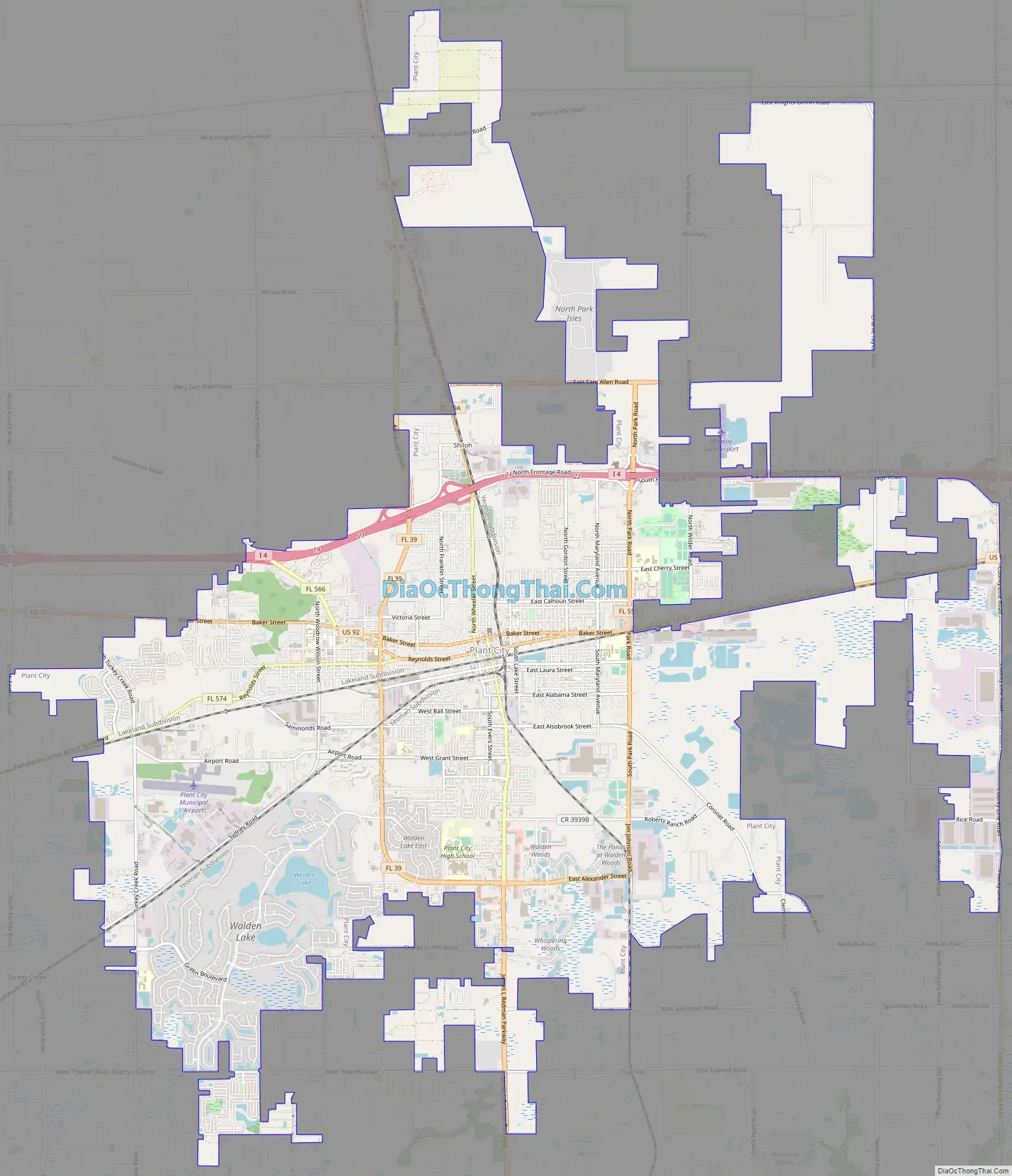
Plant City Road Map
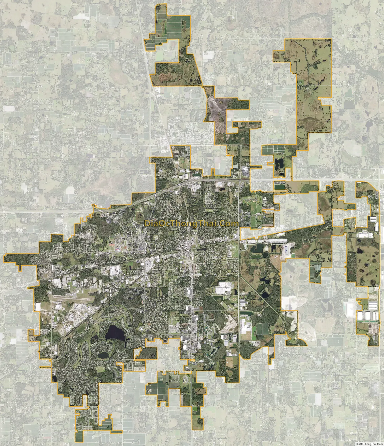
Plant City city Satellite Map
Geography
Plant City is located in northeastern Hillsborough County at 28°1′N 82°8′W / 28.017°N 82.133°W / 28.017; -82.133 (28.0142, –82.1289). Interstate 4 runs through the northern part of the city, with access from Exits 17 through 25. I-4 leads east 12 miles (19 km) to Lakeland and west 23 miles (37 km) to Tampa. U.S. Route 92 is the main highway through the center of Plant City, running generally parallel to I-4. Florida State Road 39 crosses US 92 in the center of Plant City and leads north 15 miles (24 km) to Zephyrhills and south 6 miles (10 km) to Hopewell.
According to the United States Census Bureau, Plant City has a total area of 28.1 square miles (72.8 km), of which 27.2 square miles (70.4 km) are land and 0.93 square miles (2.4 km), or 3.31%, are water.
The city and its surrounding area are in the Southern Flatwoods ecological community as defined by the US Department of Agriculture. The region as a whole is noted for its sandy, infertile, and poorly drained soils. In and around Plant City, however, high organic matter content and scattered phosphate nodules make many of the soils more fertile than typical for the flatwoods.
Climate
Plant City, as does most of Florida, has a humid subtropical climate with humid and hot summers and warm, drier winters. Plant City is close to having a tropical climate since only one month (January) does not have a mean temperature over 64.4 °F (18.0 °C).
See also
Map of Florida State and its subdivision:- Alachua
- Baker
- Bay
- Bradford
- Brevard
- Broward
- Calhoun
- Charlotte
- Citrus
- Clay
- Collier
- Columbia
- Desoto
- Dixie
- Duval
- Escambia
- Flagler
- Franklin
- Gadsden
- Gilchrist
- Glades
- Gulf
- Hamilton
- Hardee
- Hendry
- Hernando
- Highlands
- Hillsborough
- Holmes
- Indian River
- Jackson
- Jefferson
- Lafayette
- Lake
- Lee
- Leon
- Levy
- Liberty
- Madison
- Manatee
- Marion
- Martin
- Miami-Dade
- Monroe
- Nassau
- Okaloosa
- Okeechobee
- Orange
- Osceola
- Palm Beach
- Pasco
- Pinellas
- Polk
- Putnam
- Saint Johns
- Saint Lucie
- Santa Rosa
- Sarasota
- Seminole
- Sumter
- Suwannee
- Taylor
- Union
- Volusia
- Wakulla
- Walton
- Washington
- Alabama
- Alaska
- Arizona
- Arkansas
- California
- Colorado
- Connecticut
- Delaware
- District of Columbia
- Florida
- Georgia
- Hawaii
- Idaho
- Illinois
- Indiana
- Iowa
- Kansas
- Kentucky
- Louisiana
- Maine
- Maryland
- Massachusetts
- Michigan
- Minnesota
- Mississippi
- Missouri
- Montana
- Nebraska
- Nevada
- New Hampshire
- New Jersey
- New Mexico
- New York
- North Carolina
- North Dakota
- Ohio
- Oklahoma
- Oregon
- Pennsylvania
- Rhode Island
- South Carolina
- South Dakota
- Tennessee
- Texas
- Utah
- Vermont
- Virginia
- Washington
- West Virginia
- Wisconsin
- Wyoming


