Apollo Beach is an unincorporated census-designated place in Hillsborough County, Florida, United States. The population was 14,055 at the 2010 census, up from 7,444 at the 2000 census.
| Name: | Apollo Beach CDP |
|---|---|
| LSAD Code: | 57 |
| LSAD Description: | CDP (suffix) |
| State: | Florida |
| County: | Hillsborough County |
| Elevation: | 3 ft (1 m) |
| Total Area: | 22.29 sq mi (57.73 km²) |
| Land Area: | 19.68 sq mi (50.97 km²) |
| Water Area: | 2.61 sq mi (6.77 km²) |
| Total Population: | 26,002 |
| Population Density: | 1,321.31/sq mi (510.16/km²) |
| ZIP code: | 33570, 33572 |
| Area code: | 813 |
| FIPS code: | 1201675 |
| GNISfeature ID: | 1867110 |
Online Interactive Map
Click on ![]() to view map in "full screen" mode.
to view map in "full screen" mode.
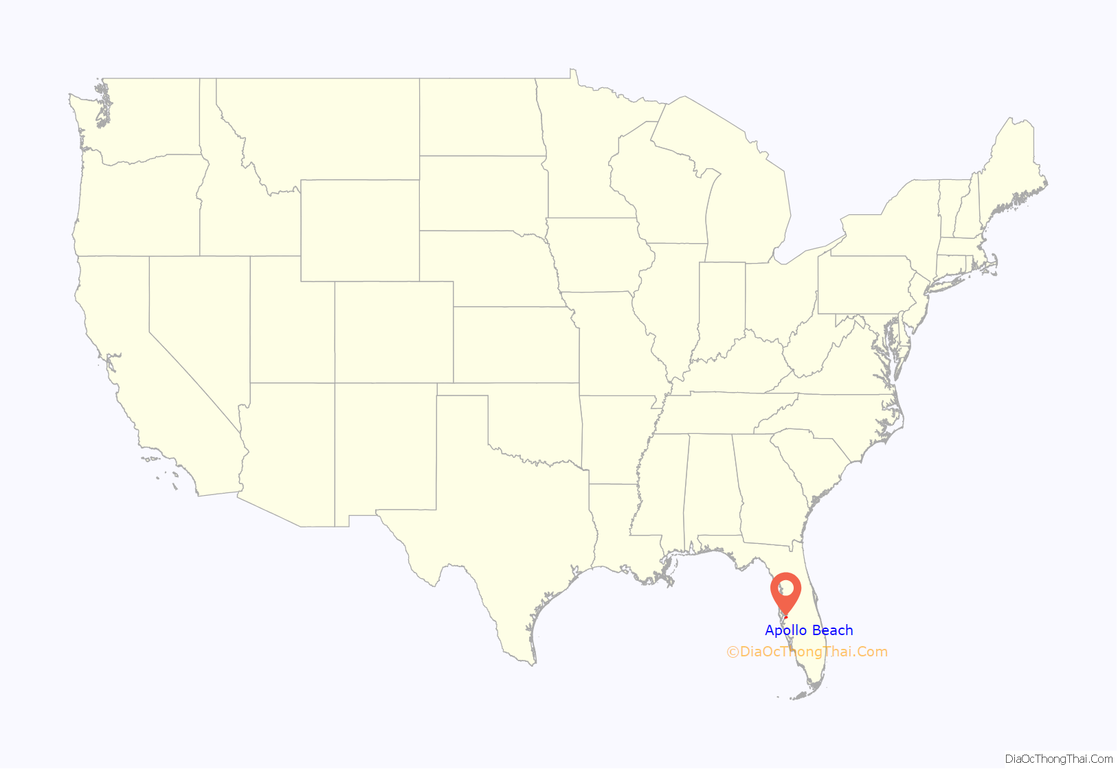
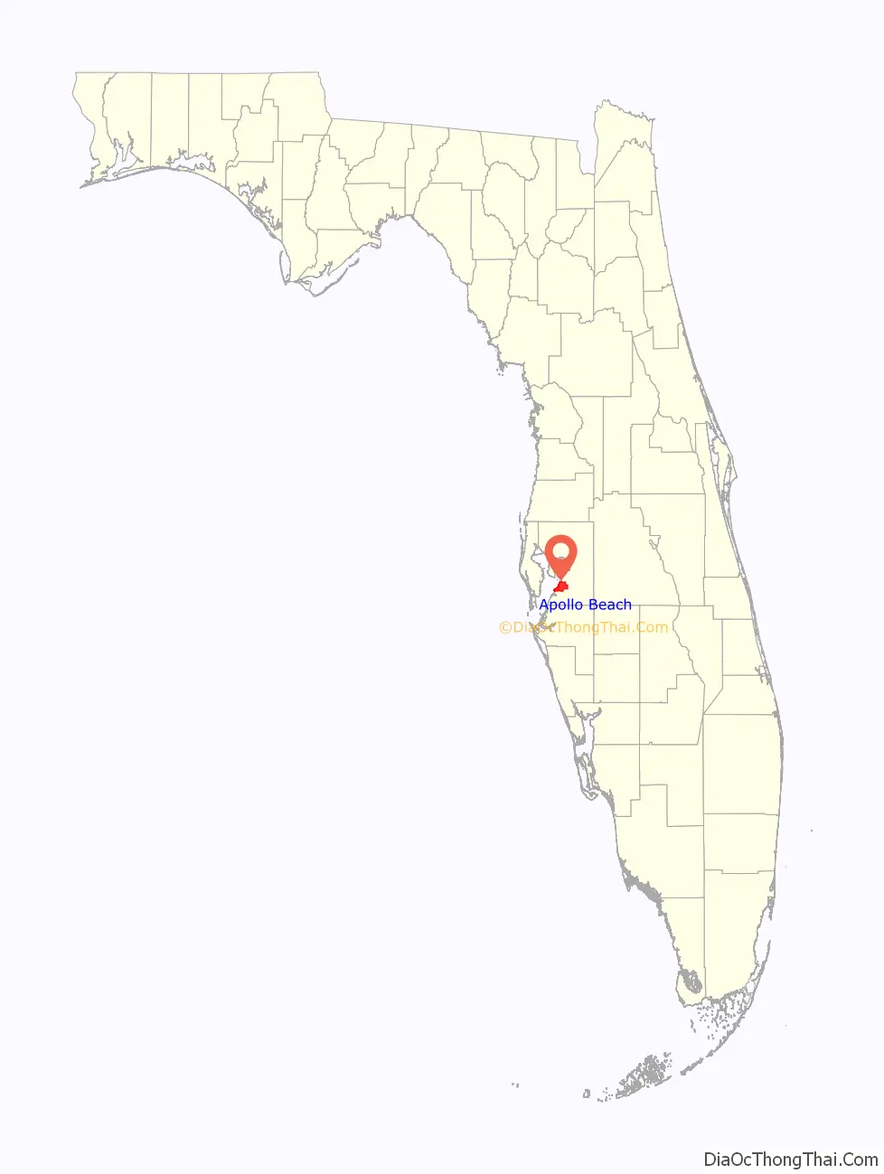
Apollo Beach location map. Where is Apollo Beach CDP?
History
The history of Apollo Beach started in 1923 on land owned by the Dickman family, then used annually for farming and grazing pasture. Much of the land was mangrove and low-elevation and was considered uninhabitable.
In the 1930s, Paul Dickman conceived the idea of a waterfront community. He felt the location was ideally located equidistant between Tampa and Bradenton along U.S. Route 41.
The Dickmans secured the services of Radar Engineering of Miami to design a subdivision including roads, canals, schools, recreation areas, and community services.
In the early 1950s, Dickman negotiated the sale of the land to three men from New York: Turner, Dean and Clark. They named the land “Tampa Beach”, believing the association with Tampa would attract interested persons more readily than a name which did not properly locate the area geographically.
Construction began on the Flamingo Canal near U.S. 41 and proceeded toward Fairway Boulevard. It was their intention to extend the canal to Tampa Bay so as to achieve access to open water. The task became too large for the amount of capital they had invested and for the abilities of the persons involved, and in 1956 they notified Dickman they could not go through with the project.
In 1957, Francis Corr, a retired businessman from Michigan, purchased the land. Corr renamed the area “La Vida Beach”. Legend has it that in 1958 Corr’s wife Dorothy suggested a new name, “Apollo Beach”, for the area’s greatest benefit — sunshine. Mr. Corr started construction of 50 homes in the area between U.S. 41 and Golf & Sea Boulevard.
In early 1958, Corr reached an agreement with Robert E. Lee, a South Carolina contractor, to join in the development. Lee was to continue the dredging of canals, and in exchange was to receive parcels of land.
In the early 1960s, Francis Corr sold his company and the Apollo Beach land to a Miami company known as Flora Sun Corporation. Flora Sun sold some of the land on the northern end to the Tampa Electric Company for a power plant site on the land’s northern border, which is now the Big Bend Power Station. Flora Sun failed in its obligations in the purchase of the land from the Corr family, and about seven years later the family got the land back out of bankruptcy court.
In the mid-1960s, Corr’s son Thomas moved his young family to the area to continue work on the Apollo Beach project; however, while the land was in bankruptcy proceedings from Flora Sun, the dredge and fill permits required to construct the canal system expired.
The Corr family continued to struggle with the development over the years, facing regulatory hurdles and tightening growth policy in Florida with the passage of the growth management act in 1972 and expanded policies in 1984.
Thomas Corr continued to develop the community and donated land for parks and schools and preserving hundreds of acres of mangrove swamps and environmental areas. He started a community bank, a chamber of commerce, civic clubs and festivals. Thomas Corr died in 1998. In 2006, Hillsborough County honored the work of Thomas Corr by naming the new elementary school on Big Bend Road the Thomas P. Corr Elementary School.
Today Apollo Beach is a thriving waterfront community with year-round boating, fishing, and other water activities. The estimated 55 miles (89 km) of canals lead to Tampa Bay.
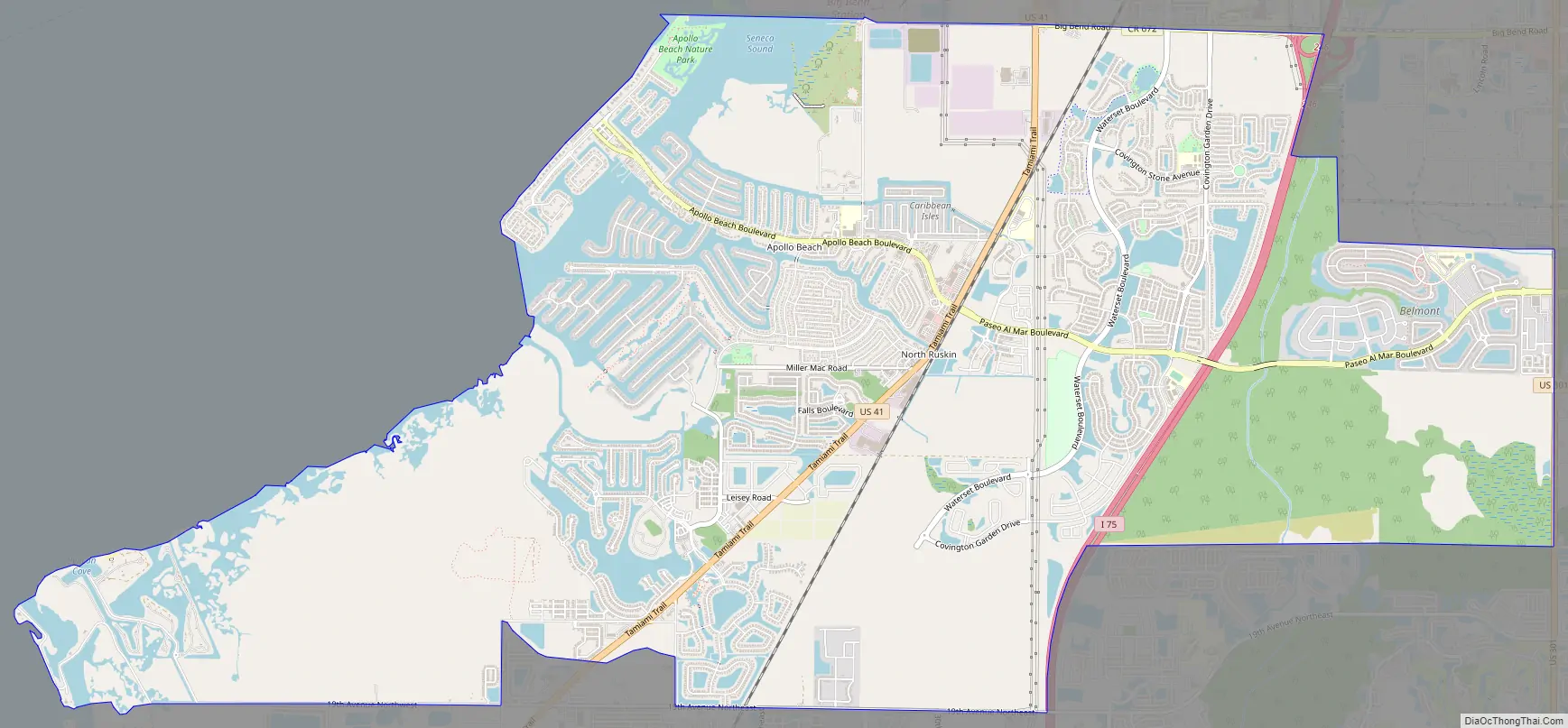
Apollo Beach Road Map
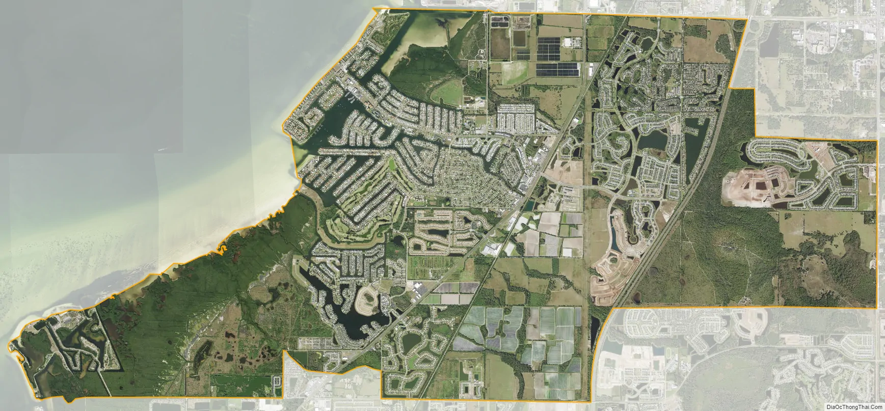
Apollo Beach city Satellite Map
Geography
Apollo Beach is located in southern Hillsborough County and bordered to the north by Gibsonton, to the northeast by Riverview, to the east by Balm, to the southeast by Sun City Center, to the south by Ruskin, and to the west by Tampa Bay. The unincorporated community of North Ruskin is in the northern part of the CDP. U.S. Route 41 crosses the center of the CDP, and Interstate 75 passes through the eastern portion, with access from Exit 246 at the northern edge of the CDP. Downtown Tampa is 17 miles (27 km) to the north, and Bradenton is 25 miles (40 km) to the south.
According to the United States Census Bureau, Apollo Beach CDP has a total area of 22.3 square miles (57.7 km), of which 19.8 square miles (51.4 km) are land and 2.4 square miles (6.3 km), or 10.97%, are water.
See also
Map of Florida State and its subdivision:- Alachua
- Baker
- Bay
- Bradford
- Brevard
- Broward
- Calhoun
- Charlotte
- Citrus
- Clay
- Collier
- Columbia
- Desoto
- Dixie
- Duval
- Escambia
- Flagler
- Franklin
- Gadsden
- Gilchrist
- Glades
- Gulf
- Hamilton
- Hardee
- Hendry
- Hernando
- Highlands
- Hillsborough
- Holmes
- Indian River
- Jackson
- Jefferson
- Lafayette
- Lake
- Lee
- Leon
- Levy
- Liberty
- Madison
- Manatee
- Marion
- Martin
- Miami-Dade
- Monroe
- Nassau
- Okaloosa
- Okeechobee
- Orange
- Osceola
- Palm Beach
- Pasco
- Pinellas
- Polk
- Putnam
- Saint Johns
- Saint Lucie
- Santa Rosa
- Sarasota
- Seminole
- Sumter
- Suwannee
- Taylor
- Union
- Volusia
- Wakulla
- Walton
- Washington
- Alabama
- Alaska
- Arizona
- Arkansas
- California
- Colorado
- Connecticut
- Delaware
- District of Columbia
- Florida
- Georgia
- Hawaii
- Idaho
- Illinois
- Indiana
- Iowa
- Kansas
- Kentucky
- Louisiana
- Maine
- Maryland
- Massachusetts
- Michigan
- Minnesota
- Mississippi
- Missouri
- Montana
- Nebraska
- Nevada
- New Hampshire
- New Jersey
- New Mexico
- New York
- North Carolina
- North Dakota
- Ohio
- Oklahoma
- Oregon
- Pennsylvania
- Rhode Island
- South Carolina
- South Dakota
- Tennessee
- Texas
- Utah
- Vermont
- Virginia
- Washington
- West Virginia
- Wisconsin
- Wyoming


