Forest Park is the second most populous city in Hamilton County, Ohio, United States. It is a suburb of Cincinnati. The population was 20,189 at the 2020 census.
| Name: | Forest Park city |
|---|---|
| LSAD Code: | 25 |
| LSAD Description: | city (suffix) |
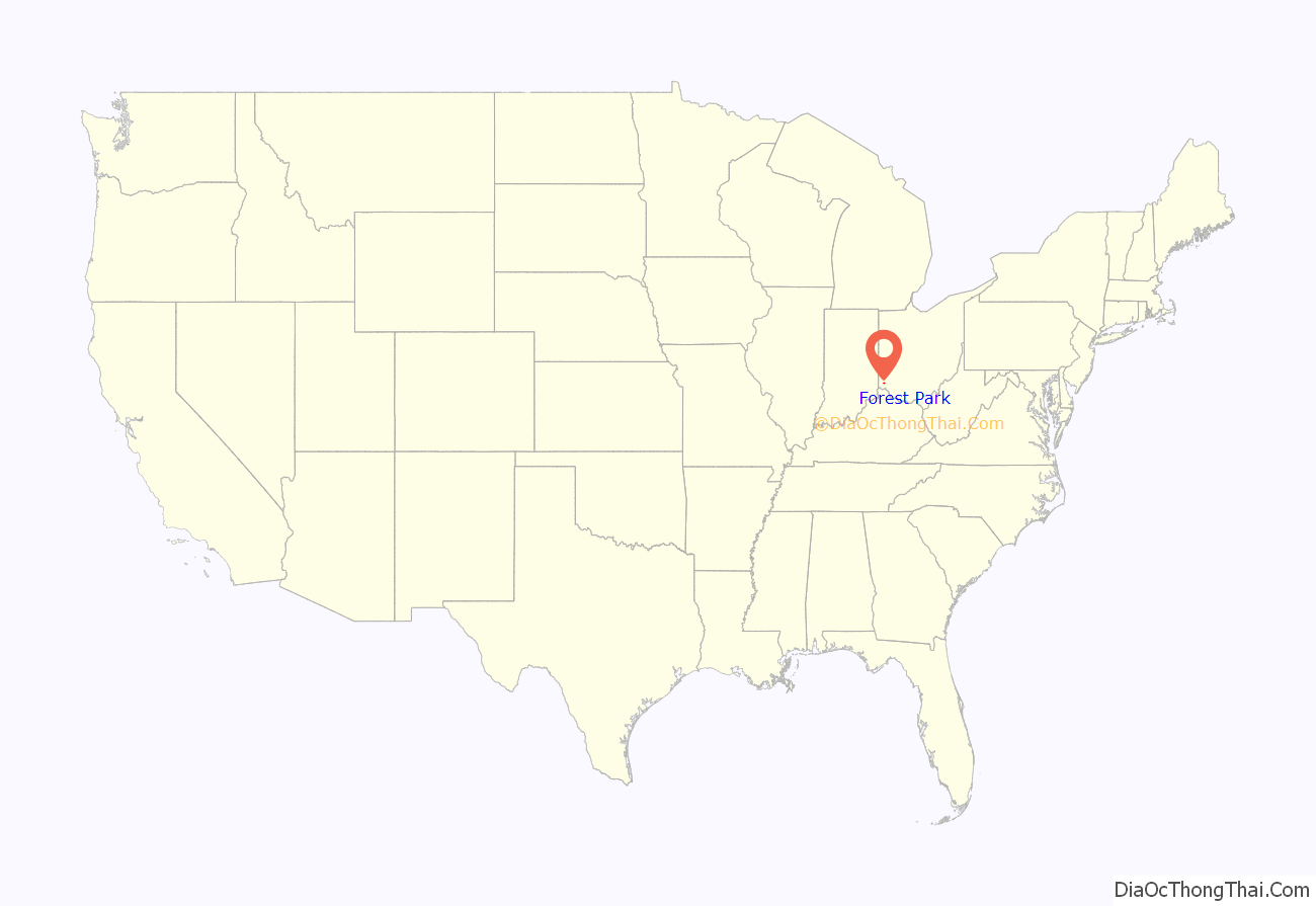
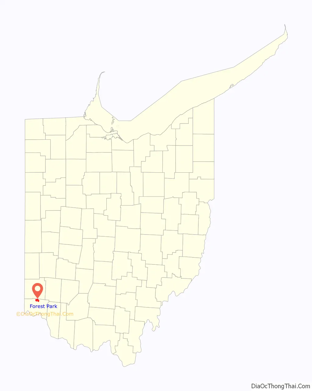
| State: | Ohio |
| County: | Hamilton County |
| Elevation: | 837 ft (255 m) |
| Total Area: | 6.45 sq mi (16.72 km²) |
| Land Area: | 6.45 sq mi (16.70 km²) |
| Water Area: | 0.01 sq mi (0.01 km²) |
| Total Population: | 20,189 |
| Population Density: | 3,130.56/sq mi (1,208.70/km²) |
| ZIP code: | 45240 |
| Area code: | 513 |
| FIPS code: | 3927706 |
| GNISfeature ID: | 1040570 |
| Website: | www.forestpark.org |
Online Interactive Map
Click on ![]() to view map in "full screen" mode.
to view map in "full screen" mode.
Forest Park location map. Where is Forest Park city?
History
The City of Forest Park, Ohio was founded in 1956, two years after private developers Marvin Warner and Joseph Kanter purchased 3,400 acres of 5,930 acres north of Cincinnati originally set aside in 1935 by the Resettlement Administration under President Franklin D. Roosevelt to relocate struggling urban and rural families to one of three such communities planned by the government called Greenbelt towns.
The Greenbelt concept was abandoned in 1949 and the as yet undeveloped acreage of Greenhills, Ohio, which had opened in 1938, became available for purchase by the Warner-Kanter Corporation in 1954. After two years of planning they opened homes for purchase in the first residential area of Forest Park, the C section, in March 1956.
After growing to a population of 4800 in 1960 and incorporation as a village in 1961, then achieving city status in 1968, Forest Park intentionally became an “open city,” regularly adopting and passing resolutions and ordinances welcoming citizens regardless of race, creed or national origin, a policy intended to maintain the city’s commitment to diversity.
Toward this end, in 1978, the Forest Park Housing Commission created “A Comprehensive Strategy for Maintaining Diversity in Forest Park, “to combat discriminatory practices by realtors, builders and corporations.”
After a 1980 lawsuit filed by the city against a builder was dismissed for insufficient evidence, the Forest Park council issued a statement declaring that “people have the right to choose where to live, work or play based on their own free choice. That right must be secured for all people and never be artificially restricted.”
The Quality of Integrated Life resolution of 1982 would serve as a guide to integrated living, reinforcing the long-held view that diversity was a strength of Forest Park as the city moved toward a new century. In 1991 this view was reinforced when a Quality of Life Task Force issued a vision statement reflecting the “shared values of a multicultural citizenry.”
In the minds of its residents and outsiders, Forest Park’s commitment to diversity in an open community became a model for 21st century living.
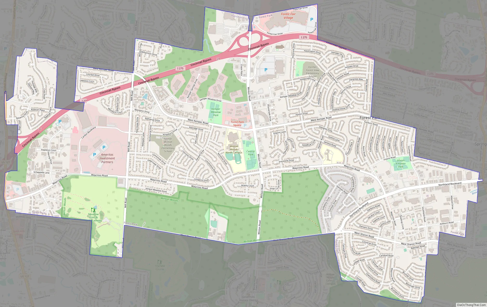
Forest Park Road Map
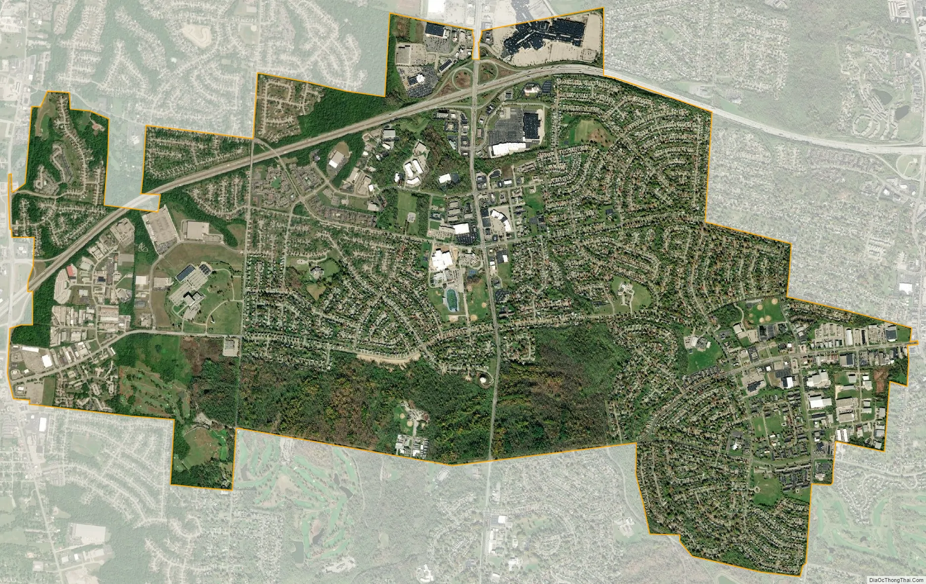
Forest Park city Satellite Map
Geography
Forest Park is located at 39°17′11″N 84°31′13″W / 39.28639°N 84.52028°W / 39.28639; -84.52028 (39.286408, -84.520363).
According to the United States Census Bureau, the city has a total area of 6.48 square miles (16.78 km), all land.
Borders
Forest Park borders the following:
See also
Map of Ohio State and its subdivision:- Adams
- Allen
- Ashland
- Ashtabula
- Athens
- Auglaize
- Belmont
- Brown
- Butler
- Carroll
- Champaign
- Clark
- Clermont
- Clinton
- Columbiana
- Coshocton
- Crawford
- Cuyahoga
- Darke
- Defiance
- Delaware
- Erie
- Fairfield
- Fayette
- Franklin
- Fulton
- Gallia
- Geauga
- Greene
- Guernsey
- Hamilton
- Hancock
- Hardin
- Harrison
- Henry
- Highland
- Hocking
- Holmes
- Huron
- Jackson
- Jefferson
- Knox
- Lake
- Lake Erie
- Lawrence
- Licking
- Logan
- Lorain
- Lucas
- Madison
- Mahoning
- Marion
- Medina
- Meigs
- Mercer
- Miami
- Monroe
- Montgomery
- Morgan
- Morrow
- Muskingum
- Noble
- Ottawa
- Paulding
- Perry
- Pickaway
- Pike
- Portage
- Preble
- Putnam
- Richland
- Ross
- Sandusky
- Scioto
- Seneca
- Shelby
- Stark
- Summit
- Trumbull
- Tuscarawas
- Union
- Van Wert
- Vinton
- Warren
- Washington
- Wayne
- Williams
- Wood
- Wyandot
- Alabama
- Alaska
- Arizona
- Arkansas
- California
- Colorado
- Connecticut
- Delaware
- District of Columbia
- Florida
- Georgia
- Hawaii
- Idaho
- Illinois
- Indiana
- Iowa
- Kansas
- Kentucky
- Louisiana
- Maine
- Maryland
- Massachusetts
- Michigan
- Minnesota
- Mississippi
- Missouri
- Montana
- Nebraska
- Nevada
- New Hampshire
- New Jersey
- New Mexico
- New York
- North Carolina
- North Dakota
- Ohio
- Oklahoma
- Oregon
- Pennsylvania
- Rhode Island
- South Carolina
- South Dakota
- Tennessee
- Texas
- Utah
- Vermont
- Virginia
- Washington
- West Virginia
- Wisconsin
- Wyoming


