South Carolina (/ˌkærəˈlaɪnə/ (listen)) is a state in the coastal Southeastern region of the United States. It is bordered to the north by North Carolina, to the southeast by the Atlantic Ocean, and to the southwest by Georgia across the Savannah River. South Carolina is the 40th most extensive and 23rd most populous U.S. state with a recorded population of 5,124,712 according to the 2020 census. In 2019, its GDP was $213.45 billion. South Carolina is composed of 46 counties. The capital is Columbia with a population of 137,300 in 2020; while its largest city is Charleston with a 2020 population of 150,277. The Greenville–Spartanburg-Anderson metropolitan area is the most populous in the state, with a 2020 population estimate of 1,455,892.
South Carolina was named in honor of King Charles I of England, who first formed the English colony, with Carolus being Latin for “Charles”. In 1712 the Province of South Carolina was formed. One of the original Thirteen Colonies, South Carolina became a royal colony in 1719. During the American Revolutionary War, South Carolina was the site of major activity among the American colonies, with more than 200 battles and skirmishes fought within the state. South Carolina became the eighth state to ratify the U.S. Constitution on May 23, 1788. A slave state, it was the first state to vote in favor of secession from the Union on December 20, 1860. After the American Civil War, it was readmitted into the United States on July 9, 1868.
During the early-to-mid 20th century, the state started to see economic progress as many textile mills and factories were built across the state. The civil rights movement of the mid-20th century helped end segregation and legal discrimination policies within the state. Economic diversification in South Carolina continued to pick up speed during and in the ensuing decades after World War II. In the early 21st century, South Carolina’s economy is based on industries such as aerospace, agribusiness, automotive manufacturing, and tourism.
Within South Carolina from east to west are three main geographic regions, the Atlantic coastal plain, the Piedmont, and the Blue Ridge Mountains in the northwestern corner of Upstate South Carolina. South Carolina has primarily a humid subtropical climate, with hot, humid summers and mild winters. Areas in the Upstate have a subtropical highland climate. Along South Carolina’s eastern coastal plain are many salt marshes and estuaries. South Carolina’s southeastern Lowcountry contains portions of the Sea Islands, a chain of barrier islands along the Atlantic Ocean.
| Before statehood: | Province of South Carolina |
|---|---|
| Admitted to the Union: | May 23, 1788 (8th) |
| Capital: | Columbia |
| Largest city: | Charleston |
| Largest metro and urban areas: | Greenville (combined and metro) Columbia (urban) |
| Elevation: | 350 ft (110 m) |
| Total Area: | 32,020 sq mi (82,932 km) |
| Area Rank: | 40th |
| Total Population: | 5,282,634 |
| Population Rank: | 23rd |
| Population Density: | 175.45/sq mi (67.74/km) |
| Population Density Rank: | 19th |
| Median Household Income: | $50,570 |
| Income Rank: | 41st |
| Demonym(s): | South Carolinian |
| USPS abbreviation: | SC |
| ISO 3166 code: | US-SC |
| Website: | sc.gov |
Online Interactive Map
Click on ![]() to view map in "full screen" mode.
to view map in "full screen" mode.
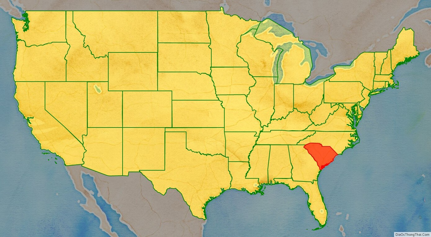
South Carolina location map. Where is South Carolina state?
South Carolina Road Map
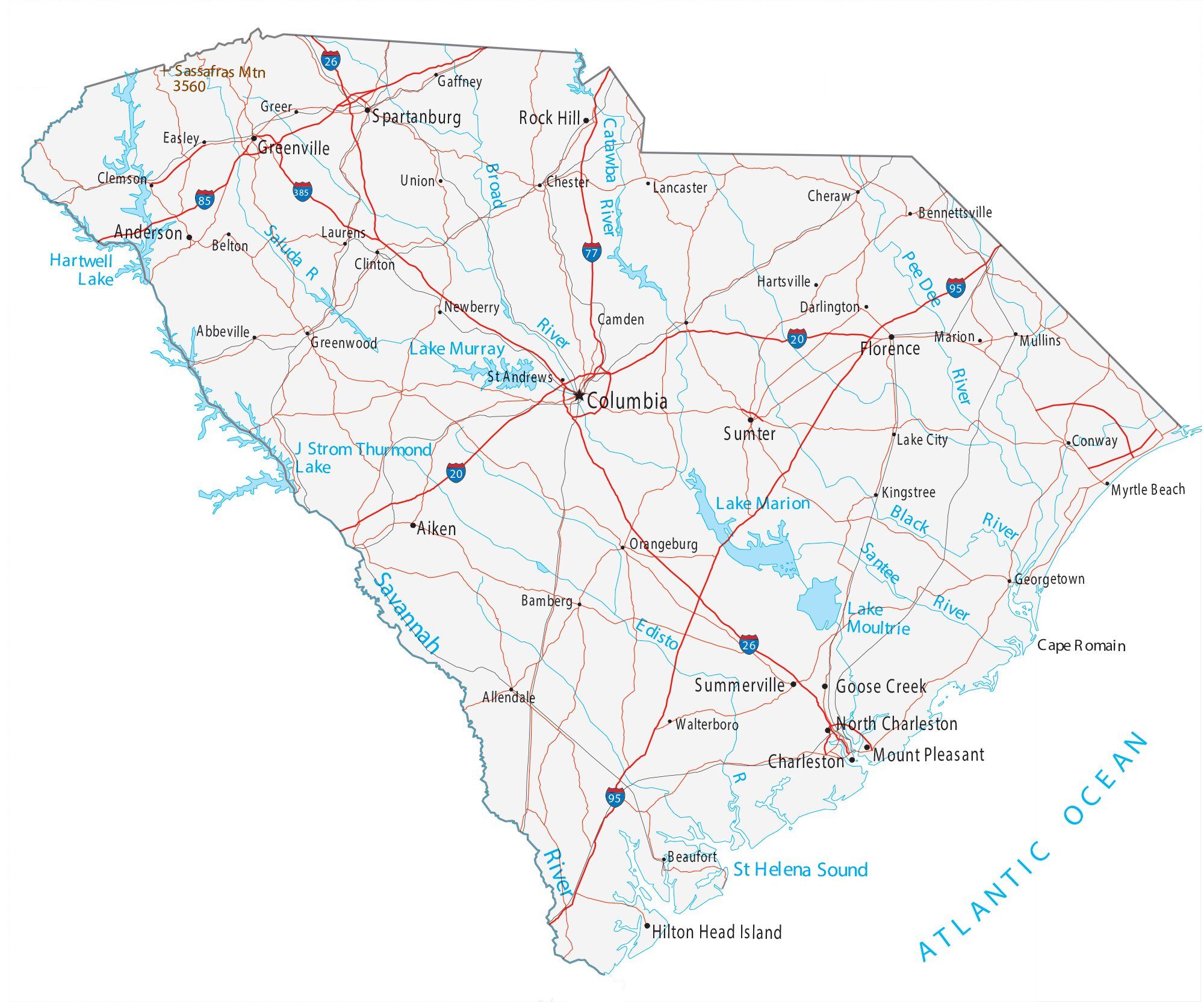
South Carolina Map – Roads & Cities
South Carolina Street Map
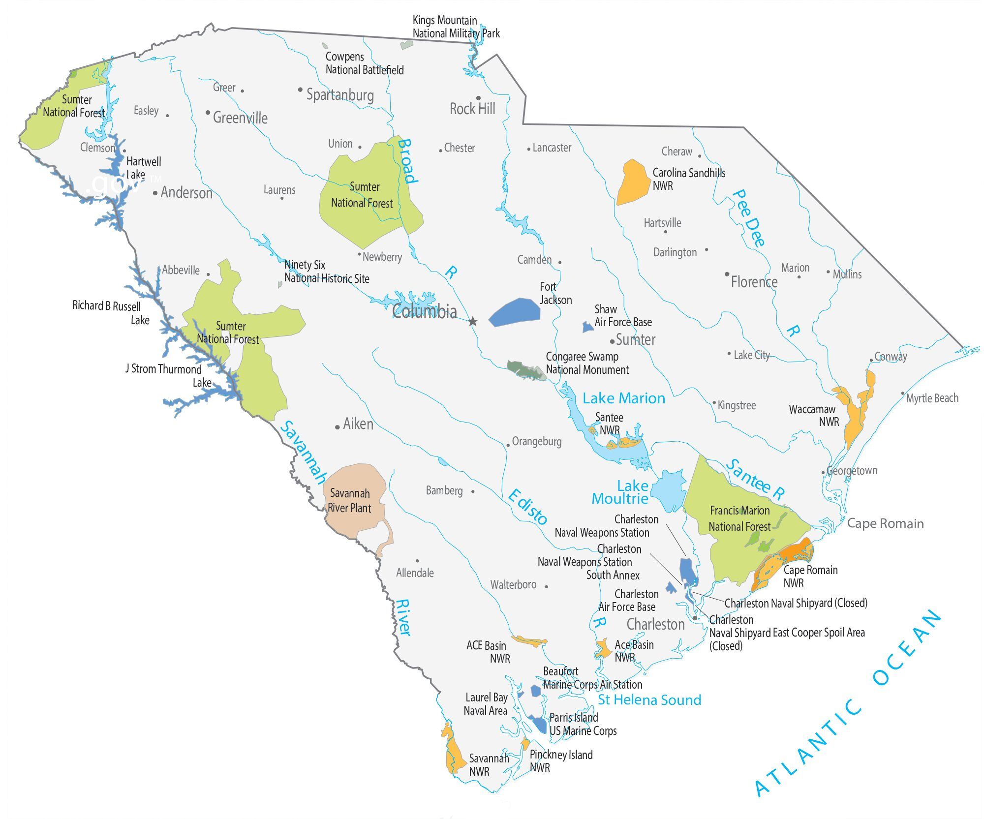
South Carolina State Map – Places and Landmarks
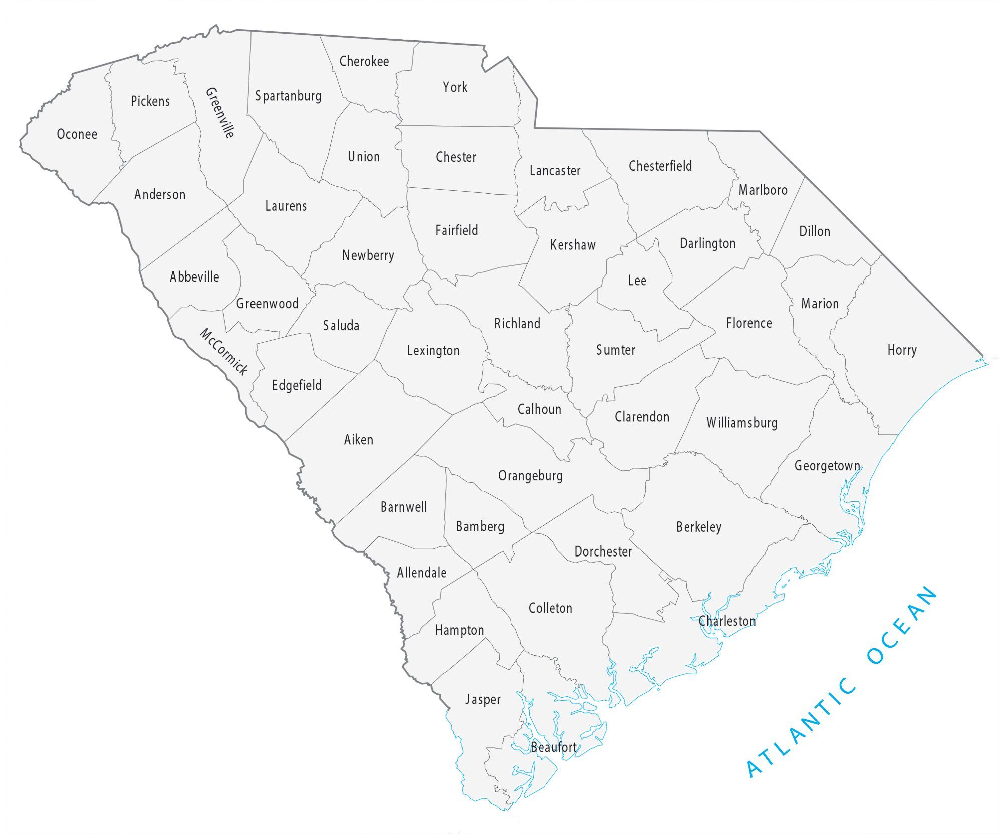
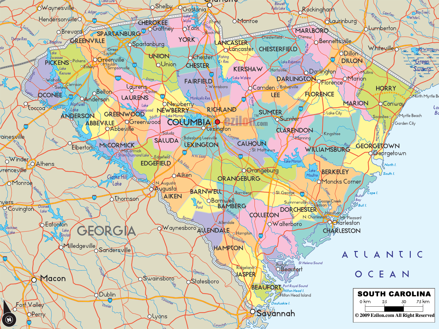
South Carolina Political Map
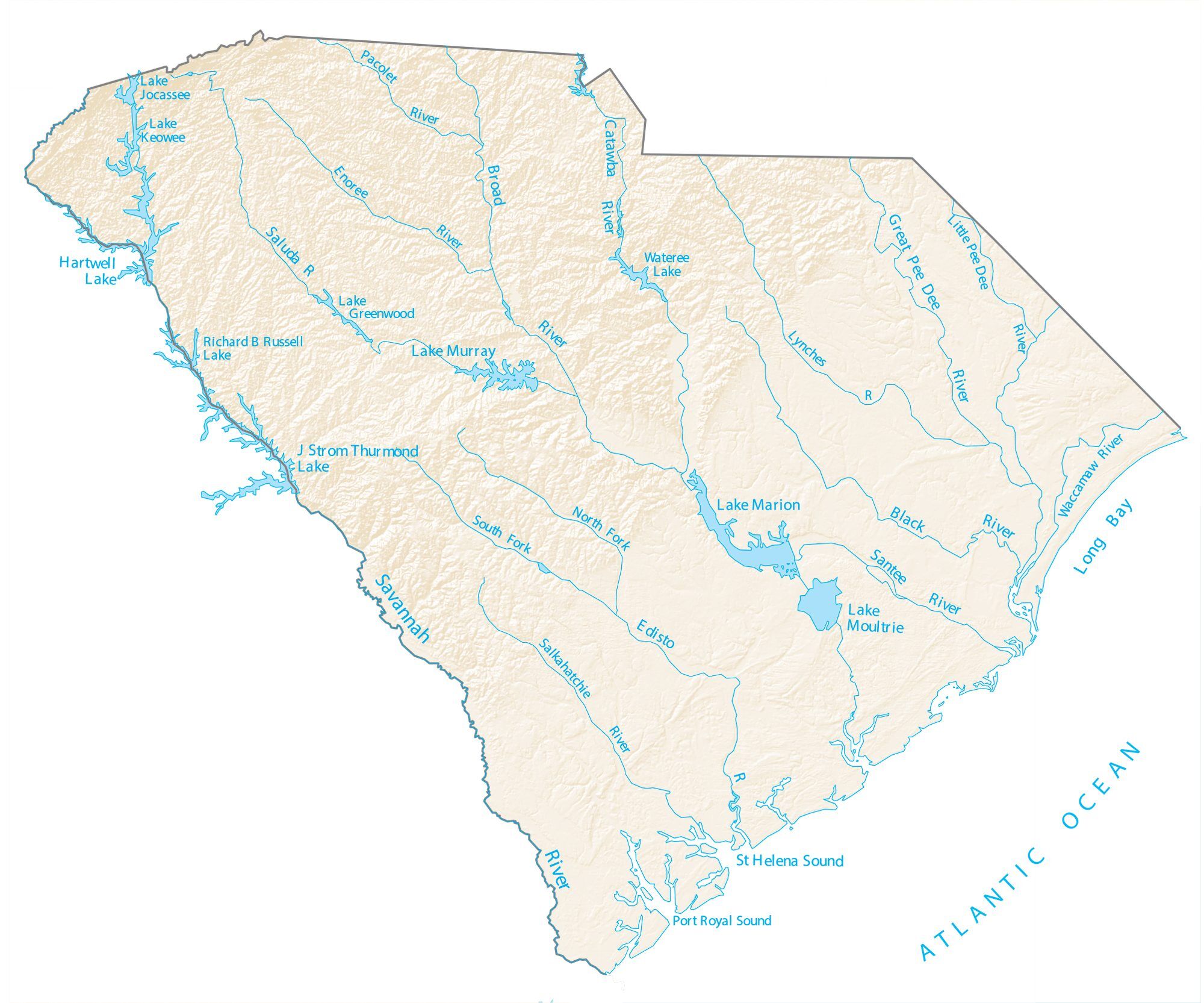
South Carolina Lakes and Rivers Map
Geography
Regions
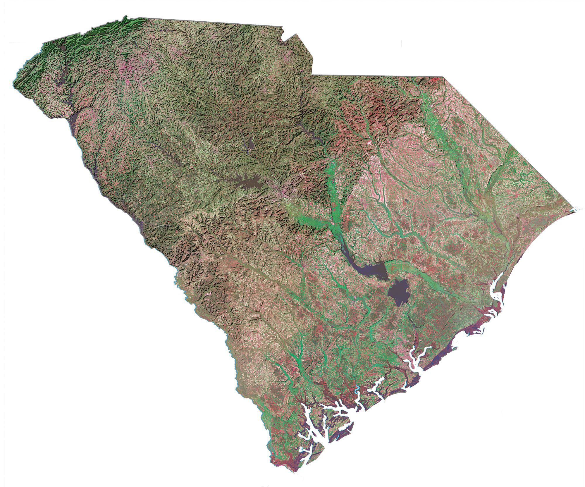
The state can be divided into three natural geographic areas which then can be subdivided into five distinct cultural regions. The natural environment is divided from east to west by the Atlantic coastal plain, the Piedmont, and the Blue Ridge Mountains. Culturally, the coastal plain is split into the Lowcountry and the Pee Dee region. While, the upper Piedmont region is referred to as the Piedmont and the lower Piedmont region is referred to as the Midlands. The area surrounding the Blue Ridge Mountains is known as the Upstate. The Atlantic Coastal Plain makes up two-thirds of the state. Its eastern border is the Sea Islands, a chain of tidal and barrier islands. The border between the lowcountry and the upcountry is defined by the Atlantic Seaboard fall line, which marks the limit of navigable rivers.
Atlantic Coastal Plain
The Atlantic Coastal plain consists of sediments and sedimentary rocks that range in age from Cretaceous to Present. The terrain is relatively flat and the soil is composed predominantly of sand, silt, and clay. Areas with better drainage make excellent farmland, though some land is swampy. An unusual feature of the coastal plain is a large number of low-relief topographic depressions named Carolina bays. The bays tend to be oval, lining up in a northwest to southeast orientation. The eastern portion of the coastal plain contains many salt marshes and estuaries, as well as natural ports such as Georgetown and Charleston. The natural areas of the coastal plain are part of the Middle Atlantic coastal forests ecoregion.
The Sandhills or Carolina Sandhills is a 10–35 mi (16–56 km) wide region within the Atlantic Coastal Plain province, along the inland margin of this province. The Carolina Sandhills are interpreted as eolian (wind-blown) sand sheets and dunes that were mobilized episodically from approximately 75,000 to 6,000 years ago. Most of the published luminescence ages from the sand are coincident with the last glaciation, a time when the southeastern United States was characterized by colder air temperatures and stronger winds.
Piedmont
Much of Piedmont consists of Paleozoic metamorphic and igneous rocks, and the landscape has relatively low relief. Due to the changing economics of farming, much of the land is now reforested in loblolly pine for the lumber industry. These forests are part of the Southeastern mixed forests ecoregion. At the southeastern edge of Piedmont is the fall line, where rivers drop to the coastal plain. The fall line was an important early source of water power. Mills built to this resource encouraged the growth of several cities, including the capital, Columbia. The larger rivers are navigable up to the fall line, providing a trade route for mill towns.
The northwestern part of Piedmont is also known as the Foothills. The Cherokee Parkway is a scenic driving route through this area. This is where Table Rock State Park is located.
Blue Ridge
The Blue Ridge consists primarily of Precambrian metamorphic rocks, and the landscape has relatively high relief. The Blue Ridge Region contains an escarpment of the Blue Ridge Mountains that continues into North Carolina and Georgia as part of the southern Appalachian Mountains. Sassafras Mountain, South Carolina’s highest point at 3,560 feet (1,090 m), is in this area. Also in this area is Caesars Head State Park. The environment here is that of the Appalachian-Blue Ridge forests ecoregion. The Chattooga River, on the border between South Carolina and Georgia, is a favorite whitewater rafting destination.
Lakes
South Carolina has several major lakes covering over 683 square miles (1,770 km). All major lakes in South Carolina are man-made. The following are the lakes listed by size.
- Lake Marion 110,000 acres (450 km)
- Lake Strom Thurmond (also known as Clarks Hill Lake) 71,100 acres (290 km)
- Lake Moultrie 60,000 acres (240 km)
- Lake Hartwell 56,000 acres (230 km)
- Lake Murray 50,000 acres (200 km)
- Russell Lake 26,650 acres (110 km)
- Lake Keowee 18,372 acres (70 km)
- Lake Wylie 13,400 acres (50 km)
- Lake Wateree 13,250 acres (50 km)
- Lake Greenwood 11,400 acres (50 km)
- Lake Jocassee 7,500 acres (30 km)
- Lake Bowen 1,534 acres (6.21 km)
Earthquakes
South Carolina is the most seismically active state on the east coast. Between July 1, 2021, and July 1, 2022, there were 74 recorded earthquakes in South Carolina, six of which exceeded a 3 magnitude. In 2021 and 2022, most of which were concentrated in Kershaw County and the coastal area of Charleston. The Charleston area demonstrates the greatest frequency of earthquakes in South Carolina. South Carolina averages 10–15 earthquakes a year below magnitude 3 (FEMA). The Charleston earthquake of 1886 was the largest quake ever to hit the eastern United States. The 7.0–7.3 magnitude earthquake killed 60 people and destroyed much of the city. Faults in this region are difficult to study at the surface due to thick sedimentation on top of them. Many of the ancient faults are within plates rather than along plate boundaries.
Climate
South Carolina has a humid subtropical climate (Köppen climate classification Cfa), although high-elevation areas in the Upstate area have fewer subtropical characteristics than areas on the Atlantic coastline. In the summer, South Carolina is hot and humid, with daytime temperatures averaging between 86–93 °F (30–34 °C) in most of the state and overnight lows averaging 70–75 °F (21–24 °C) on the coast and from 66–73 °F (19–23 °C) inland. Winter temperatures are much less uniform in South Carolina. Coastal areas of the state have very mild winters, with high temperatures approaching an average of 60 °F (16 °C) and overnight lows around 40 °F (5–8 °C).
Inland, the average January overnight low is around 32 °F (0 °C) in Columbia and temperatures well below freezing in the Upstate. While precipitation is abundant the entire year in almost the entire state, the coast tends to have a slightly wetter summer, while inland, the spring and autumn transitions tend to be the wettest periods and winter the driest season, with November being the driest month. The highest recorded temperature is 113 °F (45 °C) in Johnston and Columbia on June 29, 2012, and the lowest recorded temperature is −19 °F (−28 °C) at Caesars Head on January 21, 1985.
Snowfall in South Carolina is minimal in the lower elevation areas south and east of Columbia. It is not uncommon for areas along the southernmost coast to not receive measurable snowfall for several years. In the Piedmont and Foothills, especially along and north of Interstate 85, measurable snowfall occurs one to three times in most years. Annual average total amounts range from 2 to 6 inches. The Blue Ridge Escarpment receives the most average total measurable snowfall; amounts range from 7 to 12 inches.
South Carolina is also prone to tropical cyclones and tornadoes. Two of the strongest hurricanes to strike South Carolina in recent history were Hurricane Hazel (1954) and Hurricane Hugo (1989).
The state is occasionally affected by tropical cyclones. This is an annual concern during hurricane season, which lasts from June 1 to November 30. The peak time of vulnerability for the southeast Atlantic coast is from early August to early October, during the Cape Verde hurricane season. Memorable hurricanes to hit South Carolina include Hazel (1954), Hugo (1989), and Florence (2018).
South Carolina averages around 50 days of thunderstorm activity a year. This is less than some of the states further south, and it is slightly less vulnerable to tornadoes than the states which border on the Gulf of Mexico. Some notable tornadoes have struck South Carolina, and the state averages around 14 tornadoes annually. Hail is common with many of the thunderstorms in the state, as there is often a marked contrast in temperature of warmer ground conditions compared to the cold air aloft.
Climate change in South Carolina encompasses the effects of climate change, attributed to man-made increases in atmospheric carbon dioxide, in the U.S. state of South Carolina.
Studies show that South Carolina is among a string of “Deep South” states that will experience the worst effects of climate change. According to the United States Environmental Protection Agency:
South Carolina released its Climate, Energy, and Commerce Committee Final Report in 2008. The report recommends a voluntary economy-wide goal of reducing emissions to 5% below 1990 levels by 2020. Key policy recommendations in the report include developing renewable portfolio standards, increasing use of local agricultural products, and increasing advanced recycling and composting.
Federal lands in South Carolina
- Charles Pinckney National Historic Site at Mt. Pleasant
- Congaree National Park in Hopkins
- Cowpens National Battlefield near Chesnee
- Fort Moultrie National Monument at Sullivan’s Island
- Fort Sumter National Monument in Charleston Harbor
- Kings Mountain National Military Park at Blacksburg
- Ninety Six National Historic Site in Ninety Six
- Overmountain Victory National Historic Trail
- Fort Jackson near Columbia
- Joint Base Charleston near Charleston
- Shaw Air Force Base near Sumter
- Marine Corps Recruit Depot Parris Island at Parris Island
Flora and fauna
South Carolina is home to two dominant ecosystems, the bottomlands, which consist of floodplains and creeks, and the toplands. The floodplains contain large tracts of old and mature second growth cypress and tupelo forest. The uplands are home to longleaf pine, shortleaf pine, and mixed hardwood forests. The Longleaf Pine are an important part of South Carolina’s coastal ecosystem. They improve soil, water, and air quality while a habitat for deer and songbirds. These forests are endangered by logging for agriculture and development.
Oysters are a critical part of South Carolina’s coastal ecology. They serve a dual function, filtering the water and forming reefs that provide a habitat for small fish and crabs. Oysters are imperiled by overharvesting because young oysters need older oysters to latch on to as they age. South Carolina is home to many shorebirds including various sandpipers and ibises. The state serves as a stopover site for birds migrating farther south and a wintering ground for birds that do not fly as far south.
Population centers
Some Primary Statistical Areas of South Carolina overlap with neighboring states of North Carolina and Georgia
The following table shows the major metropolitan areas of South Carolina.
South Carolina Physical Map
South Carolina Topographic Map
South Carolina Satellite Map
Others printable maps
South Carolina Outline Map
Blank South Carolina County Map
See also
Map of South Carolina State and its subdivision:- Abbeville
- Aiken
- Allendale
- Anderson
- Bamberg
- Barnwell
- Beaufort
- Berkeley
- Calhoun
- Charleston
- Cherokee
- Chester
- Chesterfield
- Clarendon
- Colleton
- Darlington
- Dillon
- Dorchester
- Edgefield
- Fairfield
- Florence
- Georgetown
- Greenville
- Greenwood
- Hampton
- Horry
- Jasper
- Kershaw
- Lancaster
- Laurens
- Lee
- Lexington
- Marion
- Marlboro
- McCormick
- Newberry
- Oconee
- Orangeburg
- Pickens
- Richland
- Saluda
- Spartanburg
- Sumter
- Union
- Williamsburg
- York
- Alabama
- Alaska
- Arizona
- Arkansas
- California
- Colorado
- Connecticut
- Delaware
- District of Columbia
- Florida
- Georgia
- Hawaii
- Idaho
- Illinois
- Indiana
- Iowa
- Kansas
- Kentucky
- Louisiana
- Maine
- Maryland
- Massachusetts
- Michigan
- Minnesota
- Mississippi
- Missouri
- Montana
- Nebraska
- Nevada
- New Hampshire
- New Jersey
- New Mexico
- New York
- North Carolina
- North Dakota
- Ohio
- Oklahoma
- Oregon
- Pennsylvania
- Rhode Island
- South Carolina
- South Dakota
- Tennessee
- Texas
- Utah
- Vermont
- Virginia
- Washington
- West Virginia
- Wisconsin
- Wyoming
