Carlsbad is a coastal city in the North County region of San Diego County, California, United States. The city is 87 miles (140 km) south of downtown Los Angeles and 35 miles (56 km) north of downtown San Diego. As of the 2020 census, the population of the city was 114,746. Carlsbad is a popular tourist destination and home to many businesses in the golf industry.
| Name: | Carlsbad city |
|---|---|
| LSAD Code: | 25 |
| LSAD Description: | city (suffix) |
| State: | California |
| County: | San Diego County |
| Incorporated: | July 16, 1952 |
| Elevation: | 52 ft (16 m) |
| Total Area: | 39.08 sq mi (101.21 km²) |
| Land Area: | 37.77 sq mi (97.83 km²) |
| Water Area: | 1.30 sq mi (3.38 km²) 3.55% |
| Total Population: | 114,746 |
| Population Density: | 3,038.02/sq mi (1,172.91/km²) |
| ZIP code: | 92008–92011, 92018 |
| FIPS code: | 0611194 |
| Website: | www.carlsbadca.gov |
Online Interactive Map
Click on ![]() to view map in "full screen" mode.
to view map in "full screen" mode.
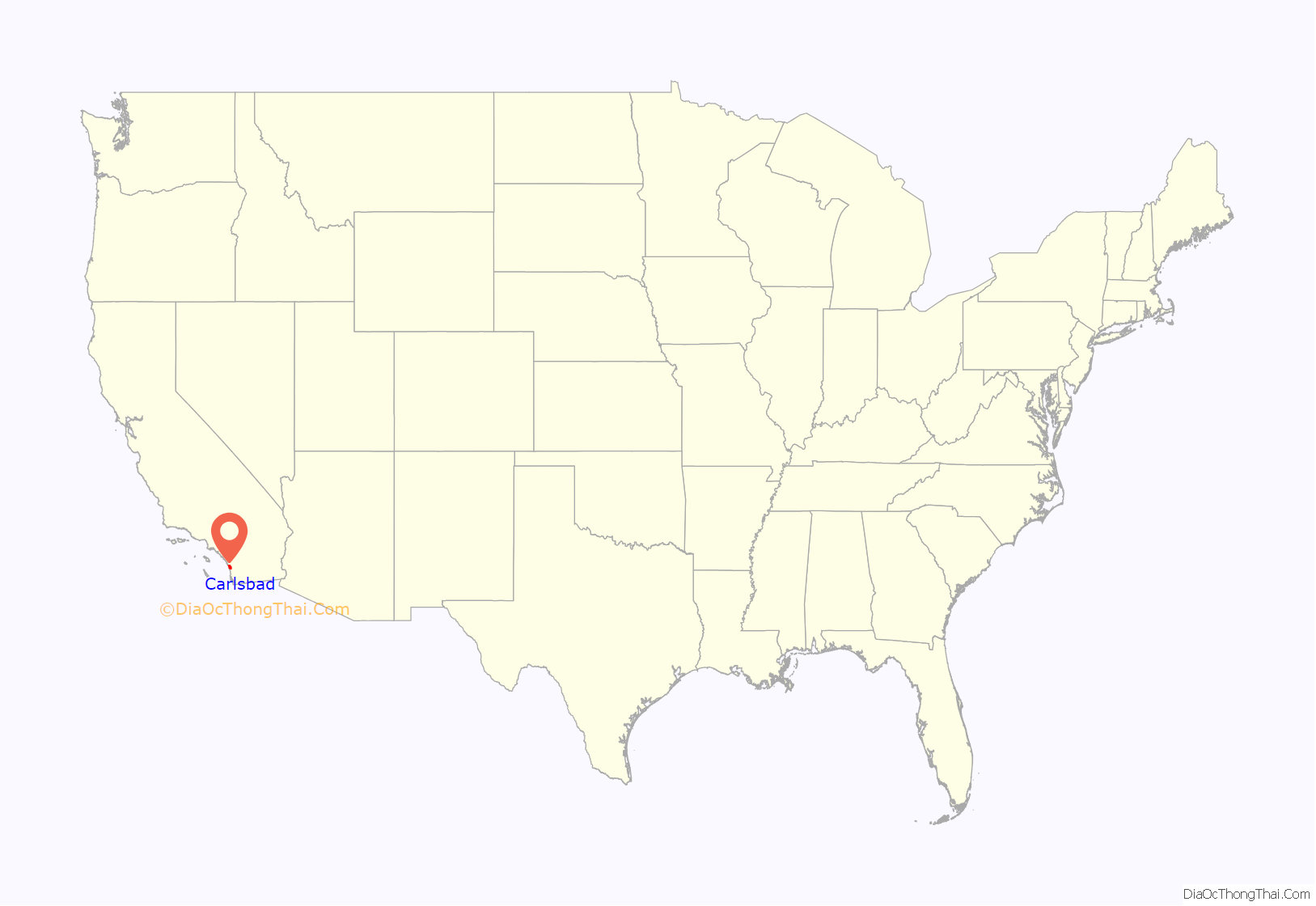
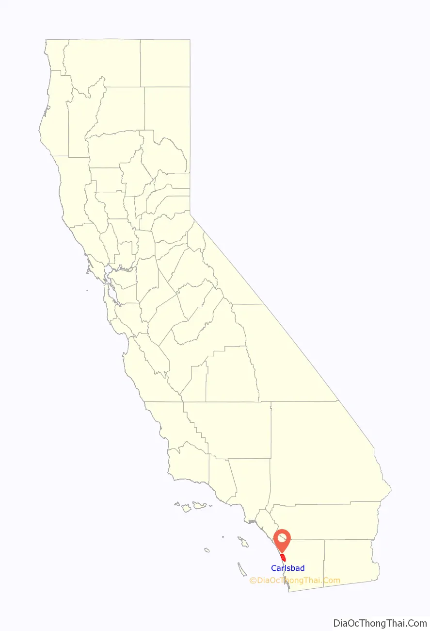
Carlsbad location map. Where is Carlsbad city?
History
Carlsbad’s history began with the Luiseño people (the Spanish name given to them because of their proximity to Mission San Luis Rey), as well as some Kumeyaay in the La Costa area. Nearly every reliable fresh water creek had at least one native village, including one called Palamai. The site is located just south of today’s Buena Vista Lagoon.
The first European land exploration of Alta California, the Spanish Portolá expedition of 1769, met native villagers while camped on Buena Vista Creek. Another Luiseño villages within today’s city of Carlsbad was a village at the mouth of the San Marcos Creek that the Kumeyaay called ‘Ajopunquile’. A Kumeyaay village that was visited by Portolá was Hakutl, in the Rancho Ponderosa area.
During the Mexican period, in 1842, the southern portion of Carlsbad was granted as Rancho Agua Hedionda to Juan María Marrón.
In the 1880s a former sailor named John A. Frazier dug a well in the area. He began offering his water at the train station and soon the whistle-stop became known as Frazier’s Station. A test done on a second fresh-water well discovered the water to be chemically similar to that found in some of the most renowned spas in the world, and the town was named after the famed spa in the Bohemian town of Karlsbad (now Karlovy Vary, Czech Republic).
To take advantage of the find, the Carlsbad Land and Mineral Water Company was formed by a German-born merchant from the Midwest named Gerhard Schutte together with Samuel Church Smith, D. D. Wadsworth and Henry Nelson. The naming of the town followed soon after, along with a major marketing campaign to attract visitors. The area experienced a period of growth, with homes and businesses sprouting up in the 1880s. Agricultural development of citrus fruits, avocados and olives soon changed the landscape. By the end of 1887, land prices fell throughout San Diego County. However, the community survived on the back of its fertile agricultural lands.
The site of John Frazier’s original well can still be found at Alt Karlsbad, a replica of a German Hanseatic house, located on Carlsbad Boulevard.
In 1952, Carlsbad was incorporated to avoid annexation by its neighbor, Oceanside.
The single-runway Palomar Airport opened in 1959 after County of San Diego officials decided to replace the Del Mar Airport. The airport was annexed to the City of Carlsbad in 1978 and renamed McClellan-Palomar Airport in 1982 after a local civic leader, Gerald McClellan.
The first modern skateboard park, Carlsbad Skatepark, was built in March 1976. It was located on the grounds of Carlsbad Raceway and was designed and built by inventors Jack Graham and John O’Malley. The skatepark was closed in 1979, leaving Del Mar Skate Ranch, approximately 20 minutes away, as the nearest skatepark for residents such as Tony Hawk. The site of the original Carlsbad Skatepark and Carlsbad Raceway was demolished in 2005 and is now an industrial park. However, two skateparks have since been developed.
In March 1999, Legoland California was opened. It was the first Legoland theme park outside of Europe and is currently operated by Merlin Entertainments. Merlin Entertainments owns 70 percent of the shares, and the remaining 30 percent is owned by the LEGO group and Kirkbi A/S.
Carlsbad is home to the nation’s largest desalination plant. Construction of the Carlsbad Desalination Plant at the Encina Power Station was completed in December 2015. The Encina Power Station is currently being demolished, despite efforts to preserve it as a historical landmark.
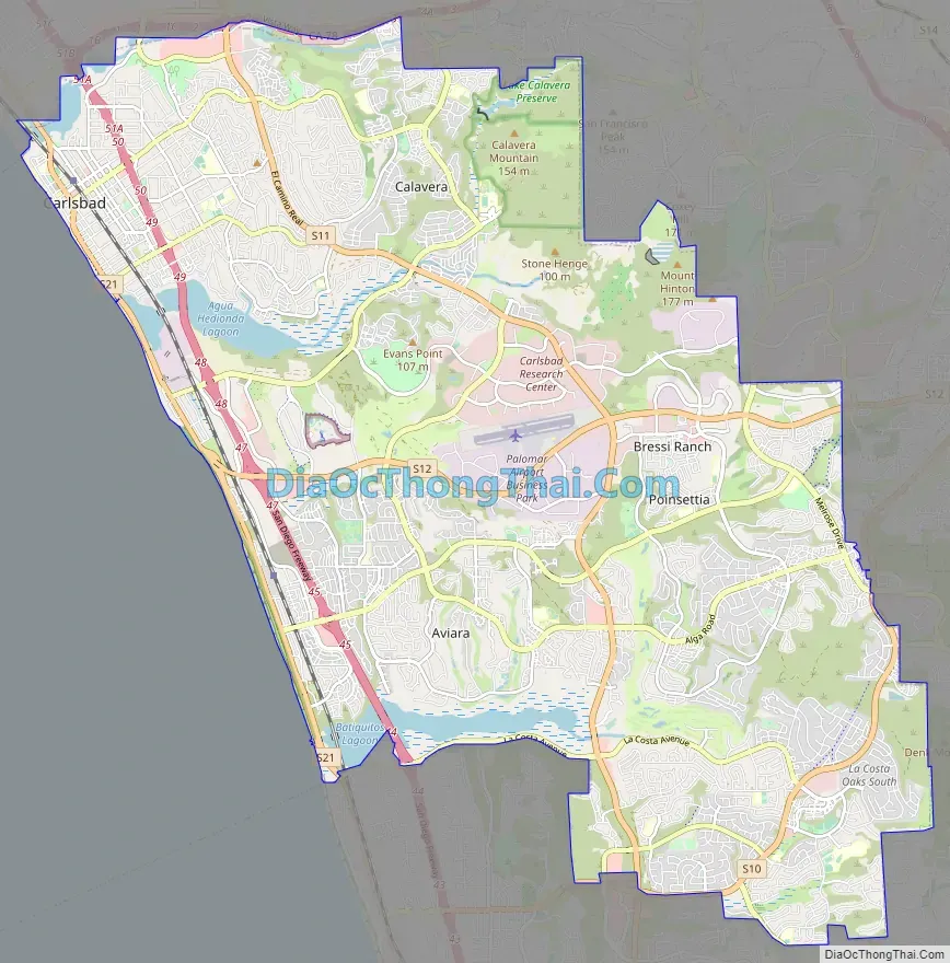
Carlsbad Road Map
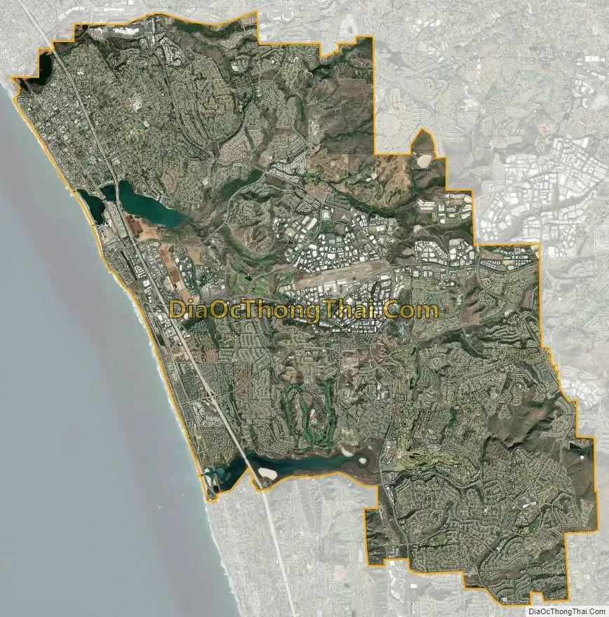
Carlsbad city Satellite Map
Geography
According to the United States Census Bureau, the city has a total area of 39.1 square miles (101 km) of which 37.7 square miles (98 km) are land and 1.4 square miles (3.6 km) are (3.55%) water, the majority of which is contained within three lagoons and one lake.
The northern area of the city is part of a tri-city area consisting of northern Carlsbad, southern Oceanside and western Vista.
The ocean-side cliffs fronting wide white-sand beaches and mild climate attract vacationers year-round.
Types of Households in Carlsbad city, California in 2015–2019. 56.6% was Married-couple households, 5.1% was cohabiting couple households, 13.6% male householder no spouse, 24.7% female householder no spouse.
Climate
Carlsbad has a semi-arid Mediterranean climate (Koppen classification BSh) and averages 263 sunny days per year. Winters are mild with periodic rain. Frost is rare along the coast, but sometimes occurs in inland valleys in December and January. Summer is almost rain free, but overcast and cool with fog off the Pacific. While most days have mild and pleasant temperatures, hot dry Santa Ana winds bring high temperatures on a few days each year, mostly in the fall.
Neighborhoods
For city planning and growth management purposes, Carlsbad is divided into four distinct quadrants.
The northwest quadrant of Carlsbad (ZIP code 92008) includes the downtown “Village”, “The Barrio”, and “Olde Carlsbad.” It was the first part of Carlsbad to be settled. Homes range from 1950s cottages and bungalows, 1960s ranch style houses, to elegant mansions on hills overlooking the ocean. It is also home to Hosp Grove Park, a grove of eucalyptus trees relatively untouched by development and now designated by the city for recreational use, in addition to the Buena Vista and Agua Hedionda Lagoons. It is located west of El Camino Real and north of Palomar Airport Road.
“The Barrio” area is near downtown Carlsbad bordered by Carlsbad Village Drive to the north, Tamarack Avenue to the south, Interstate 5 to the east and the railroad tracks to the west. It was settled by Latinos in the early 20th century. It is the site of the Centro de Aprendizaje, a Spanish division of the Carlsbad City Library.
This quadrant (ZIP code 92010) is located east of El Camino Real and north of Palomar Airport Road and consists mostly of single-family homes, with larger lots found in the older area known as Chestnut Hills and the newer developments around Calavera Hills.
The Northeast quadrant also contains the Lake Calavera Nature Preserve, a 110-acre space containing a 513-foot extinct volcano known as Mount Calavera. The preserve — notable for its small lake, wide dam, and mountain — was officially set aside in the 1990s as the surrounding land was being developed. The preserve is bordered on three sides by suburban single-family homes, and on one side by small farms and rural compounds. In 2012, Sage Creek High School was developed in the southwest corner of the preserve amid some controversy. Nature experts challenged the decision to construct the school on the preserve, but Carlsbad High School was reaching its capacity and there were few undeveloped areas that had sufficient space for an additional high school. Despite missing one of its original corners, the preserve still offers miles of hiking trails with ocean views.
The southeast quadrant (ZIP code 92009) is located east of El Camino Real and south of Palomar Airport Road and features several newer expensive master-planned communities set among hillsides, golf courses, Alga Norte Community Park and permanent open spaces. It includes Bressi Ranch and the La Costa neighborhoods of Rancho La Costa, La Costa Ridge, La Costa Oaks, La Costa Greens, La Costa Valley, and Rancho Carillo. In 1965, La Costa gave its name to the Gold Medal Golf Resort, La Costa Resort and Spa, now known as the Omni La Costa Resort and Spa. Residents here are served by the Carlsbad Unified School District, San Marcos Unified School District and the Encinitas Union School District.
This quadrant (ZIP code 92011) extends along the Pacific Ocean to the south of the center of Carlsbad. It includes the Aviara neighborhood, which is home to the Park Hyatt Aviara Resort. It is located west of El Camino Real and south of Palomar Airport Road.
See also
Map of California State and its subdivision:- Alameda
- Alpine
- Amador
- Butte
- Calaveras
- Colusa
- Contra Costa
- Del Norte
- El Dorado
- Fresno
- Glenn
- Humboldt
- Imperial
- Inyo
- Kern
- Kings
- Lake
- Lassen
- Los Angeles
- Madera
- Marin
- Mariposa
- Mendocino
- Merced
- Modoc
- Mono
- Monterey
- Napa
- Nevada
- Orange
- Placer
- Plumas
- Riverside
- Sacramento
- San Benito
- San Bernardino
- San Diego
- San Francisco
- San Joaquin
- San Luis Obispo
- San Mateo
- Santa Barbara
- Santa Clara
- Santa Cruz
- Shasta
- Sierra
- Siskiyou
- Solano
- Sonoma
- Stanislaus
- Sutter
- Tehama
- Trinity
- Tulare
- Tuolumne
- Ventura
- Yolo
- Yuba
- Alabama
- Alaska
- Arizona
- Arkansas
- California
- Colorado
- Connecticut
- Delaware
- District of Columbia
- Florida
- Georgia
- Hawaii
- Idaho
- Illinois
- Indiana
- Iowa
- Kansas
- Kentucky
- Louisiana
- Maine
- Maryland
- Massachusetts
- Michigan
- Minnesota
- Mississippi
- Missouri
- Montana
- Nebraska
- Nevada
- New Hampshire
- New Jersey
- New Mexico
- New York
- North Carolina
- North Dakota
- Ohio
- Oklahoma
- Oregon
- Pennsylvania
- Rhode Island
- South Carolina
- South Dakota
- Tennessee
- Texas
- Utah
- Vermont
- Virginia
- Washington
- West Virginia
- Wisconsin
- Wyoming


