North Miami Beach (commonly referred to as NMB) is a city in Miami-Dade County, Florida, United States. Originally named “Fulford-by-the-Sea” in 1926 after Captain William H. Fulford of the U.S. Coast Guard, the city was renamed “North Miami Beach” in 1931. The population was 43,676 at the 2020 census.
| Name: | North Miami Beach city |
|---|---|
| LSAD Code: | 25 |
| LSAD Description: | city (suffix) |
| State: | Florida |
| County: | Miami-Dade County |
| Incorporated: | June 15, 1931 |
| Elevation: | 10 ft (3 m) |
| Total Area: | 5.37 sq mi (13.91 km²) |
| Land Area: | 4.84 sq mi (12.55 km²) |
| Water Area: | 0.53 sq mi (1.36 km²) 6.43% |
| Total Population: | 43,676 |
| Population Density: | 9,016.52/sq mi (3,481.18/km²) |
| Area code: | 305, 786 |
| FIPS code: | 1249475 |
| GNISfeature ID: | 287838 |
| Website: | www.citynmb.com |
Online Interactive Map
Click on ![]() to view map in "full screen" mode.
to view map in "full screen" mode.
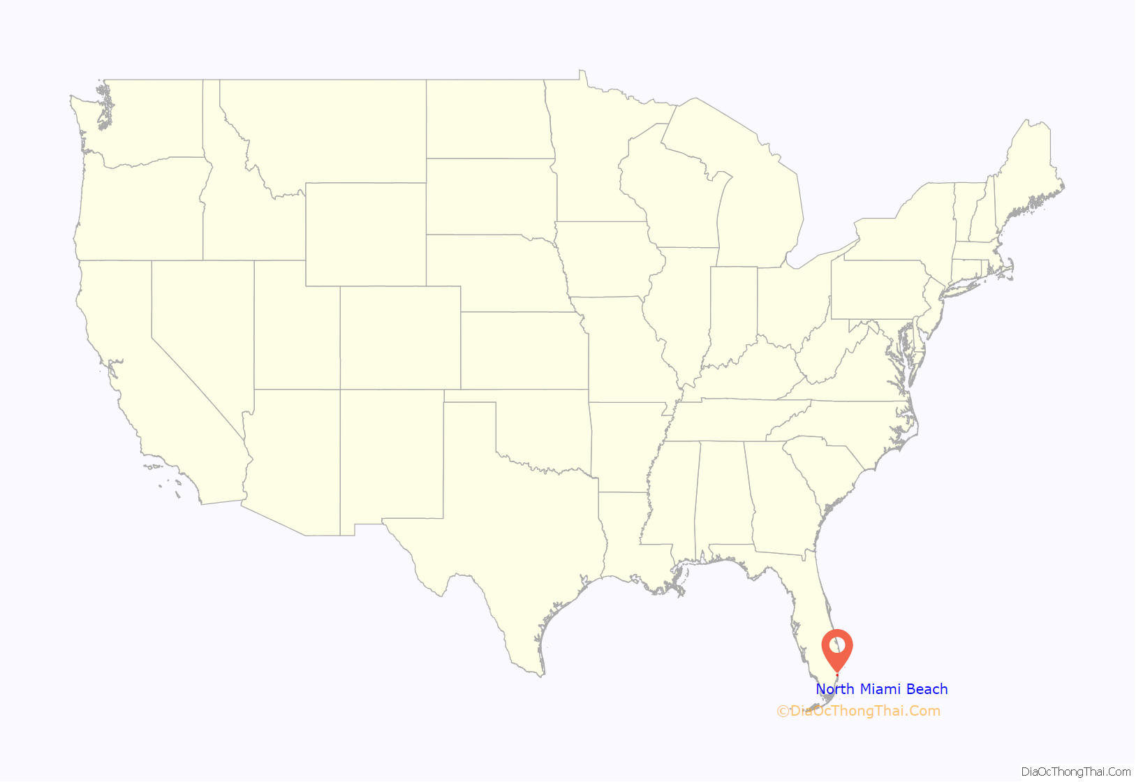
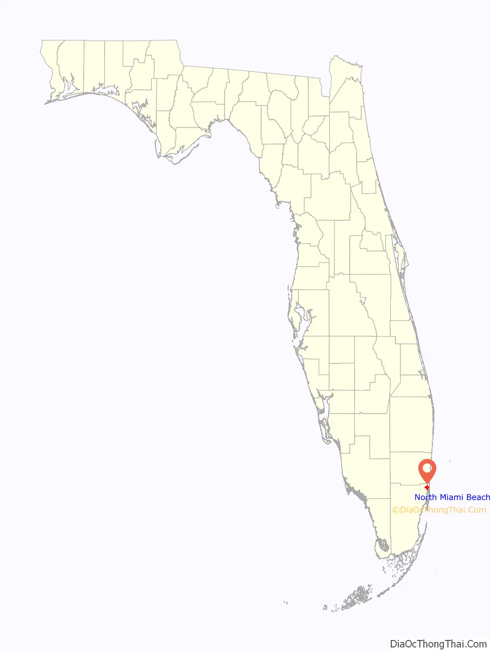
North Miami Beach location map. Where is North Miami Beach city?
History
In the 1920s, Carl G. Fisher built an all-wooden racetrack with stands for 12,000 spectators, known as the Fulford–Miami Speedway. This event, held on February 22, 1926, dubbed the Carl G. Fisher Cup Race, was a forerunner to the auto races at Sebring and Daytona. In September 1926, after just one race, the track was destroyed by the 1926 Miami Hurricane.
The hurricane of 1926 essentially ended the South Florida real estate boom, and in an effort to alleviate their losses and the damage to the city, local residents came together as the Town of Fulford. In 1927, it was incorporated as the City of Fulford.
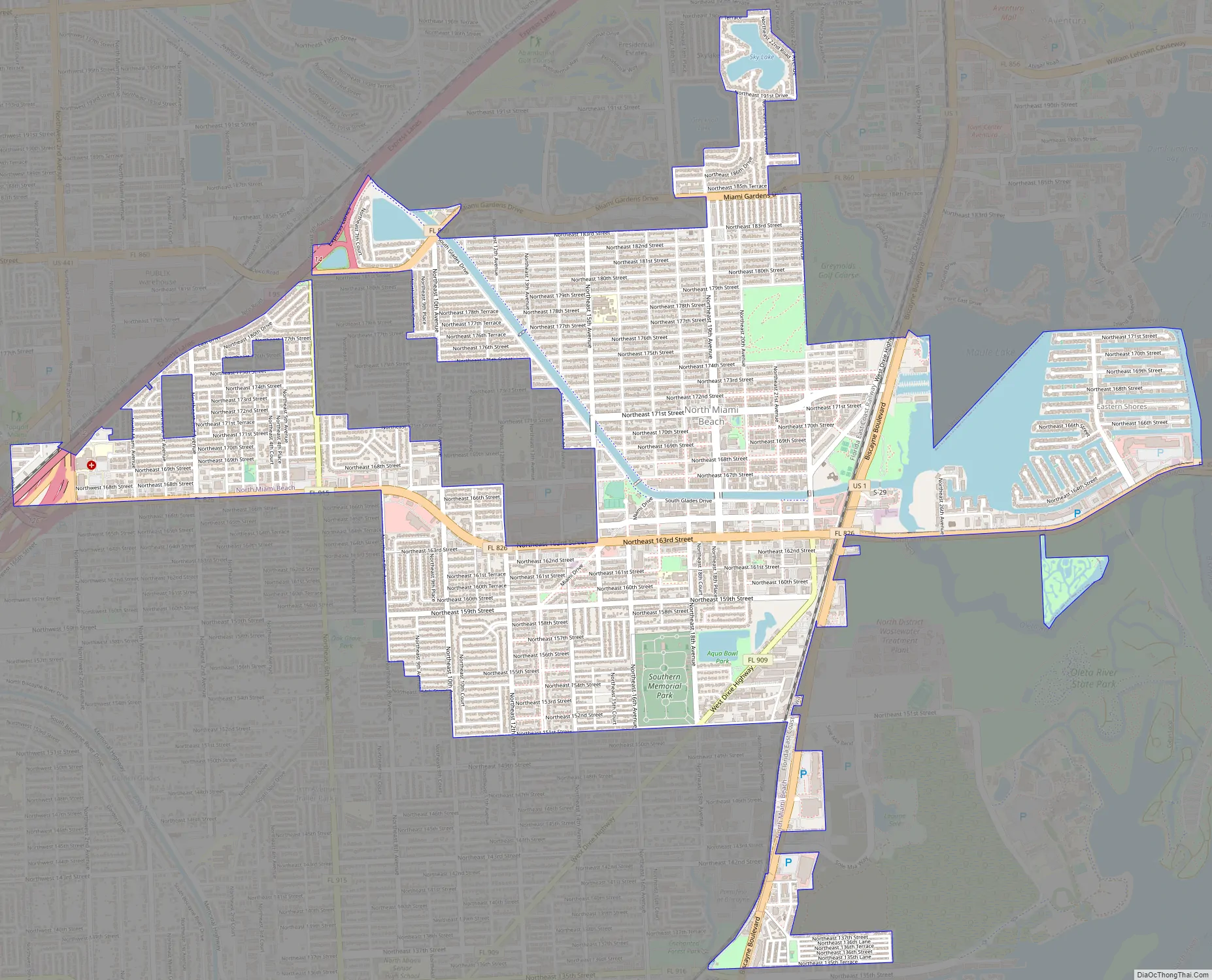
North Miami Beach Road Map
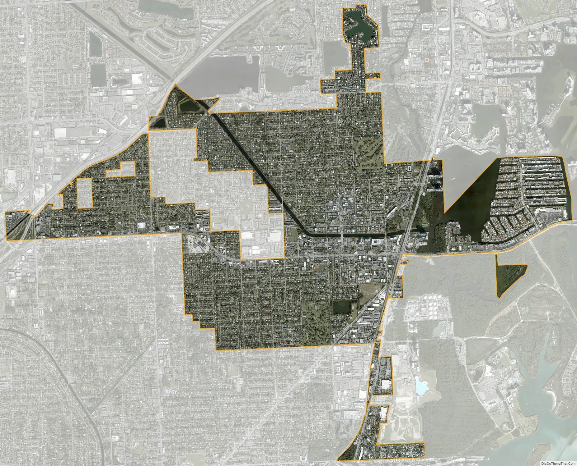
North Miami Beach city Satellite Map
Geography
North Miami Beach is located in northeastern Miami-Dade County at 25°55′49″N 80°10′1″W / 25.93028°N 80.16694°W / 25.93028; -80.16694. It is bordered to the southeast by the city of North Miami, to the southwest by unincorporated Golden Glades, to the west by the city of Miami Gardens, to the north by unincorporated Ojus, to the northeast by the city of Aventura, and to the east across the Intracoastal Waterway by the city of Sunny Isles Beach.
U.S. Route 1 (Biscayne Boulevard) runs through the east side of the city, leading south 11 miles (18 km) to downtown Miami and north 14 miles (23 km) to Fort Lauderdale. Interstate 95 runs along the northwest border of the city, with access from Exit 12.
According to the United States Census Bureau, the city has a total area of 5.37 square miles (13.9 km). 4.4 square miles (11 km) of it are land and 0.53 square miles (1.4 km) of it (9.78%) are water.
Although the North Miami Beach boundaries once stretched to the Atlantic Ocean, the city no longer has any beaches within its limits. They are now a short distance away, within the city of Sunny Isles Beach across the Intracoastal Waterway.
Climate
Surrounding areas
- Miami Gardens, Ives Estates, Ojus, Aventura
- Miami Gardens Sunny Isles Beach
- Miami Gardens, Unincorporated Miami-Dade County, Golden Glades Ojus, Aventura, Sunny Isles Beach
- Golden Glades North Miami
- Golden Glades, North Miami
See also
Map of Florida State and its subdivision:- Alachua
- Baker
- Bay
- Bradford
- Brevard
- Broward
- Calhoun
- Charlotte
- Citrus
- Clay
- Collier
- Columbia
- Desoto
- Dixie
- Duval
- Escambia
- Flagler
- Franklin
- Gadsden
- Gilchrist
- Glades
- Gulf
- Hamilton
- Hardee
- Hendry
- Hernando
- Highlands
- Hillsborough
- Holmes
- Indian River
- Jackson
- Jefferson
- Lafayette
- Lake
- Lee
- Leon
- Levy
- Liberty
- Madison
- Manatee
- Marion
- Martin
- Miami-Dade
- Monroe
- Nassau
- Okaloosa
- Okeechobee
- Orange
- Osceola
- Palm Beach
- Pasco
- Pinellas
- Polk
- Putnam
- Saint Johns
- Saint Lucie
- Santa Rosa
- Sarasota
- Seminole
- Sumter
- Suwannee
- Taylor
- Union
- Volusia
- Wakulla
- Walton
- Washington
- Alabama
- Alaska
- Arizona
- Arkansas
- California
- Colorado
- Connecticut
- Delaware
- District of Columbia
- Florida
- Georgia
- Hawaii
- Idaho
- Illinois
- Indiana
- Iowa
- Kansas
- Kentucky
- Louisiana
- Maine
- Maryland
- Massachusetts
- Michigan
- Minnesota
- Mississippi
- Missouri
- Montana
- Nebraska
- Nevada
- New Hampshire
- New Jersey
- New Mexico
- New York
- North Carolina
- North Dakota
- Ohio
- Oklahoma
- Oregon
- Pennsylvania
- Rhode Island
- South Carolina
- South Dakota
- Tennessee
- Texas
- Utah
- Vermont
- Virginia
- Washington
- West Virginia
- Wisconsin
- Wyoming


