Ruskin is an unincorporated census-designated place in Hillsborough County, Florida. The area was part of the chiefdom of the Uzita at the time of the Hernando de Soto expedition in 1539. The community was founded August 7, 1908, on the shores of the Little Manatee River. It was developed by Dr. George McAnelly Miller, an attorney and professor at Ruskin College in Trenton, Missouri, and Addie Dickman Miller. It is named after the essayist and social critic John Ruskin. Miller established the short-lived Ruskin College. It was one of the Ruskin Colleges.
| Name: | Ruskin CDP |
|---|---|
| LSAD Code: | 57 |
| LSAD Description: | CDP (suffix) |
| State: | Florida |
| County: | Hillsborough County |
| Elevation: | 3 ft (1 m) |
| Total Area: | 19.53 sq mi (50.59 km²) |
| Land Area: | 18.19 sq mi (47.11 km²) |
| Water Area: | 1.34 sq mi (3.48 km²) |
| Total Population: | 28,620 |
| Population Density: | 1,573.31/sq mi (607.46/km²) |
| Area code: | 813 |
| FIPS code: | 1262275 |
| GNISfeature ID: | 0290065 |
Online Interactive Map
Click on ![]() to view map in "full screen" mode.
to view map in "full screen" mode.
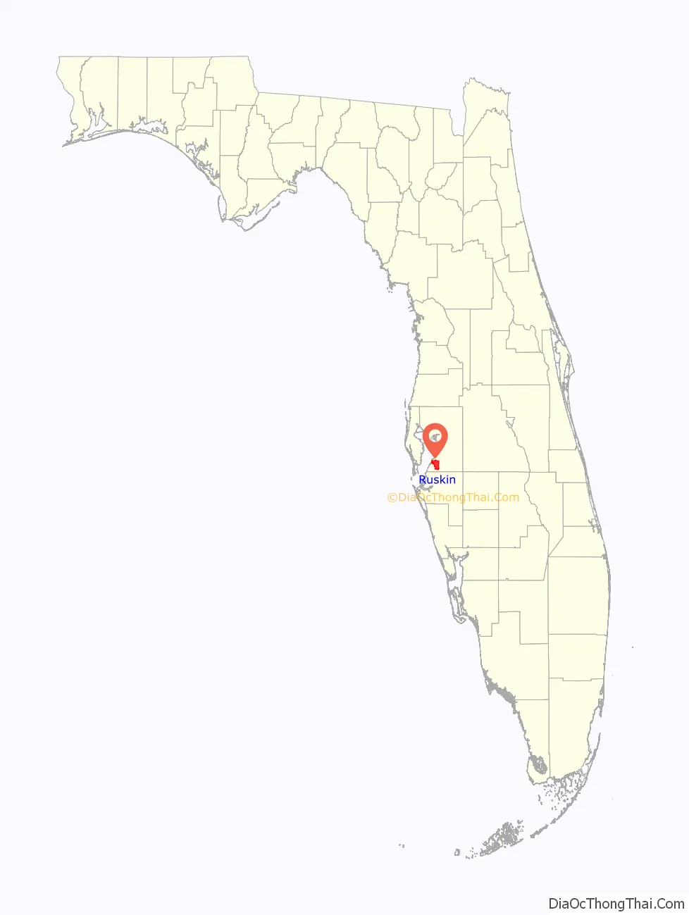
Ruskin location map. Where is Ruskin CDP?
History
The town and college were named after the English writer and social reformist John Ruskin. Ruskin, a utopian, founded the Guild of St George, a celebration of workmanship that underpinned the Arts and Crafts movement of William Morris. Ruskin was a passionate educator.
In 1907, Dr. George McAnelly Miller, a former Chicago prosecuting attorney and professor, and former president of Ruskin College in Trenton, Missouri, relocated his family to the area, along with his brother-in-law Albert Peter Dickman’s family. They purchased land and started to set up homes, a sawmill, and a school. Addie Dickman Miller, Dr. Miller’s wife, founded a post office on August 7, 1908. This day is recognized as the official founding day of the town. The Ruskin Commongood Society platted Ruskin on February 19, 1910, and filed the plat on March 9, 1910, in the Hillsborough County Court House, with lots for the college, the business district, two parks, and for the founding families, with only white people allowed to own or lease land in the community. Albert Dickman’s house, finished in 1910, on the banks of the Little Manatee River, is one of the few structures left standing from the founding of Ruskin.
The Millers began a new Ruskin College in 1910, with Dr. Miller serving as president and Adeline Miller serving as Vice President. Continuing with the college’s former practices, students worked a portion of each day as part of their education and as a way to pay for tuition and board. It offered three years of preparatory classes, after which students could attend the college, taking classes in art, drama, language, literature, music, shorthand, social sciences, and speech. At the peak of the college’s prosperity it had 160 students..
By 1913, the community had a cooperative general store, a canning factory, a telephone system, an electric plant supplying electricity to both public and private buildings, a weekly paper, and regular boat freight and passenger service to Tampa. With the onset of World War I, most students went to the war in Europe and the college closed its doors. In 1918, a fire destroyed the college, sparing only the Millers’ house. Dr. Miller died in August 1919.
At this time U.S. Route 41 was only a 9-foot-wide (2.7 m) shell road paid for by a $30,000 local bond issue (equivalent to $354,000 in 2021). Because of the growing importance of truck farming, these roads and others were built to facilitate the transportation of produce to local markets throughout the 1920s. The railroad track connected Ruskin to the Seaboard Air Line Railroad line in 1913. On the eve of the college’s demise in 1918, Ruskin had a population of 200 Ruskinites, as they are called. The majority of people appeared to have been truck growers. These residents supported a sawmill, a turpentine still, a syrup factory, a blacksmith, a newspaper, a lawyer, two carpenters, and three general stores. Rachel W. Billings served as postmaster and as the Universalist minister. With this foundation, it is not surprising that even with the destruction of the college the colony survived.
In 1925, Ruskin’s population remained at 200. It had six hotels, two sawmills, one turpentine still, a public library, the Ruskin Telephone Company, four groceries, one garage, a well driller, two restaurants, a dry goods dealer, a carpenter, and a number of fruit and truck growers. Some of the fields had been cultivated, and tomatoes, cabbages, onions and other crops were being raised. There was a nursery established for ornamentals. Thousands of palms were ready for market, and streets were being graded in certain portions of the town that lay off the highway. The community’s social life included four or five clubs organized by women, ranging from the Woman’s Twentieth Century Club to the League of Women Voters. A new school was erected, as well as a church. With the road developments auto service was provided to Brandon, Tampa, and Wimauma.
In 1930 Ruskin’s population had reached 709, consisting of 395 males and 314 females. Despite the deed restrictions against African Americans owning or leasing property, 140 black people resided in Ruskin. The rest of the population was white, of whom 514 were native and 52 were foreign-born. Three companies operated in Ruskin in 1935 despite the Depression and a drop to 600 residents: Florida Power & Light Company; Ruskin Telephone, Electric Light and Power Company, Inc.; and Ruskin Trailer Company.
Because of its agricultural roots, the town weathered the Depression. The soil of Ruskin farms is especially adapted to growing tomatoes. There is a large area of muck land underlaid with marl in this region. The marl base allows irrigation of crops without loss of fertilizer, as the marl prevents the fertilizer from washing too deep into the soil. Ruskin is favored with numerous artesian wells. Due to the rapid growth of tomato culture and a cooperative arrangement among Ruskin farmers, the town was again a thriving community. It had a canning plant which employed 65 workers, a community hall, and a modern schoolhouse. As part of an attempt to attract visitors to Ruskin and to celebrate the area’s agricultural richness, the community instituted the annual springtime Ruskin Tomato Festival in 1935 where vegetables were displayed and the community’s most popular woman was voted as queen. The festival still takes place every year in May.
With many Ruskin residents working in Tampa during World War II, people from Tampa began hearing of the benefits of the rural community. Shortly after the war, Ruskin slowly became more and more suburban as people not related to the agricultural business moved into the community.
In 1960, Ruskin was still very rural. Agriculture dominated Ruskin throughout the 1970s, but its influence began to wane. The greater Ruskin area’s population reached 17,000 by 1975, many of whom were not farmers, but suburbanites. By 1982, Ruskin produced approximately 3,000 acres (1,200 ha) of tomatoes a year, and one of the world’s largest tomato-packing houses operated in nearby Apollo Beach. However, flower farms, phosphate, real estate, and tropical fish farms also became important economic engines for Ruskin that began encroaching upon farmland. Despite this, farmers grew approximately $15 million worth of produce yearly in the late 1980s.
Poor crop yields in the mid- to late 1980s drove some farmers to the wall. Many borrowed money, sometimes as much as $500,000, against their land to plant their crops. Consequently, many farmers were forced out of business, and others chose to leave farming forever. Due to the impact of the North American Free Trade Agreement in the 1990s which allowed Mexican tomatoes to flood the U.S. market and with ever-increasing water restrictions, tomato acreage continued to decline. Less than half the number of acres planted with tomatoes in the early 1990s were planted in 1997. The housing boom of the first decade of the 21st century turned most of the tomato and orange plantations into new housing development, bringing thousands of new inhabitants to the area.
The South County Coalition for Community Concerns (SCCCC) established in 1984 was a Ruskin-based Coalition comprising public and private health and human service organizations, government agencies, schools, churches and concerned citizens from South County. The history of the SCCCC (1980-2002) outlines, programs, celebrations and mutual support to bring a better quality of life to people of rural south Hillsborough County.
By 1990, changes to the downtown had occurred. The end of the traditional Ruskin Days parade (due to rising costs) and a great fire that wiped out the popular Thriftway supermarket and adjacent furniture, hardware and MC Topps department stores changed the landscape of the town center.
At present, Ruskin continues to grow with new commerce and housing developments. U.S. Route 41 is now a four-lane road connecting Ruskin to Tampa, as does Interstate 75, which has an exit at Ruskin. It had a very active chamber of commerce until 2011 when it merged with the Apollo Beach Chamber to become the South Shore Chamber of Commerce and moved from Ruskin to Apollo Beach.
Ruskin is the seat of the South Hillsborough County Government Center and has a branch of the Hillsborough County Public Library System. In 2009, the Dickman family donated the land where the new Ruskin Campus of Hillsborough Community College was erected, across the street from Earl J. Lennard High School.
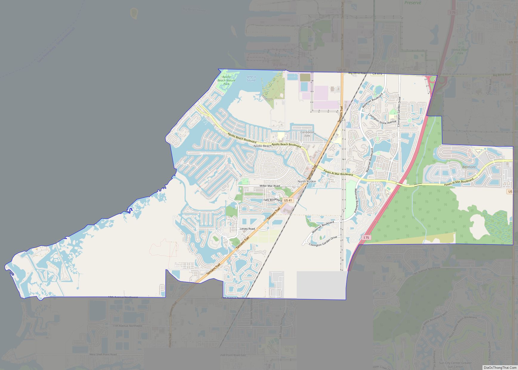
Ruskin Road Map
Ruskin city Satellite Map
Geography
Ruskin is located in south-central Hillsborough County, on the north side of the Little Manatee River. It is bordered to the north by Apollo Beach and to the east by Sun City Center. U.S. Route 41 passes through the center of town, leading north 10 miles (16 km) to Gibsonton and southwest 20 miles (32 km) to Bradenton. Interstate 75 runs along the eastern edge of Ruskin, with access from Exit 240 (State Road 674/College Avenue). I-75 leads north 16 miles (26 km) to Brandon and south 30 miles (48 km) to Sarasota. Downtown Tampa is 24 miles (39 km) to the north via I-75 and the Selmon Expressway.
According to the United States Census Bureau, the Ruskin CDP has a total area of 19.5 square miles (50.6 km), of which 18.0 square miles (46.7 km) are land and 1.5 square miles (3.9 km), or 7.80%, are water.
See also
Map of Florida State and its subdivision:- Alachua
- Baker
- Bay
- Bradford
- Brevard
- Broward
- Calhoun
- Charlotte
- Citrus
- Clay
- Collier
- Columbia
- Desoto
- Dixie
- Duval
- Escambia
- Flagler
- Franklin
- Gadsden
- Gilchrist
- Glades
- Gulf
- Hamilton
- Hardee
- Hendry
- Hernando
- Highlands
- Hillsborough
- Holmes
- Indian River
- Jackson
- Jefferson
- Lafayette
- Lake
- Lee
- Leon
- Levy
- Liberty
- Madison
- Manatee
- Marion
- Martin
- Miami-Dade
- Monroe
- Nassau
- Okaloosa
- Okeechobee
- Orange
- Osceola
- Palm Beach
- Pasco
- Pinellas
- Polk
- Putnam
- Saint Johns
- Saint Lucie
- Santa Rosa
- Sarasota
- Seminole
- Sumter
- Suwannee
- Taylor
- Union
- Volusia
- Wakulla
- Walton
- Washington
- Alabama
- Alaska
- Arizona
- Arkansas
- California
- Colorado
- Connecticut
- Delaware
- District of Columbia
- Florida
- Georgia
- Hawaii
- Idaho
- Illinois
- Indiana
- Iowa
- Kansas
- Kentucky
- Louisiana
- Maine
- Maryland
- Massachusetts
- Michigan
- Minnesota
- Mississippi
- Missouri
- Montana
- Nebraska
- Nevada
- New Hampshire
- New Jersey
- New Mexico
- New York
- North Carolina
- North Dakota
- Ohio
- Oklahoma
- Oregon
- Pennsylvania
- Rhode Island
- South Carolina
- South Dakota
- Tennessee
- Texas
- Utah
- Vermont
- Virginia
- Washington
- West Virginia
- Wisconsin
- Wyoming

