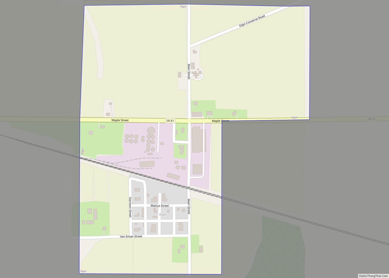
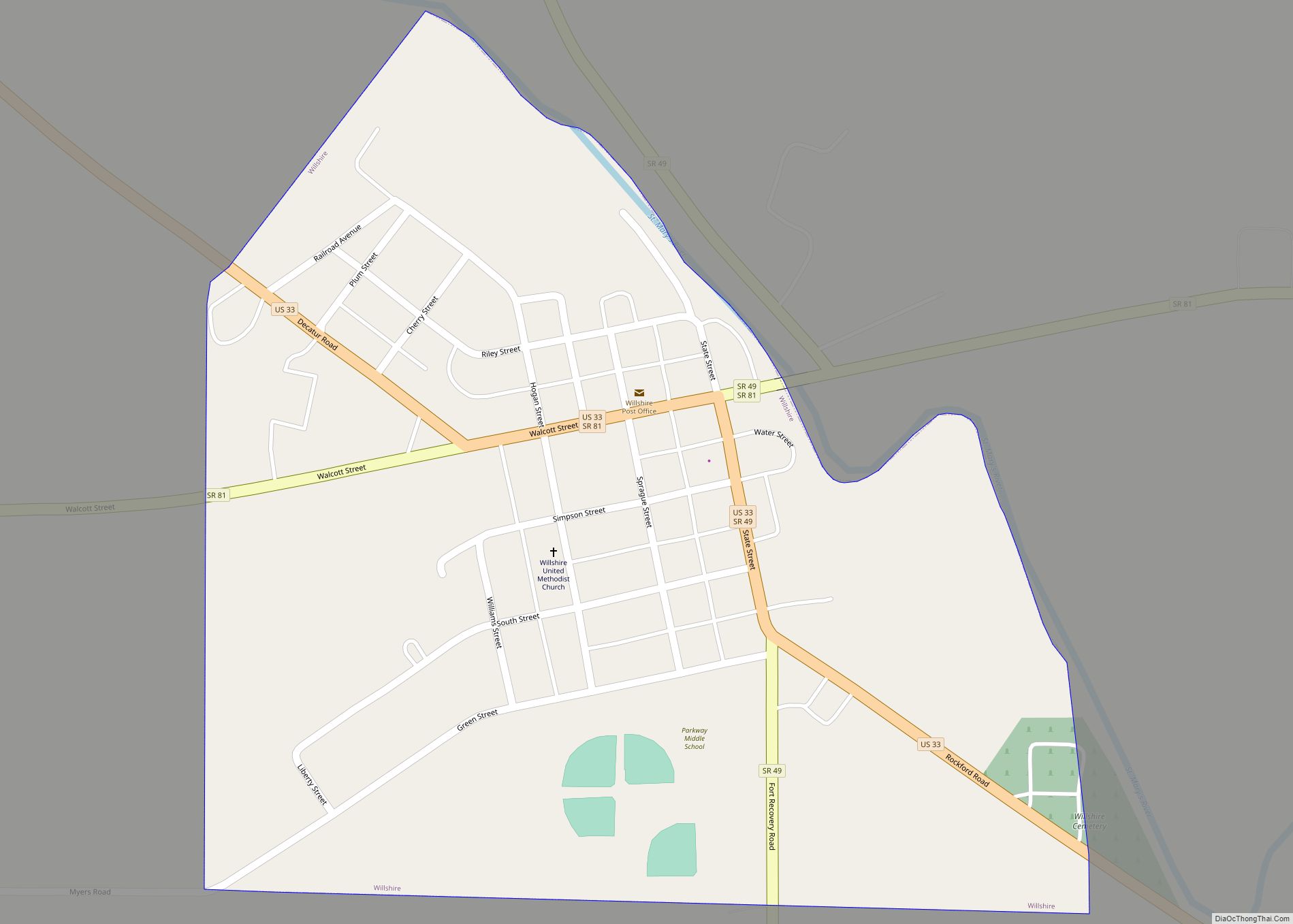
Willshire is a village in Van Wert County, Ohio, United States. The population was 397 at the 2010 census. It is included within the Van Wert, Ohio Micropolitan Statistical Area.
Willshire is located 0.5 mi (0.8 km) from the Ohio/Indiana State line. St. Mary’s River flows along the east edge of village.
| Name: | Willshire village |
|---|---|
| LSAD Code: | 47 |
| LSAD Description: | village (suffix) |
| State: | Ohio |
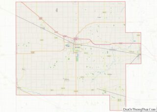
| County: | Van Wert County |
| Total Area: | 0.35 sq mi (0.92 km²) |
| Land Area: | 0.35 sq mi (0.91 km²) |
| Water Area: | 0.00 sq mi (0.00 km²) |
| Total Population: | 405 |
| Population Density: | 1,147.31/sq mi (442.99/km²) |
| ZIP code: | 45898 |
| Area code: | 419 |
| FIPS code: | 3985736 |
| GNISfeature ID: | 2399703 |
Online Interactive Map
Click on ![]() to view map in "full screen" mode.
to view map in "full screen" mode.
Willshire location map. Where is Willshire village?


History
Willshire was founded by Captain James Riley in 1822, and is named for the English man who saved him while he was a captive in Africa, William Willshire. A post office has been in operation at Willshire since 1822. Willshire served as the first county seat for Van Wert County.
Willshire Road Map

Willshire city Satellite Map

Geography
According to the United States Census Bureau, the village has a total area of 0.37 square miles (0.96 km), all land.
See also
Map of Ohio State and its subdivision:- Adams
- Allen
- Ashland
- Ashtabula
- Athens
- Auglaize
- Belmont
- Brown
- Butler
- Carroll
- Champaign
- Clark
- Clermont
- Clinton
- Columbiana
- Coshocton
- Crawford
- Cuyahoga
- Darke
- Defiance
- Delaware
- Erie
- Fairfield
- Fayette
- Franklin
- Fulton
- Gallia
- Geauga
- Greene
- Guernsey
- Hamilton
- Hancock
- Hardin
- Harrison
- Henry
- Highland
- Hocking
- Holmes
- Huron
- Jackson
- Jefferson
- Knox
- Lake
- Lake Erie
- Lawrence
- Licking
- Logan
- Lorain
- Lucas
- Madison
- Mahoning
- Marion
- Medina
- Meigs
- Mercer
- Miami
- Monroe
- Montgomery
- Morgan
- Morrow
- Muskingum
- Noble
- Ottawa
- Paulding
- Perry
- Pickaway
- Pike
- Portage
- Preble
- Putnam
- Richland
- Ross
- Sandusky
- Scioto
- Seneca
- Shelby
- Stark
- Summit
- Trumbull
- Tuscarawas
- Union
- Van Wert
- Vinton
- Warren
- Washington
- Wayne
- Williams
- Wood
- Wyandot
- Alabama
- Alaska
- Arizona
- Arkansas
- California
- Colorado
- Connecticut
- Delaware
- District of Columbia
- Florida
- Georgia
- Hawaii
- Idaho
- Illinois
- Indiana
- Iowa
- Kansas
- Kentucky
- Louisiana
- Maine
- Maryland
- Massachusetts
- Michigan
- Minnesota
- Mississippi
- Missouri
- Montana
- Nebraska
- Nevada
- New Hampshire
- New Jersey
- New Mexico
- New York
- North Carolina
- North Dakota
- Ohio
- Oklahoma
- Oregon
- Pennsylvania
- Rhode Island
- South Carolina
- South Dakota
- Tennessee
- Texas
- Utah
- Vermont
- Virginia
- Washington
- West Virginia
- Wisconsin
- Wyoming