Canyon Lake is a city and gated community on Canyon Lake reservoir, located in the Inland Empire, Riverside County, California, United States. Canyon Lake began as a master-planned community developed by Corona Land Company in 1968. The City of Canyon Lake was incorporated on December 1, 1990. Railroad Canyon Dam was built in 1927, and impounds the San Jacinto River to fill the reservoir, which covers 383 acres (1.55 km) and has 14.9 miles (24.0 km) of shoreline.
| Name: | Canyon Lake city |
|---|---|
| LSAD Code: | 25 |
| LSAD Description: | city (suffix) |
| State: | California |
| County: | Riverside County |
| Incorporated: | December 1, 1990 |
| Elevation: | 1,384 ft (422 m) |
| Total Area: | 4.66 sq mi (12.07 km²) |
| Land Area: | 3.92 sq mi (10.15 km²) |
| Water Area: | 0.74 sq mi (1.92 km²) 15.92% |
| Total Population: | 11,082 |
| Population Density: | 2,827.76/sq mi (1,091.72/km²) |
| ZIP code: | 92587 |
| Area code: | 951 |
| FIPS code: | 0610928 |
| Website: | www.cityofcanyonlake.org |
Online Interactive Map
Click on ![]() to view map in "full screen" mode.
to view map in "full screen" mode.
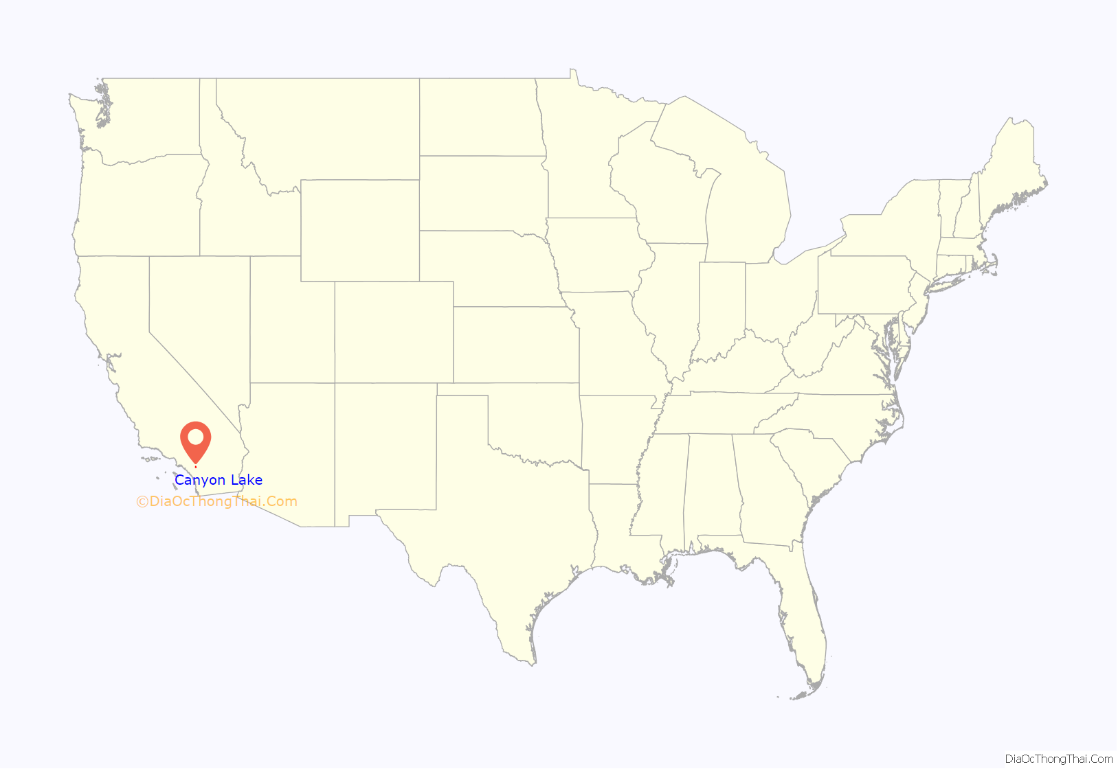
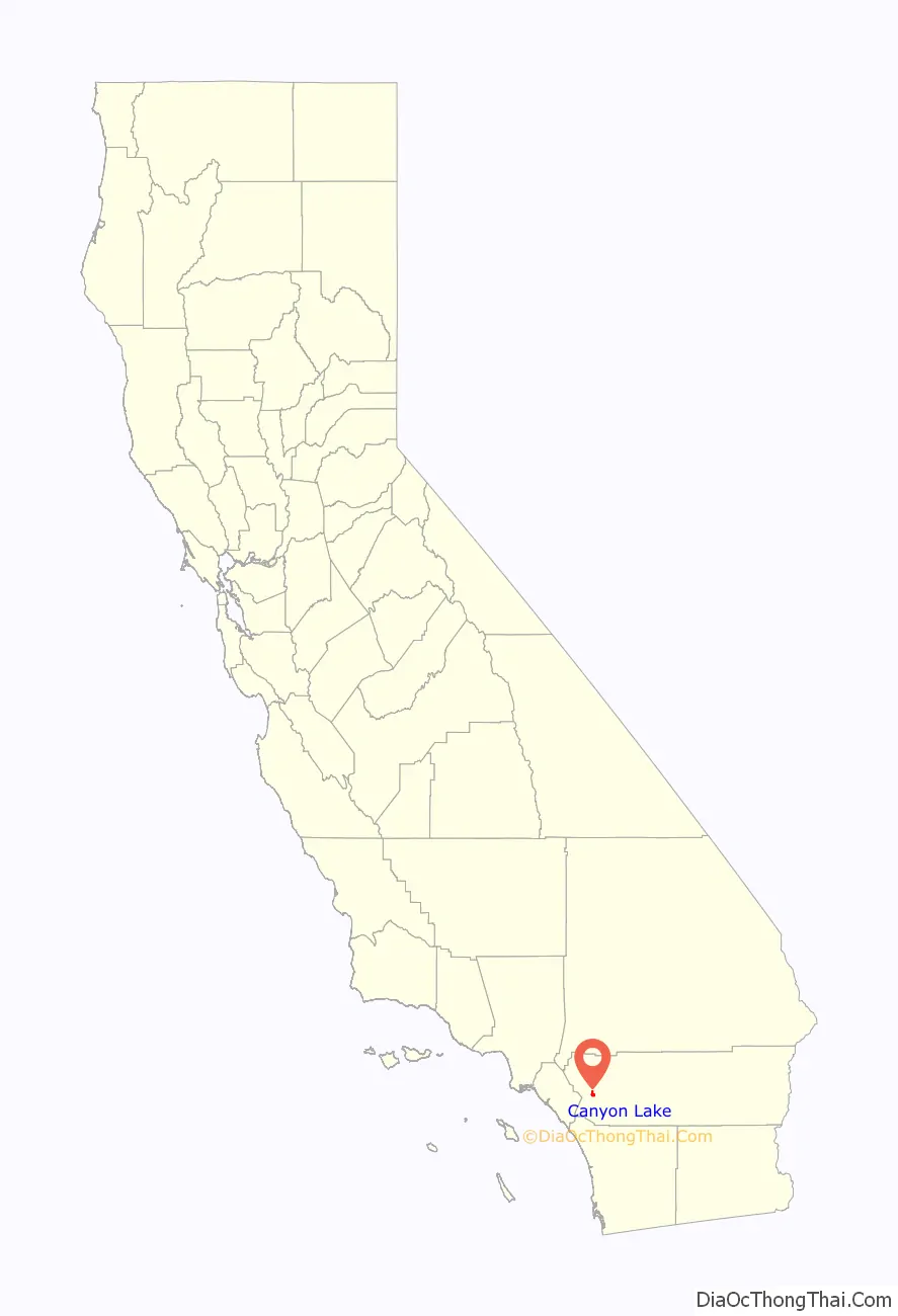
Canyon Lake location map. Where is Canyon Lake city?
History
Etymology
The city of Canyon Lake is named after the reservoir it is built around. Initially, the reservoir was known as Railroad Canyon Reservoir, or Railroad Canyon Lake, but now the reservoir and the community are referred to by the shortened form, Canyon Lake.
Early history
In 1882 the California Southern Railroad built a line from Perris to Elsinore along the east side of the San Jacinto River. The Santa Fe Railroad bought the line and joined it with their line in San Bernardino. Floods in 1884, 1916, and 1927 washed out the tracks, and the Santa Fe Railroad decided to abandon the line. Soon after the last flood, the Temescal Water Company bought the railroad right-of-way, as well as 1,000 acres (400 ha) from Henry Evans, a rancher, and another land from B.T. Kuert. Those were the two parcels that make up most of Canyon Lake today.
Construction started in 1927 to build a dam across the river to store water. It was finished in 1929. Railroad Canyon Reservoir, when built, was one of the largest freshwater lakes for fishing, hunting, and camping in Southern California. The reservoir and the surrounding area were leased as a concession from Temescal Water Company as a recreational area under the operation of the George D. Evans family from 1937 until after World War II. After the war Ray and Alpha Schekel, along with John and Darleen Kirkland, operated the resort until 1949 when the lake was drained for repairs to the floodgates.
Community development
In 1968 the Corona Land Development Company developed the new community.
Canyon Lake began as a master-planned community developed by Corona Land Company in 1968, consisting of 4,801 lots. All but a few roads within the city are privately held and maintained by the Canyon Lake Property Owners Association. The 3 entrances to the Canyon Lake POA areas are gated and guarded, accessible by residents and authorized guests.
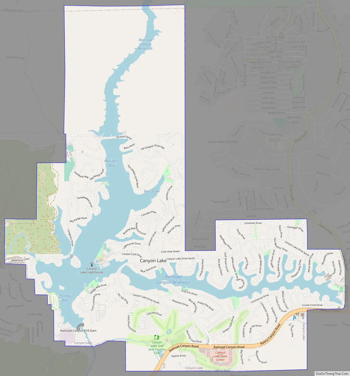
Canyon Lake Road Map
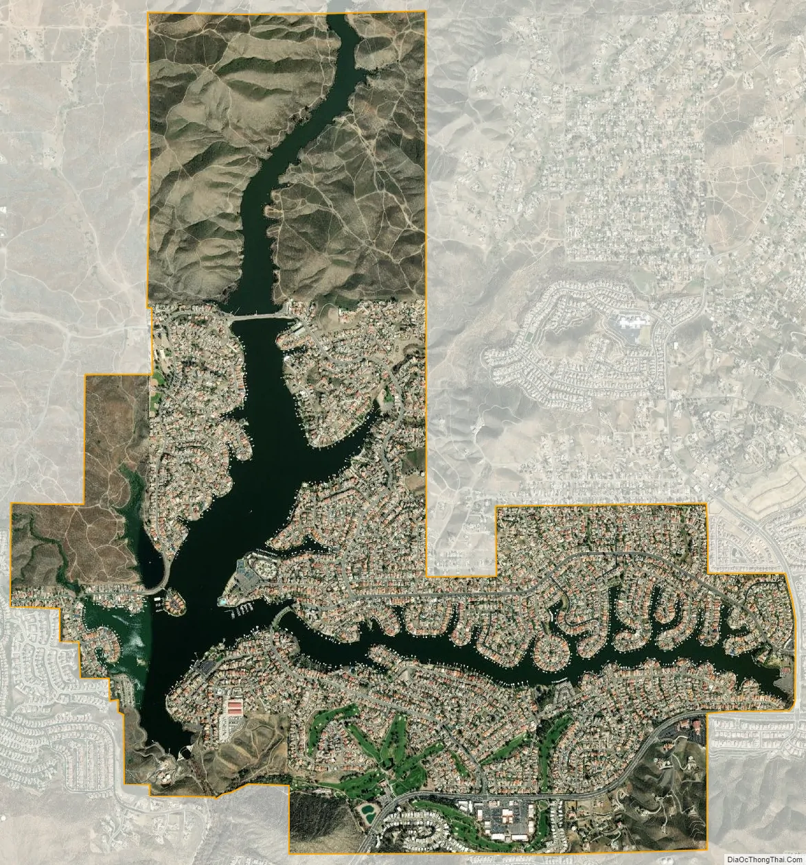
Canyon Lake city Satellite Map
Geography
The city of Canyon Lake is located east of Lake Elsinore and Interstate 15, in the southern foothills of the Temescal Mountains. The mountain range is on the western edge of the Perris Block and east of the Elsinore Fault Zone.
According to the United States Census Bureau, the city has a total area of 4.7 square miles (12 km) or 2,017 acres (816 ha), of which, 3.9 square miles (10 km) of it is land and 0.7 square miles (1.8 km) of it (15.92%) is water. The lake has 14.9 miles (24.0 km) of shoreline.
Reservoir
The community is named for Canyon Lake reservoir, also known as the Railroad Canyon Reservoir, which it surrounds. The reservoir, created in 1928 with the construction of the Railroad Canyon Dam, covers approximately 525 acres (212 ha), has 14.9 miles (24.0 km) of shoreline, and has a storage capacity of 11,586 acre⋅ft (14,291,000 m). It is owned and operated by the Elsinore Valley Municipal Water District.
The reservoir is supplied by stormwater runoff from the San Jacinto River and Salt Creek. Water from the reservoir feeds the Canyon Lake Water Treatment Plant, which provides approximately 10% of the domestic water supply in the Lake Elsinore/Canyon Lake area.
See also
Map of California State and its subdivision:- Alameda
- Alpine
- Amador
- Butte
- Calaveras
- Colusa
- Contra Costa
- Del Norte
- El Dorado
- Fresno
- Glenn
- Humboldt
- Imperial
- Inyo
- Kern
- Kings
- Lake
- Lassen
- Los Angeles
- Madera
- Marin
- Mariposa
- Mendocino
- Merced
- Modoc
- Mono
- Monterey
- Napa
- Nevada
- Orange
- Placer
- Plumas
- Riverside
- Sacramento
- San Benito
- San Bernardino
- San Diego
- San Francisco
- San Joaquin
- San Luis Obispo
- San Mateo
- Santa Barbara
- Santa Clara
- Santa Cruz
- Shasta
- Sierra
- Siskiyou
- Solano
- Sonoma
- Stanislaus
- Sutter
- Tehama
- Trinity
- Tulare
- Tuolumne
- Ventura
- Yolo
- Yuba
- Alabama
- Alaska
- Arizona
- Arkansas
- California
- Colorado
- Connecticut
- Delaware
- District of Columbia
- Florida
- Georgia
- Hawaii
- Idaho
- Illinois
- Indiana
- Iowa
- Kansas
- Kentucky
- Louisiana
- Maine
- Maryland
- Massachusetts
- Michigan
- Minnesota
- Mississippi
- Missouri
- Montana
- Nebraska
- Nevada
- New Hampshire
- New Jersey
- New Mexico
- New York
- North Carolina
- North Dakota
- Ohio
- Oklahoma
- Oregon
- Pennsylvania
- Rhode Island
- South Carolina
- South Dakota
- Tennessee
- Texas
- Utah
- Vermont
- Virginia
- Washington
- West Virginia
- Wisconsin
- Wyoming


