Blythe /ˈblaɪθ/ is a city in eastern Riverside County, California, United States. It is in the Palo Verde Valley of the Lower Colorado River Valley region, an agricultural area and part of the Colorado Desert along the Colorado River, approximately 224 miles (360 km) east of Los Angeles and 150 miles (240 km) west of Phoenix. Blythe was named after Thomas Henry Blythe, a San Francisco financier, who established primary water rights to the Colorado River in the region in 1877. The city was incorporated on July 21, 1916. The population was 18,317 at the 2020 census.
| Name: | Blythe city |
|---|---|
| LSAD Code: | 25 |
| LSAD Description: | city (suffix) |
| State: | California |
| County: | Riverside County |
| Incorporated: | July 21, 1916 |
| Elevation: | 272 ft (83 m) |
| Total Area: | 27.37 sq mi (70.88 km²) |
| Land Area: | 26.58 sq mi (68.85 km²) |
| Water Area: | 0.78 sq mi (2.03 km²) 2.90% |
| Total Population: | 18,317 |
| Population Density: | 689.05/sq mi (266.04/km²) |
| ZIP code: | 92225, 92226 |
| Area code: | 442/760 |
| FIPS code: | 0607218 |
| Website: | www.cityofblythe.ca.gov |
Online Interactive Map
Click on ![]() to view map in "full screen" mode.
to view map in "full screen" mode.
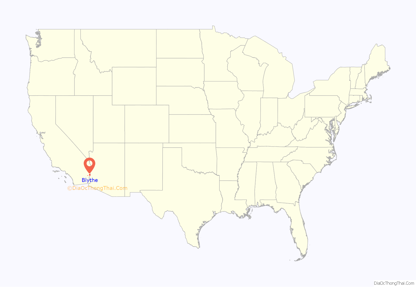
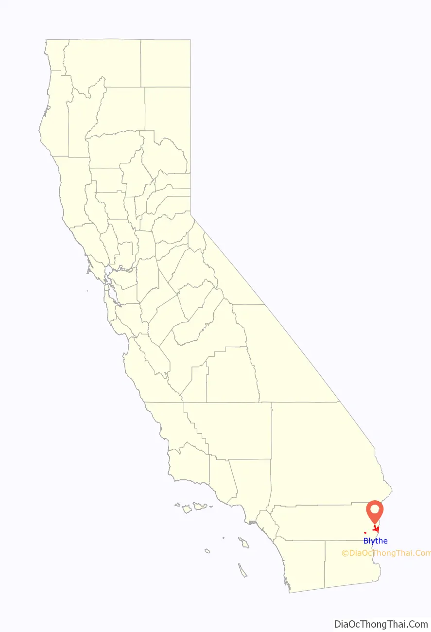
Blythe location map. Where is Blythe city?
History
Etymology
Blythe was named after Thomas Henry Blythe, a San Francisco businessman and entrepreneur. Mr. Blythe established primary water rights to the Colorado River in the southwestern California region in 1877. The town was originally named Blythe City, by Thomas Blythe himself, but the name was shortened to simply Blythe around the time the first post office was opened in 1908.
Early years
In the early or mid-1870s, William Calloway (known as Oliver Calloway in some sources), an engineer and a former captain of the 1st California Infantry Regiment, explored an area across the Colorado River from Ehrenberg, Arizona, and found its potential for development. Calloway made preliminary surveys and filed land claims under the Swamp Land Act of 1850. He interested the wealthy San Francisco Capitalist Thomas Henry Blythe (originally born Thomas Williams in Mold, Wales) to undertake development and settlement of an “empire” located next to the Colorado. Together they purchased a total of 140,000 acres under the Swamp Land Act, and another 35,000 acres under the Desert Land Act of 1877.
On July 17, 1877, Blythe filed his first claim for Colorado River water on what was to become the “Blythe Intake”. Blythe appointed another man named George Irish as manager to assist Calloway in building an irrigation system. Calloway died in a Chemehuevi attack on March 28, 1880, and was replaced by C.C. Miller, the father of Frank Augustus Miller. Thomas Blythe died on April 4, 1883; his only revisit to the valley was in November 1882. After his death, the work in the valley halted and Blythe’s estate subsequently went into litigation between his illegitimate daughter Florence and other claimants, the trial beginning in 1889. In the 1900s, Florence was awarded the estate, after several years of preceding rulings in favor of her and appeals against her.
20th century
Frank Murphy and Ed Williams, who were involved with the cattle industry in southeastern Arizona, came to the area in 1904 and were convinced it was well-suited for cattle and farming. With the Hobson brothers from Ventura County, they bought Blythe’s estate and formed the Palo Verde Land and Water Company. During 1911–1912, W.F. Holt, who helped develop nearby Imperial Valley, was the company’s general manager.
On August 8, 1916, the California Southern Railroad reached Blythe from the desert station of Rice, then known as Blythe Junction. It was later renamed to honor G.W. Rice, an engineer and superintendent of the railroad. The dramatic growth in the valley following this event attracted national attention. Production totals increased annually from virtually nothing to near $8,000,000 in few years, primarily from cotton and cotton seed shipped to the ports. The lower cotton prices in 1920 ended this prosperous time. The Atchison, Topeka and Santa Fe Railway began leasing the line in 1921 and acquired it at the end of 1942.
The first automobile bridge over the Colorado River between Blythe and Ehrenberg was constructed in 1928 to replace a cable ferry service. The bridge’s successor was built in the early 1960s and was expanded to four lanes and a pedestrian walkway in early 1974.
In 1935, the completion of Boulder Dam extinguished the annual destructive floods in the valley. As noted during the city’s fiftieth anniversary, some forty crops were grown on the farms, and large cattle feeds were another aspect of the agriculture industry. As of 1947, the Fisher ranch had the biggest herd of registered Brahman cattle in California, the breeding stock having been sold to western states and other countries.
During World War II, Blythe was the site of United States Army Air Forces facilities at the Blythe Airport and the Gary Field.
In 1972, Interstate 10 was built through the city, replacing US 60 and the previously decommissioned US 70 on Hobsonway as the main thoroughfare.
21st century
In 2016, the voter-approved recreational use of cannabis in California has made the cannabis industry drawn to the economically declined city due to lower land prices, water, and potentially lower taxes compared to other parts of the state.
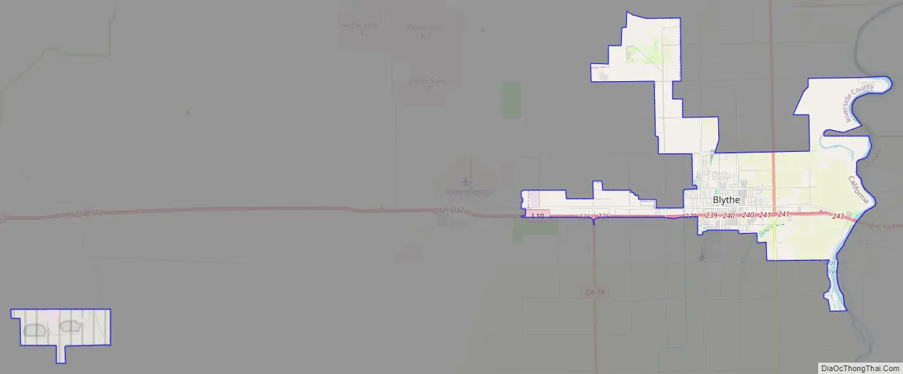
Blythe Road Map
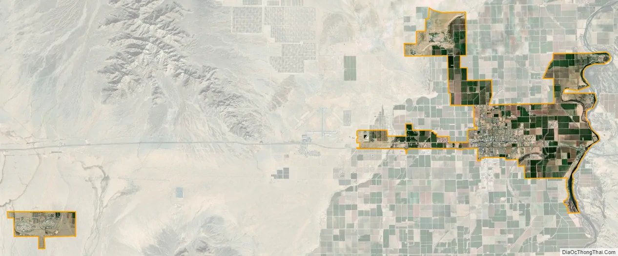
Blythe city Satellite Map
Geography
Blythe is located near the California/Arizona border in the Colorado Desert section of the Sonoran Desert, at the junction of Interstate 10 and US 95. According to the United States Census Bureau, the city has a total area of 27.0 square miles (70 km), of which 26.2 square miles (68 km) is land and 0.8 square miles (2.1 km) (2.9%) is water.
Nearby communities include Vidal to the north, Ripley to the south, Desert Center to the west, and Ehrenberg, Arizona, to the east. Major cities in the region include Yuma (85 miles), Indio (95 miles), Phoenix (150 miles), San Bernardino (170 miles), Riverside (172 miles), and Las Vegas (200 miles). Blythe is within 4 hours via car of 10% of the United States’ population.
Blythe has a hot desert climate, featuring extremely hot summers and mild winters. There are an average of 179.3 days with highs of 90 °F (32 °C) or higher. There are an average of 3.1 days with lows of 32 °F (0 °C) or lower. Until 2016, the record high temperature was 122 °F (50 °C) on July 7, 1920, and June 24, 1929. But on June 20, 2016, that long-standing record was shattered when Blythe reached 124 °F (51 °C). The record low temperature was 20 °F (−7 °C) on January 8, 1971. There are an average of 17.9 days with measurable precipitation. The wettest year was 1992 with 9.16 inches (23.3 cm) and the driest year was 1950 with 0.31 inches (0.79 cm). The most rainfall in one month was 5.92 inches (15.0 cm) in August 1951, which included the 24-hour record rainfall of 3.00 inches (7.6 cm) on August 26.
Also notable is the geological history of Blythe – despite California’s reputation for earthquakes, according to geologists Blythe has not had an earthquake centered in the city for over 500,000 years.
See also
Map of California State and its subdivision:- Alameda
- Alpine
- Amador
- Butte
- Calaveras
- Colusa
- Contra Costa
- Del Norte
- El Dorado
- Fresno
- Glenn
- Humboldt
- Imperial
- Inyo
- Kern
- Kings
- Lake
- Lassen
- Los Angeles
- Madera
- Marin
- Mariposa
- Mendocino
- Merced
- Modoc
- Mono
- Monterey
- Napa
- Nevada
- Orange
- Placer
- Plumas
- Riverside
- Sacramento
- San Benito
- San Bernardino
- San Diego
- San Francisco
- San Joaquin
- San Luis Obispo
- San Mateo
- Santa Barbara
- Santa Clara
- Santa Cruz
- Shasta
- Sierra
- Siskiyou
- Solano
- Sonoma
- Stanislaus
- Sutter
- Tehama
- Trinity
- Tulare
- Tuolumne
- Ventura
- Yolo
- Yuba
- Alabama
- Alaska
- Arizona
- Arkansas
- California
- Colorado
- Connecticut
- Delaware
- District of Columbia
- Florida
- Georgia
- Hawaii
- Idaho
- Illinois
- Indiana
- Iowa
- Kansas
- Kentucky
- Louisiana
- Maine
- Maryland
- Massachusetts
- Michigan
- Minnesota
- Mississippi
- Missouri
- Montana
- Nebraska
- Nevada
- New Hampshire
- New Jersey
- New Mexico
- New York
- North Carolina
- North Dakota
- Ohio
- Oklahoma
- Oregon
- Pennsylvania
- Rhode Island
- South Carolina
- South Dakota
- Tennessee
- Texas
- Utah
- Vermont
- Virginia
- Washington
- West Virginia
- Wisconsin
- Wyoming


