Murrieta /mjʊəriˈɛtə/ is a city in southwestern Riverside County, California, United States. The population of Murrieta was 110,949 as of the 2020 census. Murrieta experienced a 133.7% population increase between 2000 and 2010, making Murrieta one of the fastest-growing cities in the state during that period. Largely residential in character, Murrieta is typically characterized as a bedroom community. Murrieta is bordered by the city of Temecula to the south, the cities of Menifee and Wildomar to the north, and the unincorporated community of French Valley to the east. Murrieta is located in the center of the Los Angeles-San Diego mega-region. Murrieta is named for Juan Murrieta, a Californio ranchero who founded the town.
| Name: | Murrieta city |
|---|---|
| LSAD Code: | 25 |
| LSAD Description: | city (suffix) |
| State: | California |
| County: | Riverside County |
| Incorporated: | July 1, 1991 |
| Elevation: | 1,175 ft (334 m) |
| Total Area: | 33.65 sq mi (87.15 km²) |
| Land Area: | 33.61 sq mi (87.06 km²) |
| Water Area: | 0.04 sq mi (0.09 km²) 0.11% |
| Total Population: | 110,949 |
| Population Density: | 3,301.07/sq mi (1,274.55/km²) |
| ZIP code: | 92562–92564 |
| Area code: | 951 |
| FIPS code: | 0650076 |
| Website: | www.murrietaca.gov |
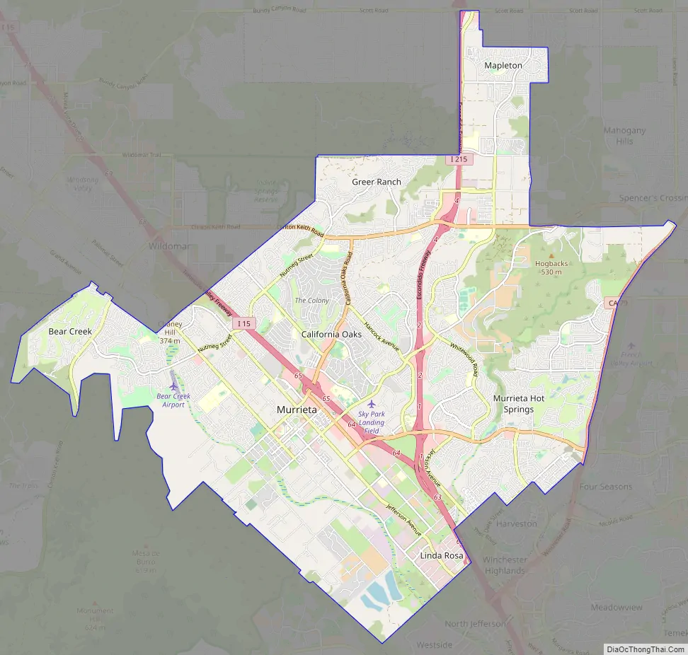
Online Interactive Map
Click on ![]() to view map in "full screen" mode.
to view map in "full screen" mode.
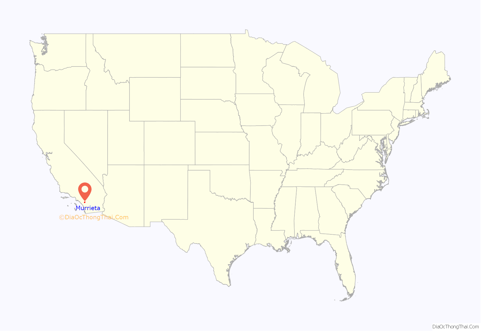
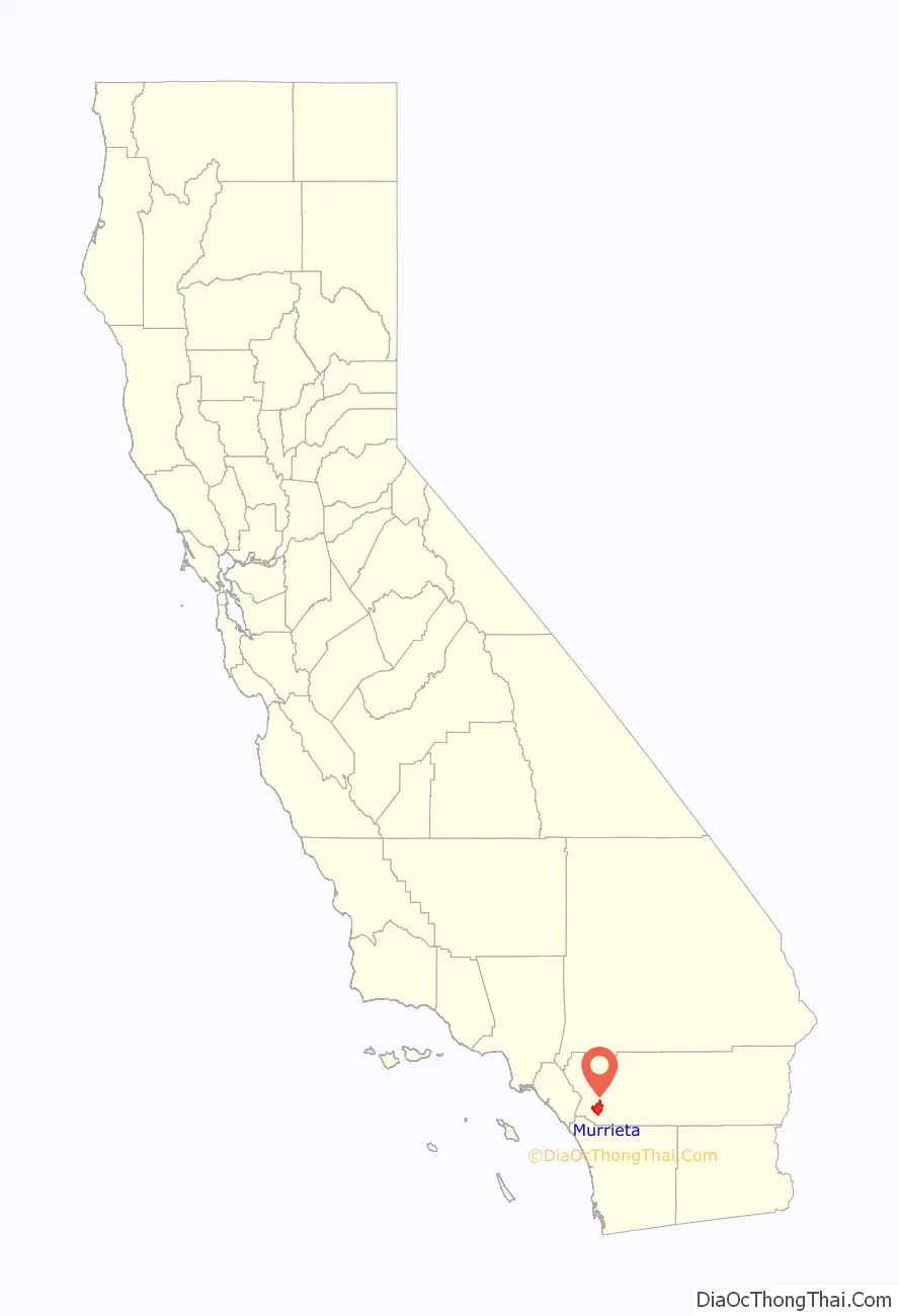
Murrieta location map. Where is Murrieta city?
History
For most of its history, Murrieta was not heavily populated. On June 9, 1873, Domingo Pujol, Francisco Sanjurjo, and Juan and Ezequiel Murrieta purchased the Rancho Pauba and Rancho Temecula Mexican land grants, comprising 52,000 acres (210 km) in the area. Ezequiel returned to Spain and turned the land over to his younger brother, Juan Murrieta (1844–1936), who brought 7,000 sheep to the valley in 1873, using the meadows to feed his sheep. The partnership dissolved in 1876 and Ezequiel and Juan Murrieta retained 15,000 acres of the northern half of the Temecula Rancho. Ezequiel and Juan Murrieta granted a right-of-way, one hundred feet wide to the California Southern Railroad through the Temecula Rancho on April 28, 1882 so that the railroad could be constructed through the valley.
In 1884, the Temecula Land and Water Company purchased about 14,500 acres from Juan Murrieta and mapped a townsite along the California Southern Railroad. Others discovered the valley after the construction of a depot in 1887 that connected Murrieta to the Southern California Railroad’s transcontinental route. By 1890, some 800 people lived in Murrieta. Today much of the site (about 50 acres) is home to a Bible college and conference center, owned by Calvary Chapel Costa Mesa, which has invested millions of dollars into restoring and rebuilding the old resort rooms. When the trains stopped in 1935, tourists—the lifeblood of the town—were much harder to come by. The boom that Murrieta had experienced due to the train and the hot springs gradually died, leaving Murrieta as a small country town.
Although US Route 395 had passed through Murrieta, it was not until Interstate 15 was built in the early 1980s that another boom began to take hold. By the late 1980s, suburban neighborhoods were being constructed, and people began moving to the Murrieta area from cities and towns in San Diego and Orange Counties, as well as other parts of Riverside County.
In 1990, residents began a campaign for city status which resulted in the incorporation of the City of Murrieta on July 1, 1991. By then the population was 24,000, a major increase from 2,200 in 1980. Between 1991 and 2007, the city’s population further increased to an estimated 97,257 residents, and at the 2010 United States Census the city’s population was 103,466, making it the largest city in southwestern Riverside County at that time.
In July 2014, Murrieta garnered national attention following days of citizen protests of detained immigrants. Murrieta residents successfully blocked busloads of illegal immigrant detainees. They were en route to a temporary relocation and detention facility, which the federal government had planned to establish in the town.
Murrieta Road Map
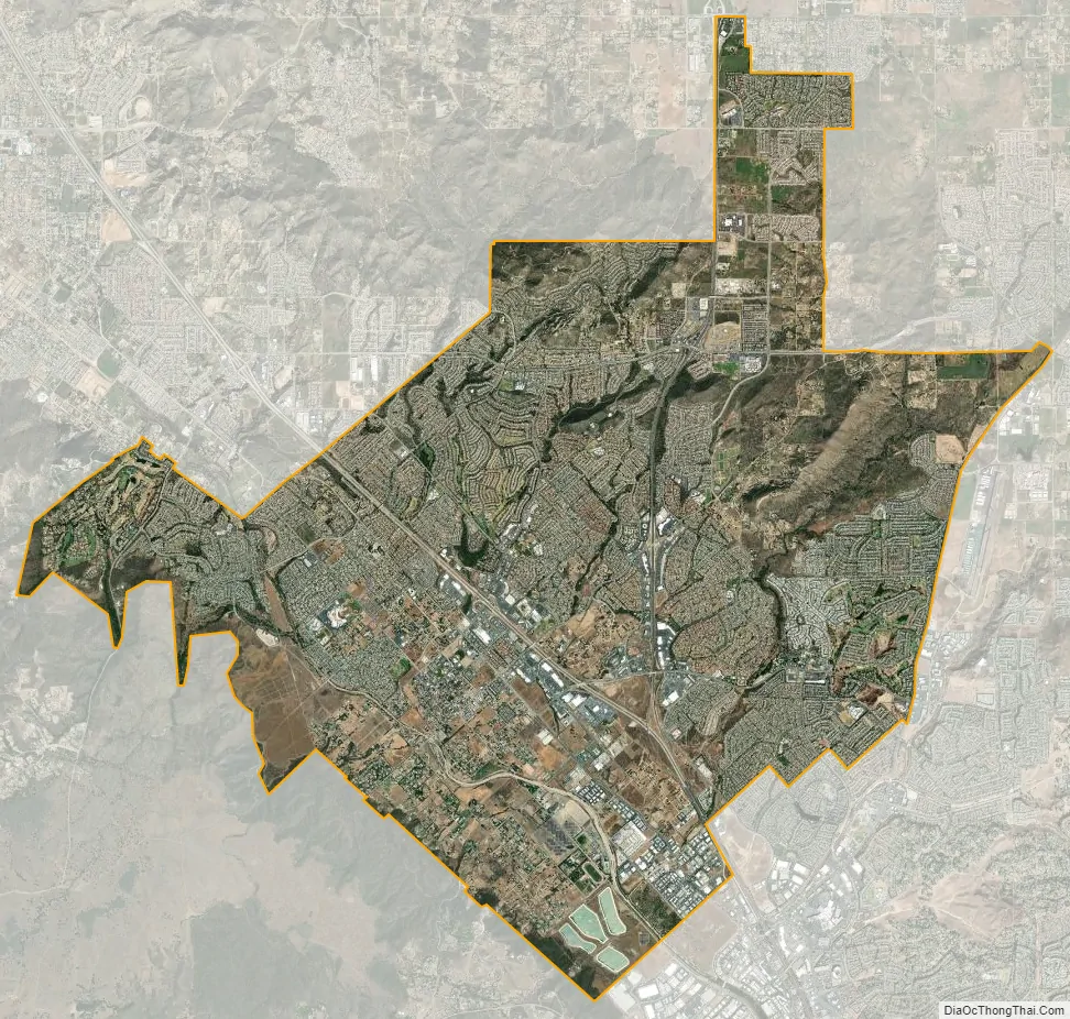
Murrieta city Satellite Map
Geography
According to the United States Census Bureau, the city has a total area of 33.6 sq mi (87.1 km), of which 99.89% of it is land and 0.11% is covered by water. Murrieta Creek runs southeasterly through the Murrieta Valley.
Climate
Murrieta has a Mediterranean climate or dry-summer subtropical (Köppen climate classification Csa). Murrieta has an average of 263 sunshine days and 35 days with measurable precipitation annually. April through November is warm to hot and dry with average high temperatures of 77–91 °F (25–33 °C) and lows of 44–60 °F (7–16 °C). The period of November through March is somewhat rainy. The city is also subject to the phenomenon typical of a microclimate: temperatures can vary as much as 18 °F (10 °C) between inland areas and the coast, with a temperature gradient over 1 °F per mile (0.3 °C/km) from the coast inland. Murrieta gets on average 31 days a year of some type of precipitation. Murrieta averages 15 inches (380 millimetres) of precipitation annually, which mainly occurs during the winter and spring (November through April) with generally light rain showers, but sometimes heavy rainfall and thunderstorms. Snowfall is rare in the city basin, but nearby mountains slopes typically receive snowfall each winter.
See also
Map of California State and its subdivision:- Alameda
- Alpine
- Amador
- Butte
- Calaveras
- Colusa
- Contra Costa
- Del Norte
- El Dorado
- Fresno
- Glenn
- Humboldt
- Imperial
- Inyo
- Kern
- Kings
- Lake
- Lassen
- Los Angeles
- Madera
- Marin
- Mariposa
- Mendocino
- Merced
- Modoc
- Mono
- Monterey
- Napa
- Nevada
- Orange
- Placer
- Plumas
- Riverside
- Sacramento
- San Benito
- San Bernardino
- San Diego
- San Francisco
- San Joaquin
- San Luis Obispo
- San Mateo
- Santa Barbara
- Santa Clara
- Santa Cruz
- Shasta
- Sierra
- Siskiyou
- Solano
- Sonoma
- Stanislaus
- Sutter
- Tehama
- Trinity
- Tulare
- Tuolumne
- Ventura
- Yolo
- Yuba
- Alabama
- Alaska
- Arizona
- Arkansas
- California
- Colorado
- Connecticut
- Delaware
- District of Columbia
- Florida
- Georgia
- Hawaii
- Idaho
- Illinois
- Indiana
- Iowa
- Kansas
- Kentucky
- Louisiana
- Maine
- Maryland
- Massachusetts
- Michigan
- Minnesota
- Mississippi
- Missouri
- Montana
- Nebraska
- Nevada
- New Hampshire
- New Jersey
- New Mexico
- New York
- North Carolina
- North Dakota
- Ohio
- Oklahoma
- Oregon
- Pennsylvania
- Rhode Island
- South Carolina
- South Dakota
- Tennessee
- Texas
- Utah
- Vermont
- Virginia
- Washington
- West Virginia
- Wisconsin
- Wyoming


