Rancho Cordova is a city in Sacramento County, California, United States which was incorporated in 2003. It is part of the Sacramento Metropolitan Area. The population was 64,776 at the 2010 census. In 2010 and 2019, Rancho Cordova was named as a winner of the All-America City Award.
| Name: | Rancho Cordova city |
|---|---|
| LSAD Code: | 25 |
| LSAD Description: | city (suffix) |
| State: | California |
| County: | Sacramento County |
| Incorporated: | July 1, 2003 |
| Elevation: | 89 ft (27 m) |
| Total Area: | 34.88 sq mi (90.33 km²) |
| Land Area: | 34.57 sq mi (89.53 km²) |
| Water Area: | 0.31 sq mi (0.80 km²) 1.08% |
| Total Population: | 64,776 |
| Population Density: | 2,172.09/sq mi (838.64/km²) |
| ZIP code: | 95670, 95741, 95742 |
| Area code: | 916, 279 |
| FIPS code: | 0659444 |
| GNISfeature ID: | 1659466 |
| Website: | www.cityofranchocordova.org |
Online Interactive Map
Click on ![]() to view map in "full screen" mode.
to view map in "full screen" mode.
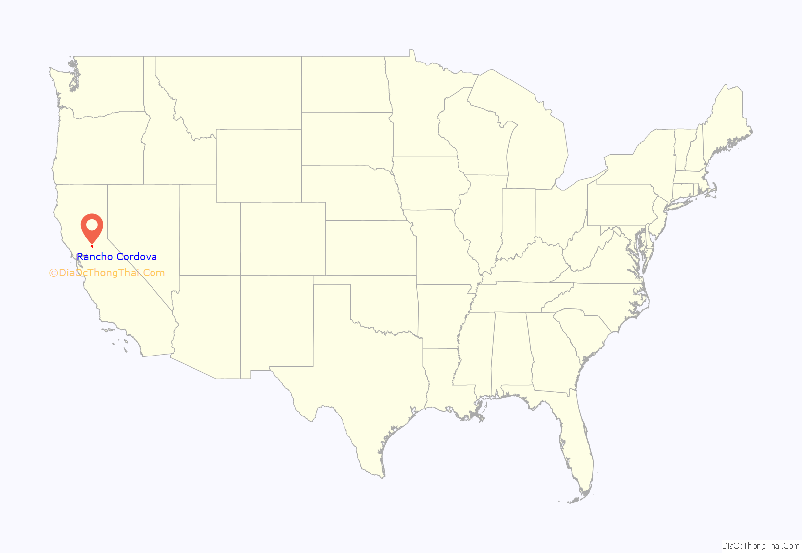
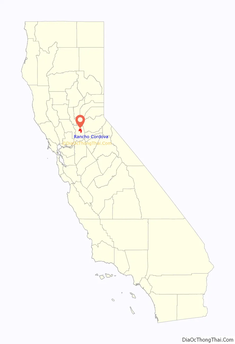
Rancho Cordova location map. Where is Rancho Cordova city?
History
Originally called Mayhew’s Crossing and Hangtown Crossing (c. 1855) during the Gold Rush era, the area was renamed Mayhew Station and Mills Station (c. 1900), respectively. The city itself was named for the Cordova Vineyard, which was located in the center of the Rancho Rio de los Americanos land grant. Other names of the town included Cordova Vineyards and Cordova Village, before it was officially named Rancho Cordova when a post office was established in the community in 1955.
In the Gold Rush era of mid-19th-century California, Placer mining took place around Rancho Cordova, and some traces of it can still be found. The elevation of the generally level terrain is approximately 118 feet (36 m) above mean sea level. Lone Star Gravel Company and other companies have historically extracted younger gravels at depths of 30 to 40 feet (12 m) without encountering groundwater, which is characteristically found at about 100 feet (30 m). Partially confined groundwater generally flows to the southwest.
For many years, Rancho Cordova was the community called ‘Mills’, located in the eastern part of the Brighton Township. It was called Mills as early as 1893, supposedly because of the old grist mills that were close by along the river. At the top of Bradshaw, along the American River, close to the oak tree that marked the northwest boundary of the Spanish Land Grant, Rancho Rio De Los Americanos, there are still some remains of foundations. They are close to the Grist Mill Dam Recreation Area along the American River Parkway. The southwestern boundary of the grant was 300 feet west of Bradshaw not far north of Florin Road. The boundary then went due east over to Grantline Road, and northeast along the roadway.
The 35,500 acre Rancho Rio De Los Americanos was granted to William Leidesdorff in 1844 but he died in 1848, leaving the Rancho and some properties in San Francisco to his heirs. Captain Joseph Folsom purchased the Rancho from the heirs and founded a town in 1855 which he named after himself – Folsom. The old Leidesdorff adobe was constructed in 1846 in the vicinity of Routier Station.
As the miners left Sacramento traveling to the foothills in search of gold, way stations grew up along the first dirt trails, and later more formal roads, that took travelers east. Commercial establishments, hotels, or ‘stations’ were developed at one-mile intervals along the route. Many of the stations ultimately also became the US Post Office for their area, and many of these early settlers served as postmaster or postmistress.
Travelers and miners apparently headed out L Street from Sacramento (the approximate alignment of present-day Folsom Blvd) along a plank, or macadam, road that ended at present day Bradshaw Road. Brighton, also called Five Mile Station, was the site of three inns. One inn, the Magnolia House, established in 1849, was the first stop on the Pony Express Route. The location is today marked by the old Brighton Station building, visible on the south side of Folsom Boulevard where the overpasses for Highway 50 and the light rail are located. One closer stop, at four miles, was known as Hoboken or Norristown, in the vicinity of CSUS. The old Perkins building, where the Jackson Highway leaves Folsom Boulevard, and Manlove were both locations for way stations.
The vicinity of Bradshaw was Ten Mile Station, the Patterson’s “American Fork House”, established in 1852, and the beginning of large farms, vineyards, and orchards. Up the road was Routier Station, established in 1871. Mrs. Mayhew left Mayhew Station to take over as PostMistress at Routier Station when the post office opened in 1887. Mr. Patterson was Postmaster there for a while also. Joseph Routier was widely renowned for many years for the quality of his produce. In 1866 the railroad built the train station between Folsom Boulevard and the tracks due to the size and dependability of the crop, and the need for a formal packing shed to house the produce waiting for the train. (The station still exists as Pfingst Realty Mr. Pfingst died in 2007; the structure is owned by his daughter.)
At eleven miles, the road forked. The Coloma Road went north along the river to Coloma and the northern mines, very close to its present location; the southerly fork headed for White Rock and the Southern Mines. The area was first known as Hangtown Crossing, referencing the route to Old Hangtown – or Placerville. The southerly fork was the White Rock Road, known at that time as the White Rock – Clarksville Immigrant Road. The outcropping of white rock marked the entry into El Dorado County, and Clarksville was the first sizable settlement over the hill. 15 Mile House was built in 1850, and is commemorated with a brick cairn on White Rock Road in front of the CalTrans Emergency Ops building. It was managed by A.M. Plummer until purchased in 1857 by its most famous innkeeper, H.F.W. Deterding. His son Charles ran the hotel until at least 1890, and their hospitality was known far and wide. 15 Mile House was the second official Pony Express remount station. Eleven miles east of that, the third remount station was located at Sportsman Hall at Mormon Island, before the express riders went over the mountains headed for St. Joseph, Missouri. The Mormon Island ruins surface from under Folsom Lake at Dike 8 during low water years.
There were also way stations along the Coloma Road, such as the 14 Mile House, built on the Coloma Road in 1850 by Mr. Rush, the original builder of Deterding’s 15 Mile House. In 1852 early settlement of the Mills area included a two-story inn owned by Louis Lepetit. Four stage lines came through there, and split, with two going southeast to Placerville, and two following the river to Coloma. In the 1880s a fire destroyed the inn, and Mr. Lepetit may have rebuilt across the road on the north side.
A strong community of vineyards and orchards had grown up between the 1850s and the 1880s. Maps of the area show the familiar names of Studarus, Williamson, Mendonca, Kelley, Carroll, Shields, Dauenhauer, Lauridson, Kilgore, and Deterding. The list goes on with names that to a small extent, have been preserved as place names. John Studarus was one of the early settlers. He had thirteen children. The presumed eldest, Charles, operated the family farms; John Jr., the second or third eldest, purchased five acres of land at Hangtown Crossing, near Lepetit’s site, and built a hotel. In 1911, he built the present day Mills Station. It was a general commercial building, housing a tavern and grocery store. The second floor was a large ballroom, where he celebrated the opening of the building by issuing an open invitation to everyone around to attend a grand ball. The building also housed the Post Office, and two of his children, William Henry and Helen, both ran the Post Office at various times.
William Henry Studarus died perhaps in the late 1970s, and Helen Studarus McCray, whom everyone remembers as the Post Mistress, died in 1982 or 1983. William Henry also helped his father run the store, selling groceries, hardware, and gasoline. At sometime prior to the war, the county established a branch of the free library, which local residents also remember coming to.
In 1949 Mills Station was bought by Mr. and Mrs. Lerch, parents of later Fire Chief Bob Lerch and famous baseball player Randy Lerch. Their daughter, Mrs. Doris Lauridson, held her wedding reception in the ballroom on the second floor in 1950. The general store, library, and gas station continued to serve the community. Mills Fire Department has been photographed several times with its fire trucks and firemen on parade out front. Gasoline was sold there (the pumps are visible in the 1952 photo). The building that previously sat across the street, housing the Sharp Shop, was a fire house, along with another small building on the east side of Routiers Road between Folsom Blvd. and Horn Road. The Sharp Shop, a lawn mower repair business, was finally demolished in about 2002. At that time it had deteriorated and the original walls had been replaced with corrugated metal panels, leaving virtually nothing of the original structure.
Tom Raley bought Mills Station in 1956. The Raley’s organization believes he ran the grocery store, but community residents do not remember it being called Raley’s. In 1972 after negotiations between the Fire District, Sacramento County, Raley’s, and the Sons and Daughters of the Golden West, the building was moved to back north of the Boulevard about 200 feet. It was renovated as a restaurant but was never quite successful, and changed hands many times over 20 years. The last tenant moved out in August 1991 and the building sat idle, used only by vagrants and transients. It was secured, preserved, and moved once again. In its final life, Mills Station has been restored as a community center at the Mather Field / Mills Light Rail Station approximately 1,000 feet from its original location. The agricultural heritage of Rancho Cordova fell onto hard times in the 1930s and 1940s. Along with Joseph Routier’s nationally recognized produce, wine from Roland Federspiel’s Cordova Vineyards had been served at White House table during the Teddy Roosevelt presidency. Unfortunately, northern California went through a lengthy period of drought. Making things worse, the State Legislature raised property tax rates, setting values at “the highest and best use” as opposed to the actual use of the land. It became more and more difficult for farmers to keep their land in production.
At this point, all of the young men returning from World War II were looking for places to settle down, find a job, buy a home, and raise their families. Roland Federspiel formed a partnership with Glenn Ahlstrom and a contractor named Jacobsen to build homes on land that had previously been vineyards. Up until that point after the War, there had not been any production housing in the United States. Homes had been constructed individually or in small numbers.
Construction began at the intersection of Folsom Boulevard and Zinfandel Drive. The first three homes on the west side of the street were the model homes. Duplexes on the opposite corners originally housed the sales office and post office, then the first office of The Grapevine newspaper.
Federspiel had chosen the name Cordova Vineyards with a nod to the Cordoba Region in Spain, and wanted to preserve the Cordova name. Glenn Ahlstrom drove down to San Francisco in his old woodie station wagon and physically brought back the first ‘post box’. The US Postal Service agreed to let them use the name Rancho Cordova as it was just the right size to fit around the circle of the old postal franking stamp. They named the streets for wine grapes. It is a treat to find some of those old grapes coming back into production again, with wines like Malbec and Barbera. In recognition of that heritage, Elliott Homes named all of the streets in the Villages of Zinfandel at Stonecreek for wineries around the world when they began to build at the south end of Zinfandel in 2000.
The community grew, and Folsom Boulevard began to fill in with commercial enterprise. Early structures included the Cordova Village Shopping Center and George E. Johnson’s Cordova Inn. (George E. Johnson is the father of restaurateur Eppie Johnson. The ‘E’ stands for Eppaminondous, and Eppie used it to name a more formal restaurant on Zinfandel around 1980. The building is still in operation as a restaurant today, but is on the fourth restaurant chain since then.)
Most of the residents of the 1950s and 1960s came to work at either Aerojet, during the height of the space race, or were stationed at Mather Air Force Base. There were only a little over 1,000 homes in the Mather housing area, so most people lived off base. Along with other people who found the new Rancho Cordova a desirable place to live were the many people who came to open businesses and establish all of the organizations that any true community needs in order to thrive and prosper. Early residents opened gas stations, insurance agencies, the Hallmark Store, Baskin Robbins Ice Cream, the veterinary office, medical offices, a travel agency, churches, and the florist shop. These community builders were also the principals at the junior and senior high schools, the manager at the Chamber of Commerce, the general manager at the Park District, the chief at the Fire District, pastors and priests. They founded local branches of Rotary, Kiwanis, Optimist Club, JCs, the Moose, and the Elks.
There were attempts to incorporate Rancho Cordova in 1961 and in 1978. The 1978 effort was kept alive over the next 20 years, finally getting on the ballot in November 2002. It passed with a record 77% of voters in support, a record that still stands today.
On February 16, 2000, Emery Worldwide Flight 17 crashed in Rancho Cordova. All three crew members, the only occupants of the aircraft, were killed.
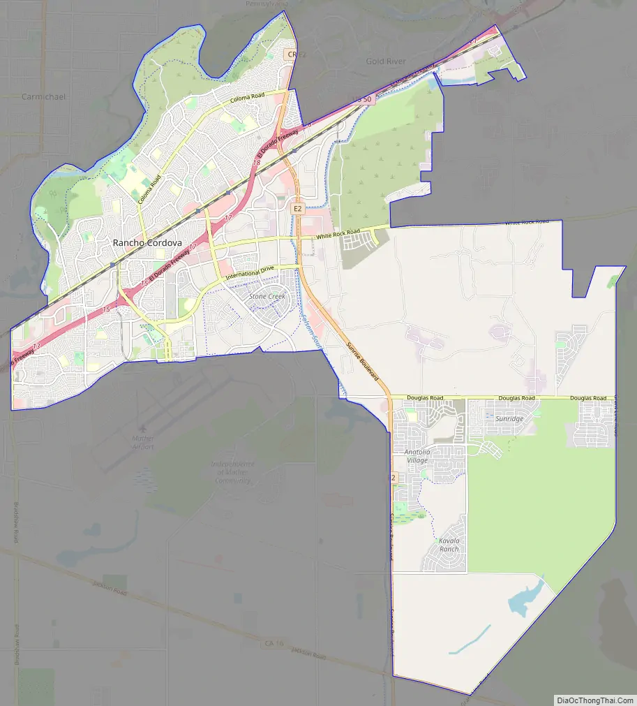
Rancho Cordova Road Map
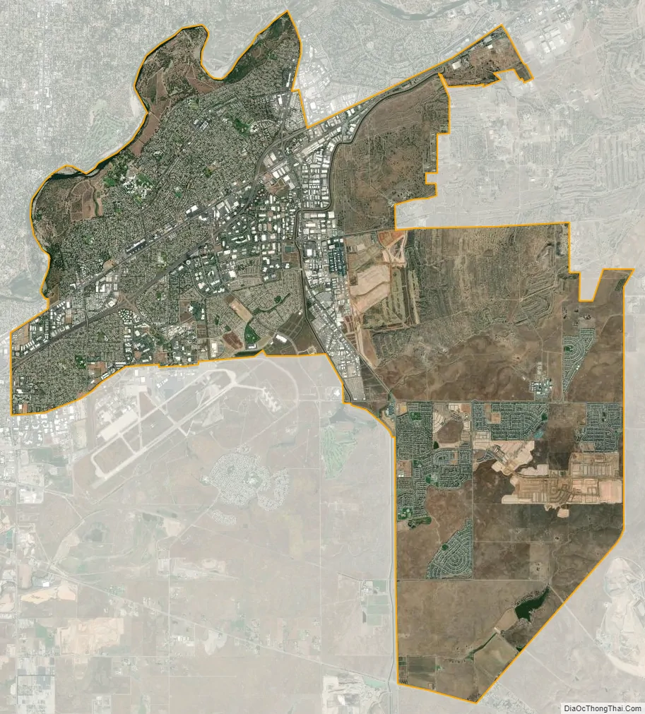
Rancho Cordova city Satellite Map
Geography
According to the United States Census Bureau, the CDP has a total area of 33.9 square miles (88 km), of which 33.5 square miles (87 km) of it is land and 0.4 square miles (1.0 km) of it (1.08%) is water. Rancho Cordova lies within the Sacramento Valley.
Climate
As part of the greater Sacramento area, Rancho Cordova experiences a Mediterranean climate (Koppen classification: Csa). Summers are hot and dry, while winters are cool and rainy. Monthly mean high temperatures range from 56.0 °F (13.3 °C) in January to 92.6 °F (33.7 °C) in July, while lows range from 39.2 °F (4.0 °C) in January to 59.2 °F (15.1 °C) in July. Yearly precipitation totals around 18.14 in (46.1 cm), with the majority of precipitation falling between December and March.
See also
Map of California State and its subdivision:- Alameda
- Alpine
- Amador
- Butte
- Calaveras
- Colusa
- Contra Costa
- Del Norte
- El Dorado
- Fresno
- Glenn
- Humboldt
- Imperial
- Inyo
- Kern
- Kings
- Lake
- Lassen
- Los Angeles
- Madera
- Marin
- Mariposa
- Mendocino
- Merced
- Modoc
- Mono
- Monterey
- Napa
- Nevada
- Orange
- Placer
- Plumas
- Riverside
- Sacramento
- San Benito
- San Bernardino
- San Diego
- San Francisco
- San Joaquin
- San Luis Obispo
- San Mateo
- Santa Barbara
- Santa Clara
- Santa Cruz
- Shasta
- Sierra
- Siskiyou
- Solano
- Sonoma
- Stanislaus
- Sutter
- Tehama
- Trinity
- Tulare
- Tuolumne
- Ventura
- Yolo
- Yuba
- Alabama
- Alaska
- Arizona
- Arkansas
- California
- Colorado
- Connecticut
- Delaware
- District of Columbia
- Florida
- Georgia
- Hawaii
- Idaho
- Illinois
- Indiana
- Iowa
- Kansas
- Kentucky
- Louisiana
- Maine
- Maryland
- Massachusetts
- Michigan
- Minnesota
- Mississippi
- Missouri
- Montana
- Nebraska
- Nevada
- New Hampshire
- New Jersey
- New Mexico
- New York
- North Carolina
- North Dakota
- Ohio
- Oklahoma
- Oregon
- Pennsylvania
- Rhode Island
- South Carolina
- South Dakota
- Tennessee
- Texas
- Utah
- Vermont
- Virginia
- Washington
- West Virginia
- Wisconsin
- Wyoming


