Tiburon (/ˈtɪbərɒn/; Spanish: Tiburón, [tiβuˈɾon]) is an incorporated town in Marin County, California. It is located on the Tiburon Peninsula, which reaches south into the San Francisco Bay. It shares a ZIP code with the smaller incorporated city of Belvedere (formerly a separate island), which occupies the southwest part of the peninsula and is contiguous with Tiburon. Tiburon is bordered by Corte Madera to the north and Mill Valley to the west, but is otherwise mostly surrounded by the bay. Besides Belvedere and Tiburon, much of the peninsula is unincorporated, including portions of the north side and the communities of Strawberry and Paradise Cay.
The population of Tiburon was 9,146 at the 2020 census and has 6,600 registered voters. Belvedere and Tiburon share a post office, library and recreation agency.
The city’s name derives from the Spanish word tiburón, which means “shark”. The name was first given to the peninsula on which the city is situated, and probably inspired by the prevalence of locally native leopard sharks in the surrounding waters. Tiburon was formerly the southern terminus of the San Francisco and North Pacific Railroad (subsequently the Northwestern Pacific Railroad), which transported freight for transfer to barges for shipping to cities around San Francisco Bay. It is now a commuter and tourist town, linked by fast ferry services to San Francisco and with a concentration of restaurants and clothes shops. It is the nearest mainland point to Angel Island and a regular ferry service connects to the island.
| Name: | Tiburon town |
|---|---|
| LSAD Code: | 43 |
| LSAD Description: | town (suffix) |
| State: | California |
| County: | Marin County |
| Incorporated: | June 23, 1964 |
| Elevation: | 13 ft (4 m) |
| Total Area: | 13.22 sq mi (34.23 km²) |
| Land Area: | 4.48 sq mi (11.60 km²) |
| Water Area: | 8.74 sq mi (22.63 km²) 66.27% |
| Total Population: | 9,146 |
| Population Density: | 2,027.6/sq mi (782.85/km²) |
| ZIP code: | 94920 |
| FIPS code: | 0678666 |
| Website: | townoftiburon.org |
Online Interactive Map
Click on ![]() to view map in "full screen" mode.
to view map in "full screen" mode.
Tiburon location map. Where is Tiburon town?


History
Earliest human habitation of the local area was by Native Americans, who have left rock carvings on Ring Mountain.
In 1884, the first post office in Tiburon opened. In 1964, Tiburon incorporated.
Tiburon has a Town Historian, David Gotz. Much of the modern history material below is drawn from the former Town Historian, Branwell Fanning’s “Brief History of Tiburon,” published in the Town of Tiburon’s General Plan.
1775–1882
Tiburón means “shark” in Spanish. Whether Lt. Juan Manuel de Ayala saw a number of sharks near where he anchored the San Carlos in August 1775, off what is now Angel Island, or whether the tree-covered Tiburon Peninsula looked like a shark we may never know. He named the land Punta del Tiburón, or Shark Point. The Coast Miwok Indians had lived here for thousands of years, but there is no clear concept of what they called the peninsula.
John Reed, from Dublin, received a provisional grant for much of Southern Marin, including the Tiburon Peninsula, from the Mexican authorities in 1831, and was formally granted the Rancho Corte Madera del Presidio in 1834. Reed married Hilaria Sánchez, daughter of the commandante of the San Francisco Presidio in 1836. The Reed name is preserved on streets, subdivisions, and the local school district. Various forms of Hilaria’s name, and that of her granddaughter Hilarita Reed, are found on streets, a housing development, and the Catholic Church.
Hilarita married Dr. Benjamin Lyford, who became the first land developer with his Lyford’s Hygeia, now Old Tiburon. The Benjamin and Hilarita Lyford House, formerly located on their dairy farm on Strawberry Point, is now a feature of the Audubon Society’s Western Headquarters and Sanctuary on Greenwood Beach Road.
Tiburon’s industrial era
Life changed little in the 40 years between the death of John Reed in 1842 and the arrival of Peter Donahue in 1882. Donahue brought with him the San Francisco and North Pacific Railroad (later the Northwestern Pacific Railroad). He made a deal with the Reed family for a right-of-way, blasted out the rock at Point Tiburon, and built a railroad terminal to connect with ferries of San Francisco Bay. The passenger ferries took commuters and automobiles to San Francisco and Sausalito, while barges carried loaded freight cars to San Francisco and Richmond.
Wildflowers surround Old St. Hilary’s, Tiburon’s iconic hillside landmark, which was originally a mission church named for St. Hilaire, Bishop of Poitiers. The heirs of John Reed — who held title to El Rancho Corte Madera del Presidio, the Mexican land grant that included the Tiburon Peninsula — deeded the one-quarter-acre site for $2.00 to the Archdiocese of San Francisco, which built the church as a place of worship for local railroad workers in 1888. The church was deconsecrated to make way for a new, larger one and was headed for destruction until several individuals intent on preserving local history established the Landmarks Society and purchased the site and building in 1959. It has served as a schoolroom and town meeting hall and is now a popular setting for weddings, concerts and other memorable events.
The last railroad-operated passenger ferry left Tiburon in 1941, but passenger and freight trains ran until 1967. Passenger ferry service was resumed in the 1960s when Harbor Carriers utilized sightseeing boats in the early morning and evening hours. In the 1970s, the railroad removed trackage, plugged tunnels, and demolished the trestle over Trestle Glen and railroad ferry pier. The railroad roadbed was purchased by the City of Tiburon and currently serves as the waterfront rail trail. After years of hearings and studies, the former railroad yards became the Point Tiburon housing and commercial project.
During its heyday, the railroad-ferry service brought many other industries to Tiburon. Codfish canneries sprouted along the bay shore to can fish shipped from Alaska. Ship dismantlers broke up obsolete ocean-going vessels. In 1904, the Navy established a huge coaling station on the east shore of the peninsula on the site of one of the old fish canneries. Brick kilns were built and several powder plants opened, and oyster beds developed in the shallow waters of the bay. The rail yards were fully equipped to repair and service trains, and build rolling stock and locomotives.
Several of the largest San Francisco Bay ferries were built in the Tiburon yards. The Navy coaling station has played a prominent part in the history of both Tiburon and Bay Area at large. Theodore Roosevelt’s Great White Fleet was refueled there on its famous round-the-world cruise. Coaling service ended in 1931 and the California Maritime Academy moved in to train officers for the merchant fleet. Because the cranes remaining from coaling operations were operational, the company spinning cables for the Golden Gate Bridge set up shop.
World War II
As World War II loomed, the coaling station site was transformed into the United States Navy Net Depot Tiburon. This facility was used to manufacture and service nets used to stop enemy torpedoes and submarines from entering San Francisco Bay. Later, the U.S. Bureau of Mines and the U.S. Bureau of Fisheries established research facilities on the site, and the Coast Guard’s icebreakers made this their summer home. It is now the Romberg Tiburon Center for Environmental Studies operated by San Francisco State University.
With all the seamen, sailors, railroad workers, cannery employees, and local dairymen in Tiburon, the taverns and other attractions of Main Street were popular on Saturday night. Prohibition did not interrupt Main Street activities as the railroad workers were able to signal the Tiburon depot as soon as revenuers boarded a train or ferry headed for town. By the time they got to Tiburon, prayer meetings were being held in the taverns. The volunteer fire department organized spirited baseball games, and the Corinthian Yacht Club was in full swing, so Main Street was not the only activity center.
World War II brought more people to Tiburon as the Navy built housing for NetDepot workers on the site of the present Hilarita Housing, for sailors from submarines at an annex to the Net Depot (now Paradise Beach County Park). Real estate development was minimal until after the war. The descendants of the Reed family still controlled most of the land that was used for cattle ranching. Small areas of filled land were sold to create the Bel Aire and Belveron Gardens subdivisions. The Little Reed Ranch was sold and Hawthorne Terrace, Del Mar, and Reed Heights subdivisions were under way by the time the County finally began preparing a Master Plan for the Tiburon Peninsula.
After several years of public hearings and discussions with the primary landowners, a Master Plan was completed in 1956. It included freeways on both sides of the peninsula, a four lane “ridge route” down the center of the peninsula (with a high-level bridge over Trestle Glen Boulevard), a shopping center on the crest of Ring Mountain, and a bridge to San Francisco (via Angel Island and Alcatraz) off the end. A land-use density of two homes to the acre, plus areas zoned for apartments and duplexes, would have permitted 50,000 to 60,000 people to live in Tiburon.
City incorporation and growth
There had been numerous attempts to incorporate a City of Tiburon over the years, but they had all failed to come to a vote due to the opposition of the large land owners. The only semblance of local land use input came from the Tiburon Peninsula Coordinating Council (TPCC). This was made up of representatives of each of the home owners associations; the school, fire and sanitary districts; and the City of Belvedere. In 1963, after a number of adverse rulings by County planners regarding development on the Tiburon Peninsula, the leaders of the TPCC decided that another attempt to incorporate was justified. A separate incorporation committee was established and work began. The main issues were: revision of the 1956 Master Plan, improved police services, opposition to the bridge to San Francisco, preservation of open space, and a desire for responsive local government.
One of the first challenges to be decided was just what properties were to be included in the incorporated area. The mapping committee started with the Tiburon Fire Protection District map as a base. The properties of large land owners who had been able to frustrate previous attempts were eliminated from the map. Certain areas, such as the Reedlands and part of Belveron Gardens, which were outside the Tiburon Fire District, but which wanted to be in the new city, were added. Angel Island, also outside the fire district boundary, was more controversial. Most did not see any value to having it within the city limits, as it was a state park. The counter argument was that it was “there”, and we wanted a say in whatever future development might be planned. The County Boundary Commission (later Marin Local Agency Formation Commission, or LAFCO), at the time made up of the members of the board of supervisors, wanted it out of the new city because of potential sales tax revenues.
They finally yielded to arguments put forth by the incorporation committee, and let it remain within the new city limits. In March 1964 an election was held to create the Town of Tiburon, and on June 23, 1964, the incorporation was final and a town council seated, and mayor elected.
A city manager was hired and a contract for police services was made with the county sheriff. A Planning Commission was established and commissioners appointed. Offices at 80 Main Street were rented. To help plan for the future the Tiburon Advisory Committee was appointed, consisting of citizens who had been active in community affairs. Their report, issued in 1965, outlined goals in land use, recreation, traffic, and “image”.
In 1966, at the first election after incorporation, three of the incumbents were replaced. Over the next several years, the new city council strengthened the planning commission and divided it further into boards of design review and adjustments. They completed a new master plan and general plan for the peninsula and new zoning ordinances to implement the plans. They also created a parks and recreation commission. Special ordinances to protect trees and to protect views were created. Property values were rising faster than funds could be accumulated, so bonds were issued and several hundred acres of open space were acquired. Several hundred additional acres were purchased by the Nature Conservancy to permanently protect the ridgelines, and the city purchased additional land from the Navy. The railroad right-of-way, almost 2.5 miles (4.0 km) of frontage on Richardson Bay, was acquired for a rail trail.
One of the most difficult decisions involved traffic planning. After numerous public hearings it was finally decided that Tiburon Boulevard would remain a two-lane road east of Trestle Glen Boulevard traffic lights and turnouts were scheduled east of that point and eventually built. The four-lane bypass section from Highway 101 to Blackie’s Pasture (the old Tiburon Boulevard became Greenwood Beach Road) was completed in 1966. The California Department of Transportation (Caltrans) had anticipated extending the four lanes downtown, so the fill created during this project was placed in the Bay east of Blackie’s Pasture, and after the City did some land swapping with Caltrans, became McKegney Green and the park South of the Knoll Park. Blackie’s Pasture property was also acquired and became part of the series of waterfront parks and paths known as the Richardson Bay Lineal Park.
LAFCO determined that Tiburon’s sphere of influence would extend to Highway 101. Annexation of the rest of the peninsula was attempted but never successful due to opposition in Strawberry. Eventually, those areas that wished to be within the city limits were annexed, and the city grew westward to include the Reedland Woods, Bel Aire, Tiburon Crest and Cypress Hollow subdivisions.
After 1997
The completion of the Point Tiburon development in the former railroad yards in 1985 signaled a change in the population mix and needs of the area. In 1997 a new Town Hall was opened with a new Belvedere-Tiburon Library next door. A new police station followed in 2000.
Following a large and successful Millennium Party, the Town has pursued a policy to revitalize Main Street and the rest of downtown Tiburon. Main Street was reconstructed to make it and the shops and restaurants handicapped accessible without ruining its quaint charm. The Allan Thompson Walkway along the water side of Main Street was completely rebuilt. In the summer of 2004, a series of “Friday Nights on Main Street” community parties was inaugurated. Main Street was closed to automobile traffic on Friday nights during the summer and the restaurants created special menus for the occasion. Tables in the street in front of each restaurant added to the festivities. As of 2017, the festival continues.
In November 2006, a commissioned fountain with a nautically themed sculpture titled “Coming About” at the entrance to Main Street was formally dedicated. The $250,000 material cost of the sculpture was donated by the Zelinsky family, longtime owners of many commercial properties in Tiburon. The sculpture was designed by Jeffery Reed and Jennifer Madden, who donated 6000 hours to its creation.
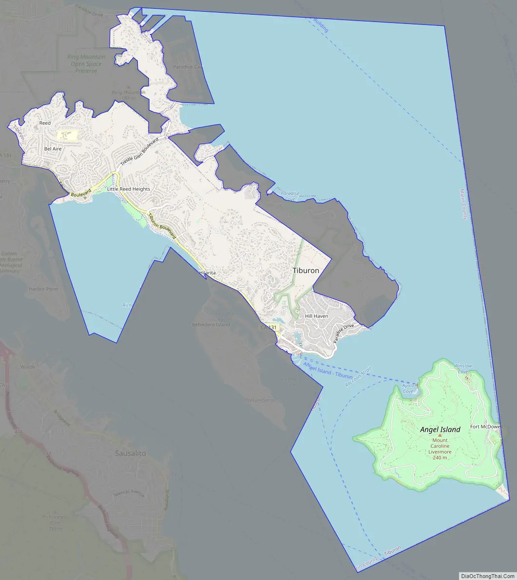
Tiburon Road Map
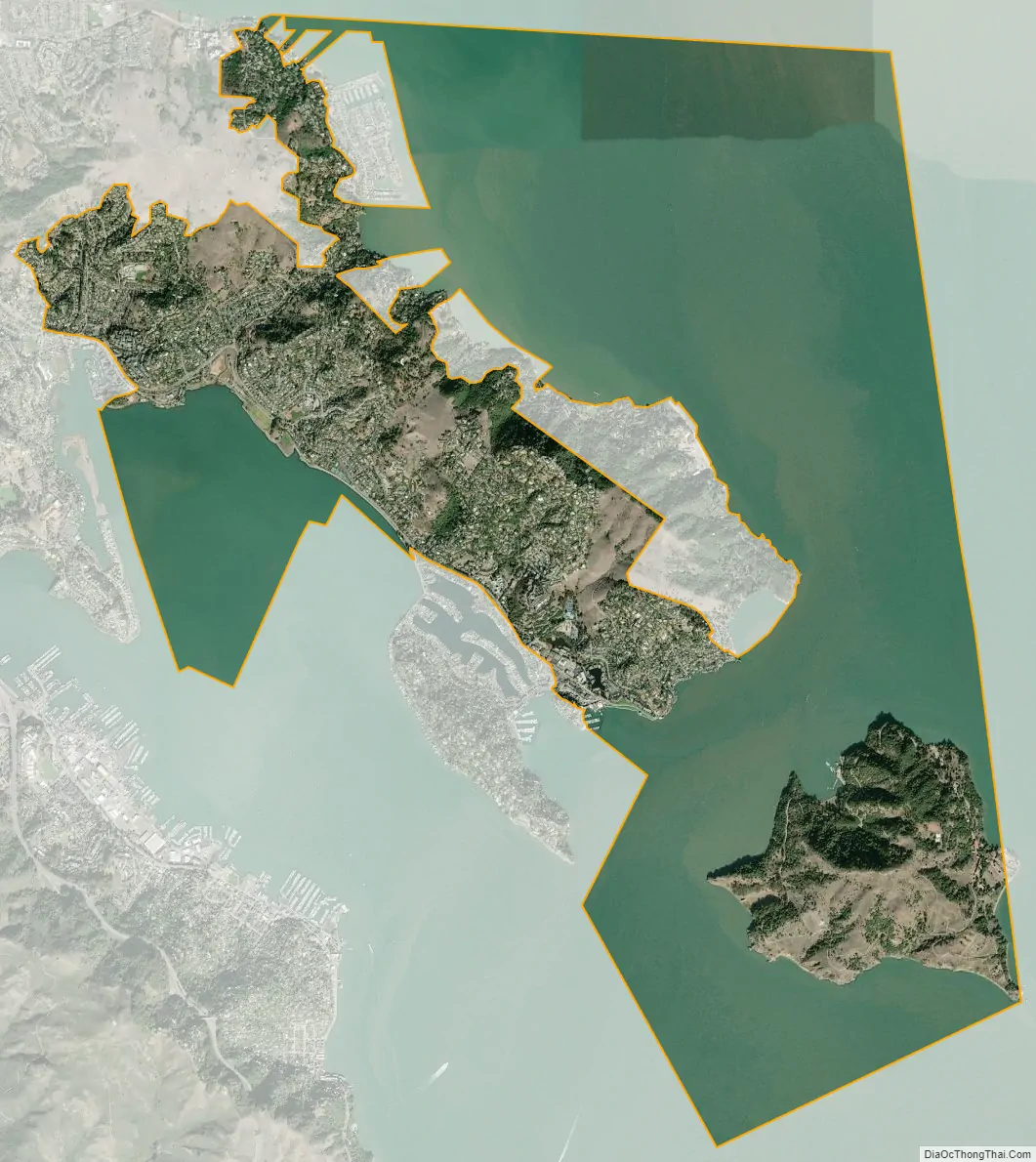
Tiburon city Satellite Map
Geography
Tiburon is located at 37°52′25″N 122°27′24″W / 37.87361°N 122.45667°W / 37.87361; -122.45667.
According to the United States Census Bureau, the town has a total area of 13.2 square miles (34 km). 4.4 square miles (11 km) of it is land and 8.7 square miles (23 km) of it (66.27%) is water, much in the form of Richardson Bay.
The serpentine soils of Ring Mountain and the Tiburon hills are host to a unique plant community, including several endemic or near-endemic species, notably, the Tiburon mariposa lily, the Tiburon indian paintbrush, and the Tiburon jewelflower, as well as a number of other rare and endangered species Ring Mountain is also a significant location of Native American prehistoric sites, notably rock carvings.
See also
Map of California State and its subdivision:- Alameda
- Alpine
- Amador
- Butte
- Calaveras
- Colusa
- Contra Costa
- Del Norte
- El Dorado
- Fresno
- Glenn
- Humboldt
- Imperial
- Inyo
- Kern
- Kings
- Lake
- Lassen
- Los Angeles
- Madera
- Marin
- Mariposa
- Mendocino
- Merced
- Modoc
- Mono
- Monterey
- Napa
- Nevada
- Orange
- Placer
- Plumas
- Riverside
- Sacramento
- San Benito
- San Bernardino
- San Diego
- San Francisco
- San Joaquin
- San Luis Obispo
- San Mateo
- Santa Barbara
- Santa Clara
- Santa Cruz
- Shasta
- Sierra
- Siskiyou
- Solano
- Sonoma
- Stanislaus
- Sutter
- Tehama
- Trinity
- Tulare
- Tuolumne
- Ventura
- Yolo
- Yuba
- Alabama
- Alaska
- Arizona
- Arkansas
- California
- Colorado
- Connecticut
- Delaware
- District of Columbia
- Florida
- Georgia
- Hawaii
- Idaho
- Illinois
- Indiana
- Iowa
- Kansas
- Kentucky
- Louisiana
- Maine
- Maryland
- Massachusetts
- Michigan
- Minnesota
- Mississippi
- Missouri
- Montana
- Nebraska
- Nevada
- New Hampshire
- New Jersey
- New Mexico
- New York
- North Carolina
- North Dakota
- Ohio
- Oklahoma
- Oregon
- Pennsylvania
- Rhode Island
- South Carolina
- South Dakota
- Tennessee
- Texas
- Utah
- Vermont
- Virginia
- Washington
- West Virginia
- Wisconsin
- Wyoming


