Fulton is a city in the western part of Oswego County, New York, United States. The population was 11,896 as of the 2010 census. The city is named after Robert Fulton, the inventor of the steamboat.
| Name: | Fulton city |
|---|---|
| LSAD Code: | 25 |
| LSAD Description: | city (suffix) |
| State: | New York |
| County: | Oswego County |
| Total Area: | 4.96 sq mi (12.86 km²) |
| Land Area: | 3.92 sq mi (10.16 km²) |
| Water Area: | 1.04 sq mi (2.69 km²) |
| Total Population: | 11,389 |
| Population Density: | 2,903.14/sq mi (1,120.85/km²) |
| FIPS code: | 3627815 |
| Website: | http://cityoffulton.com |
Online Interactive Map
Click on ![]() to view map in "full screen" mode.
to view map in "full screen" mode.
Fulton location map. Where is Fulton city?
History
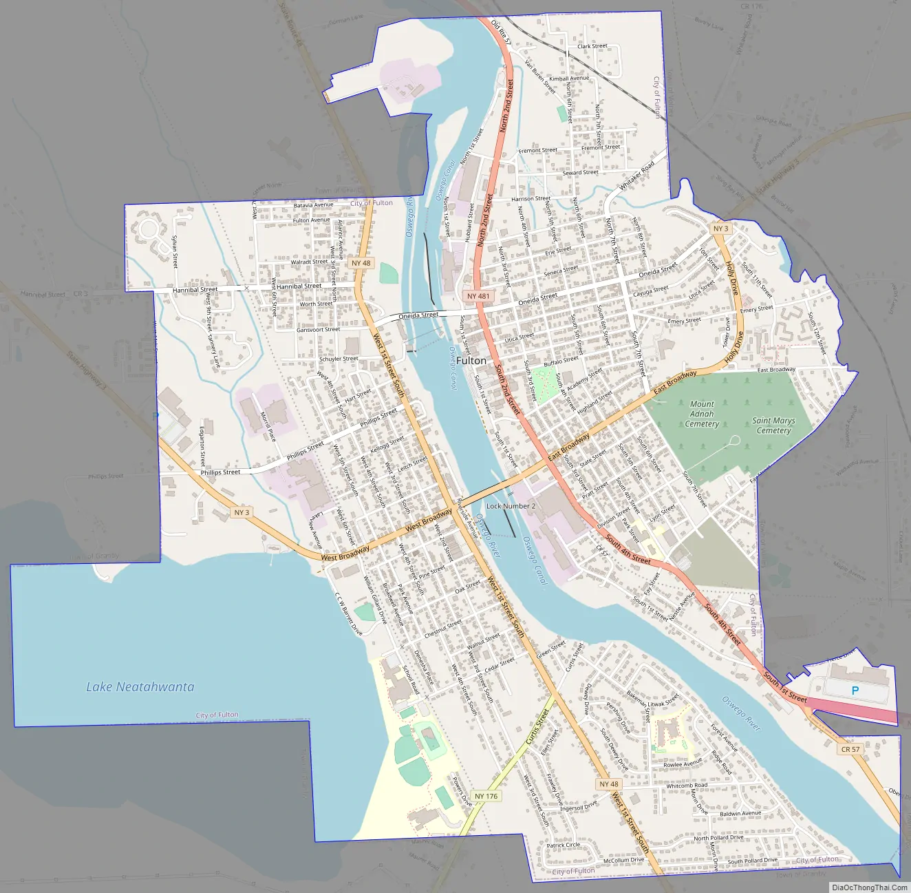
The city of Fulton is a community in two parts. The area on the west side of the Oswego River was formerly known as “Oswego Falls” recognizing the nearby rapids on the river. (The name “Oswego” is from the Iroquois word meaning “the outpouring.”) It was one of the first regions settled in the original Town of Granby. Settlements took place in two west-side locations, the “Upper Landing” and the “Lower Landing.” The community was incorporated as a village in 1835. In 1902, the Village of Fulton and the Village of Oswego Falls merged, and the resulting community was chartered as the City of Fulton. The two sides of the river have long been connected by two bridges-one known locally as the “upper bridge” (Broadway/NY State Route 3) and the other more commonly known as the “lower bridge” (Oneida St.) Both bridges have been rebuilt or refurbished a number of times during the history of the villages and city.
On August 6, 1931, Baseball Hall of Fame pitcher Grover Cleveland Alexander, pitching for the House of David semi-pro team, defeated the Byrne Sieberlings 5–3 in a game played in Fulton, NY. The contest was played before only 2,000 people. The Byrne Sieberlings, sponsored by the J. P. Byrne Tire Company, featured some of Central New York’s greatest semi-pro ball players.
The industrial nature of the small city led to a very stable workforce for many years. In fact, during the Great Depression of the early 1930s, the New York Sun newspaper (NYC) wrote a lengthy article describing Fulton, its residents and the strong local economy. It was headlined as, “Fulton, the City the Great Depression Missed.”
In 1942, Caroline Speare Rohland won a WPA commission to paint a post office mural for the town. Father LeMoyne Trying to Convert the Indians on Pathfinder Island was an oil on canvas depicting local Indians interacting with Europeans. The post office was placed on the National Register of Historic Places for Oswego County, New York in 1989.
At a May 2009 Common Council meeting, it was disclosed that the City of Fulton was exploring the possibility of merging with the neighboring towns of Granby and Volney to create one larger city. This idea has been floated several times before and has yet to come to fruition.
The Oak Street School, Mount Adnah Cemetery, Fulton Public Library, Chancellor (tugboat), John Wells Pratt House, State Street Methodist Episcopal Church, David Van Buren House, John Van Buren Tavern, Volkert Van Buren House, and United States Post Office are listed on the National Register of Historic Places. The Oswego Canal, which passes through Fulton, is included in the New York State Barge Canal Historic District. The West Broadway Commercial Historic District was added to the National Register of Historic Places in 2020.
Fulton Road Map
Fulton city Satellite Map
Geography
According to the United States Census Bureau, the city has a total area of 4.8 square miles (12 km), of which 3.8 square miles (9.8 km) is land and 0.9 square miles (2.3 km) (19.75%) is water.
Fulton is located near Lake Ontario and receives significant “lake-effect snow” fall in excess of a 100 inches (250 cm) per year.
See also
Map of New York State and its subdivision:- Albany
- Allegany
- Bronx
- Broome
- Cattaraugus
- Cayuga
- Chautauqua
- Chemung
- Chenango
- Clinton
- Columbia
- Cortland
- Delaware
- Dutchess
- Erie
- Essex
- Franklin
- Fulton
- Genesee
- Greene
- Hamilton
- Herkimer
- Jefferson
- Kings
- Lake Ontario
- Lewis
- Livingston
- Madison
- Monroe
- Montgomery
- Nassau
- New York
- Niagara
- Oneida
- Onondaga
- Ontario
- Orange
- Orleans
- Oswego
- Otsego
- Putnam
- Queens
- Rensselaer
- Richmond
- Rockland
- Saint Lawrence
- Saratoga
- Schenectady
- Schoharie
- Schuyler
- Seneca
- Steuben
- Suffolk
- Sullivan
- Tioga
- Tompkins
- Ulster
- Warren
- Washington
- Wayne
- Westchester
- Wyoming
- Yates
- Alabama
- Alaska
- Arizona
- Arkansas
- California
- Colorado
- Connecticut
- Delaware
- District of Columbia
- Florida
- Georgia
- Hawaii
- Idaho
- Illinois
- Indiana
- Iowa
- Kansas
- Kentucky
- Louisiana
- Maine
- Maryland
- Massachusetts
- Michigan
- Minnesota
- Mississippi
- Missouri
- Montana
- Nebraska
- Nevada
- New Hampshire
- New Jersey
- New Mexico
- New York
- North Carolina
- North Dakota
- Ohio
- Oklahoma
- Oregon
- Pennsylvania
- Rhode Island
- South Carolina
- South Dakota
- Tennessee
- Texas
- Utah
- Vermont
- Virginia
- Washington
- West Virginia
- Wisconsin
- Wyoming


