Mastic Beach is a hamlet and census-designated place, and former village in the southeastern part of the Town of Brookhaven in Suffolk County, on Long Island, in New York, United States. The population was 14,849 at the 2010 census, when it was an unincorporated census-designated place for the first time.
| Name: | Mastic Beach CDP |
|---|---|
| LSAD Code: | 57 |
| LSAD Description: | CDP (suffix) |
| State: | New York |
| County: | Suffolk County |
| Incorporated: | August 31, 2010 |
| Elevation: | 7 ft (2 m) |
| Total Area: | 6.00 sq mi (15.55 km²) |
| Land Area: | 4.90 sq mi (12.69 km²) |
| Water Area: | 1.10 sq mi (2.86 km²) |
| Total Population: | 14,199 |
| Population Density: | 2,898.94/sq mi (1,119.19/km²) |
| ZIP code: | 11951 |
| Area code: | 631, 934 |
| FIPS code: | 3646085 |
| GNISfeature ID: | 0970340 |
Online Interactive Map
Click on ![]() to view map in "full screen" mode.
to view map in "full screen" mode.
Mastic Beach location map. Where is Mastic Beach CDP?


History
In 2010, a group of residents sought to incorporate Mastic Beach as a village. Petitioners blamed the town of Brookhaven for not doing enough code enforcement on blighted streets and eyesore buildings, believing more diligent code enforcement under village control would improve the community aesthetics. Opponents were concerned that creating the village would increase taxes, and that estimates for the proposed village’s total budget were low. At $549,500 annually, the village would take up building code enforcement, leaving police, fire, and sanitation to Brookhaven.
After a vote on August 31, 2010, incorporation was approved. The proposed incorporation needed to be passed by a majority in order for the hamlet to become a village. The first elected mayor was Paul Breschard.
The boundaries of the village of Mastic Beach differed from those of the previous census-designated place (CDP). The village did not include the William Floyd House grounds as well as a few blocks in the extreme southwest of the CDP, but it added several blocks west of Mastic Road and Commack Road.
Dissolution
Residents voted 1,922 to 1,215 on November 8, 2016, to revert to an unincorporated area with services handled by the Town of Brookhaven. The decision to dissolve the village was decided upon due to political issues and fiscal concerns.
A formal dissolution plan was developed over several months and approved by the Village Board (4–1) at a special meeting on March 16, 2017. The dissolution took place on January 1, 2018.
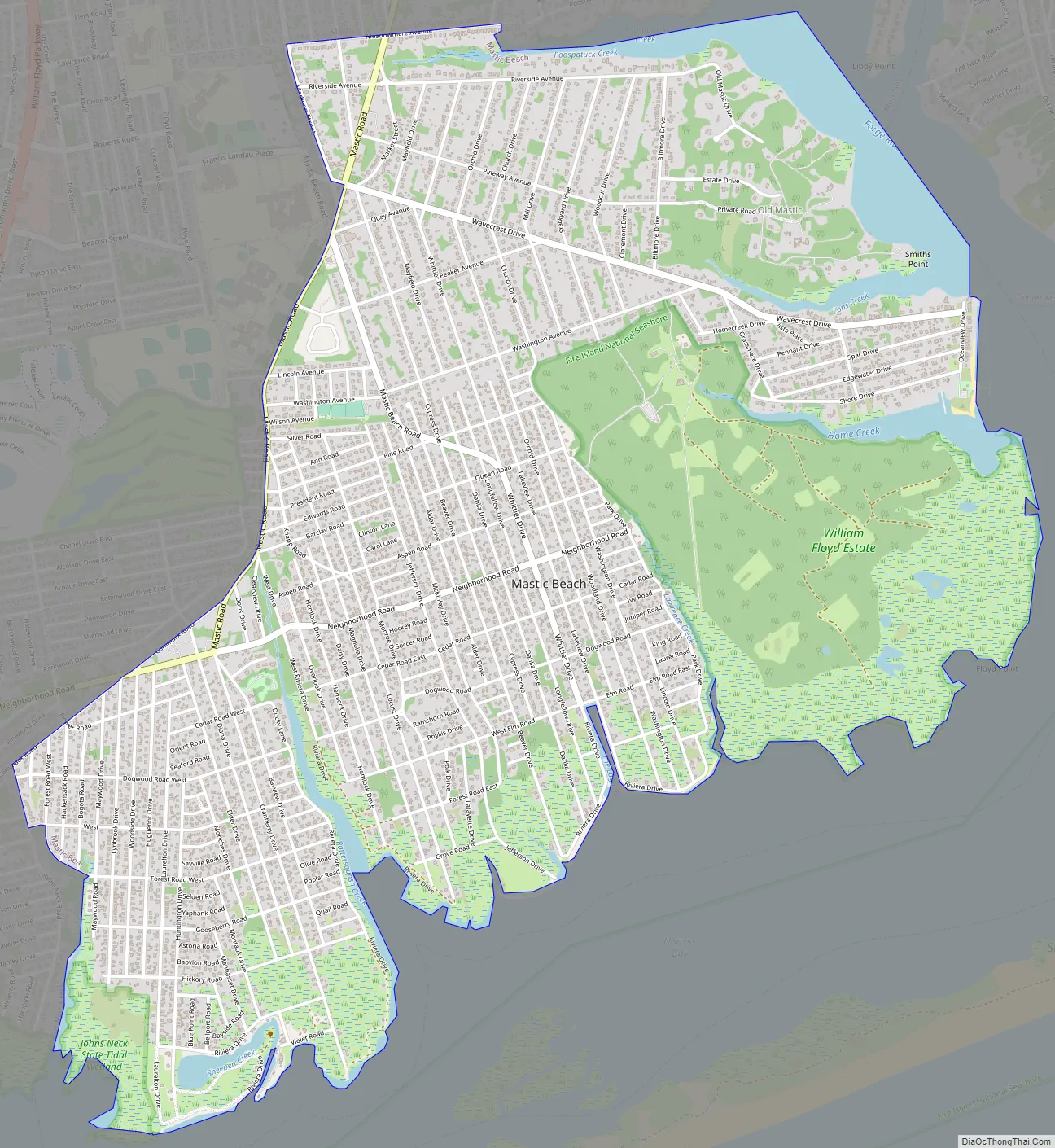
Mastic Beach Road Map
Mastic Beach city Satellite Map

Geography
According to the United States Census Bureau, the CDP had a total area of 5.3 square miles (14 km), of which 4.2 square miles (11 km) was land and 1.1 square miles (2.8 km), or 20.34%, was water.
Mastic Beach is located on the South Shore of Long Island roughly 70 miles (110 km) from New York City, and is accessible via the Long Island Rail Road’s Montauk Branch. Nearby are Smith Point County Park and the Fire Island National Seashore. It is on a peninsula extending into Moriches Bay.
Mastic Beach is located in the Forge River–Moriches Bay Watershed, and is located within the larger Long Island Sound/Atlantic Ocean Watershed.
See also
Map of New York State and its subdivision:- Albany
- Allegany
- Bronx
- Broome
- Cattaraugus
- Cayuga
- Chautauqua
- Chemung
- Chenango
- Clinton
- Columbia
- Cortland
- Delaware
- Dutchess
- Erie
- Essex
- Franklin
- Fulton
- Genesee
- Greene
- Hamilton
- Herkimer
- Jefferson
- Kings
- Lake Ontario
- Lewis
- Livingston
- Madison
- Monroe
- Montgomery
- Nassau
- New York
- Niagara
- Oneida
- Onondaga
- Ontario
- Orange
- Orleans
- Oswego
- Otsego
- Putnam
- Queens
- Rensselaer
- Richmond
- Rockland
- Saint Lawrence
- Saratoga
- Schenectady
- Schoharie
- Schuyler
- Seneca
- Steuben
- Suffolk
- Sullivan
- Tioga
- Tompkins
- Ulster
- Warren
- Washington
- Wayne
- Westchester
- Wyoming
- Yates
- Alabama
- Alaska
- Arizona
- Arkansas
- California
- Colorado
- Connecticut
- Delaware
- District of Columbia
- Florida
- Georgia
- Hawaii
- Idaho
- Illinois
- Indiana
- Iowa
- Kansas
- Kentucky
- Louisiana
- Maine
- Maryland
- Massachusetts
- Michigan
- Minnesota
- Mississippi
- Missouri
- Montana
- Nebraska
- Nevada
- New Hampshire
- New Jersey
- New Mexico
- New York
- North Carolina
- North Dakota
- Ohio
- Oklahoma
- Oregon
- Pennsylvania
- Rhode Island
- South Carolina
- South Dakota
- Tennessee
- Texas
- Utah
- Vermont
- Virginia
- Washington
- West Virginia
- Wisconsin
- Wyoming


