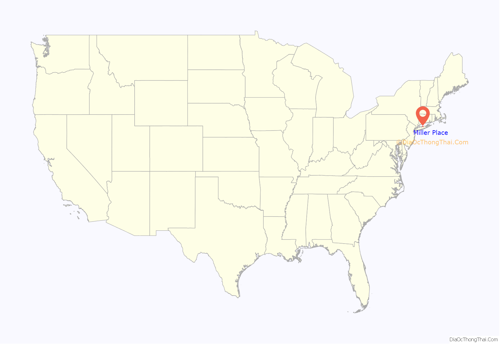
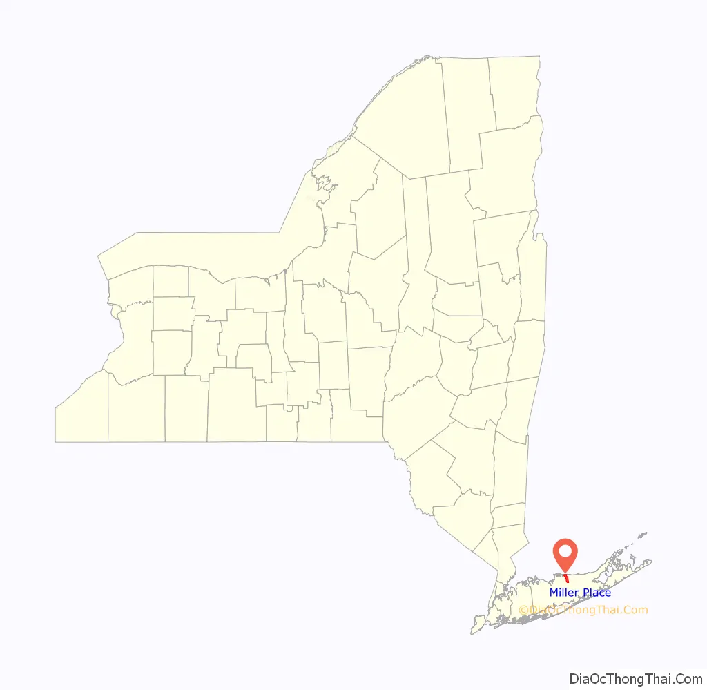
Miller Place is a hamlet and census-designated place (CDP) in the Town of Brookhaven, Suffolk County, New York, United States, on the North Shore of Long Island. Miller Place has been inhabited since the 17th century and is named for the Miller family that included many of its initial settlers. For most of its history, the community functioned as an agriculture-based society. Despite preserving much of its historic identity, changes in the 20th century have transitioned the hamlet into a desirable and densely populated suburban area. The population was 11,723 at the 2020 census.
The hamlet borders the areas of Sound Beach, Mount Sinai, Rocky Point, Middle Island and Coram. Miller Place and Mount Sinai have historically been linked, with residents sharing such institutions as the Mount Sinai Congregational Church, located on the hamlet’s border. The harborfront section of Port Jefferson, five miles to the west, serves as the primary commercial downtown for residents of both Miller Place and Mount Sinai.
| Name: | Miller Place CDP |
|---|---|
| LSAD Code: | 57 |
| LSAD Description: | CDP (suffix) |
| State: | New York |
| County: | Suffolk County |
| Elevation: | 131 ft (40 m) |
| Total Area: | 7.73 sq mi (20.01 km²) |
| Land Area: | 6.55 sq mi (16.96 km²) |
| Water Area: | 1.18 sq mi (3.05 km²) |
| Total Population: | 11,723 |
| Population Density: | 1,790.04/sq mi (691.12/km²) |
| ZIP code: | 11764 |
| Area code: | 631, 934 |
| FIPS code: | 3647306 |
| GNISfeature ID: | 0957319 |
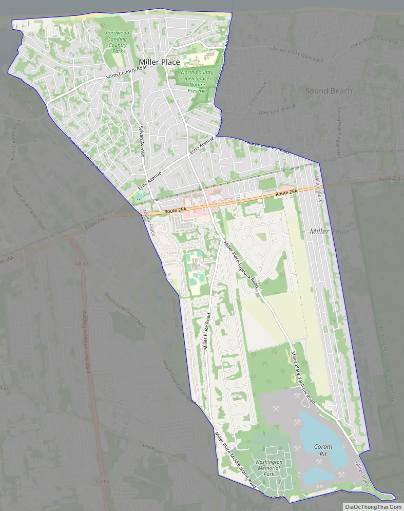
Online Interactive Map
Click on ![]() to view map in "full screen" mode.
to view map in "full screen" mode.
Miller Place location map. Where is Miller Place CDP?
History
Agricultural hamlet
The land that Miller Place occupies was purchased from the native Setalcott tribe in 1664 by settlers of Setauket. The parcel also included what would become Mount Sinai, an adjacent community of similar character with which Miller Place would share a variety of functions throughout its history.
The first known dwelling in the area was constructed in the 1660s by Captain John Scott, an important figure in Long Island’s early history. This house was named Braebourne and features on a map of the New England region credited to Scott, who served as a royal advisor and cartographer among other occupations. This abode, on the eastern side of Mount Sinai Harbor, was one of three houses John Scott commissioned, and the actual occupier is unknown.
While the original settler of Miller Place is unknown, the settling of the region is largely accredited to the original Miller family. In 1679, an East Hampton settler named Andrew Miller purchased a 30-acre (120,000 m) plot. Miller was a cooper by profession, and records indicate that he had emigrated from either Maidstone, England or Craigmillar, Scotland.
By the early 1700s, the community had become known as Miller’s Place. The Miller family expanded well into the 18th century and continually developed houses in the northern part of the hamlet. The Millers were in time joined by members of such families as the Helmes, Robinsons, Burnetts, Hawkins, Woodhulls, and Thomases. Many roads in the present hamlet have been named after historical families.
The oldest extant house is the home of William Miller, Andrew Miller’s grandson, composed in three sections between 1720 and 1816 at a prominent location on North Country Road. The hamlet’s many extant historical structures are centered on this thoroughfare, forming the core of the Miller Place Historic District. Listed on the National Register of Historic Places in 1976, it became the first historic district in the Town of Brookhaven. Separately listed is the Samuel Hopkins House.
The American Revolutionary War divided the town, with the majority siding with the Patriot cause but families being split across both lines. A number of midnight raids occurred, one of which resulted in the shooting of a teenaged Miller who had peered out of his window to check on the commotion. The march of Benjamin Tallmadge, who led eighty men to the victorious overthrow of a British stronghold at Manor St. George, traversed along the town’s western border.
In 1789, the neighboring communities of Miller Place and Mount Sinai organized a Congregational church on the town border. While the Mount Sinai Congregational Church building (an extant structure from 1807) is technically in Mount Sinai, the house for its minister was built in Miller Place and continues to be used for that purpose.
The first two public schools in the hamlet were established in 1813 and 1837. In 1834 the Miller Place Academy, a private school, was established under the leadership of a Yale graduate. Though the academy itself closed in 1868, it served as a public school from 1897 until the 1937 opening of what is now the North Country Road Middle School. The Miller Place Academy structure remains as one of the community’s symbols and currently houses a free library.
Resort town
In 1895 the hamlet became home to a station of the Long Island Rail Road, which was located near the present-day intersection of Sylvan and Echo avenues. It transported people to stops westward to Port Jefferson and New York City or eastward to Wading River. After the station was destroyed in a 1903 fire, a new one was built. However, this building was destroyed in 1934 by another fire, and the eastern railroad lines were soon abandoned. In 2013 an agreement was signed between local politicians and the Long Island Power Authority (LIPA), which currently manages the strip on which the railroad operated, to convert this land into a public bicycle trail.
In the latter 19th century, Miller Place became a popular summer resort location. This led to a building boom of beach-side bungalows, rustic log cabins, and commercial activities to accommodate the new seasonal residents. A barn-like building known as the Harbor House operated as a dormitory-style vacation house for young girls until it was destroyed in a 1962 fire. Camp Barstow, a Girl Scout camp near the beach, was active until 1980 and has since become public parkland.
Modern development
In the decades following World War II, the population of Miller Place greatly expanded, and the majority of beach cottages were repurposed as family homes.
A 2012 plan by the Town of Brookhaven aims to comprehensively manage Route 25a between Mount Sinai and Wading River under planning strategies counter to those of car-oriented mid-century suburbia. For Miller Place, it intends to transition the section at Echo and Sylvan Avenues into a traditional downtown center with new mixed-use development and an expanded Sylvan Avenue Park that would complement the current town post office and senior center. The plan additionally calls for the preservation of the DeLea Sod Farm, the largest agricultural parcel remaining on the Miller Place stretch of Route 25a.
Miller Place Road Map
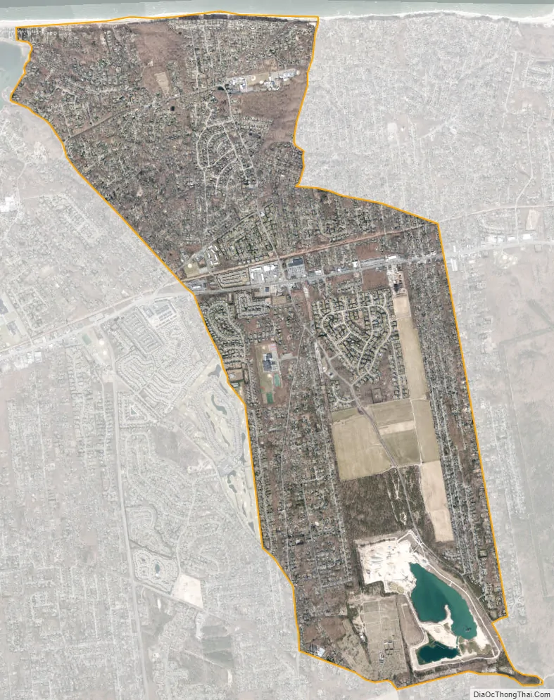
Miller Place city Satellite Map
Geography
Miller Place is located on Long Island’s North Shore and contains a 2-mile section of beach. It also hugs the east side of Mount Sinai Harbor, which it shares with neighboring Mount Sinai and Port Jefferson.
The area is hilly in some patches, mostly near the beach, but generally has desirable grass and trees. Though the soil is suitable for agriculture, desire for housing has led most farms to be developed into suburban housing communities or commercial locations.
See also
Map of New York State and its subdivision:- Albany
- Allegany
- Bronx
- Broome
- Cattaraugus
- Cayuga
- Chautauqua
- Chemung
- Chenango
- Clinton
- Columbia
- Cortland
- Delaware
- Dutchess
- Erie
- Essex
- Franklin
- Fulton
- Genesee
- Greene
- Hamilton
- Herkimer
- Jefferson
- Kings
- Lake Ontario
- Lewis
- Livingston
- Madison
- Monroe
- Montgomery
- Nassau
- New York
- Niagara
- Oneida
- Onondaga
- Ontario
- Orange
- Orleans
- Oswego
- Otsego
- Putnam
- Queens
- Rensselaer
- Richmond
- Rockland
- Saint Lawrence
- Saratoga
- Schenectady
- Schoharie
- Schuyler
- Seneca
- Steuben
- Suffolk
- Sullivan
- Tioga
- Tompkins
- Ulster
- Warren
- Washington
- Wayne
- Westchester
- Wyoming
- Yates
- Alabama
- Alaska
- Arizona
- Arkansas
- California
- Colorado
- Connecticut
- Delaware
- District of Columbia
- Florida
- Georgia
- Hawaii
- Idaho
- Illinois
- Indiana
- Iowa
- Kansas
- Kentucky
- Louisiana
- Maine
- Maryland
- Massachusetts
- Michigan
- Minnesota
- Mississippi
- Missouri
- Montana
- Nebraska
- Nevada
- New Hampshire
- New Jersey
- New Mexico
- New York
- North Carolina
- North Dakota
- Ohio
- Oklahoma
- Oregon
- Pennsylvania
- Rhode Island
- South Carolina
- South Dakota
- Tennessee
- Texas
- Utah
- Vermont
- Virginia
- Washington
- West Virginia
- Wisconsin
- Wyoming


