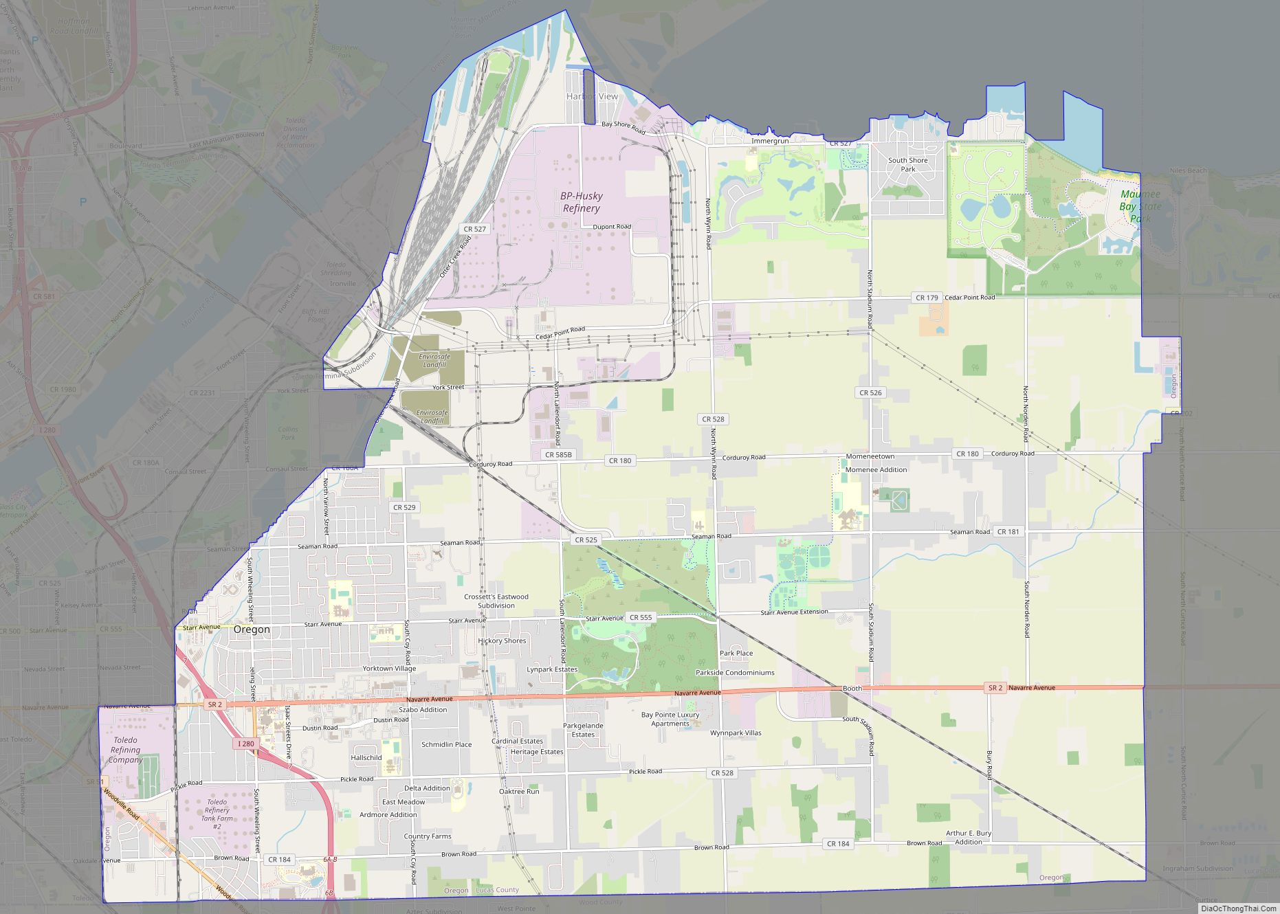
Oregon is a city in Lucas County, Ohio. It is a lakefront suburb of Toledo, located on Lake Erie, just east of the city. Oregon is known for its scenic lakefront, bike trails, and Maumee Bay State Park. The population was 19,950 at the 2020 Census. There are also two refineries and the Bayshore Power Plant within the city.
| Name: | Oregon city |
|---|---|
| LSAD Code: | 25 |
| LSAD Description: | city (suffix) |
| State: | Ohio |
| County: | Lucas County |
| Elevation: | 600 ft (183 m) |
| Total Area: | 28.90 sq mi (74.85 km²) |
| Land Area: | 28.52 sq mi (73.87 km²) |
| Water Area: | 0.38 sq mi (0.98 km²) |
| Total Population: | 19,950 |
| Population Density: | 699.46/sq mi (270.06/km²) |
| ZIP code: | 43605, 43616, 43618 |
| Area code: | 419/567 |
| FIPS code: | 3958730 |
| GNISfeature ID: | 1049043 |
| Website: | https://www.oregonohio.org/ |
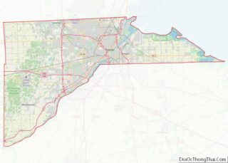
Online Interactive Map
Click on ![]() to view map in "full screen" mode.
to view map in "full screen" mode.
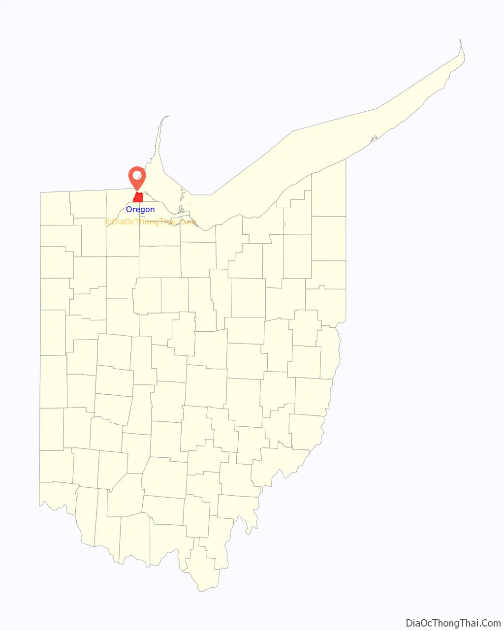
Oregon location map. Where is Oregon city?

History
Oregon was once part of the Great Black Swamp. The swamp area was rich with oak, hickory, ash, walnut, elm and maple trees. This led to the establishment of numerous sawmills and settlements. The harvested forests created rich farmland, but the area remained swampy and there was a need for storm drainage. Major ditches were constructed, usually along roadways that followed the path of old Indian trails. These ditches continue to provide storm drainage today, carrying storm water into Maumee Bay.
“The town was named Oregon by Pierre M. Irving, a nephew of Washington Irving, author of the popular book Astoria. This book attracted considerable interest in John Jacob Astor’s trading lands which were located in what is now the city of Oregon. The story, however, is an account of Astor’s fur trading in the territory of Oregon; but since the nephew was representing Astor’s interest in fur trading east of the Maumee River, he succeeded in having the town named Oregon. In 1838, Mr. Irving, accompanied by his wife, went to New York expecting to remain there for the summer; but for some reason he never returned.” Quoted in the “History of Oregon and Jerusalem” book, authored by Josephine Fassett.
The first government was Oregon Township, formed in 1838. The land was surveyed and there were public sales for settlements. The area that was the township, is now the City of Oregon, which is bounded on the west by the City of Toledo, the North by Maumee Bay/Lake Erie, on the east by Jerusalem Township (Lucas County) and on the South by the City of Northwood (Wood County). In 1856 the township took ownership of two cemeteries which remain owned by the City today.
The 1800s and 1900s saw the development of an extensive rail system. The Port of Toledo began operations on the south bank of the Maumee River in the early 1800s and developed port operations on the Maumee Bay in Oregon in 1955. These operations continue in the Northwest area of the city.
Because of the water, rail, and surface transportation access available in the city, two major refineries, British Petroleum (BP) and Sun Marketing opened in Oregon around the turn of the century. These two refineries have historically been two of the city’s largest employers..
The northwestern end of the city grew as an industrial center with a coal powered electrical generating facility and several chemical plants. Pipelines were laid to carry petroleum products to and from the port facilities and other regions. Buckeye Pipeline has the largest pipeline distribution system in Oregon.
As industrialization continued, commercial and residential growth followed. Generally, urban growth continued eastward from Interstate 280 – one of the nation’s first Interstates. Recently, residential growth has also occurred south of Maumee Bay in the waterfront areas and with perimeter development in the more rural areas.
In 1954 Oregon Township trustees sought to zone the area. At about the same time, City of Toledo officials sought to annex the northwest industrial area of Oregon Township. The annexation failed, and in 1957 there was an election for Oregon to become an incorporated city. The vote was 3,660 in favor and 2,925 opposed. A key issue in incorporation was to have Oregon own and operate a water and a wastewater plant.
The City of Oregon adopted their Charter in 1958. The new city adopted a slogan of “City of Opportunity.” In the mid 1980s, the city added Oregon on the Bay to the City of Opportunity. In 1959 voters approved an “earnings tax” now known as the municipal income tax. The water plant was constructed in 1964 and currently over 90% of the land in Oregon is serviced with waterlines. Plans for an estimated $17.9 million in improvements to the water plant continued in 1998. The original water plant was paid for by a combination of local and federal funds. The city also has a wastewater treatment plant, constructed in 1977, with local and federal funds, which can process up to eight million gallons per day. In 1997 a major upgrade to the wastewater plant was completed. Approximately one-third of the land in the city is serviced by sanitary sewer lines. The city’s water and wastewater operations also service portions of Jerusalem Township, northern Wood County and northwest Ottawa County.
The first Marco’s Pizza was established in Oregon in 1978.
Oregon Road Map
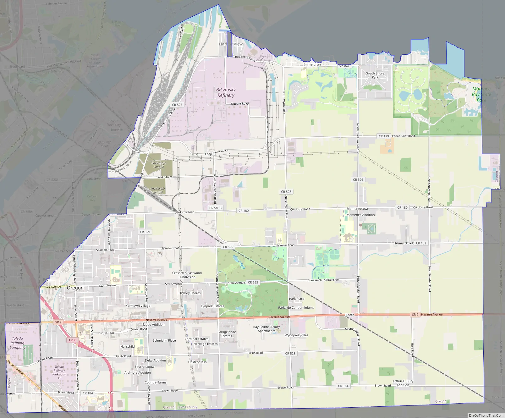
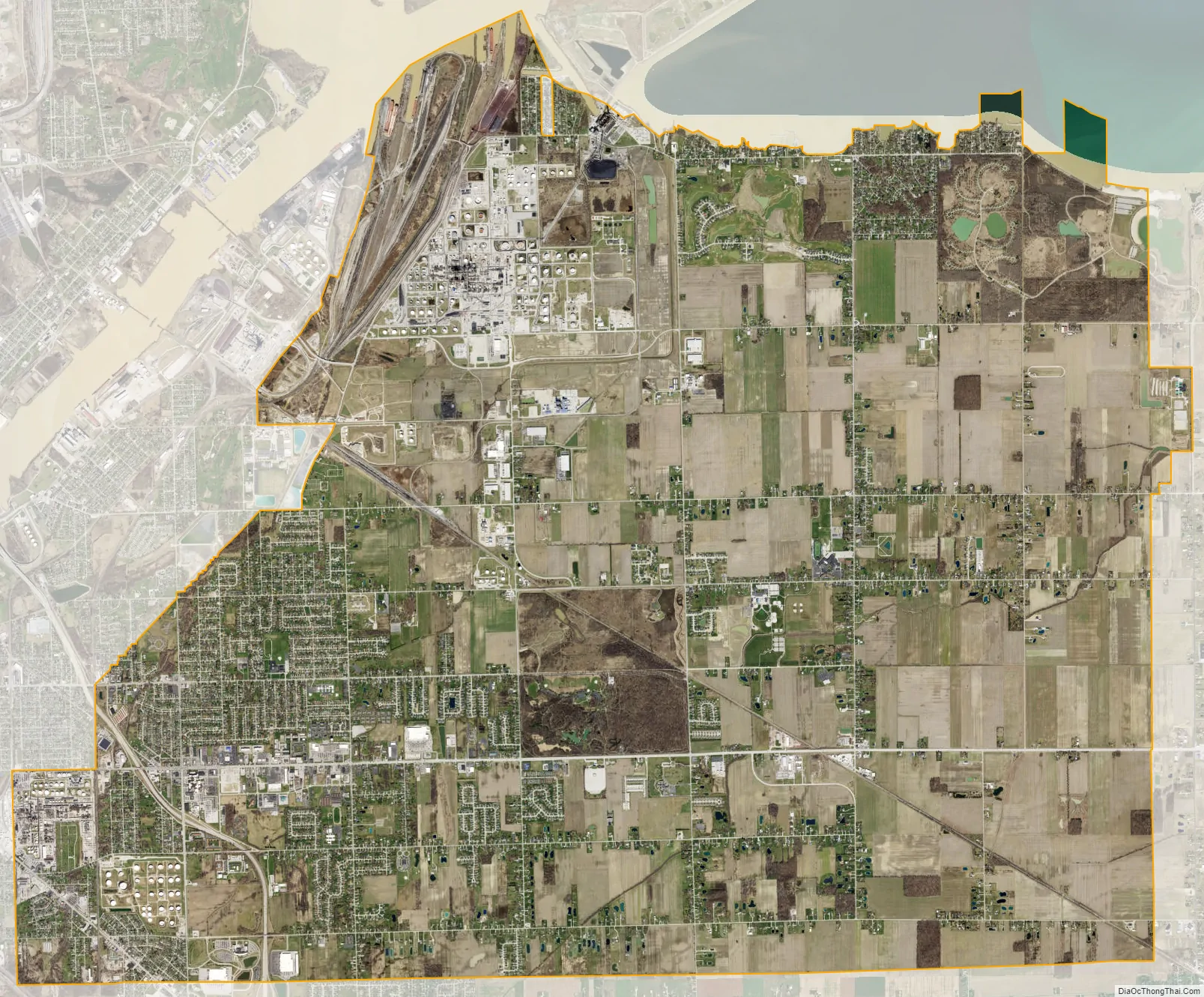
Oregon city Satellite Map
Geography
Oregon is located at 41°38′57″N 83°27′41″W / 41.64917°N 83.46139°W / 41.64917; -83.46139 (41.649094, -83.461514).
According to the United States Census Bureau, the city has a total area of 38.04 square miles (98.52 km), of which 29.98 square miles (77.65 km) is land and 8.06 square miles (20.88 km) is water.
See also
Map of Ohio State and its subdivision:- Adams
- Allen
- Ashland
- Ashtabula
- Athens
- Auglaize
- Belmont
- Brown
- Butler
- Carroll
- Champaign
- Clark
- Clermont
- Clinton
- Columbiana
- Coshocton
- Crawford
- Cuyahoga
- Darke
- Defiance
- Delaware
- Erie
- Fairfield
- Fayette
- Franklin
- Fulton
- Gallia
- Geauga
- Greene
- Guernsey
- Hamilton
- Hancock
- Hardin
- Harrison
- Henry
- Highland
- Hocking
- Holmes
- Huron
- Jackson
- Jefferson
- Knox
- Lake
- Lake Erie
- Lawrence
- Licking
- Logan
- Lorain
- Lucas
- Madison
- Mahoning
- Marion
- Medina
- Meigs
- Mercer
- Miami
- Monroe
- Montgomery
- Morgan
- Morrow
- Muskingum
- Noble
- Ottawa
- Paulding
- Perry
- Pickaway
- Pike
- Portage
- Preble
- Putnam
- Richland
- Ross
- Sandusky
- Scioto
- Seneca
- Shelby
- Stark
- Summit
- Trumbull
- Tuscarawas
- Union
- Van Wert
- Vinton
- Warren
- Washington
- Wayne
- Williams
- Wood
- Wyandot
- Alabama
- Alaska
- Arizona
- Arkansas
- California
- Colorado
- Connecticut
- Delaware
- District of Columbia
- Florida
- Georgia
- Hawaii
- Idaho
- Illinois
- Indiana
- Iowa
- Kansas
- Kentucky
- Louisiana
- Maine
- Maryland
- Massachusetts
- Michigan
- Minnesota
- Mississippi
- Missouri
- Montana
- Nebraska
- Nevada
- New Hampshire
- New Jersey
- New Mexico
- New York
- North Carolina
- North Dakota
- Ohio
- Oklahoma
- Oregon
- Pennsylvania
- Rhode Island
- South Carolina
- South Dakota
- Tennessee
- Texas
- Utah
- Vermont
- Virginia
- Washington
- West Virginia
- Wisconsin
- Wyoming