Lannon is a village in Waukesha County, Wisconsin, United States. The population was 1,355 at the 2020 census. Lannon is a part of the Milwaukee metropolitan area.
| Name: | Lannon village |
|---|---|
| LSAD Code: | 47 |
| LSAD Description: | village (suffix) |
| State: | Wisconsin |
| County: | Waukesha County |
| Elevation: | 915 ft (279 m) |
| Total Area: | 2.49 sq mi (6.45 km²) |
| Land Area: | 2.47 sq mi (6.40 km²) |
| Water Area: | 0.02 sq mi (0.05 km²) |
| Total Population: | 1,355 |
| Population Density: | 498.38/sq mi (192.41/km²) |
| ZIP code: | 53046 |
| Area code: | 262 |
| FIPS code: | 5542450 |
| GNISfeature ID: | 1567839 |
| Website: | www.villageoflannon.com |
Online Interactive Map
Click on ![]() to view map in "full screen" mode.
to view map in "full screen" mode.
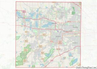
Lannon location map. Where is Lannon village?


History
The village is named for William Lannon, who settled here with his bride in 1834. The area was granted the postal designation of “Lannon” in 1890. In 1930 the Village of Lannon was incorporated out of parts of the Town of Menomonee.
Lannon stone
Lannon stone, a type of limestone or dolomite, is named for the town, as it was quarried here. John Halquist built one of the state’s largest stone companies from Lannon stone first in Sussex, Wisconsin, and then in several locations.
Lannon stone was the major source of stone for many cities in Wisconsin and for Chicago. It was widely used to provide a stone veneer on bridges.
Lannon stone is variously asserted to be limestone rather than dolomite, or to be limestone which is also known as dolomite. Menonomee Park has been described as an excellent place to photograph Lannon stone.
Lannon Road Map

Lannon city Satellite Map

Geography
Lannon is located at 43°9′1″N 88°9′52″W / 43.15028°N 88.16444°W / 43.15028; -88.16444 (43.150288, -88.164568).
According to the United States Census Bureau, the village has a total area of 2.46 square miles (6.37 km), of which, 2.44 square miles (6.32 km) is land and 0.02 square miles (0.05 km) is water.
See also
Map of Wisconsin State and its subdivision:- Adams
- Ashland
- Barron
- Bayfield
- Brown
- Buffalo
- Burnett
- Calumet
- Chippewa
- Clark
- Columbia
- Crawford
- Dane
- Dodge
- Door
- Douglas
- Dunn
- Eau Claire
- Florence
- Fond du Lac
- Forest
- Grant
- Green
- Green Lake
- Iowa
- Iron
- Jackson
- Jefferson
- Juneau
- Kenosha
- Kewaunee
- La Crosse
- Lafayette
- Lake Michigan
- Lake Superior
- Langlade
- Lincoln
- Manitowoc
- Marathon
- Marinette
- Marquette
- Menominee
- Milwaukee
- Monroe
- Oconto
- Oneida
- Outagamie
- Ozaukee
- Pepin
- Pierce
- Polk
- Portage
- Price
- Racine
- Richland
- Rock
- Rusk
- Saint Croix
- Sauk
- Sawyer
- Shawano
- Sheboygan
- Taylor
- Trempealeau
- Vernon
- Vilas
- Walworth
- Washburn
- Washington
- Waukesha
- Waupaca
- Waushara
- Winnebago
- Wood
- Alabama
- Alaska
- Arizona
- Arkansas
- California
- Colorado
- Connecticut
- Delaware
- District of Columbia
- Florida
- Georgia
- Hawaii
- Idaho
- Illinois
- Indiana
- Iowa
- Kansas
- Kentucky
- Louisiana
- Maine
- Maryland
- Massachusetts
- Michigan
- Minnesota
- Mississippi
- Missouri
- Montana
- Nebraska
- Nevada
- New Hampshire
- New Jersey
- New Mexico
- New York
- North Carolina
- North Dakota
- Ohio
- Oklahoma
- Oregon
- Pennsylvania
- Rhode Island
- South Carolina
- South Dakota
- Tennessee
- Texas
- Utah
- Vermont
- Virginia
- Washington
- West Virginia
- Wisconsin
- Wyoming