Salinas (/səˈliːnəs/; Spanish for “Salt Marsh or Salt Flats”) is a city in California and the county seat of Monterey County. With a population of 163,542 in the 2020 Census, Salinas is the most populous city in Monterey County. Salinas is an urban area located along the eastern limits of the Monterey Bay Area, lying just south of the San Francisco Bay Area and 10 miles (16 km) southeast of the mouth of the Salinas River. The city is located at the mouth of the Salinas Valley, about eight miles (13 km) from the Pacific Ocean, and it has a climate more influenced by the ocean than the interior.
Salinas serves as the main business, governmental, and industrial center of the region. The marine climate is ideal for the floral industry, grape vineyards, and vegetable growers. Salinas is known as the “Salad Bowl of the World” for its large, vibrant agriculture industry.
It was the hometown of writer and Nobel laureate John Steinbeck (1902–68), who set many of his stories in the Salinas Valley and Monterey. Salinas has a high Hispanic proportion, which at 79.6%, is the highest proportion of Hispanic Americans out of any city in California, and 8th largest overall in the nation. The city also has a sizable Asian-American population, with a large and historic Filipino population. The city once also had the 2nd biggest Chinatown in the nation behind only San Francisco.
| Name: | Salinas city |
|---|---|
| LSAD Code: | 25 |
| LSAD Description: | city (suffix) |
| State: | California |
| County: | Monterey County |
| Incorporated: | March 4, 1874 |
| Elevation: | 52 ft (16 m) |
| Land Area: | 23.42 sq mi (60.66 km²) |
| Water Area: | 0.03 sq mi (0.08 km²) 0.16% |
| Population Density: | 7,000/sq mi (2,700/km²) |
| Area code: | 831 |
| FIPS code: | 0664224 |
| Website: | www.cityofsalinas.org |
Online Interactive Map
Click on ![]() to view map in "full screen" mode.
to view map in "full screen" mode.
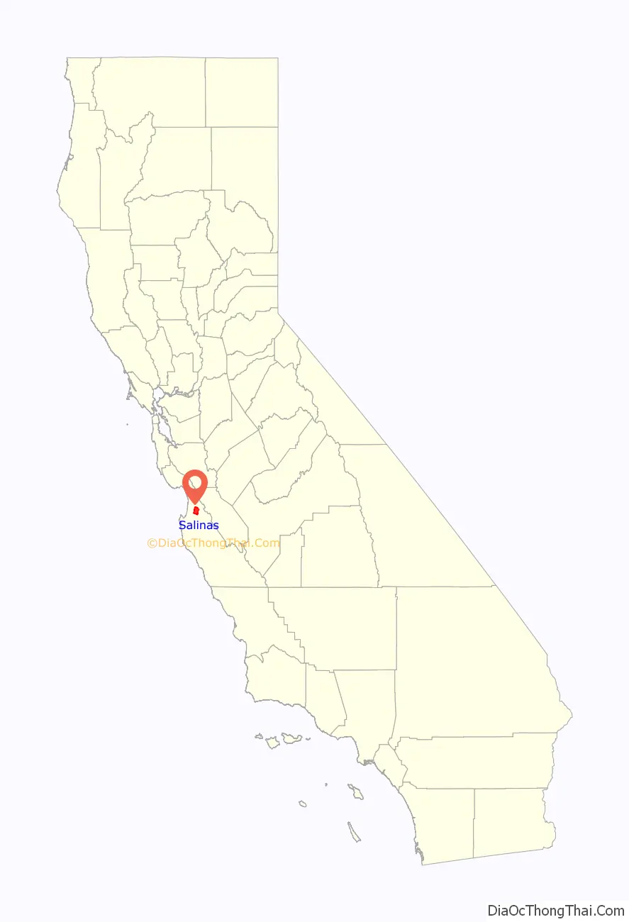
Salinas location map. Where is Salinas city?

History
The land that Salinas sits on is thought to have been settled by Native Americans known as the Esselen prior to 200 AD. Between 200 and 500 AD, they were displaced by the Rumsen group of Ohlone speaking people. The Rumsen-Ohlone remained as the inhabitants of the area for approximately another 1,200 years, and in the 1700s, were the group of native inhabitants contacted and recorded by the first Spanish explorers of the Salinas area.
Upon the arrival of the Spanish, large Spanish land grants were initially issued for the Catholic Missions and also as bonuses to soldiers. Later on after Mexican independence, smaller land grants continued to be issued for ranchos where mostly cattle were grazed. One of the many land grants was the Rancho Las Salinas land grant, part of which included the area of modern-day Salinas. As a result of the many new cattle ranches, a thriving trade eventually developed in cattle hide shipments, shipping primarily out of the Port of Monterey.
In 1848 California officially became a part of the United States of America. This transition followed several years of battles in the Salinas area with John Fremont flying the American flag on the highest peak of the Gabilan Mountains and claiming California for the United States. Before the transition to American administration, Monterey had been the capital of California. For a short while after the transition, California was ruled by martial law. On September 9, 1850, California was admitted to the Union and became a State, celebrated as California Admission Day.
In the 1850s a junction of two main stage coach routes was located 18 miles (29 km) east of Monterey and along the big bend of what is locally referred to as the Alisal Slough. In 1854, six years after becoming a part of the United States, a group of American settlers living in the vicinity of this route-junction opened a post office at the junction, naming their town “Salinas,” apparently a reference to the original “Rancho Las Salinas” name for the area, which in turn was named in Spanish for the salt marshes of the area around the central Salinas slough, which was drained. Soon thereafter, in 1856, a traveler’s inn called the Halfway House was opened at that junction in Salinas. (The nearby Salinas River, was apparently only later named by an American cartographer, after the nearest town of Salinas in 1858. Previously that river had gone by the name: “Rio de Monterey.”). The streets of Salinas were laid out in 1867, and the town was incorporated in 1874.
The conversion of grazing land to crops and the coming of the rail road in 1868 to transport goods and people was a major turning point in the history and economic advancement of Salinas. Dry farming of wheat, barley, and other grains as well as potatoes and mustard seed was common in the 1800s. Chinese labor drained thousands of acres of swampland to become productive farmland, and as much early farm labor was done by Chinese immigrants, Salinas boasted the second largest Chinatown in the state, slightly smaller than San Francisco. Irrigation changed farming in Salinas to mainly row crops of root vegetables, grapes and sugar beets. Many major vegetable producers placed their headquarters in Salinas. Driven by the profitable agricultural industry, Salinas had the highest per capita income of any city in the United States in 1924.
During World War II, the Salinas Rodeo Grounds was one of the locations used as a temporary detention camp for citizens and immigrant residents of Japanese ancestry, before they were relocated to more permanent and remote facilities. One of seventeen such sites overseen by the Wartime Civilian Control Administration, the Salinas Assembly Center was built after President Roosevelt issued Executive Order 9066, authorizing the removal and confinement of Japanese Americans living on the West Coast. The camp opened on April 27, 1942, and held a total of 3,608 people before closing two months later on July 4.
Following World War II major urban and suburban development converted much farmland to city. The city experienced two particularly strong growth spurts in the 1950s and 1960s, and again in the 1990s and early 2000s. Aerial photographic interpretation indicate such major conversion of cropland to urban uses over the time period 1956 to 1968, while the city annexed the adjacent communities of Alisal and Santa Rita during this time. The Harden Ranch, Creekbridge and Williams Ranch neighborhoods constituting much of the city’s North-East were built almost exclusively between 1990 and 2004.
Salinas was also the birthplace of writer and Nobel Prize laureate John Steinbeck. The historic downtown, known as Oldtown Salinas, features much fine Victorian architecture, and is home to the National Steinbeck Center, the Steinbeck House and the John Steinbeck Library.
Major development took place in the 1990s, with the construction of Creekbridge, Williams Ranch, and Harden Ranch.
Salinas Road Map

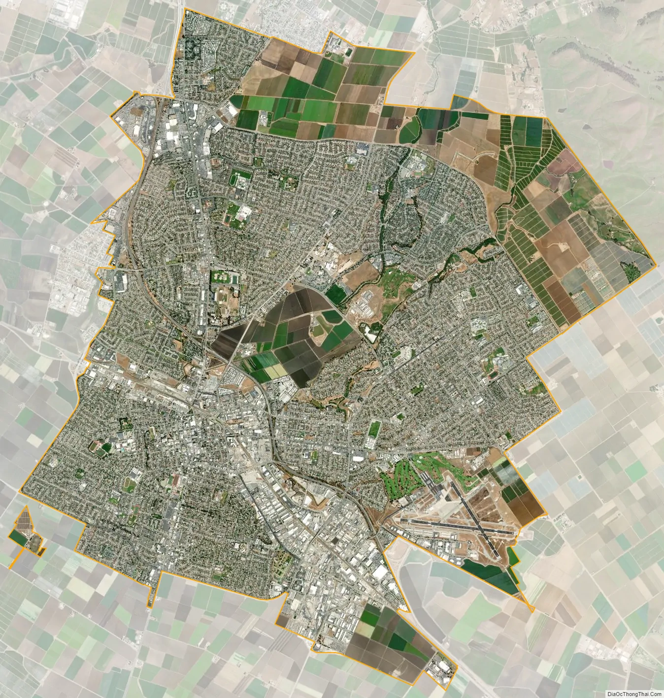
Salinas city Satellite Map
Geography
According to the United States Census Bureau, the city has a total area of 23.2 square miles (60 km), 99.84% of it land and 0.16% of it water.
Prior to mass agricultural and urban development, much of the city consisted of rolling hills bisected by wooded creeks and interspersed with marsh land. Today, the city is located mostly on leveled ground, with some rolling hills and wooded gulches with creeks remaining in the north-eastern Creekbridge and Williams Ranch neighborhoods, as well as the Laurel Heights section of East Salinas. The natural ecosystems accompanying the area’s topography and environment have been recreated in Natividad Creek Park and adjacent Upper Carr Lake.
The city rests about 18 meters (59 feet) above sea level, and it is located roughly eight miles from the Pacific Ocean. The Gabilan and Santa Lucia mountain ranges border the Salinas Valley to the east and to the west, respectively. Both mountain ranges and the Salinas Valley run approximately 90 miles (145 km) south-east from Salinas towards King City.
The Salinas River runs the length of the Salinas Valley and empties into the Pacific Ocean at the center of the Monterey Bay. During the summer months the river flows partially underground and it is this extensive underground aquifer that allows for irrigation of cropland in an area without much annual rainfall.
Climate
Salinas has cool and moderate temperatures, due to the “natural air conditioner” that conveys ocean air and fog from the Monterey Bay to Salinas, while towns to the north and south of Salinas experience hotter summers, as mountains block the ocean air. Thus, Salinas weather is closer to that of the Central Coast of California, rather than that of inland valleys, and thus has a mild Mediterranean climate (Köppen Csb) with typical daily highs ranging from 62.4 °F (16.9 °C) in December to 74.7 °F (23.7 °C) in September. The record highest temperature was 107 °F (42 °C) on September 2, 2017. The record lowest temperature was 22 °F (−6 °C) on January 12, 1963 and January 13, 2007. Annually, there are an average of 5.8 days with 90 °F (32 °C)+ highs, and an average of 7.1 days with lows reaching the freezing mark or lower.
Between 1958 and 2018, the coldest measured daytime high in Salinas was 42 °F (6 °C) on December 21–22, 1990. The warmest night during the station’s operation was 67 °F (19 °C) on September 2, 2017.
In 2015 Salinas was in the top ten American cities for cleanest air quality, It is thought that the offshore marine layer generates winds that blow smog further inland.
The difference between ocean and air temperature also tends to create heavy morning fog during the summer months, known as the marine layer, driven by an onshore wind created by the local high pressure sunny portions of the Salinas Valley, which extend north and south from Salinas and the Bay.
The average annual rainfall for the city is approximately 15.38 inches or 390.7 millimetres. The wettest “rain year” since records at the present station began in 1959 was from July 1997 to June 1998 with 34.63 inches (879.6 mm) of precipitation, and the driest from July 1971 to June 1972 with 7.29 inches (185.2 mm). The most precipitation in one month was 11.10 inches (282 mm) in February 1998. The record maximum 24-hour precipitation was 2.96 inches (75 mm) on January 23, 2000. Occasionally, there is snowfall on the peaks of the Gabilan and Santa Lucia mountain ranges, but snow in the city itself is extremely rare, occurring about once every 5 to 15 years on average. An inch of snow fell in Salinas on February 26, 2011.
See also
Map of California State and its subdivision:- Alameda
- Alpine
- Amador
- Butte
- Calaveras
- Colusa
- Contra Costa
- Del Norte
- El Dorado
- Fresno
- Glenn
- Humboldt
- Imperial
- Inyo
- Kern
- Kings
- Lake
- Lassen
- Los Angeles
- Madera
- Marin
- Mariposa
- Mendocino
- Merced
- Modoc
- Mono
- Monterey
- Napa
- Nevada
- Orange
- Placer
- Plumas
- Riverside
- Sacramento
- San Benito
- San Bernardino
- San Diego
- San Francisco
- San Joaquin
- San Luis Obispo
- San Mateo
- Santa Barbara
- Santa Clara
- Santa Cruz
- Shasta
- Sierra
- Siskiyou
- Solano
- Sonoma
- Stanislaus
- Sutter
- Tehama
- Trinity
- Tulare
- Tuolumne
- Ventura
- Yolo
- Yuba
- Alabama
- Alaska
- Arizona
- Arkansas
- California
- Colorado
- Connecticut
- Delaware
- District of Columbia
- Florida
- Georgia
- Hawaii
- Idaho
- Illinois
- Indiana
- Iowa
- Kansas
- Kentucky
- Louisiana
- Maine
- Maryland
- Massachusetts
- Michigan
- Minnesota
- Mississippi
- Missouri
- Montana
- Nebraska
- Nevada
- New Hampshire
- New Jersey
- New Mexico
- New York
- North Carolina
- North Dakota
- Ohio
- Oklahoma
- Oregon
- Pennsylvania
- Rhode Island
- South Carolina
- South Dakota
- Tennessee
- Texas
- Utah
- Vermont
- Virginia
- Washington
- West Virginia
- Wisconsin
- Wyoming


