Trinidad (Spanish for “Trinity”; Yurok: Chuerey) is a seaside city in Humboldt County, located on the Pacific Ocean 8 miles (13 km) north of the Arcata-Eureka Airport and 15 miles (24 km) north of the college town of Arcata. Trinidad is noted for its coastline with ten public beaches and offshore rocks, part of the California Coastal National Monument, of which Trinidad is a Gateway City. Fishing operations related to Trinidad Harbor are vital to both local tourism and commercial fishery interests in the region. Situated at an elevation of 174 feet (53 m) above its own North Coast harbor, Trinidad is one of California‘s smallest incorporated cities by population (367 residents in 2010, up from 311 residents in 2000).
| Name: | Trinidad city |
|---|---|
| LSAD Code: | 25 |
| LSAD Description: | city (suffix) |
| State: | California |
| County: | Humboldt County |
| Incorporated: | November 7, 1870 |
| Elevation: | 174 ft (53 m) |
| Total Area: | 0.67 sq mi (1.74 km²) |
| Land Area: | 0.48 sq mi (1.26 km²) |
| Water Area: | 0.19 sq mi (0.48 km²) 27.75% |
| Total Population: | 307 |
| Population Density: | 731.96/sq mi (282.68/km²) |
| ZIP code: | 95570 |
| Area code: | 707 |
| FIPS code: | 0680448 |
| Website: | trinidad.ca.gov |
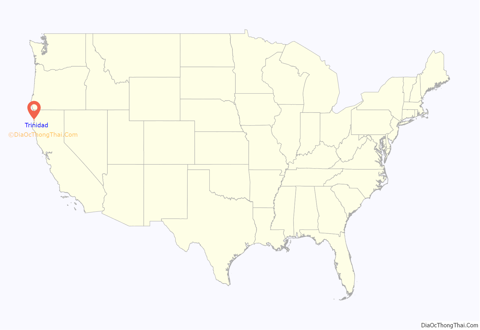
Online Interactive Map
Click on ![]() to view map in "full screen" mode.
to view map in "full screen" mode.
Trinidad location map. Where is Trinidad city?

History
Before 1700 AD, Yurok people established the village of Tsurai on bluffs overlooking Trinidad Bay. The first European sighting of Trinidad Harbor was by the Manila galleon captain Sebastian Rodriguez Cermeño, who did not make landfall. The next visit was by Bruno de Heceta and Juan Francisco de la Bodega y Quadra of the Spanish Navy. Their two ships anchored in Trinidad Bay on June 9, 1775. On 11 June, which was Trinity Sunday, a formal act of possession was conducted. At the place where a wooden cross was erected stands a carved stone cross bearing the inscription, “Carolus III Dei G. Hyspaniorum Rex” (“in the name of King Carlos of Spain”). The area was named “La Santisima Trinidad.”
Settlers arrived on the James R. Whitting in 1850 and founded the town, renamed Warnersville in honor of R.V. Warner, one of the settlers. The first post office opened in Trinidad in 1851.
Trinidad was the original county seat of the eponymous Trinity County from 1850 to 1851, and of Klamath County, one of California’s original counties, from 1851 to 1854. At that time Trinidad became part of the newly created Humboldt County after its creation in 1853, with its county seat in Eureka. Klamath County was finally dissolved in 1874.
During the American Civil War, from July to October 1863, California volunteers fighting the local Indians in the Bald Hills War were stationed in the town, in Trinidad Camp, to protect it and the coast road from Indian raids, until they were moved four miles north to Camp Gilmore. Trinidad was incorporated in 1870 as a City of the State of California, USA.
A whaling station owned by the California Sea Products Company operated in Trinidad from 1920 to 1926. 1140 whales were killed and processed in that time.
Trinidad resident Henry A. Boyes was a first sergeant with the 5th Marines in World War II; his service was described by Eugene Sledge in the book, With the Old Breed: At Peleliu and Okinawa.
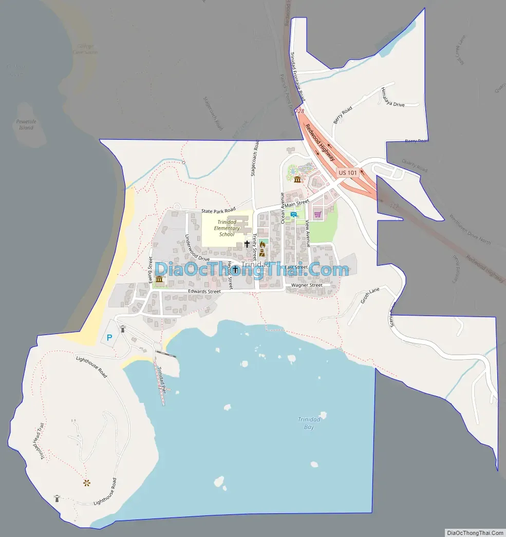
Trinidad Road Map
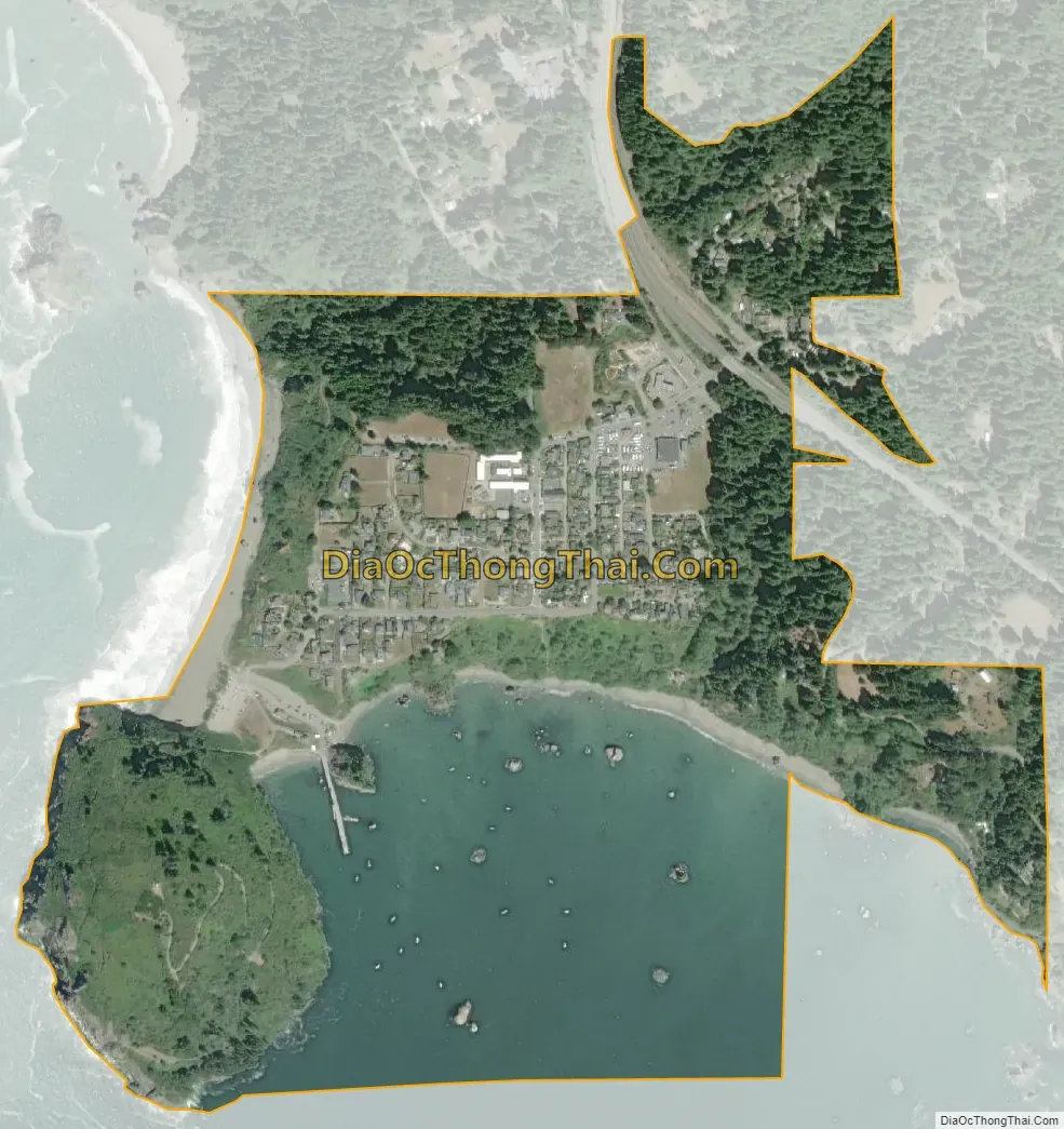
Trinidad city Satellite Map
Geography
Climate
Trinidad has an oceanic climate, bordering on a warm-summer Mediterranean climate (csb) and is relatively temperate compared with inland areas. Annual temperatures range from approximately 37.1 to 74.2 °F (2.8 to 23.4 °C). Winter months are rainy with the average amount being around 50 inches (130 cm), Although rain falls in all months of the year, it is less pronounced in the summertime. Spring and fall cold fronts often form advection fog which pushes the marine layer towards the coast. In summer, low pressure troughs produced by intense heating inland can create strong pressure gradients pulling the marine layer ashore. Summer fogs, moderate precipitation, and mild temperatures are characteristic of Northern California coastal forests ecoregion and are vital to the growth of local Coast Redwood. Protected stands of old growth redwoods can be visited 20 miles (32 km) north of Trinidad, in Redwood National and State Parks.
See also
Map of California State and its subdivision:- Alameda
- Alpine
- Amador
- Butte
- Calaveras
- Colusa
- Contra Costa
- Del Norte
- El Dorado
- Fresno
- Glenn
- Humboldt
- Imperial
- Inyo
- Kern
- Kings
- Lake
- Lassen
- Los Angeles
- Madera
- Marin
- Mariposa
- Mendocino
- Merced
- Modoc
- Mono
- Monterey
- Napa
- Nevada
- Orange
- Placer
- Plumas
- Riverside
- Sacramento
- San Benito
- San Bernardino
- San Diego
- San Francisco
- San Joaquin
- San Luis Obispo
- San Mateo
- Santa Barbara
- Santa Clara
- Santa Cruz
- Shasta
- Sierra
- Siskiyou
- Solano
- Sonoma
- Stanislaus
- Sutter
- Tehama
- Trinity
- Tulare
- Tuolumne
- Ventura
- Yolo
- Yuba
- Alabama
- Alaska
- Arizona
- Arkansas
- California
- Colorado
- Connecticut
- Delaware
- District of Columbia
- Florida
- Georgia
- Hawaii
- Idaho
- Illinois
- Indiana
- Iowa
- Kansas
- Kentucky
- Louisiana
- Maine
- Maryland
- Massachusetts
- Michigan
- Minnesota
- Mississippi
- Missouri
- Montana
- Nebraska
- Nevada
- New Hampshire
- New Jersey
- New Mexico
- New York
- North Carolina
- North Dakota
- Ohio
- Oklahoma
- Oregon
- Pennsylvania
- Rhode Island
- South Carolina
- South Dakota
- Tennessee
- Texas
- Utah
- Vermont
- Virginia
- Washington
- West Virginia
- Wisconsin
- Wyoming


