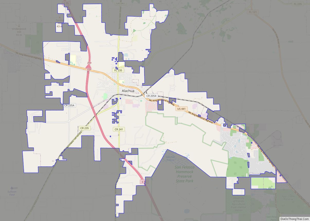
Alachua (/əˈlætʃueɪ/ (listen) ə-LATCH-oo-ay) is the second-largest city in Alachua County, Florida and the third-largest in North Central Florida. According to the 2020 census, the city’s population was 10,574. The city is part of the Gainesville metropolitan area, which had a population of 339,247 in 2020.
Alachua has one of the largest bio and life sciences sectors in Florida and is the site for the Santa Fe College Perry Center for Emerging Technologies.
| Name: | Alachua city |
|---|---|
| LSAD Code: | 25 |
| LSAD Description: | city (suffix) |
| State: | Florida |
| County: | Alachua County |
| Elevation: | 138 ft (42 m) |
| Total Area: | 36.56 sq mi (94.70 km²) |
| Land Area: | 36.20 sq mi (93.75 km²) |
| Water Area: | 0.37 sq mi (0.95 km²) 0.11% |
| Total Population: | 10,574 |
| Population Density: | 292.12/sq mi (112.79/km²) |
| ZIP code: | 32615-32616 |
| FIPS code: | 1200375 |
| GNISfeature ID: | 0307629 |
| Website: | www.cityofalachua.com |
Online Interactive Map
Click on ![]() to view map in "full screen" mode.
to view map in "full screen" mode.
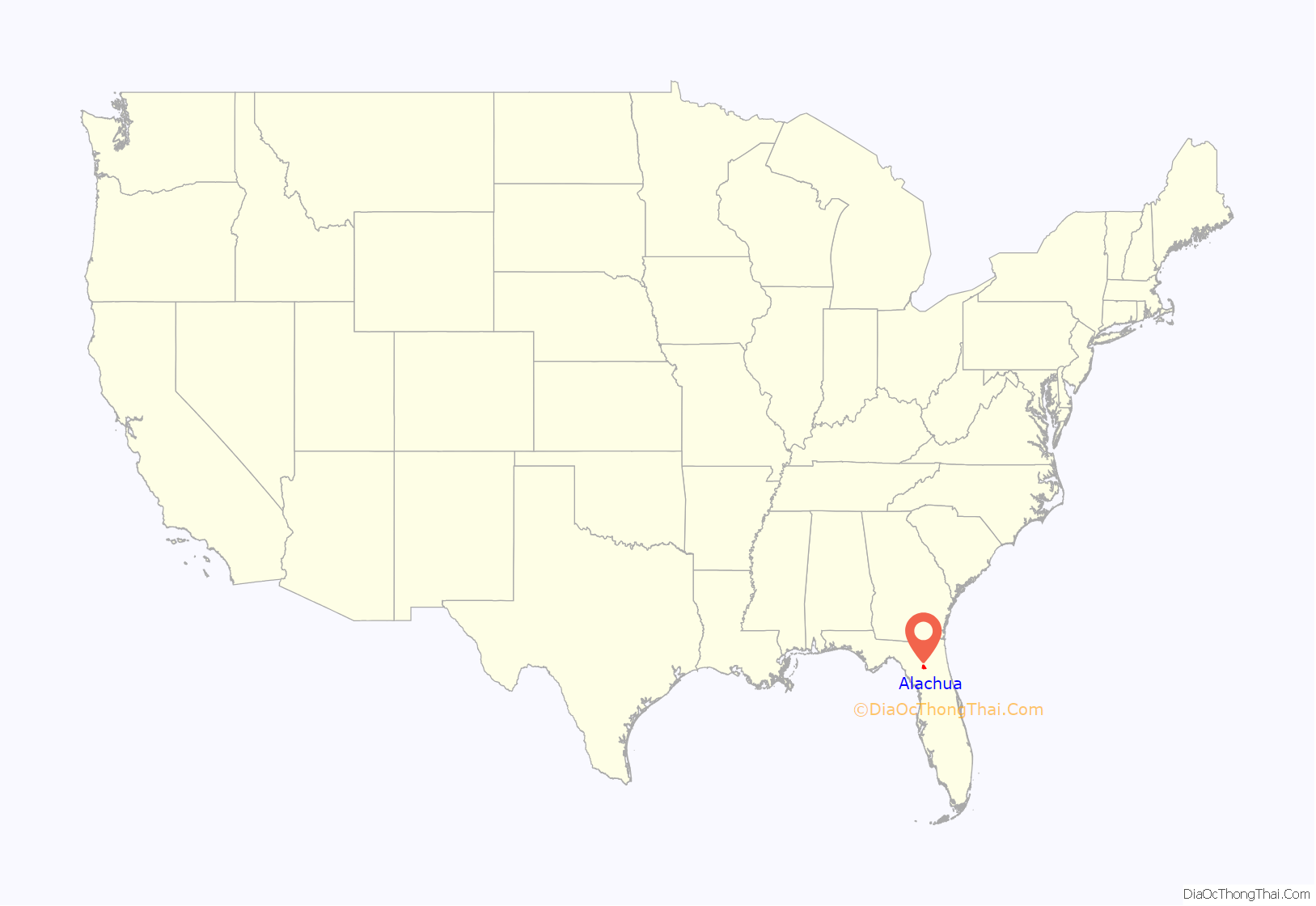
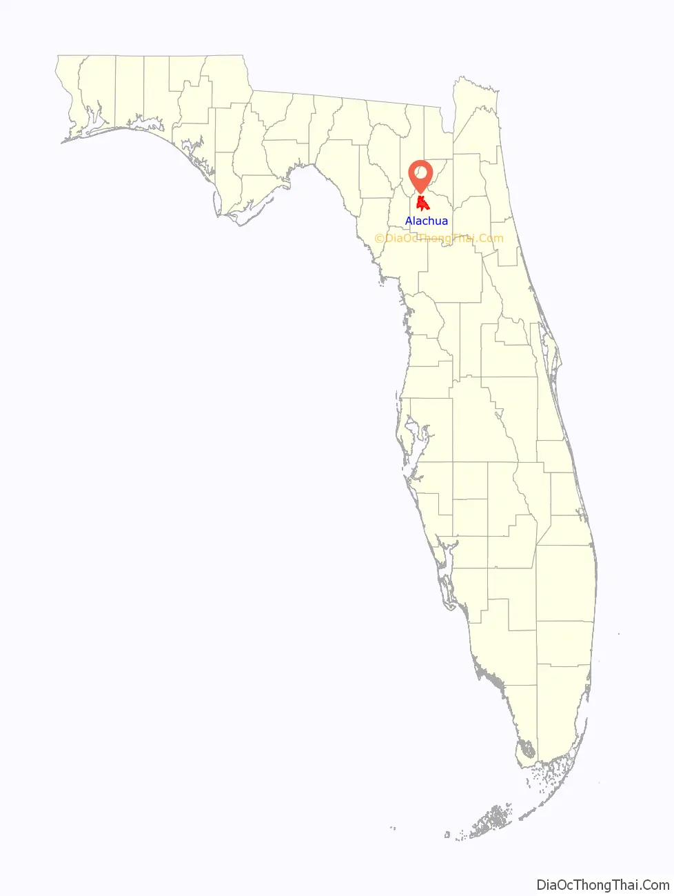
Alachua location map. Where is Alachua city?
History
Evidence of habitation by pre-historic Paleo-Indians exists in several documented locations within the San Felasco Hammock Preserve State Park. In the historic era, the primary town for the Potano tribe that lived throughout North Central Florida also was within San Felasco. This town became the site of the first Spanish doctrina (mission with a resident priest) in the Florida interior in 1606, Mission San Francisco de Potano, and it was the last to be abandoned by the Spanish in the early 1700s due to raids instigated by the British. Nearby to the north along the Santa Fe River was another mission, Santa Fe de Toloca, which was part of the mission chain stretching from St. Augustine to Pensacola.
The area slightly northeast of the current City of Alachua was among the first settled by Americans in Florida in the early 19th Century. Many participants in the Patriot War that attempted to force the annexation of Florida to the United States from the Spanish resided there, including the Dell family. The exact date of first settlement is unknown, but the community first known as Dell’s Courthouse then later renamed as Newnansville is, along with Micanopy, the oldest distinctly American settlement in the State. The Methodist church that started with the Dell family continues to this day and is the oldest in the State, First United Methodist Church of Alachua.
Newnansville became the second county seat of Alachua County and one of the central locations for activity during the Second Seminole War, with the inclusion of Fort Gilleland within its borders. The influx of settlers seeking refuge within the city temporarily increased the population between 1,500 to 2,000, making it one of the largest cities in the State.
When the first cross-state railroad, the Florida Railroad, bypassed Newnansville in the early 1850s, members of the County Commission voted by a slim margin to relocate the county seat along the rail line in a centrally-located, new city to be called Gainesville. Newnansville began to lose influence and, when the Savannah, Florida and Western Railroad bypassed the city by about 1.5 miles to the southwest in the early 1880s, citizens began to relocate along the new rail line (eventually abandoning Newnansville and turning it into a ghost town) and established the City of Alachua.
Alachua was founded in 1884, with its post office opening in 1887. It was incorporated as a city on 12 April 1905, at which time it had a population of 526 people. A third rail line passed through the new city, and a booming cotton industry helped support the building of several lavish Queen Anne-style homes and brick businesses along Main Street at the turn of the century.
Alachua stagnated when the boll weevil nearly destroyed the American cotton industry in 1919-1920, then through the Great Depression in the 1930s. The main industries through the middle of the Twentieth Century were lumber and food processing, notably through Duke Lumber Company and Copeland Sausage Company, respectively.
Interstate 75 passed slightly to the west of Downtown Alachua when it was built in the 1960s, providing new access and economic opportunity. Alachua faced another downturn with the closing of Copeland Sausage in 1976, and by the 1980s the buildings and businesses on Main Street were in poor shape. A concerted effort by the citizens and local government of Alachua focused on rehabilitating Downtown, and the construction of Progress Corporate Park with the University of Florida led to the creation of the UF Innovate Sid Martin Biotech Incubator which has resulted in the formation of one of the State’s largest bio and life science business sectors.
Alachua Road Map
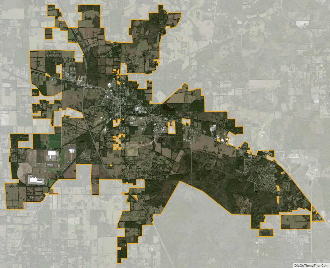
Alachua city Satellite Map
Geography
Alachua is located at 29°46′45″N 82°28′47″W / 29.77917°N 82.47972°W / 29.77917; -82.47972 (29.779286, –82.479849). According to the United States Census Bureau, the city has a total area of 35.1 square miles (91.0 km), of which 34.7 square miles (90.0 km) is land and 0.39 square miles (1.0 km) (1.08%) is water.
Cityscape
Alachua’s Main Street runs along a North-South direction and is the heart of the City of Alachua Downtown Historic District, which is listed on the National Register of Historic Places. The rest of the Historic District lies mainly to the west of Main Street and consists of residential structures built primarily in the early 20th Century. Main Street is bisected by US Highway 441, which runs East-West along the old Atlantic Coast Line railway. The Historic District lies south of US 441.
Selected historic structures of note that are listed in the Register:
Main Street Businesses
- 14925 Main Street (1898)
- 14933 Main Street (1898)
- 14920 Main Street (1900)
- Old Movie Theater (c. 1910)
- Old First National Bank (1909)
- Stringfellow Building (c. 1900)
- Bank of Alachua (1904)
- Old Cigar Factory (c. 1900)
- Sealey Dry Goods (c. 1900)
- Eddy Store (c. 1900)
- Williams Store (c. 1900)
- Enneis Motor Company (c. 1915)
Main Street Residences
- Pierce-Bishop House (1898)
- Mizell-Stephens House (1910)
- David Waters House (c. 1900)
- Williams-LeRoy House (1901)
Businesses line US 441 heading west toward the Interstate 75 corridor and east toward Gainesville. Heading east on US 441 lies Progress Corporate Park, which is the heart of Alachua’s bio and life sciences sector. The northern entrance of the San Felasco Hammock Preserve State Park is accessible through the corporate park entrance and also via the San Felasco Parkway, constructed in 2019 to aid in expansion of the corporate sector.
See also
Map of Florida State and its subdivision:- Alachua
- Baker
- Bay
- Bradford
- Brevard
- Broward
- Calhoun
- Charlotte
- Citrus
- Clay
- Collier
- Columbia
- Desoto
- Dixie
- Duval
- Escambia
- Flagler
- Franklin
- Gadsden
- Gilchrist
- Glades
- Gulf
- Hamilton
- Hardee
- Hendry
- Hernando
- Highlands
- Hillsborough
- Holmes
- Indian River
- Jackson
- Jefferson
- Lafayette
- Lake
- Lee
- Leon
- Levy
- Liberty
- Madison
- Manatee
- Marion
- Martin
- Miami-Dade
- Monroe
- Nassau
- Okaloosa
- Okeechobee
- Orange
- Osceola
- Palm Beach
- Pasco
- Pinellas
- Polk
- Putnam
- Saint Johns
- Saint Lucie
- Santa Rosa
- Sarasota
- Seminole
- Sumter
- Suwannee
- Taylor
- Union
- Volusia
- Wakulla
- Walton
- Washington
- Alabama
- Alaska
- Arizona
- Arkansas
- California
- Colorado
- Connecticut
- Delaware
- District of Columbia
- Florida
- Georgia
- Hawaii
- Idaho
- Illinois
- Indiana
- Iowa
- Kansas
- Kentucky
- Louisiana
- Maine
- Maryland
- Massachusetts
- Michigan
- Minnesota
- Mississippi
- Missouri
- Montana
- Nebraska
- Nevada
- New Hampshire
- New Jersey
- New Mexico
- New York
- North Carolina
- North Dakota
- Ohio
- Oklahoma
- Oregon
- Pennsylvania
- Rhode Island
- South Carolina
- South Dakota
- Tennessee
- Texas
- Utah
- Vermont
- Virginia
- Washington
- West Virginia
- Wisconsin
- Wyoming