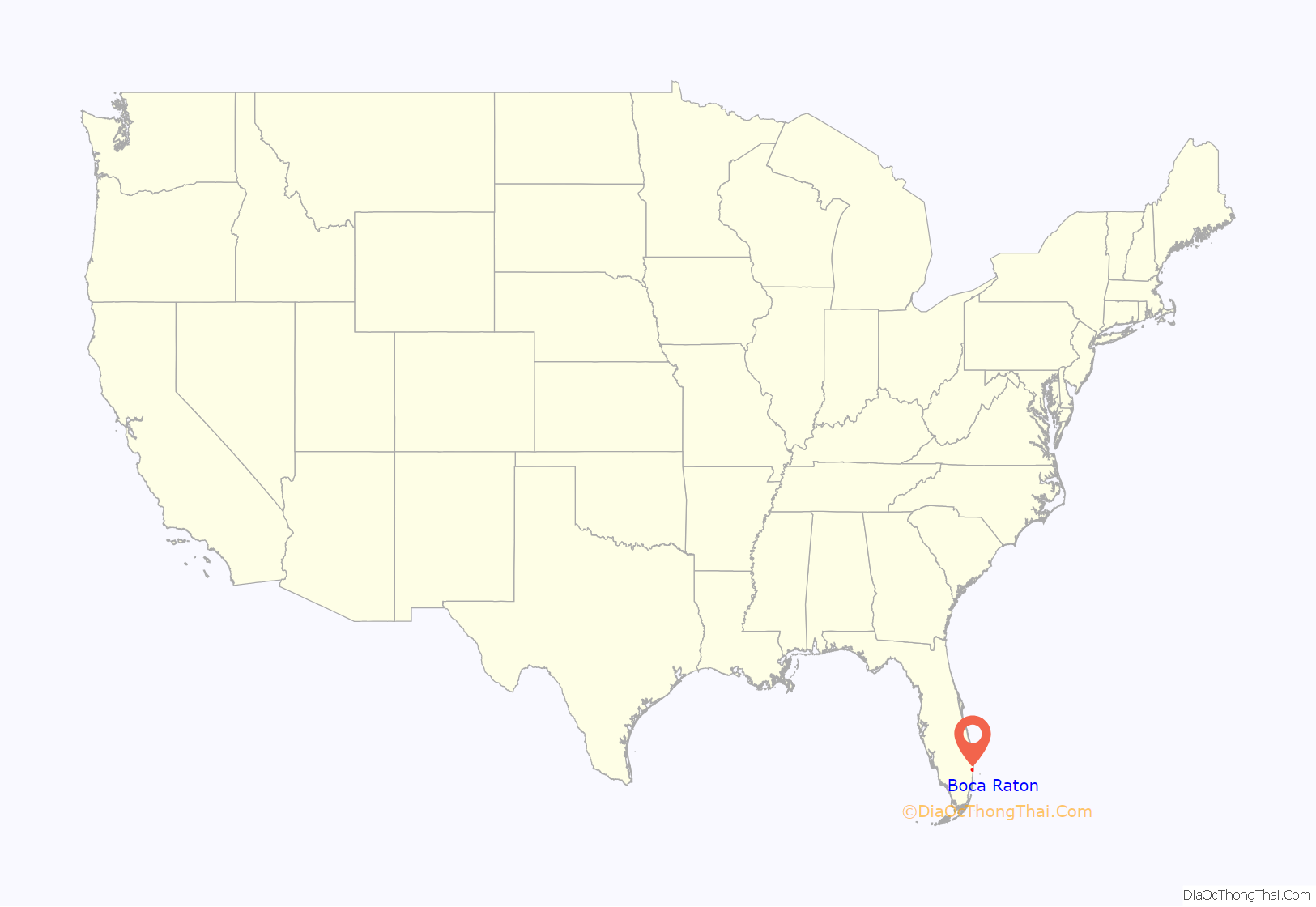
Boca Raton (/rəˈtoʊn/ rə-TOHN; Spanish: Boca Ratón, [ˈboka raˈton]) is a city in Palm Beach County, Florida, United States. The population was 97,422 in the 2020 census and it ranked as the 344th largest city in the United States in 2021. However, many people with a Boca Raton postal address live outside of municipal boundaries, such as in West Boca Raton. As a business center, the city also experiences significant daytime population increases. A part of South Florida, Boca Raton is 45 miles (72 km) north of Miami and is a principal city of the Miami metropolitan area, which had a population of 6,012,331 as of 2015.
It was first incorporated on August 2, 1924 as “Bocaratone,” and then incorporated as “Boca Raton” on May 26, 1925. While the area had been inhabited by the Glades culture, as well as Spanish and later British colonial empires prior to its annexation by the United States, the city’s present form was developed predominantly by Addison Mizner starting in the 1920s. Mizner contributed to many buildings in the area having Mediterranean Revival or Spanish Colonial Revival architecture. Boca Raton also became a key city in the development of the early computer industry. The city is the birthplace of IBM’s first personal computer and various other technologies created by the company. Brightline has a Boca Raton station that provides passenger rail service to Miami and eventually Orlando.
Still centered around luxury beach culture, the city today is dotted by many malls and shopping centers, including the Town Center at Boca Raton. The ODP Corporation, which operates Office Depot and OfficeMax, is headquartered here. Boca Raton is also home to the main campus of Florida Atlantic University and the Evert Tennis Academy, owned by former professional tennis player Chris Evert. The city has a strict development code for the size and types of commercial buildings, building signs, and advertisements that may be erected within the city limit, which has led to major thoroughfares without billboards and large advertisements, as well as increased green spaces on roads.
| Name: | Boca Raton city |
|---|---|
| LSAD Code: | 25 |
| LSAD Description: | city (suffix) |
| State: | Florida |
| County: | Palm Beach County |
| Incorporated: | May 26, 1925 (1925-05-26) |
| Elevation: | 13 ft (4 m) |
| Total Area: | 31.59 sq mi (81.81 km²) |
| Land Area: | 29.18 sq mi (75.57 km²) |
| Water Area: | 2.41 sq mi (6.23 km²) |
| Total Population: | 97,422 |
| Population Density: | 3,338.77/sq mi (1,289.11/km²) |
| Area code: | 561 |
| FIPS code: | 1207300 |
| GNISfeature ID: | 0279123 |
| Website: | www.myboca.us |
Online Interactive Map
Click on ![]() to view map in "full screen" mode.
to view map in "full screen" mode.
Boca Raton location map. Where is Boca Raton city?
History
Timeline
Early history
The area where Boca Raton is now located was originally occupied by the Glades culture, a Native American tribe of hunter-gatherers who relocated seasonally and between shellfish sources, distinct from the Tequesta to the south and the Jaega to the north.
What Spanish voyagers called “Boca de Ratones” was originally to the south, in present-day Biscayne Bay in Miami-Dade County. The area of Boca Raton was labeled “Rio Seco”, meaning “Dry River”, during this time. By mistake during the 19th century, mapmakers moved this location to the north and began referring to the city’s lake, today known as Lake Boca Raton, as “Boca Ratone Lagoon” and later “Boca Ratone Sounde.” An inland stream near the lake was later renamed Spanish River, and eventually became part of the Intracoastal Waterway.
When Spain surrendered Florida to Britain in 1763, the remaining Tequestas, along with other Indians who had taken refuge in the Florida Keys, were evacuated to Cuba. In the 1770s, Bernard Romans reported seeing abandoned villages in the area, but no inhabitants.
The area remained largely uninhabited for long afterwards, during the early years of Florida’s incorporation in the United States. The first significant European settler to this area was Captain Thomas Moore Rickards in 1895, who resided in a house made of driftwood on the east side of the East Coast Canal, south of what is now the Palmetto Park Road bridge. He surveyed and sold land from the canal to beyond the railroad north of what is now Palmetto Park Road. Early settlement in the area increased shortly after Henry Flagler’s expansion of the Florida East Coast Railway, connecting West Palm Beach to Miami.
Addison Mizner’s resort town
- 1890 – Bocaratone settled.
- 1896 – Florida East Coast Railway begins operating.
- 1909 – Bocaratone becomes part of newly created Palm Beach County.
- 1912 – Intracoastal Waterway opens.
- 1915
- Telephone installed.
- Board of Trade organized.
- 1918 – Ebenezer Baptist Church founded in Pearl City neighborhood.
- 1923 – Boca Raton Inlet bridge constructed.
- 1924
- Town of “Boca Ratone” incorporated.
- Addison Mizner chosen as town planner.
- George Long becomes mayor.
- 1925
- Town of “Boca Raton” incorporated.
- Mizner Development Corporation in business.
- 1926
- Cloister resort built.
- Chamber of Commerce founded.
- 1927 – Town Hall built.
- 1928 – Water plant built.
- 1930
- Railroad station built.
- Population: 447.
- 1936 – Airport established.
- 1939 – Camino Real Bridge opens.
- 1942 – U.S. military Boca Raton Army Air Field established.
- 1947 – October: 1947 Cape Sable hurricane occurs.
- 1950
- Art Guild established.
- Population: 992.
- 1955 – Boca Raton News begins publication.
- 1960 – Population: 6,961.
- 1961
- Florida Atlantic University founded.
- Boca Raton Public Library building constructed.
- 1962
- Lynn University established.
- Saint Andrew’s School opens.
- 1963 – Boca Inlet Bridge opens.
- 1964 – Boca Raton Theatre in business.
- 1970 – Population: 28,506.
- 1972 – Boca Raton Historical Society founded.
- 1979 – Jewish Floridian of South County newspaper begins publication.
- 1980
- Pope John Paul II High School established.
- Town Center at Boca Raton opens.
- 1981 – August: “IBM (International Business Machines) introduces the IBM PC from its Boca Raton factory.”
- 1986 – Boca Raton Museum of Art active.
- 1989 – Boca Raton station opens.
- 1990
- Old Floresta designated a city historic district.
- Population: 61,492.
- 1991 – W.R. Grace & Co. headquarters relocated to Boca Raton from New York.
- 1998 – City website online (approximate date).
- 1999 – W.R. Grace & Co. headquarters moves away from Boca Raton.
- 2000
- Muvico cinema in business.
- Population: 83,255
- 2001 – Anthrax attack; Robert Stevens dies.
- 2004 – September: Hurricane Frances and Hurricane Jeanne occur.
- 2005 – October: Hurricane Wilma occurs.
- 2009 – Boca Raton News ceases publication.
- 2010 – Population: 84,392.
- 2012
- October 22: United States presidential debate held in Boca Raton.
- 2014 – Susan Haynie elected mayor.
- 2017
- Ted Deutch becomes U.S. representative for Florida’s 22nd congressional district.
- September: Hurricane Irma occurs.
Boca Raton as a city was the creation of architect Addison Mizner. Prior to him, Boca Raton was an unincorporated farming town with a population of 100 in 1920.
In 1925, Mizner announced his plan for “the foremost resort city on the North American continent,” “a new exclusive social capital in America.” After spending several years in Palm Beach, where, in his own words, he “did more than any one man to make the city beautiful,” and designed the Everglades Club among many other buildings, in Boca Raton his plan was to create from scratch “a resort as splendid in its entirety as Palm Beach is in spots.”
Activity in that area began at least a year, and probably more, before Mizner’s announcement. Land acquisition, tens of thousands of acres, was the largest part. But it is hard not to see Mizner’s hand in the incorporation of Boca Raton in 1924; the city immediately appointed him Town Planner. The Mizner Development Company was incorporated in 1925, and promptly issued $5 million of stock, which was fully subscribed in less than a week. $500,000 was reserved for the “average Floridian”; the remainder was purchased by, as Addison called them, “noted personages”, all with a Palm Beach connection: Lytle Hall, Harold Vanderbilt, J. Leonard Repogle, the Duchess of Sutherland, Rodman Wanamaker, Paris Singer, Irving Berlin, Madame Frances Alda, W. C. Robinson, H. H. Rodgers, D. H. Conkling, A. T. Herd, Porte, William Kissam Vanderbilt II, Elizabeth Arden, Jesse Livermore, Clarence H. Geist, and T. Coleman du Pont as chairman. Addison’s brother Wilson also appears on the list of investors, but he had little to invest.
Instead of the existing Palmetto Park Road, the main street in Mizner’s Boca was to be El Camino Real, 20 lanes wide, which Mizner fancifully translated as “The Royal Highway”, referring to Spain’s road network and to the road to Santa Fe and to the Spanish missions in California. (Spanish kings rarely or never travelled on these roads; “The Government Road” would be just as accurate.) It was originally to be circular, with a lagoon in the middle. Soon it became, in the plans, Boca Raton’s main east-west street, to be 220 feet (67 m) wide and with a canal for pleasure boats in the center. (In the drawing of it on the cover of Mizner Development’s first brochure is a Venetian gondola.) His statement that it was inspired by Botafogo, a neighborhood and beach in Rio de Janeiro, Brazil, is another of his many inventions of foreign “facts”. Mizner, who never went to Brazil nor knew Brazilians, simply made it up because the name “Botafogo” (“mouth of fire”) sounded impressive, as was the concept of imitating Rio de Janeiro. (The only street in Rio de Janeiro anything like the supposed picture, actually an artist’s conception, of “Botafogo” that Mizner included in his first catalogue, is the pt:Canal do Mangue, which runs down the middle of two streets, but is nowhere near Botafogo, a more elegant name than Mangue “mangrove”.)
Only 0.5 miles (0.80 km) of the road was built (although the street has subsequently been extended to the west at normal scale). According to drawings, the centerpiece of the street was to be a canal for pleasure boats; it was never built. All streets were to be at least 60 feet (18 m) wide.
His first buildings in Boca Raton were his Administrative Buildings, on El Camino Real (in 2018 the Addison Restaurant), and a small hotel to house interested investors. Mizner designed Boca’s first town hall/police station/fire station/library, although the design actually built is much smaller and less expensive than what Mizner planned. Today (2018) it is the Boca Raton History Museum, which houses Boca’s Welcome Center and the Boca Raton Historical Society.
The hotel was his Ritz-Carlton Cloister Inn, built in 1926, later renamed the Boca Raton Resort & Club, and is one of the only “5 star” hotels in Florida. The 1969 addition of its “pink tower” hotel building is visible from miles away as a towering monument on the Intracoastal Waterway.
Because of the end of the Florida land boom of the 1920s and the 1926 Miami hurricane, the Mizner Development Corporation went into bankruptcy in 1927. Little of Mizner’s Boca Raton was ever built: his Administration Buildings, the Cloister Inn, 1/2 mile of El Camino Real, the small Dunagan Apartments (demolished), a few houses near the Cloister Inn (demolished), the Spanish Village neighborhood, and a few small houses in what is now the Old Floresta Historic District neighborhood.
World War II Army Air Force Base
During World War II, some of the land used by the Japanese farmers of the Yamato Colony was confiscated and used as the site of the Boca Raton Army Air Force Base, a major training facility for B-29 bomber crews and the only facility in the U.S. training radar operators. Much of the Boca Raton Army Airfield was later donated to Palm Beach County and became the grounds of Florida Atlantic University. Many of FAU’s parking lots are former runways of the airbase. When viewed from above, the site’s layout for its previous use as an airfield is plainly evident. Boca Raton Airport’s runway was once part of the original airbase, and is still active to this day, although the runway has been rebuilt. Army School Building #3 (T-604) of the Army Air Forces Base has survived as the office building for the Cynthia Gardens apartment complex on Northwest 4th Avenue.
Post-World War II history
Boca Raton was the site of two now vanished amusement parks, Africa U.S.A. (1953–1961) and Ancient America (1953–1959). Africa U.S.A. was a wild animal park in which tourists rode a “Jeep Safari Train” through the park. There were no fences separating the animals from the tourists. It is now the Camino Gardens subdivision one mile west of the Boca Raton Hotel. A red wooden bridge and remnants from the Watusi Geyser and Zambezi Falls, a 30-foot waterfall, from Africa USA can still be seen at the entrance to Camino Gardens. Ancient America was built surrounding a real Native American burial mound. Today, the mound is still visible within the Boca Marina & Yacht Club neighborhood on U.S. 1 near Yamato Road.
In the late 1960s, IBM announced their intentions to open a manufacturing plant in the area. In 1965, well before the extension of I-95 into Southern Florida, IBM, working in secret with the Arvida corporation, quietly purchased several hundred acres of real estate west of the CSX rail line and northwest of Florida Atlantic University. Originally situated in unincorporated Palm Beach County, the site was annexed into Boca Raton almost a year following its dedication in 1970.
Construction of IBM’s main complex began in 1967, designed by Marcel Breuer, and the manufacturing and office complex was dedicated in March 1970. The campus was designed with self-sufficiency in mind and sported its own electrical substation, water pumping station, and rail spur.
By 1984 IBM was Palm Beach County’s largest corporate employer, with 8,500 Boca Raton employees. Among other noteworthy IT accomplishments, such as the mass production of the System/360 and development of the Series/1 mainframe computers, IBM’s main complex was the birthplace of the IBM PC, which later evolved into the IBM Personal System/2, developed in nearby Delray Beach. Starting in 1987, IBM relocated its manufacturing for what became the IBM PC division to Research Triangle Park in Raleigh, North Carolina, and converted the manufacturing facilities into offices and laboratories, later producing products such as the OS/2 operating system and VoiceType Dictation, later known as ViaVoice voice-recognition software.
IBM maintained its facilities in the South Florida area until 1996, when the facility was closed and sold to Blue Lake Real Estate. The site was sold to T-REX Management Consortium, then to the Blackstone Group in 2005, who renamed it the Boca Corporate Center and Campus. The site was later renamed the Boca Raton Innovation Campus (BRiC). Crocker Partners, noted for its development of Mizner Park and Office Depot headquarters, purchased BRiC in April 2018.
What used to be IBM’s Building 051, an annex separated from the former main IBM campus by Spanish River Boulevard, was donated to the Palm Beach County School District and converted into Don Estridge High Tech Middle School. It is named after Don Estridge, whose team was responsible for developing the IBM PC. IBM returned in July 2001, opening the software development laboratory at Beacon Square off Congress Avenue.
It is noteworthy that still left standing inside the old IBM complex is the office and conference table where Bill Gates signed his historic deal to supply IBM with the Microsoft MS-DOS operating system for its personal computer line.
In the 1980s, because of an explosion of development to the west of the historical center of the city, some eastern areas began to decay, including the downtown corridor. For instance, the old Boca Raton Mall, a shopping mall in the downtown area, was beginning to experience higher vacancy, and occupancy by marginal tenants, owing to the opening of Town Center at Boca Raton west of the city in 1980.
In 1991, the new downtown outdoor shopping and dining center, Mizner Park, was completed over the site of the old Boca Raton Mall. It has since become a cultural center for southern Palm Beach County. Featuring a landscaped central park between the two main roads (collectively called Plaza Real) with stores only on the outside of the roads, Mizner Park resembles a Mediterranean suburban “town center” with a more contemporary look. It features many restaurants and is home to the Boca Raton Museum of Art, which moved to the new facility in 2001. In 2002, a new amphitheater was built, replacing a smaller one and providing a large-capacity outdoor venue where concerts and other performances are held. The Mizner Park Cultural Center, an indoor performing arts/comedy show theater is located to the southwest of the amphitheater within the Mizner Park property.
The National Cartoon Museum was built on the southwest edge of Mizner Park in 1996. Open for six years, the museum relocated to its original home in New York City in 2002.
As development continued to focus to the west of the city in the 1980s and 1990s, the mall area known as Town Center at Boca Raton became the geographic center of what is referred to as West Boca Raton, though this mall was not annexed into the city until 2004.
Forbes ranked Boca’s Royal Palm Yacht and Country Club the third most exclusive gated communities in the US in 2017. Many mansions and estates have been built and reflect the high real estate values. 18.1% of homes for sale are within the $655,000–$966,000 range, 8.5% in the $966,000–$1.288 million range, and 11.9% in the $1.288 million plus range. Since the mid-2010s, there has been a developing boom such as the building of the Mandarin Oriental’s Residences, remodeling of Downtown Boca Raton’s Mizner Park, and development around Florida Atlantic University and Lynn University.
On November 2, 2004, the voters of the Via Verde Association, Waterside, Deerhurst Association (Boca South), Marina Del Mar Association, Rio Del Mar Association (both originally Boca Del Mar communities), and Heatherwood of Boca Raton Condominium Association approved annexation into the Boca Raton city limits, increasing the city land area to 29.6 square miles (77 km). A new gated community called Royal Palm Polo was annexed to the City of Boca Raton, which is the only jurisdiction north of Clint Moore Road.
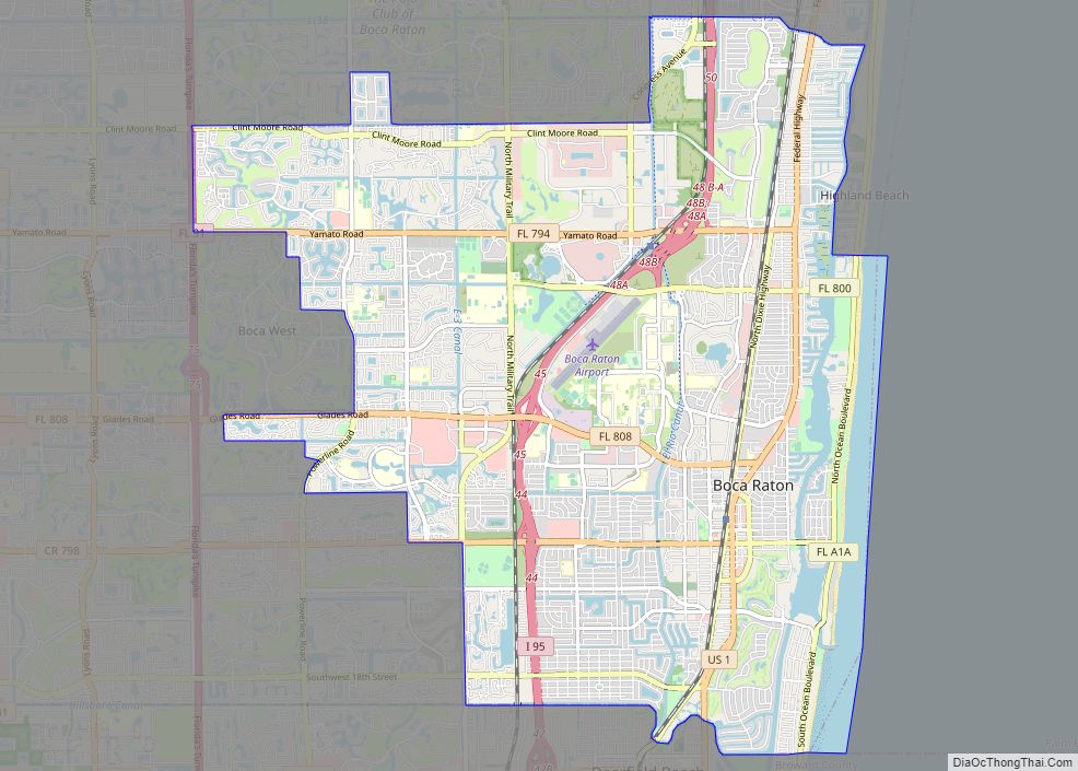
Boca Raton Road Map
Boca Raton city Satellite Map
Geography
According to the United States Census Bureau, the city has an area of 29.1 sq mi (75.4 km), of which 27.2 sq mi (70.4 km) of this is land and 1.9 sq mi (5.0 km) of it (6.63%) is water. Boca Raton is a “principal city” (as defined by the Census Bureau) of the Miami metropolitan area. Approximately 1 square mile is on the barrier island Deerfield Beach Island (DBI), also colloquially known as Deerfield Cay. Like other South Florida cities, Boca Raton has a water table that does not permit building basements, however plumbing and sewage is constructed underneath the homes and streets, in addition to electrical systems in some areas. There are several high points in the city, such as 4th Avenue which is aptly named “High Street.” The highest point in this area is the guard shack at Camino Gardens, which is 24 ft (7.3 m) above sea level. The Boca Raton Hotel’s Beach Club rests at 23 ft (7.0 m) above sea level.
Several small tunnels run under roads in Boca, but the roads are built up several feet at these locations, or are on dunes. Several of these tunnels are under State Road A1A at Spanish River Park, from the west side of the road where parking is available to beachgoers, to the east side of the road, which is where the beach is located. A1A is already higher than the surrounding land here due to sand dunes formed by erosion and other natural features.
Neighborhoods
Pearl City is a neighborhood in Boca Raton, immediately north of downtown and within city limits. The neighborhood was originally platted on May 30, 1915 for the blue-collar African Americans employed at the Boca Raton Resort and similar establishments, on area farms, in construction, and various other jobs.
Climate
Boca Raton has a tropical rainforest climate (Köppen climate classification Af), as its driest month (December) averages 62.5mm of precipitation, narrowly meeting the minimum standard of 60mm in the driest month to qualify for that designation. In general the climate is warm and sunny much of the year, although daily thundershowers occur in the hot season from June through September. Boca Raton is frost free. The warm tropical climate in South Florida supports the growth of tropical trees and plants such as the coconut palm that was introduced hundreds of years ago to Florida in nearby West Palm Beach.
Winter high temperatures are typically in the 75–83 degrees range, while summer high temperatures are about 87–92 degrees.
See also
Map of Florida State and its subdivision:- Alachua
- Baker
- Bay
- Bradford
- Brevard
- Broward
- Calhoun
- Charlotte
- Citrus
- Clay
- Collier
- Columbia
- Desoto
- Dixie
- Duval
- Escambia
- Flagler
- Franklin
- Gadsden
- Gilchrist
- Glades
- Gulf
- Hamilton
- Hardee
- Hendry
- Hernando
- Highlands
- Hillsborough
- Holmes
- Indian River
- Jackson
- Jefferson
- Lafayette
- Lake
- Lee
- Leon
- Levy
- Liberty
- Madison
- Manatee
- Marion
- Martin
- Miami-Dade
- Monroe
- Nassau
- Okaloosa
- Okeechobee
- Orange
- Osceola
- Palm Beach
- Pasco
- Pinellas
- Polk
- Putnam
- Saint Johns
- Saint Lucie
- Santa Rosa
- Sarasota
- Seminole
- Sumter
- Suwannee
- Taylor
- Union
- Volusia
- Wakulla
- Walton
- Washington
- Alabama
- Alaska
- Arizona
- Arkansas
- California
- Colorado
- Connecticut
- Delaware
- District of Columbia
- Florida
- Georgia
- Hawaii
- Idaho
- Illinois
- Indiana
- Iowa
- Kansas
- Kentucky
- Louisiana
- Maine
- Maryland
- Massachusetts
- Michigan
- Minnesota
- Mississippi
- Missouri
- Montana
- Nebraska
- Nevada
- New Hampshire
- New Jersey
- New Mexico
- New York
- North Carolina
- North Dakota
- Ohio
- Oklahoma
- Oregon
- Pennsylvania
- Rhode Island
- South Carolina
- South Dakota
- Tennessee
- Texas
- Utah
- Vermont
- Virginia
- Washington
- West Virginia
- Wisconsin
- Wyoming
